i
GEOCODING TRANSMISSION FOR TRACKING SYSTEM BASED ON LOCATION-AWARE SERVICES
AHMAD FAUZAN B. KADMIN
PROJECT REPORT SUBMITTED AS PARTIAL FULFILMENT OF THE REQUIREMENTS FOR THE DEGREE OF
MASTER OF ENGINEERING
FACULTY OF ENGINEERING AND BUILT ENVIRONMENT UNIVERSITI KEBANGSAAN MALAYSIA
BANGI
ii
PENGHANTAR PENGGEOKODAN UNTUK SISTEM PENGESANAN BERASASKAN PERKHIDMATAN BERPANDUKAN LOKASI
AHMAD FAUZAN B. KADMIN
LAPORAN PROJEK YANG DIKEMUKAKAN UNTUK MEMENUHI SEBAHAGIAN DARIPADA SYARAT MEMPEROLEH IJAZAH
SARJANA KEJURUTERAAN
FAKULTI KEJURUTERAAN DAN ALAM BINA UNIVERSITI KEBANGSAAN MALAYSIA
BANGI
iii
DECLARATION
I hereby declare that the work in this thesis is my own except for quotations and summaries which have been duly acknowledged.
19th January 2015 AHMAD FAUZAN B. KADMIN
iv
ACKNOWLEDGEMENTS
I would like to praise to Allah S.W.T to bless me with great health, time and maturity to help me completed this great master project. I would like to express my gratitude to my supervisor Dr. Nasharuddin Zainal for the useful comments, remarks and engagement through the learning process of this mater project. Furthermore, I would like to thank Mohd Saad Hamid for introducing me to the topic as well for the support on the way.
v
ABSTRACT
Researcher has studied location information because it become important to people that it plays a part in our live especially to unknown destination. They need to know at least two important information, which are the routes they are taking and the time needed to arrive to the destination to prevent losses of time and unwanted waiting for unnecessary events. Modern days in under technology offered smartphones as a technology that help users for their daily task, smartphones are highly integrated devices with basic mobile functions, which has many useful application such as high speed Internet surfing, media playing, photo taking and many more thus it can provide with location-aware services information. Location-aware services become popular because most location-aware services application applies GPS to acquire location data and location information used for navigation. The location information provide routes and traveling time information, basic information about surrounding area of the destination, weather forecast, currency converter, etc. The location information are developed from Geocoding programming and it can be applied to UKM campus application. Sometimes, students and visitors are facing difficulties when finding route in UKM campus, searching UKM campus information, updating latest activity held in UKM and tracking UKM‟s bus travelling time and location. There is needs to develop a solution that can resolve those problems. Based on those problem statements, the objective of project is to design and develop an interactive iPhone application called UKMy. This application will not be directly concerned with providing a feature rich application, but rather it will focus building a prototype of an application that can
support UKM‟s students and visitors when they are exploring UKM. The application
vi
ABS TRAK
vii
CONTENTS
Page
DECLARATION iii
ACKNOWLEDGEMENT iv
ABSTRACT v
ABSTRAK vi
CONTENTS vii
LIST OF TABLES x
LIST OF FIGURES xi
LIST OF ABBREVIATIONS xiii
CHAPTER I INTRODUCTION
1.1 Overview 1
1.2 Location Services and Map 1
1.3 Problem Statement 2
1.4 Research Objectives 3
1.5 Research Goal 3
1.6 Research Scopes 4
1.7 Master Project Organization 4
1.8 Summary 5
CHAPTER II LITERATURE REVIEW
2.1 Introduction 6
2.2 Location-Aware Services 6
2.2.1 Location-Aware Services In Education 7 2.2.2 Application Development In Mobile Devices 8 2.2.3 Application For Education 9 2.2.4 Future Development In Location-Aware Services 9
2.3 Location Tracking Of Mobile Devices 10
2.3.1 GPS-Based Positioning 10
2.4 GPS Vehicle Tracking System 11
viii
CHAPTER III METHODOLOGY
3.1 Introduction 15
3.2 Mobile Application Framework Formulation 16
3.2.1 Objective C 2.0 16
3.2.2 iPhone Design Patterns 16
3.2.3 iPhone SDK & Software 17
3.3 Proposed Method 19
3.3.1 Planning Phase 20
3.3.2 Risk Analysis & Prototyping 24 3.3.3 Engineering & Implementation 31
3.3.4 Evaluation 33
3.4 Summary 34
CHAPTER IV RESULTS AND DISCUSSIONS
4.1 Introduction 36
4.2 Testing Phase 36
4.2.1 Requirement Verification 37
4.2.2 Failed Requirement 39
4.2.3 Performance Test 40
4.3 Implementation Of UKMy Features 44
4.4 CoreLocation & Vehicle Tracking Simulation 49
4.5 Database Implementation 51
4.6 Summary 54
CHAPTER V CONCLUSIONS
5.1 Introduction 55
5.2 Conclusion 55
5.3 Recommendations 57
5.3.1 Mobile Devices Interaction 57 5.3.2 Further CoreLocation And Location-Aware
Services Enhancement 57
5.3.3 UKMy Features Enhancement 58
ix
x
LIST OF TABLES
Table No Page
3.1 Hardware And Software Requirement 21
3.2 Functional Requirement 22
3.3 Non-Functional Requirement 23
3.4 iPhone Screen Display Sizes 28
4.1 Hardware And Software Result 37
4.2 Functional Result 38
xi
LIST OF FIGURES
Figure No Page
2.1 MIT- Environmental Detectives Game 7
2.2 Citizen Environmental App 10
2.3 GPS – Intersecting Spheres 11
3.1 Model-View-Controller Pattern 17
3.2 iPhone SDK Architecture 18
3.3 Spiral Model 19
3.4 UKMy Architectural Design 25
3.5 UKMy SQLite Database Structure 26
3.6 UKMy Class Diagram 27
3.7 UKMy Class Geolocation Sequence Diagram 28
3.8 Apple Tab Bar 29
3.9 UKMy Block Diagram 30
3.10 Storyboard Interface Builder In XCODE 32
3.11 Instrument Performance Testing 34
4.1 Memory Leakage Test 41
4.2 CPU Performance Test 42
4.3 Main Menu UI 44
4.4 News UI 45
4.5 UKM Map UI 45
4.6 Facilities UI 46
4.7 Bus UI 46
4.8 Weather Forecast UI 47
4.9 Currency Converter UI 48
4.10 Social Media UI 48
4.11 Contact UI 49
4.12 User Location Within UKM Campus 50
4.13 Route To Facility 50
xii
4.15 SQLite Database 52
4.16 MySQL Database 53
xiii
LIST OF ABBREVIATIONS
GPS Global Positioning System
UKM Universiti Kebangsaan Malaysia
MIT Massachusetts Institute of Technology
GPRS General Packet Radio Services
IDE Integrated Development Environment
OS Operating System
UML Unified Modelling Language
JSON Javascript Object Notation
CPU Central Processing Unit
PHP Personal Home Page
CSS Cascading Style Sheet
API Application Programming Interface
SDK Software Development Kit
UI User Interface
HTML Hypertext Markup Language
SQL Structured Query Language
WWW World Wide Web
1
CHAPTER I
INTRODUCTION
1.1 OVERVIEW
Nowadays, users are depending on smartphones for their daily task, smartphones are highly integrated devices with basic mobile functions that has many useful application such as high speed Internet surfing, media playing, photo taking and many more. There are many third party applications that enrich the function of smartphones. Location-aware services become popular because most location-aware services application applies GPS to acquire location data and location information used for navigation. There are many different Application Programming Interfaces (APIs) are available such as Google Maps API, Apple CoreLocation, ArcGIS Runtime SDK, Microsoft Bing Map SDK and OSMDroid to develop a location-based application (Shi 2013). The most used APIs are Google Map APIs and Apple CoreLocation because they are widely used in iPhone and Android application. It is very interesting to understand how to develop a location-based application on mobile phones that can be used to track location and receive Geocoding data from database to help users when travelling or finding location. This master project will focus on an iPhone application development, UKMy that provides location-aware services for UKM campus students or visitors.
1.2 LOCATION SERVICES AND MAP
2
navigation or for entertainment. There are two pieces important characteristic in location-based information; location services and maps. Location services are provided by the CoreLocation framework, which defines Objective C interfaces for
obtaining about the user‟s location and direction while maps are provided by MAP Kit
or Google Map, which support both the display and annotation of maps similar to those found in the Maps app (Apple 2014).
You can orient users to the surrounding of the environment and keep connect with people nearby by incorporating geographic data into the application. The location-based application can improve the quality of the information that we offer by
knowing the user‟s geographic location where apps with navigation features use location services to monitor the user‟s position and generate updates. Besides that, app
that uses location services also enables social connections among nearby users. A location-based app can receive coordinates and use the coordinates to provide point-to-point direction to users as examples direction to drive and walk (Parida 2013). The app can support several other modes of transport, including taxi, airplane and various public transportation options. With location-based information app, users can find location based on descriptive information, such as name, address or business type by implementing Search API on Map and it will show the results on Map.
1.3 PROBLEM STATEMENT
3
location driven a vehicle by means of GPS (Verm & Bhatia 2013). El-Medany et. al. (2010) supposed cost effective real time tracking system that provides accurate localizations of the tracked vehicle by using GPS and GPRS modules. By means of GPS receiver, proposed system has ability of tracking current position of the vehicle in any specific time. They tested efficiency of the system in different areas on Kingdom of Bahrain using Google maps.
When it comes to exploring UKM campus, most of the time students and visitors are facing difficulties in finding route to certain UKM‟s building, UKM campus information and latest activities held in UKM campus. They always solely
depends on UKM‟s main website ukm.my to search the information which sometimes
take a lot of time when using smartphones and it always consume smartphone batteries power when surfing through internet. Then, when it comes to taking the bus transportation in UKM, time and patience are of essence. In other words, many people using UKM transport buses have experienced time loss because of waiting at the bus stops. So, there is needs to develop a solution that can resolve the problems arise when exploring UKM.
1.4 RESEARCH OBJECTIVES
Based on the motivation above, the objectives for this master project are:
1. To develop Geocoding techniques need to be used to facilitate for tracking system based on location-aware services in mobile applications.
2. To determine the capabilities and limitations of Geocoding transmission in location-aware services in mobile applications using currently available technologies.
1.5 RESEARCH GOALS
4
be worked and keeping support for existing UKM‟s web site. This project will not be
directly concerned with providing a feature rich application, but rather will focus
building a prototype of application that can support UKM‟s student and visitor when
exploring UKM.
The prototype‟s technical goals are:
1. User can be localized.
2. User can perform a search on route to UKM campus.
3. User can be presented the search of UKM campus building using selectable markers on a map and items in a list.
4. User can be presented the search of UKM bus route and traveling time from database.
5. User can perform activities reporting and search latest report from database. 6. Additional features such as social media engagement, weather forecast and
currency converter.
1.6 RESEARCH SCOPES
The main target groups for this Master project are UKM‟s students and visitors who are using iPhone application. This master project may also be interesting to other dealing with location-aware services using Google Map APIs and Apple CoreLocation. This master project wills discus the Geocoding transmission from iPhone persistent memory SQLite database and server MySQL database that will be used in Geolocation of UKM campus and bus.
1.7 REPORT ORGANIZATION
5
description to every aspect about the foundation of this project on research study made to gather information about the application.
Chapter 3 elaborates in detail about methodology used in the project starting from requirement gathering to the design phase followed to implementation phase and evaluation phase on a simulator and actual device. We can find a description of the application‟s features and software/hardware constraint if any. Chapter 4 explains into details of the result of the application evaluation and testing. It is also gives a view how to launch the application and connect to those technologies from iPhone application and then back to the device end. Chapter 5 is all about conclusion of the project and several recommendations to enhance and improve the application.
1.8 SUMMARY
6
CHAPTER II
LITERATURE REVIEW
2.1 INTRODUCTION
This chapter explaining on literature review of location-aware services application previous development, location-aware in education usage, future development of this location-aware services app, GPS based positioning on mobile devices and application in GPS vehicle tracking system. Furthermore, a short overview of applications that are related to this project is given in this chapter. From the point of view of the service, the simplest method of locating the user is to let him/her tell the location. From the point of view of the user, this method requires extra effort because the user needs to define their location and input it to the system as a part of the search.
2.2 LOCATION-AWARE SERVICES
Location-aware applications deliver online content to users based on their physical location. Various technologies employ GPS, cell phone infrastructure, or wireless access points to identify where electronic devices such as mobile phones or laptops are, and users can choose to share that information with location-aware applications (Tien & Phung 2010). Those applications can then provide users with resources such
as a “you are here” marker on a city map, reviews for restaurants in the area, a nap
alarm that is triggered by your specific stop on a commuter train, or notices about
nearby bottlenecks in traffic. Applications might also report a user‟s location to
7
awareness, offering users a location-based filter for online information (Tien & Phung 2010).
2.2.1 Location-Aware Services In Education
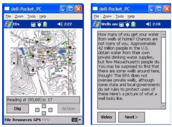
A number of colleges and universities are using this functionality for applications ranging from on campus find-a-friend services to locating resources in the library. Duke University has used Google Maps to add a layer of augmented reality to the Digital Durham project, which has turned the city of Durham, North Carolina, into a laboratory for the study of history (Educause Education 2009). Mapping old tobacco ware- houses, textile mills, and churches, the project offers location- specific information that illuminates the lives of city residents from the 1870s through Prohibition. Concurrent student projects involve adding audio tracks collected with digital recorders and geo-tagging photographs of the mapped locations. Montclair State University has implemented a location-aware service that includes find-a-friend, shuttle tracking, and a security service (MIT 2013). At MIT, the Scheller Teacher Education department has developed augmented reality games like Environmental
Detective as shown in Figure 2.1, in which participants can use location-aware devices
to interview virtual characters and gather simulated scientific data to uncover the source of a hypothetic toxic spill (MIT 2013).
FIGURE 2.1 MIT – Enviromental detectives game
8
2.2.2 Application Development in Mobile Devices
Location tools can be browser plug-ins or installed onto devices like the iPhone or other web-enabled phones. Physical location can be determined using GPS satellites, cell towers, wireless access points, or a combination of these tools. In the case of cell towers and access points, location is determined based on connectivity to individual connection points, which are mapped and logged in databases that are continuously updated. Each method has trade-offs, and the most accurate and reliable services use more than one method (Parida 2013).
When a user with a mobile device elects to use a location service that information is sent to location-aware applications that attempt to provide resources based on where the user is at that moment (Shi 2013). Alternatively, a location-aware
application might forward a user‟s position to other location-aware or social
networking applications. Users can specify which applications receive the information and how detailed that information is, or they can override all other data by entering location coordinates manually.
2.2.3 Applications For Education
These devices offer a convenient layer of content filtering with significant promise for education. Field research is boosted by geo-tagging and embedding location-specific meta data (coordinates or place names) in photos, videos, blogs, or website and location-aware applications can effectively connect geo-tagged resources to students when and where they need it. Geocaching, or coordinate-specific treasure hunting, can be customized in educational games that leverage location-aware mobile devices (Dunlap 2013). These games might include augmented reality simulations that use clues and riddles to enable student problem solving and collaboration. Location-based information can allow students who opt-in to locate members of study groups on campus or check nearby computer labs to see which have unoccupied bays (Federal Communications Commission 2012). Librarians could also point patrons to resources,
based on a user‟s described interests and borrowing habits, by indicating where
9
to student requests to monitor trips across campus to ensure safe arrival at a destination. Data collected from such security requests might be gathered to identify locations with greater security risks, prompting facilities improvements such as improved lighting.
2.2.4 Future Development in Location-Aware Services
Location-aware content offers marketing tailored to the convenience of the user. With increasing frequency, we are able to locate physical services within walking distance as simply as we can find any service or product offered on the web. Mobile devices already reach a public focused heavily on information being delivered quickly and simply. As these tools offer greater amounts of data about the environment through which we move, location-aware systems will become increasingly effective at predicting what we would like to know about in the geographical space around us, offering a layer of knowledge superimposed on the physical world that can be accessed for information and convenience. Through applications like Graffitio, users
can even add their own comments to that layer, “air posting” notes on the nearest
handy Geolocation wall (Educause Education 2009). The geo-tagging of blogs and websites could become part of our expectation of the online experience, and it is possible that we might come to rely on embedded Geolocation information in photos, e-mail, or Twitter posts for archival purposes in much the same way we now rely on date stamps.
10
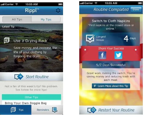
FIGURE 2.2 Citizen environmentalist app
Source: Ocean Conservancy 2014
2.3 LOCATION TRACKING OF MOBILE DEVICES
As location-based services have increased in popularity over the last years, the need for positioning of mobile devices becomes more and more important.
2.3.1 GPS-Based Positioning
The Global Positioning System (GPS) is the leading technology to determine locations on mobile devices. Almost every smartphone on the market has the capability to receive GPS signals. GPS is a freely accessible system based on satellites. To determine a position the GPS receiver needs a line of sight to four or more satellites. Given this fact, GPS only works outdoors.
11
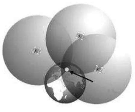
be at one point on this surface. Adding data from a second satellite, another sphere can be drawn. Not considering the unlikely event they intersect in one point, both spheres intersect in a circle. A third sphere, computed by the data of the third satellite narrows the position of the receiver down to two points on this circle. For position determination used by smartphones, the intersection point closest to the earth‟s surface is the correct position of the receiver.
The fourth satellite is to correct the error that arises by the fact that the clock of the receiver is not as accurate as the atomic clocks of the satellites. The accuracy of a position determined by GPS depends on the receiver. Most consumer receivers have an accuracy of 5 to 10 meters (Tien & Phung 2010).
FIGURE 2.3 GPS - Intersecting spheres
Source: Cooksey 2014