I N T E R N A T I O N A L N E W S L E T T E R O F C O A S T A L M A N A G E M E N T
Narragansett, Rhode Island, U.S.A. • Special Edition # 1 • March, 1997
Highlights
4
Mangrove Decline in the Philippines
6 Coastal Monitoring in Nicaragua
13
Options for Abandoned Shrimp Ponds
15
Aquaculture in Madagascar
20
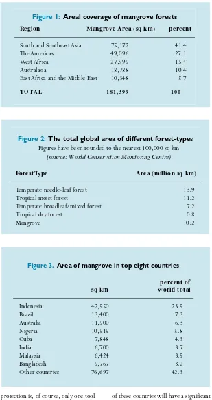
Mangroves Around the World
25 The Role of Ramsar
Mangrove
Management As
Stewardship
By Stephen B. Olsen, Editor
T
he collection of reports and essays in this issue ofIntercoast Networkdemonstrate that there is increasing conver-gence among the diversity of approaches as to how mangrove wetlands should be managed. The many voices and perspectives in this special issue reinforce that progress is indeed being made towards a stewardship ethic for these important and threatened features of tropical coastlines.
The term stewardship presents great difficulties for translators to many of the languages spoken where mangroves predominate. It is therefore often useful to
(continued page 43)
Supporting Appropriate
Mangrove Management
By Marta Vannucci
A
ll cultures which border the sea in the tropical belt of the world have connections with mangroves in one way or another. These range from using mangrove wood for fuel or for making simple rafts (as the aborigines of the Timor Sea in northern Australia do), to the planting of seeds, propag-ules and saplings for coastal protec-tion. In New Zealand, for example, there are remains of rows of mangrove bushes planted to stabilize the coast by early generations of Maori people. In other areas, such as Malaysia,Rhizophorawas specifically planted because of its resistance to rot and boring animals, which makes it good for building houses and jetties. Nypa palms were encouraged to grow for their fronds and sap, and later this species was grown in plantations, for example in Indonesia. The productive waters surrounding mangroves have provided a range of fishery products, such as crustaceans and mollusks, which are harvested in a variety of ways. The waters are used for farming fish and crabs, and even algae, for food or chemicals. Taking one example, when the Portuguese first arrived in India, they learned from the indige-nous people how to use the mangroves to create rice-fish-mangrove farms. Much of this traditional knowledge was described in the letters of the Viceroys to the King of Portugal, and was later taken by Jesuit and Franciscan fathers to Angola and Mozambique where the local people
were trained in the techniques. In other parts of the world, mangroves were considered to be sacred forests, to be used only for the disposal of the dead, as in the Solomon Islands, or for special rites. Elsewhere mangroves have been valued for the beauty of their flowers or used to build impene-trable fences. The uses of this ecosys-tem would fill an encyclopedia.
Scientists were fascinated by the anatomy, histology, physiology and chemicals of the plants and animals adapted to such a demanding environ-ment, and the noted Swedish botanist Linnaeus clearly appreciated the value of mangroves, naming Avicennia offici-nalisafter a famous Arab doctor and the Latin word for medicinal: offici-nalis. However, most of the Europeans who swarmed across the world follow-ing the Age of Discoveries failed to recognize the benefits of this ecosys-tem, other than for capture fisheries
Intercoast Networktries in each issue to give a broad a range of viewpoints, ideas and information on coastal management issues as possible. So one might ask, “Why do a special edition that focuses only on mangroves?”
By doing a special edition,
Intercoastis able to go into depth on a critical issue that cannot be explored as widely or as deeply in a regular issue. Mangroves are an essential component of estuarine systems, filtering inland water as it flows to the sea, and serving as a nursery and primary habitat for abundant and diverse species. The principal funders of this issue, the United States Agency for Inter-national Development (USAID) also took into account how a special issue on mangroves could make the bridge to other key areas in their diverse portfolio of projects.
“Mangrove forests form a vital link between terrestrial ecosystems and coral reefs,” said Michael Benge, head of the USAID Center for the Environment’s Forestry/Global Climate team. “Mangroves are being destroyed very rapidly, mainly due to cutting for charcoal and building ponds for shrimp mariculture–which has proven to be a very unsustainable use. This shortsighted exploitation of mangroves endangers not only the mangrove forests, but also the inter-acting environmental resources and local societies which rely upon their existence.”
By more closely examining this resource within the entire coastal ecosystem, we hope to be able to offer valuable and usable information for those addressing complex man-grove management problems in the field.
Intercoast also works to create
links to other coastal and non-coastal issues that affect non-coastal ecosystems. By expanding our scope and looking outside our traditional readership to a wider range of experts, we hope to find creative tools and techniques, and begin to forge the all-encompassing, “big picture” linkages that are so vital to effective integrated coastal management.
“USAID’s global environmental program well understands the issue of coastal management, and also appreciates the value of mangroves both environmentally and economi-cally. It is essential to increase pub-lic awareness of their value and vul-nerability,” concludes Benge, “so a balance among the uses of man-groves can be achieved and the ben-efits they provide both environmen-tally and economically for future generations can be sustained.“
This expanded special edition of
Intercoast Network is the result of a unique team effort among authors from all parts of the globe, editors on two different continents and financial sup-port from the United States Agency for Internation-al Development Forestry/ Global Climate Change Initiative in its Bureau for Global Programs, Field Support, and Research’s Center for Environment.
This increased financial support allowed us to expand the length of this edition to more comprehensively cover the topic of mangroves and to secure a technical editor–Susan Wells–who could help draw together leading prac-titioners with expertise involving man-grove eco-systems, and to share their experiences and viewpoints in these
pages. Wells, a coastal management professional, worked with Intercoast
staff at the Coastal Resources Center (CRC) at the University of Rhode Island as a guest editor. A native of England, Wells is currently marine programme coordinator at World Wildlife Fund International’s (WWF-International) office in Gland, Switzerland. She is active in a breadth of integrated coastal management ini-tiatives, though more often with a focus on coral reefs than mangroves.
Wells arrived at CRC in the sum-mer of 1996 to take on the challenge of putting out the biggest-ever issue of
Intercoast, with its focus solely on one topic–mangroves. She remained at CRC for three months, working close-ly with editor Stephen Olsen and CRC
staff to identify key managers and experts in the field of mangrove man-agement, and get them on board as contributing writers. In November, she left the U.S. to take on her position with WWF-International. Despite starting a new job, through the modern miracles of E-mail and FAX machines, Sue managed to stay in constant touch with Intercoaststaff and the authors of articles, and helped guide the issue through to final publication. Her expertise, extended network and hard work help make this edition one which we believe will improve integrated coastal management work with man-grove systems all over the world. We thank all of those who contributed to this inspiring effort.
– Chip Young, Managing Editor
W
HY A
S
PECIAL
I
SSUE ON
M
ANGROVES
?
and fuel wood. Mangroves were usually considered to be wastelands, unhealthy for navigation and humans alike. Since the very early 16th century, they were marked on Portuguese charts, often using special symbols to indicate dan-ger for any craft lardan-ger than dugout canoes, rafts and catamarans.
Apart from the management prac-tices used in India, the traditional tam-bak-sari system of Java, Indonesia and other scattered examples, large scale intentional management of extensive mangrove areas started, as far as we know, only in the 19th century. The aims and goals varied with the needs and greed of the power game.
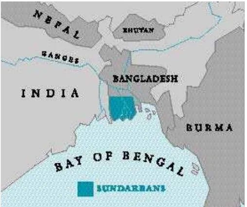
In the second half of the 19th centu-ry, the British applied practical knowl-edge accrued over centuries to the management of the Sundarbans, the “beautiful forests” of the Ganges-Brahmaputra delta, for timber. Watson, also from Britain, developed another forestry management system for the mangroves of the west coast of
penin-sular Malaysia. These two different systems have by and large stood the test of time and illustrate that there is no simple model for mangrove man-agement. The term “mangrove” covers
Mangrove Management
(continued from page 1)
a range of habitat types that have little in common other than the fact that they are inundated by the sea at regu-lar intervals. Mangroves include a vast range of combinations of tidal regimes, climatic variations, species composition, and physical, chemical and microbio-logical composition of soils and water, resulting in widely varying growth, reproduction and productivity. They must therefore be used and managed according to these constraints, bearing in mind the socio-economic needs of local people.
Well into the 20th century, scientif-ic research focused mainly on taxono-my and description, while the “dreaded swamps” were treated with indiffer-ence or downright condemnation by developers, engineers, politicians and the military. Local people largely con-tinued their simple, ecologically safe practices. But, as an old saying goes, “There is no evil that lasts forever nor good that will not come to an end,” and there were major changes during and after World War II. New technolo-gies and methodolotechnolo-gies were introduced to achieve greater financial returns
from mangrove areas, providing quick gains at the cost of permanent wealth.
In many places mangroves have been overexploited for fuelwood, for example in Africa and the small islands
of the Caribbean and Central and South America, and for wood chips for the rayon industry. Developers, guided by foreign investors, often totally disregard legal obligations to replant or conserve buffer zones. The greatest numbers of offenders now are those who clear cut the mangroves to establish intensive shrimp farming. Intensive and semi-intensive methods have been used indis-criminately with total disregard for their suitability, resulting in major changes to the ecology of the area. This, combined with the
inten-sive inputs of feed and fertiliz-er, and aeration, and the spread of epidemic dis-eases, has meant that after a few years the area is so badly degrad-ed that shrimp production has to be aban-doned. New areas are then clear cut. The tropical belt of the globe now looks like a pock-marked face, with much of the land eroded away by
the encroaching sea. The long term sur-vival and needs of local populations are largely ignored.
There are some encouraging signs, however. Tanzania, Pakistan, Bangladesh, India, Thailand, Venezuela and many island nations are among the numerous countries actively engaged in long term programs for sustainable management and use of mangroves. Activities range from the creation of protected areas and scientific studies of flora and fauna of the forests, waters and soil to reforesta-tion and afforestareforesta-tion of the intertidal belt. Two countries–Bangladesh and Pakistan–are mentioned here because they tackle apparently impossible tasks:
Save The Mangroves?
“Oh these mangroves. I never saw one that looked as if it pos-sessed a decent conscience. Growing always in shallow stag-nant water, filthy black mud, or rank grass, gnarled, twisted, stunted and half bare of foliage, they seem like crowds of with-ered, trodden-down old crimi-nals, condemned to the punish-ment of everlasting life. I can’t help it if this seems fanciful. Anyone who has seen a man-grove swamp will know what I mean”.
–An early New Zealand novelist
By Roy Olsen D. De Leon
and Alan T. White
M
angrove forest cover in the Philippines has declined sub-stantially during this century, from about 450,000 hectares (ha) in 1920 to less than 150,000 ha in the late 1980s, of which only 46 percent (68,000 ha) is located outside the islands of Palawan and Mindanao. The most rapid decrease occurred in the 1960s and 1970s when government policies encouraged the expansion of aquaculture during a period when real prices for fish and shrimp were steadily rising. Although national laws prohibit the cutting of any mangroves, and the most impor-tant mangrove forests are protected in forest reserves, this ecosystem typehas continued to decline.
Despite a 1980 government ban on further conversion of mangroves to fish ponds, the reduction of mangrove area since that year through 1991 continued at a rate of about 3,700 ha/year, in parallel with an increase of
fish pond area of approximately 4,100 ha/year over the same period. Today, fish ponds cover about 289,000 ha, with 80-90 percent in areas once cov-ered with mangroves. Cutting of man-groves for charcoal-making, fuel wood and construction is probably the sec-ond most pervasive intrusion on the resource and conversion of mangrove areas to fish ponds has sometimes been just the final step in a process of destruction that began with over-har-vesting of mangroves for fuel wood, frequently by persons other than those who ultimately built the fish ponds. Degraded areas are more easily reclas-sified as disposable lands, which makes conversion more likely. The current situation has therefore prompted the government to develop new policies
for reforestation of mangroves and the recovery of abandoned fish pond areas.
Fish Pond Licensing
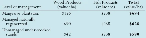
The Bureau of Fisheries and Aquatic Resources (BFAR) is responsible for licensing the development of fish pondson government land. About 95,000 ha has been allocated for this purpose of which some 63,000 ha are under 25-year fisheries lease agreements (FLA). Under the Fishery Sector Program (FSP), initiated in 1991, an economic analysis was carried out which revealed that the fish pond lease fee of US$2 per year per ha was far too low to either encourage efficiency in the use of land for fish ponds or discourage conversion to aquaculture uses. The opportunity cost for the replacement of mangrove systems was determined to be quite high and was consistent with studies in other countries. An 1989 study gave estimates of US$500-1,550 a year for the opportunity cost of one ha of com-plete mangrove ecosystem. The FSP study found that various researchers had determined a minimum economic rent of at least US$550 a year for one hectare of inter-tidal land in the
Philippines (Table 1). The study recommended that FLA lease fees be raised to between $360 and $800 ha/year. It also recognized that the values attributed to marine fishery products dependent on mangrove sys-tem health were uncertain because of lack of informa-tion and so suggested that the basic wood value of mangrove stands be used as the initial economic rent level. This is about $156/ha/year, and a sched-ule was therefore recom-mended to implement an increase of lease fees over several years to this figure. Resistance from leasehold-ers, as well as political inter-vention, has meant that this has not yet been implemented but it is thought that it will eventually happen. Indeed, the renting of privately-owned fish and shrimp ponds is a flourishing market, deriving annual incomes of about US$120-600 per ha.
Mangrove Resource Decline in the Philippines:
Government and Community
Look for New Solutions
Mangrove Reforestation
The Department of Environment and Natural Resources (DENR) is responsible for mangrove management. Experiments in reforestation using contracts with local communities, giv-ing stewardship agreements and encouraging communities to protect and manage the resource in their own way have been successfully carried out on Bohol and Panay. As early as 1964, small mangrove rehabilitation projects began on Bohol Island, Visayas, where harvesting for firewood and poles has long been a practice and where it is understood that if mangroves are thinned, they will grow more effi-ciently. A community in Jetafe refor-ested 100 ha, and students and school officials in Calape planted a 20-m wide band along 4.8 km of coast in 1968 for protection against wind and storm waves.In 1984, an innovative program, the Central Regional Project, using experi-ence from earlier community projects, began to experiment by providing secure tenure over a mangrove area to an individual or family in return for maintaining it as healthy forest. This arrangement was called a Stewardship Agreement and was initially used to promote reforestation in open areas, as national policy at that time did not allow community management of existing mangroves. Mangrove planting progressed rapidly but long-term suc-cess rates were less than 50 percent because information on methods and sites was lacking. Planting outside nat-ural mangrove habitat predisposed efforts to failure and lack of land use planning meant that ownership and tenure were unclear. Furthermore, lack of suitable planting material led to single species dominance in newly planted areas.
These initial experiments resulted in 1990 in the first national policy on mangrove management that encouraged community involvement by providing long-term security of tenure through the issuance of Mangrove Stewardship Agreements. This was followed,
howev-er by a policy of contracting individu-als or groups to plant mangroves. When communities were directly responsible with stewardship agree-ments, the cost/ha was about US$80. The contracting of individuals without any community organization or volun-teer labor, increased the cost to more than US$400/ha. Success was still less than 50 percent and the communities generally participated in the contract-ing exercise to make some additional money without much concern for enhancement of the environment.
In 1991, management of an existing but degraded mangrove forest at Cogtong Bay, Bohol Island was started using a Mangrove Stewardship Agreement. Designated seed trees
were allowed to grow while others were harvested for fuel wood and poles. Forest quality and the abun-dance of naturally occurring seedlings increased, and the need to stop fish pond development was highlighted through community opinion and resis-tance in the area. This success encour-aged the DENR to increase its focus on the rehabilitation and management of existing forest in its programs through community involvement.
The Buswang Mangrove Reforestation Project, started in 1990 in Kalibo, Panay Island, has been particularly suc-cessful. Here, the government con-tracted Kalibo Save the Mangrove Association, an organization with 26 family beneficiaries, to replant 50 ha. After four years, the organization was
able to harvest and earn from the Nypa leaves on five ha of the area. DENR awarded the organization with a 25-year Forest Land Management Agreement in 1995.
In 1993, the DENR therefore stopped its straight contract reforesta-tion efforts and in 1994 endorsed the NGO-assisted Community-Based Mangrove Forest Management approach. Between 1991 and 1994, the FSP also assisted the DENR in the reforestation of about 6,900 ha of mangrove. As with DENR, initially local communities were contracted to plant seedlings and young trees but this caused many problems, and was replaced by a more community-based management system with NGO
assis-tance. Although the target of 30,000 ha was not achieved, the FSP has rec-ognized that involving the community directly is a more sustainable approach to reforestation and maintenance of existing resources. Unfortunately, there is now a conflict between the existing legislation that bans mangrove cutting and the new policies allowing limited use by community stewards. This dis-crepancy in national law and preferred policy will need to be resolved.
New Policies to Support
Sustainable Use and
Management
The official government-approved conversion of mangrove habitat to fish pond use has virtually stopped, an
(continued page 38)
Table 1: Estimated net annual economic value ($US) of Philippine mangrove areas for different levels of management
Wood Products Fish Products To t al
Level of management (value/ha) (value/ha) (value/ha)
Mangrove plantation $156 $538 $ 6 9 4
Managed naturally
regenerated $90 $538 $ 6 2 8
Unmanaged under-stocked
stands $42 $538 $ 5 8 0
experiencing increasing control over the process and are making a number of decisions and taking actions on their own. For example, meetings have been held with local political leaders to dis-cuss natural resource management issues and these leaders have responded with moral and material support.
CAMP is also conducting research that is resulting in valuable information about the par-ticipatory management process itself. Through the use
of qualitative research methods, such as inter-views and participant observation, CAMP staff are assessing the strengths and limitations of the project. This infor-mation is fed back to pro-ject participants for dis-cussion and project reori-entation. During inter-views, the majority of people say that they prefer the participatory approach to the more centralized approaches
to research and development that they have experienced. They feel empowered through the process and have noticed that CAMP is raising the consciousness of local people about the value of their natural resources. While participatory resource management is increasingly common, a thorough longitudinal study of this process is still relatively unique. The documentation of this case study of participatory natural resource monitor-ing and management could be useful for other projects in Latin America.
For more information contact: Roberto Rigby and Patrick Christie, CAMP Co- Coordinators, Centre for the Investigation and Documentation of the Atlantic Coast (CIDCA), P.O. Box 42, Bluefields, Nicaragua; Phone/ FAX: 50-5-82-735; E-mail:
By Roberto Rigby and
Patrick Christie
N
atural resources are the eco-nomic base of 10 coastal com-munities living around Pearl Lagoon, the largest coastal lagoon on the Nicaraguan Caribbean coast. The communities are small, most with less than 500 inhabitants. The cultural diversity of the area is considerable with distinct Miskitu, Garifuna and Creole groups, each of which exploits coastal resources in a different way. The most common occupations are fishing and farming, depending on the season.The lagoon is surrounded by exten-sive mangrove forests, pine savannas (Pinus caribaea), and lowland rain for-est. While the lagoon ecosystem is still in relatively good condition compared to other systems in the region, a num-ber of environmental stresses are of concern to local people. Of greatest importance are the potentially negative effects of large scale sedimentation of the lagoon as the watersheds of its tributaries are deforested by agricul-turalists and logging interests. Over-fishing is now possible with the intro-duction of modern fishing gears and processing plants for export of fish and shrimp to the United States. To date, 62 fish species have been identified in the lagoon. Crocodiles and caymans, once common in lagoon tributaries, have been heavily hunted. The harvest-ing of mangroves for fuel or tannins is limited but there has been recent dis-cussion of the introduction of large scale shrimp culturing into the area.
Since 1993, the Coastal Area Monitoring Project (CAMP) has employed participatory environmental monitoring to document water quality, forest condition, and fish yield that will provide a foundation for the man-agement plan which will be developed by local people. CAMP proposes to
involve neighboring Pearl Lagoon communities and extend research efforts to include other terrestrial and aquatic environments. The develop-ment of local human resources is fun-damental to this process. Communal resource management groups will be established and the training of CAMP
staff and participants in environmental monitoring and management are important activities.
The project is based on a number of important principles. First, CAMP embraces the local perspective since it relies on local knowledge and partici-pation which are critical for the suc-cess of such plans. Second, the man-agement plan considers the social, political, cultural context. Third, data are collected on both terrestrial and aquatic ecosystems, a necessity if the plan is to ensure sustainable resource use. Finally, the concept of resource management as a potential economic and social benefit, rather than a threat, is being promoted through local par-ticipation, and this in turn is helping to develop local capacity for resource management. Already, local people are
The Coastal Area Monitoring Project at
Pearl Lagoon, Nicaragua
By Piyasena Ganewatte
S
ri Lanka’s Coast Conser vation Department (CCD) estimates that there are about 12,000 ha of mangroves for ming a narrow inter tidal belt usually around the perimeter of coastal lagoons, with 14 species of true mangroves and 12 species of mangrove associates. Mangrove research is coordinated by the National Mangrove Committee within the Natural Resources, Energy and Science Authority (NARESA). Members include the National Aquatic Resources Agency (NARA), the Forest Depar tment (responsible for the agement and conser vation of the man-groves), CCD, other gover nment agen-cies and several universities.Rekawa Lagoon, lying on the south-east coast about 200 km from Colombo, has been the site of an intensive par tici-patory planning and management effor t since 1993, focused on the natural shrimp fishery, mangroves, agricultural land use and beach habitat for sea tur-tles. The Rekawa mangroves contribute substantially to the health of the lagoon and its associated fisheries and tradi-tional uses, and suppor t a number of resident and migratory birds. The man-groves for m a narrow fringe along the shoreline of both the channel and the
main basin of the 200 ha lagoon, often interspersed with plants such as Soneratia acidia (Kirala) which is used to make cork. Traditional uses for man-grove products are varied in Sri Lanka and typical of other developing coun-tries. There are also a few uses par ticu-lar to the Rekawa area: the wood is used as fuel for lime kilns, as rafters and poles in house construction and as sticks to suppor t vegetable plants. The plaited fronds of the Nypa palm (Nypa fruticans), are used as thatch in house construction.
A Special Area Management Plan has recently been approved by the local community and the concer ned gover n-ment and research organizations. It focuses on the development and imple-mentation of sustainable use strategies for the mangrove resources through the collaboration of gover nment, NGO s and community groups. The major par tners are the Forest Depar tment, NARA, CCD, Rekawa Special Area Management Coordinating Committee (RSAMCC), Hambantota Integrated Rural Development Project, Rekawa Lagoon Fishery Cooperative Society, the newly established Rekawa
Development Association and the pro-posed Coastal and Lagoon
Environment Education and Research (CLEER) Center.
The major objectives of the Special Area Management Plan in relation to mangrove management are to:
■Establish a Mangrove Forestry Unit in the CLEER Center, suppor ted by the Presidential Task Force of the Souther n Development Authority.
■Develop exper tise in mangrove ecology, mangrove ecosystems and sus-tainable use of mangroves at the CLEER Center.
■Implement a comprehensive sur-vey of the mangroves of Rekawa and the Souther n Province of Sri Lanka and develop a national plan for their sustainable use.
There is also the need to develop and implement a zoning scheme and sustainable use plan for mangrove resources through the RSAMCC. The major activities involved in this are:
■Map locations of prime mangrove stands designated for strict protection.
■Designate areas of mixed man-grove vegetation where limited use will be per mitted.
■For m an agreement between the Forest Depar tment and community groups on joint management of the mangrove resources that stipulates
Collaborative Management
at Rekawa Lagoon, Sri Lanka
(continued page 8)
Rekawa
(continued from page 7)
core areas of strict protection, areas of limited and sustainable use, permitted uses, means of monitoring uses, and designated responsible persons or community groups.
■Formalize an agreement declaring
the area a sanctuary or forest reserve with limited use permits.
■Develop a mangrove park of about
50 ha for research and nature tourism, and commence new livelihood projects such as sale of allowable mangrove products.
■Protect an area for migratory
birds that is close to the area of the proposed CLEER Center.
■Conduct research in collaboration
with the universities of Colombo, Peradeniya, Moratuwa, Ruhuna and NARA.
■Implement a community
aware-ness, education and training program on the sustainable use of the mangroves.
The chief implementing agency for the Rekawa Mangrove Management Plan will be the Forest Department assisted by the CCD, NARA and sever-al universities as needed. The RSAM-CC, consisting of divisional heads and field officers of all development departments and representatives of the NGO sector, and chaired by the Tangalla Divisional Secretary, will serve as the Coordinating Committee. Collaborative management by the
Forest Department and other govern-ment agencies, NGOs and community groups is a unique feature of the plan. An expected outcome is the genera-tion of income and employment through sustainable use of mangrove products. Rekawa is in a good position as the community is already well orga-nized, a community awareness pro-gram has been in operation for more than two years, and community orga-nizations are taking action to minimize mangrove degradation.
For more information contact: Piyasena Ganewatte, Consultant, Coastal Resources Management Project, 1 Gower Street, Colombo 5, Sri Lanka. FAX: 941-500-207.
User Groups Play Key Role
in St. Lucia
By Mathias Burt
and Brett Hudson
S
ince 1981, the Caribbean Natural Resources Institute (CANARI), the government of St. Lucia, and localresource users have been involved in a pro-ject aimed at the conservation of a 60 hectare (ha) mangrove forest on the southeast coast of this small island in the Lesser Antilles. The principal use of the forest is for the production of charcoal, which is a locally impor-tant fuel source. Already it was clear that the prevailing harvest level was depleting the resource base.
The mangrove was declared a marine reserve in 1984, making it
ille-gal to harvest trees there. However, CANARI facilitated the establishment of a resource user’s group which was granted tacit permission by the gov-ernment to continue to produce char-coal in the reserve, at the same time collaborating with CANARI to moni-tor levels of production and trends in biomass. The formation of the user group and the development of other economic activities in the region reduced the number of people work-ing in the mangrove. Improved cuttwork-ing techniques were adopted which allow for better regeneration of harvested areas, and clear cutting has been aban-doned. As a result, the mangrove has begun to recover. Surveys conducted in 1992 demonstrated that stem densi-ties have increased over previous years, while the volume of charcoal being produced also increased.
Despite these improvements, prob-lems remain. One of these is that the legal status and resource management responsibilities of the user group remain uncertain. This ambiguity and the physical characteristics of the resource mean that the user group is
not always able to prevent others from cutting illegally. The result is an insecu-rity of tenure which is a disincentive to conserve. Trees continue to be cut well before they reach the age of maximum productivity for fear that others will cut them down if they are left to mature. A second problem is that part-ly because of the insecurity of tenure, the group has not developed sufficient organizational capacity to assume agement responsibility for the man-grove as originally planned, and they continue to rely heavily on CANARI and the government to perform those functions.
To address both these concerns, the Department of Fisheries now plans to establish a local management authority for the mangrove, which would involve the user group in a co-management agreement with government agencies, CANARI, and other interested parties. Hopefully, this will consolidate the char-coal producer’s legal rights to harvest, and provide the management expertise required to enhance the conservation of this important local resource.
T
he rich natural resources of the Mekong Delta are of vital importance to Viet Nam. Covering an area of 3,900,000 hectares (ha), the delta supports major agriculture and aquaculture industries, with the man-grove forests providing a myriad of eco-logical functions and multiple uses, such as substantial small-scale fisheries, forest and non-timber forest products and a buffer against frequent storm surges. Excessive lumbering for timber and aerial spraying of defoliants during the Viet Nam War devastated large stretches of mangrove forest and caused a serious decline in biodiversity. More recently there has been widespread conversion into low-production aqua-culture farms. Important fauna popula-tions in the remnant mangrove forests are under great pressure due to habitat destruction and poaching. Loss of man-groves has also led to changes in coastal morphology, as the remnant forests no longer provide adequate protection. In the western part of the Delta there is accelerated accretion, whereas coastal abrasion is serious in the south-east, with up to 70 meters of land being lost per year, and frequent flooding and salt water intrusion ensues.In March 1996, the government established the Rehabilitation of Mangrove Forests (RMF) Project for the Mekong Delta as a follow-up to the 1990-1994 UNDP/World Bank-funded Mekong Delta Master Plan (MDMP) and the 1995-96 World Bank-funded Coastal Wetlands Protection and Development Project. The RMF project aims to rehabilitate degraded mangrove forests along the south-eastern coast of the Mekong Delta in the provinces of Minh Hai and Soc Trang.
Some 145,000 people in this region are assumed to be directly or indirectly dependent on mangroves, and are main-ly engaged in shrimp farming, crash
crop production, salt mining, fuel wood collection and fishing. Before 1960, Minh Hai was covered with some 200,000 ha of mangrove, mainly in the peninsular of Ca Mau, but dur-ing the war more than half of this was destroyed. At present less than 60,000 ha is left and 340 kilometers (km) of coastline requires urgent protection against abrasive wave action. In the province of Soc Trang 60 km of the 72 km of shoreline are subject to serious coastal erosion.
From the outset, it was clear that in order to acquire legitimacy for the local stakeholders, the project would have to establish benefits for them and seek their active involvement. The pro-ject is therefore combining mangrove protection with aquaculture develop-ment, the feasibility of this approach having been assessed during the MDMP. After rehabilitation, the man-grove forest will be managed through community participation, according to a model established by the Forestry Department which is based on a com-bination of mangrove reforestation and shrimp farming with a clearly outlined responsibility for joint management. It involves providing 5-10 ha blocks of degraded mangrove area to individual farmers/fishermen. Under a lease arrangement, governed by a contract, 20-30 percent of this area may be used for aquaculture development, while the remainder must be reforested.
Phase I of RMF comprises detailed biophysical and socio-economic sur-veys to map current land use and sites in need of mangrove rehabilitation and reforestation. Workshops are being held to help communities understand the need for management of their sources of livelihood. Conservation education programs will focus on the importance of mangroves.
Appropriate reforestation techniques
will be tested including optional nurs-ery management, site preparation and management, species selection and tending and management of seedlings.
During Phase II, 6,600 ha will be re-planted. Four management strategies will be considered:
■Reforestation of seriously degraded
or cleared coastal areas.
■Rehabilitation or additional
planti-ng in partly degraded maplanti-ngrove forests.
■Natural regeneration in partly
degraded areas where abundant natural seedlings are available.
■Active management and
protec-tion in areas with vigorous mangrove growth.
The project comes under the Ministry of Agriculture and Rural Development and is implemented by the provincial forestry departments. Technical assistance is provided by the Forest Inventory and Planning Institute, the Research Institute for Aquaculture and the Netherlands consultancy firms Euroconsult and Haskoning. While tech-nical knowledge is available within the former Forestry Department, staff lack hands-on experience in mangrove forestry extension and working with local communities. The RMF project is seeking to strengthen the managerial and institutional capacity of the relevant agencies. It is focusing on pilot imple-mentation for a number of selected sites and it is hoped it will have a positive effect on the income levels of families directly involved. A major component will be on-the-job training in silvicul-ture techniques, people’s participation and empowerment and conservation education techniques.
For more information contact: L.B. van Lavieren, Senior Forestry Specialist; or W im J.M. Verheught, Director, Ecological Services Department, Euroconsult, P.O. Box 441, 6800 A K Arnhem, The Netherlands. FAX: +31-26 3577 577. W andert Benthem is Team Leader, Rehabilitation of Mangrove Forests, Mekong Delta; Dr. Nguyen Duy Chuyen is Deputy Director, Forest Inventory and Planning Institute.
Rehabitating the Mangrove
Forests of the Mekong Delta
By Bill Streever
I
n Australia, rehabilitation of both inland and coastal wetlands has become increasingly common since 1990, and new government policies offer additional impetus for such activities. The Kooragang Wetland Rehabilitation Project (KWRP), which oversees rehabilitation at three Hunter River estuary sites, provides an exam-ple of effective interaction between researchers from the Univer-sity of Newcastle and a community-driven wetland rehabilitation project. Scientists often lose sight of ecosystem managers’ needs, while managers may not understand scientists’ methods and rationale. A research plan was there-fore drawn up that formalized the rela-tionship between rehabilitation man-agement and research and recognized two distinct roles for research. Proactive research provides managers with information before a management decision is taken, while reactive research assesses the impact of man-agement decisions by monitoring ecosystem change. This model–relating management, reactive research and proactive research–is being tested through a simple study and will help to clarify the role of scientific investi-gation in rehabilitation.Wetlands within the three rehabili-tation sites typically consist of salt marsh and mangrove forests. Over the past 200 years, the region’s estuarine wetlands have suffered from drainage for agriculture, industrial development and waste disposal, cutting of man-grove, and dredge and fill operations. The study site described here is denud-ed shoreline along Kooragang Island’s southwestern shore and is bordered on both sides by dense stands of gray mangrove. Although the initial impact that eliminated mangrove from the site is unknown, re-establishment of man-grove appears to have been hindered
by cattle, which trample and eat man-grove propagules (already-germinated seeds).
New experiments were designed to 1) compare survival and growth of mangroves transplanted from other areas on Kooragang Island to survival and growth of mangroves grown in a shadehouse for three months prior to transplanting, and 2) assess the effect of fertilizer on growth. Results strong-ly suggest that shadehouse-grown plants have a better chance of survival and that highest mean growth rates can be achieved through the use of fertil-ized shadehouse-grown transplants. Research was used to assess the impact of the decision by KWRP in December 1995, to erect a fence to exclude cat-tle from the area. Although the study suffers from an absence of true repli-cation, monitoring showed that over the first six months, the total number of mangrove plants had increased with-in an adjacent unfenced area by a fac-tor of about 2.5, while the total num-ber of mangrove plants in the adjacent unfenced area remained stable. This suggests that survival of mangrove propagules following fencing was about 2.5 times higher than survival in the unfenced area.
Conclusions from both studies are presented to KWRP management staff, who then use the information in man-agement decisions. Ongoing research examines the change in assemblages of fish, plants, water birds and benthic invertebrates following removal of restrictions to tidal flushing. Ongoing new research is measuring plant pro-ductivity under different conditions, assessing methods of salt marsh cre-ation, investigating patterns of plant community structure, and correlating environmental variables to an abun-dance of various species.
Three aspects of this research pro-gram may be relevant to other rehabil-itation projects. First, the application of the scientific method may provide a more effective pathway to successful
rehabilitation than the trial-and-error methods often adopted. Second, joint efforts by universities and community-driven projects such as KWRP can be mutually beneficial, providing funding, public exposure, and research opportu-nities for university staff and students while giving rehabilitation projects valuable insight at a reasonable cost. Third, an improved understanding of the role of research in management improves cooperation between man-agers and researchers, ultimately increasing the efficiency and reliability of rehabilitation efforts.
For more information contact: Bill Streever, Kooragang W etland Rehabilitation Project and Department of Biological Sciences, University of Newcastle, Callaghan, NSW 2308, Australia. E-mail: <[email protected]>.
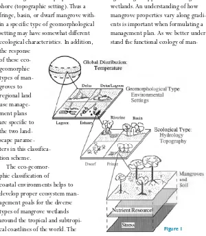
By Colin Field
I
n recent years, there have been detailed studies of the fauna, flora, ecology, hydrology, physiology and productivity of many different man-grove ecosystems but the discrete nature of these data makes the princi-pal factors controlling overall produc-tivity very difficult to identify. This sit-uation is, perhaps, not surprising given the heterogeneity of mangrove ecosys-tems and the lack of a single model that describes the way that they func-tion. Mangrove ecosystems are places where tides and coastal currents bring constant variation and where plants and animals have to adapt to changing chemical, physical and biological char-acteristics. Even simple analysis is diffi-cult because of the lack ofcomparable measuring techniques and a readily accessible data bank.
The question then arises as to the meaning of “restoration.” Several terms are used to describe efforts to rebuild disturbed ecosys-tems, including reclamation, rehabilitation, eco-develop-ment and restoration, and these are often used inter-changeably.
“Restoration” is used here as the act of bringing an ecosystem back, as close as possible, to its original condition, or renewing or bringing it back into use. In practice, restoration rarely means returning an ecosystem to its original condition.
Reasons for Restoration
Restoring a mangrove ecosystem implies that it has been altered or degraded in a way that conflicts with management or conservation objec-tives, leading to competition for land use. At times, though, it can arise from climatic impacts that have destroyed the natural vegetation. It is essential to define restoration goals as a first step,in order to identify the elements of the mangrove ecosystem which must be included and to provide a clear frame-work for operation and implementa-tion (Table 1). There are two main rea-sons for restoring mangrove ecosys-tems, although the boundaries between these are frequently unclear– conservation for ecosystem preserva-tion and restorapreserva-tion for sustainable uti-lization and protection of coastal areas.
I. E c o syste m Pr e se rvatio n
If the aim is to conserve an example of natural ecosystem, restoration will involve maintaining most ecological processes and preserving as much genetic diversity as possible. The best approach is probably to seek an undis-turbed area and to restrict utilization
and interference from external factors. If the area is truly pristine then it is likely that very little management will be required. If a mangrove forest is disturbed by logging, it is unlikely that it will regenerate to anything like its original state, as the mix of species, soil type, density of trees and numbers of animals will almost certainly change.
II. Su st ai n ab l e U se an d C o ast al
P r o te c tio n
In this case, the priority will be to maximize sustainable productivity. Less attention can be paid to restoring as much of the ecosystem as possible and more given to the cost benefit of the product. A critical question is how
much of the original mangrove ecosys-tem has to be restored to ensure sus-tained production. This demands fur-ther research on pristine and disturbed mangrove ecosystems. It has certainly not been established that maximizing biodiversity in restored mangrove ecosystems leads to maximum, or even optimal, sustainable yields. Further-more, the concept of “purpose-built” ecosystems may take on real value and there may be a goal of enhancing pro-ductivity without regard to how the restored system compares with the original one.
Restoration Approaches
A common approach to restoration is essentially that of classical land man-agement, with forestry or animalhus-bandry of a specialized kind. Successful restoration requires knowledge of the processes essential to developing and supporting the productivity of the sys-tem as a whole, rather than its parts. This is generally lacking for mangroves. If there is to be intensive and selective use of mangrove forests, then specialized knowledge needs to be acquired for plants and animals in areas such as genetics, nutrition, stocking procedures, disease control and harvesting. In turn, this knowledge needs to be supported by appropriate technology and suitable legislation.
Lugo (1988) describes four restora-tion activities, where the goal is sus-tainable use:
■Reduction of environmental stress
(fire, cutting, over-grazing).
■Adding materials (plants, animals,
water, fertilizer, soil).
■Accelerating or decelerating
ecosystem processes (encouraging nat-ural regeneration).
The Restoration of Mangrove Ecosystems
(continued page 12)
Table 1. Site characteristics to be considered when restoring a mangrove ecosystem
Stability of site Insulation Rate of siltation Exposure to wind Nature of soil Height of the water table Exposure to waves and Presence of pests
tidal currents (Acrostichum, barnacles, crabs)
Salinity of the soil water Availability of propagules Depth of tidal inundation Signs of natural regeneration Gradient of site Absence of debris
Availability of fresh water Cooperation from local
■Changing site conditions
(drain-age, shading).
Finally, restoration can be extremely expensive, not only because of the technical aspects, but also because land purchase and litigation may be involved.
Measuring Restoration
Success
Measuring the success of the restoration process is a challenge that is rarely recognized. If restored man-grove ecosystems are to be compared with naturally occurring ones, then comparative measurement of produc-tivity, movement of organic matter and organization of the food chain will have to be carried out. Additional problems are:
■An inability to define long-term
or genetic changes in populations that may preclude restoration to a known original condition.
■A lack of understanding of the
natural variability of an ecosystem and its recovery process.
■The often high cost of restoring
an ecosystem to something like its original state as opposed to the cre-ation of an alternative at substantially less cost.
Cairns and Buikema (1984) argue that an ecosystem’s response to a dis-turbance depends on three characteris-tics–its ability to resist change, to recover and its resilience to repeated disturbances. In the case of mangroves, there is only patchy information on these characteristics.
Conclusion
Sustainable development implies that an ecosystem can be manipulated,
exploited or disturbed without loss of integrity but there is often a reluctance among ecologists and conservationists to approve of such manipulation even though it may lead to enhanced pro-ductivity. Consequently, mangrove restoration has tended to concentrate on preservation of animal and plant species threatened with habitat loss. Mangrove restoration projects them-selves could help to supply some of the scientific knowledge that is currently lacking, if they are carried out with clear objectives under carefully con-trolled conditions and incorporate long-term monitoring. A high priority is to document the many restoration projects underway around the world and to make such information freely available.
For more information contact: Colin Field, University of Technology, Sydney, Australia.
Mangrove Replantation Project in Pakistan
By Najam Khurshid and Fayyaz Rasool
mangroves and getting them involved in the project. An on-site project officer was appointed who interacts directly with the community and constantly promotes the value of mangroves. Rapport with the local community has been established, and acceptance has been gained for the project.
In May 1995, in collaboration with the Baluchistan Forest and Wildlife Department, two nurseries were estab-lished, as experimental work had shown that of the three species found in the area, only Avicennia marina grows suc-cessfully if sown directly into the wild. Beds were prepared and pits dug, and seeds were held for germination. Ripe seeds which fall off the parent tree were collected and sown individu-ally in each bag in the nursery by the villagers, with women and children actively participating.
Seedlings have to be cared for and protected for 8-12 months until they are sufficiently mature to be planted out and subjected to tides and strong winds. Transplanting of the seedlings was completed and new seeds have been sown for transplantation next year.
If the pilot work goes well, a full afforestation program will be developed for Sonmiani, and as local communities increasingly recognize the benefits of such efforts, mangrove restoration pro-grams will be started elsewhere. With the development of this sense of “stew-ardship” for natural resources, WWF-Pakistan will then be able to expand the program to cover sustainable manage-ment of other marine and coastal resources.
For more information contact: Najam Khurshid, Conservation Direc-tor; or Fayyaz Rasool, Conservation Officer, W orld W ildlife Fund Pakistan, 12th Floor, Sidco Ave, Centre, 264, R.A. Lines, Karachi, Pakistan.
Restoration
(continued from page 11)
S
onmiani Bay on the Makran coast of Pakistan is surrounded by three villages: Sonmiani, Damb and Bhira. The mangroves around the Bay have been severely degraded by cutting and overgrazing. WWF-Pakistan is sup-porting a replanting project at Sonmiani where gaining the support and participation of the local people is a high priority.T
he extent of mangrove defor-estation for shrimp farming is unknown, but is thought to be substan-tial on a global scale. For example, in the Philippines, an estimated 50 per-cent (approximately 141,000 hectares {ha}) of mangrove loss can be traced to brackish water pond development and in Viet Nam over 102,000 ha of shrimp ponds were constructed in mangroves between 1983 and 1987. Much of the mangrove conversion has been rapid, unplanned and unmanaged, and many farms have proven to be unsustainable. Consequently many ponds have been left idle or abandoned, and farmers have developed new sites in an effort to maintain production. This presents a major challenge for both coastal resource managers and pond owners who have to address the question of what to do with unproduc-tive ponds.An indication of the frequency of abandonment can be gained from in-formation for Thailand. By 1989, about 22 percent of the farms in Samut Sakorn province had been abandoned, and a 1994 study noted that some 4,000-4,500 ha of ponds south of Bangkok have ceased production due to disease and are now largely derelict. An estimated 70-80 percent of ponds have been abandoned in Prachuap
Khiri Khan, with similar figures for the provinces of Songkhla and Si Thammarat. The Bangkok Post of February 20, 1995 reported that overall about 24 percent of shrimp farms in Thailand are being abandoned, and that each 1,000 ha of abandoned ponds equates to an economic loss of 80 thou-sand pounds sterling each year. Similarly, it has been recently estimat-ed that in some areas only 20 percent of farms are currently operational, and in other small producing areas, 100 percent of ponds may be inopera-tional.
Causes and
Consequences of
Abandonment
Ponds are left idle for a variety of reasons. For instance, declining envi-ronmental quality may cause an increased incidence of disease and has been widely cited as commonly caus-ing production failure. A variety of diseases have spread from one location to another. In Thailand these included Monodon baculovirus in 1988, the Yellow Head baculovirus in 1992 and, more recently, White Spot disease which is estimated to have been responsible for losses of 50-80 percent production during 1996. Other countries where disease has led to pond failure include India, the Philippines, Taiwan and Indonesia.
Potential acid sulfate soils (P.A.S.S.) exist in many mangrove soils and, as a result of the excavation and construc-tion of shrimp ponds, become oxidized and form actual acid sulfate soils
(A.A.S.S.) which release large quanti-ties of acid and toxic levels of iron and aluminum upon wetting. Research in Southeast Asia has revealed that acid, iron and aluminum are directly res-ponsible for fish and prawn losses and general low productivity. Although it is possible to culture shrimps in ponds in acid sulfate soils by adding lime and increasing water exchange, the tech-nology is not always available, and in Viet Nam the development of A.A.S.S. has led to pond abandonment. Other causes of pond failure or abandonment include improper site selection, poor construction methods, poor water quality and circulation, poor farming practices, a lack of post-larvae and/or broodstock, market constraints, and government policy or intervention.
The environmental conditions left after abandonment may be more sig-nificant in impeding rehabilitation of a pond than the original cause of failure. For instance, in Karnataka, India, hun-dreds of ponds are said to be aban-doned as a result of White Spot disease but the major obstacle to their rede-velopment is the prevalence of A.A.S.S.
which, if untreated, may persist for many years. The acidic water resulting from these soils can destroy food resources, displace biota, release toxic levels of aluminum, precipitate iron which smothers vegetation and
micro-Abandoned Shrimp Ponds:
Options for Mangrove Rehabilitation
By N. J. Stevenson and P. R. Burbridge
(continued page 14) Disused shrimp pond in Kumta, Karnataka, India. (Photo courtesy
of Jesmond Sammut, University of New South Wales, Sydney)
Table 1. Use of abandoned shrimp ponds in Samut Sakorn, Thailand
ha perent
Converted to traditional system
shrimp culture 1,173 33
Converted to salt farming 711 20
Converted to coconut plantations 248 7 Top soil sold for construction
purposes 248 7
Left idle 213 6
Unidentified 962 27
To t a l 3 , 555 h a 1 0 0
habitat, and alter the physical and chemical properties of the water (Sammut et al. in press). Consequently, acid-tolerant species may dominate and further impede restoration attempts.
Mangrove clearance, shrimp cultiva-tion and the abandonment of ponds may also alter soils in other ways including accelerating soil erosion by increasing surface run-off and inter-flow; decreasing soil water storage capacity; reducing biodiversity of soil fauna; altering the transport of sedi-ments, dissolved inorganic and organic constituents and principal nutrients; increasing levels of toxic chemicals; and depleting organic matter through leaching and mineralization.
Options for Rehabilitation
and Restoration
There are three basic options for dealing with abandoned ponds:
1. Rehabilitation for shrimp pro-duction;
2. Rehabilitation for other
sustain-able uses such as salt production or integrated aquaculture;
3. Restoration of the environmen-tal conditions within the ponds and surrounding area to a productive man-grove ecosystem.
The suitability of these options depends on the causes of failure of the pond operations and the conditions which remain in the pond after aban-donment. There are several successful
examples of the second option–con-version to other uses. In Thailand, large tracts of abandoned shrimp ponds in Samut Sakhorn have been converted to housing estates and industrial development (although such activities may not constitute “best use” options and
may have their own specific ecological impacts). Some aban-doned shrimp farms have been converted to salt farms or fish culture operations for sea bass and tilapia, and shrimp farms
located near main roads have sold top soil for construction projects (Table 1). The Department of Fisheries in Thailand has promoted cage culture of fish (including mullet and sea bass), blood cockles and mussels in aban-doned shrimp farms. However there have been some major problems, including lack of seed for blood cock-les, lack of suitable fish species for cage culture in idle ponds, lack of investment credit and the need for technology transfer related to aquacul-ture and mariculaquacul-ture.
There has been some success with using abandoned shrimp ponds for grouper culture in the Philippines and crab culture in Thailand, and it has been suggested that the abandoned ponds could be used for polychaete culture, integrated salt-artemia production or shrimp-salt production. Integrated shrimp culture may be the most attrac-tive option to farmers who have ceased shrimp production but still own or have the lease rights to the ponds. Aqua-sil-viculture could be used to facilitate the restoration of abandoned, unproduc-tive or denuded open areas to a pro-ductive condition, and might reduce mangrove replanting costs by provid-ing a local supply of propagules and minimizing transport costs.
Constraints to
Restoration and
Sustainable Use
The remediation of acid sulfate soils presents many problems, not least of which are the time required and the
costs involved. One treatment involves the deliberate oxidation of the acid-producing material (pyrite) and flushing out with brackish or fresh water. This reduces soil acidity but does not take into account the ecological impact of the acid leachate. In addition, successful replanting of aban-doned shrimp ponds may be severely constrained by increased erosion, the activation of acid sulfate soils, and the presence of shrimp culture related chemicals. Variable success rates have been achieved with different mangrove species in small scale experiments.
Additional constraints include the lack of technical expertise in general habitat restoration and an even greater lack of experience in restoration of unproductive shrimp ponds. Market forces and the preferences of the pond operators must also be considered when identifying potential alternative uses, and their economic feasibility. For example, a survey in Thailand showed that the primary aim of farm-ers with unproductive ponds is to start shrimp culture again (Table 2). Options which meet both the manage-ment objectives of coastal resource managers and those of the pond own-ers should be pursued.
Finally, there is the question of who bears the costs of redevelopment. Restoration of unproductive shrimp ponds to a productive mangrove ecosystem is very expensive, particu-larly if propagules are in short supply and if it is necessary to create a
Abandoned Shrimp
Ponds
(continued from page 13)
Table 2: Intentions of farmers who have abandoned their land
No. of farms percent
Return to shrimp culture 38 73.08
Culture fish (Seabass) 1 1.92
Make salt farm 4 7.69
Sell land 3 5.77
Leave the land 2 3.85
Other (Agriculture land, housing
and land for rent) 4 7.69
Total 52 100.00
(Source: NACA 1994 translated from Thai by Buntoon Srethasirote 1996 pers.comm.)
Excavation of shrimp pond in Potential Acid Sulphate Soils (PASS) in Kumta, Karnatake, India (Photo courtesy of Jesmond Sammut, University of New South Wales, Sydney)
By M. Rasolofoharinoro,
F. Blasco and J. Denis
A
quaculture in Madagascar’s Malagasy mangroves has provid-ed a boost to the local economy, but problems in the for m of mangrove destruction and increasing pollution threaten the area. A bibliographic and photographic analysis (aerial photos from 1992 and SPOT imagery from 1993) and field studies, however, sug-gest some solutions.National operators and foreign investors in Madagascar are increasing-ly exploiting the coast because of the depletion of forest, agricultural and pastoral areas. The Malagasy mangroves, covering some 400,000 hectares (ha), provide optimal condi-tions for aquaculture, par ticularly in estuaries and embayments.
The wester n coast of Madagascar could potentially produce 58,000 tons of crustaceans per year, but aquaculture is a still recent development. It star ted with a pilot hatchery project in 1990 at Nosy-Be, which was followed in 1993 by a shrimp far ming operation of over 3,995 ha, established by a fishery com-pany in Mahajamba Bay. A number of natural, social and economic factors have contributed to aquaculture’s success:
■The extensive salt-flat areas, called “tannes,” which occupy the middle and upper courses of channels of the Masokoenja and Marovoaikely Rivers. These are for med by the high spring-tide range of 3.5 meters, and are pro-tected by a screen of mangrove trees. The per manent flow over the tannes provides organic and mineral-enriched soft water, which helps to make the area a good nursery for many aquatic species, par ticularly shrimps and prawns.
■The clay-like texture of the tannes provides an imper meable substrate, favorable to shrimp-pond construction.
■The use of the bare tannes means that there is no need to clear vegeta-tion for ponds.
■The Mahajamba mangroves have been protected for many years, as they are considered inviolable and have been a factor in the social unity of local communities.
■There is a plentiful workforce for the aquaculture facility, though people had been forced to emigrate when a starch factory closed down, and land
and agricultural oppor tunities became scarcer.
■Some employment oppor tunities have been created by the aquaculture operation-cutting mangrove trees for timber, transpor t of motor-fuel, tool repairing and improvements to the local infrastructure.
■ There are business oppor tunities for collaborative effor ts by groups which specialize in oceanographic, marine and biochemical resources to produce marine products which must meet the strict industrial standards of the inter national market.
■The aquaculture facility provides foreign currency to the Malagasy econ-omy and per mits the impor t of feed, disinfection products and other items.
From 1993 to 1995, 644 ha were used for assay and exploitation of ponds, the shrimp processing plant and reception infrastructure. Eighty ponds
are situated in dry tannes, previously occupied by Salicornia pachys-tachia
(Chenopodiaceae), and are being protect-ed from erosion by herringbone wood-stakes work until the planted mangroves, Avicennia marina, have grown. It is an intensive aquaculture system. The ponds, which average over 0.5 ha, are equipped with water-pumps, filters and aerators, adapted to suit the diverse requirements of each stage in the growth of the shrimps (e.g. ar tificial feeding, water quality moni-toring). The repro-duction rate is rela-tively high (above 80 percent) and, since 1993, staggered crops have been pro-duced regularly. Methods in the process-ing plant are prepared, usprocess-ing perfected fittings and a research laboratory. This success provides encouragement for the continuation of shrimp far ming at other sites and for similar projects elsewhere
Aquaculture in Madagascar’s
Mahajamba Bay
(continued page 16)
Madagascar
(continued from page 15)
in the country.
Nevertheless, several environmental impacts are already being felt which threaten the facility:
1. Mangrove destruction is wide-spread, even in dense mangrove areas, as dikes and embankments have to be constructed.
2. Sensitive sites, notably silting zones, are being used which increase the extent of tannes.
3. The safety measures taken are not sufficient to prevent risks from natural disasters or disrupting flows (e.g., fill-ing up of channels, inundation).
4. Dredging is increasing water tur-bidity, as the current patterns are not taken into consideration; dredging on potential acid sulfate soils accelerates their acidification, and salts are rising to the surface, rich in chlorides and sulfates, forming a whitish powder. 5. Pollutants (e.g., waste-water, wastes of farming and processing, dis-infection products, engine oil) are degrading water-quality. Rising tem-peratures, oxygen saturation reduced to less than two percent, high salinity, weak flow of tides, abundance of whitish froths and foul smells are emitted by wastewater even after decanting.
6. Noise caused by pumps and ship-ping, and turbulence movements around ships can disturb the flora and fauna (e.g., juvenile fishes, seedlings growth, subsidence of banks).
7. The weak bearing capacity per unit of area of mangrove soils requires the widespread use of dikes and inten-sification of embankments to the detri-ment of the mangroves.
8. The aquaculture activity has
some flow-on effects endangering the mangrove ecosystem: for example, per-manent occupation, more cutting for timber, firewood, smoking of fish, col-lieries, more fishing and/or conversion of mangrove into rice fields.
Aquaculture may be a suitable land use for some less productive parts of the mangrove ecosystem, but better data are required to assess aquaculture work and impact to control environ-ment effects. Otherwise, the inade-quate legislation and the lack of access prevents effective control of the milieu.
At the national level, a policy for coastal facilities, notably aquaculture operations, is urgently needed. New legislation is also needed. The forest legislation, dating from 1930, covers mangroves but was formulated for ter-restrial forests. The legislation for aqua-culture is recent (1985), but is mainly concerned with fishing. In addition, there needs to be more effective enforcement of the legislation and pro-vision of the necessary enforcement personnel and methods of transport, as well as involvement of the local com-munities to avoid any conflict. Sensitive zones have to be defined and delineated with the collaboration of local commu-nities, and the number and types of occupation per site and the resort cal-endar must be respected. Replanting (particularly with Avicennia marina ) must be done and controlled, to ensure the regeneration of mangrove and the protecting of its ecosystem. Planning must include the treatment of pollu-tants (incineration and burial of wastes, complete treatment of waste-water before discharging into channels or rivers). An improved database on the mangrove ecosystem and the results of impact studies is needed, updated by
remote sensing.
At the regional level, infrastructure must be improved to reduce the occupation of mangroves, for example by constructing and maintaining roads in other areas, par-ticularly in agricultural and pastoral areas. In the same way, social equipment and land reliability in traditional spaces must be rehabilitated. Forestry should be encour-aged and the establishment of new opera-tions should be restricted to avoid increas-ing environmental impact. At the local level the topographic lines must be taken into account by all facilities, particularly creeks, channels favoring drainage, or for laying out dikes or banks. Imperatives for protecting mangroves include:
■Respect for current patterns in dredge
works.
■Control and survey of all intervention
in the mangrove (fishing, wood exploita-tion, salt extraction).
■Removal of cutting licenses and
clear-ing areas in the mangrove.
■Control and survey of navigation and
fuel transport.
Aquaculture is a good use of the tannes and promotes regional development by cre-ating local employment and improving infrastructure, but its future depends on better mitigation of the environmental impacts. The destruction of mangroves, falling banks, alteration of the quality of water, disorganization of the flow, and the acidification of the soils certainly endanger shrimp farming.
A database updated by remote sensing and an impact study will allow the
mangrove ecosystem to be surveyed and controlled.
For more information contact: M. Rasolofoharinoro, F. Blasco and J. Denis, Laboratoire d’Ecologie Terrestre, CNRS/ UPS, BP. 4403 - 31405 Toulouse CEDEX, France.
Abandoned Shrimp
Ponds
(continued from page 14)seedling nursery. Although it may be possible to create financial disincentives to prevent or limit future habitat destruc-tion (by making the costs of destroying or denuding a habitat match or exceed the
cost of keeping or replacing it), this would not speed the redevelopment of unproductive ponds. Consequently other means of catalyzing and funding rehabilitation or restoration activities must be found.
For more information contact: Peter
Burbridge, Centre for Tropical Coastal Management Studies, Department of Marine Sciences and Coastal
Majagual: The Tallest Mangroves
in the World
By Emilio Ochoa
M
ajagual is an estate in the north of Esmeraldas, the northern-most province of Ecuador. It lies in the estuary of the Cayapas-Santiago-Mataje Rivers, on the border withColombia, an area which encompasses almost 22,000 hectares (ha) of man-grove and some 50,000 inhabitants. Some of the tallest mangrove trees in the world are found here, reaching over 60 meters in height. Several of these are on private property and could be felled at any moment. The forest is mature and very dense, with very little light penetrating the foliage of the can-opy. Some of the trees are about 100 years old and, seen from the distance, appear as tall, thin columns.
The traditional uses of mangroves (charcoal, fuel wood, collection of shellfish and shrimps) gave way in recent years to the harvesting of large trees for posts and to clearing for shrimp pond development. The growth of both traditional and modern pres-sures is damaging the structure of the mangrove forest in such a way that its
fauna and flora is now declining at a rate faster than it can naturally recover. Timber harvesting brings in a revenue of 400,000 sucres/hectares(ha)/yr (10-15 m3/ha/yr) and some 500,000 crabs and mollusks are collected each week, with a value of about 5,000,000 sucres (US$1,500 approx.).
Part of the estate was bought by a company, Purocongo, and in 1993 shrimp aquaculture ponds were con-structed amidst major protests, suspi-cion and initial concern by the local community. Tension rose considerably when various NGOs and the press reported that the company had cut the mangroves to open a canal to bring in water. The Programa de Manejo de Recursos Costeros and the Fundacion Maldonado intervened and the compa-ny agreed to draw up an agreement with the community and authorities to develop its ponds and at the same time protect the mangroves. Majagual is now the site of a controversial experiment, so far successful, where shrimp farm-ers are learning to co-exist with m