J. SE Asian Appl. Geol., Jul–Dec 2013, Vol. 5(2), pp. 71–77
ESTIMATION OF THE GEOLOGICAL STRENGTH
INDEX SYSTEM FOR CAVITY LIMESTONE
LAYER IN QUARRY AREA, REMBANG,
CENTRAL JAVA PROVINCE, INDONESIA
R. Andy Erwin Wijaya*1,2, Dwikorita Karnawati2, Srijono2, and Wahyu Wilopo2
1Department of Mining Engineering, Sekolah Tinggi Teknologi Nasional, Indonesia
2Department of Geological Engineering, Faculty of Engineering, Universitas Gadjah Mada, Indonesia
Abstract
Limestone mining needs a good mine design which is safe for the environment. Mine design is deter-mined by the rock mass quality. The rock mass qual-ity in each mine location is not necessary the same depending on the geological conditions. The research area is located in limestone quarry of Sale District, Rembang Regency, Center Java Province-Indonesia. In the limestone quarry area, there is cavity zone which consists of cavity limestone layer at the wall of quarry bench. This cavity layer in limestone quarry has occurred by solution process. The cavity layer zone is a potentially weak zone which has caused bench failures in the limestone quarry area. The ob-jective of this research is to analyze the rock mass quality in the cavity limestone layer using Geologi-cal Strength Index (GSI) system. Final result of the research is a rock mass characterization, specifically for cavity limestone layer.
Keywords: geological strength index, limestone, cavity layer
1 Introduction
Limestone mining inSale District, Rembang Re-gency, Center Java Province-Indonesia uses the quarry method, which is one of the surface mine methods. To apply this method, it must
*Corresponding author: R.A.E. WIJAYA, Department
of Mining Engineering, Sekolah Tinggi Teknologi Na-sional, Indonesia. E-mail: [email protected]
have mine design i.e. benchs with a safe slope at the wall (Hustrulid and Kuchta, 1995). Re-liable estimates of the strength and deforma-tion characteristics of rock masses are required for almost any form of analysis used for the mine design of surface excavations specifically for bench of limestone quarry. Hoek and Brown (1980a, 1980b) proposed a method to estimate the strength of jointed rock masses, based on an assessment of the interlocking of rock blocks and the condition of the surfaces between these blocks. This method was modified over the years in order to meet the needs of users who applied it to problems that were not consid-ered when the original criterion was developed (Hoek 1983, Hoek and Brown 1988). The appli-cation of the method to very poor quality rock masses required further changes (Hoek, Wood, and Shah, 1992) which led to the development of a new classification called the Geological Strength Index (GSI) system (Hoek, 1994; Hoek, Kaiser, and Bawden, 1995; Hoek and Brown, 1997; Hoek, Marinos, and Benissi, 1998). The GSI system was also modified by Sonmez and Ulusay (1999). The GSI system is used in this research to determine rock mass quality of the surface mine, particularly limestone quarry.
WIJAYAet al.
Figure 1: Location of the research area (red box).
2 Geological condition
Rembang Zone is part of the Northern East Java Basin that runs from Tuban eastwards through Lamongan, Gresik, and almost the entire is-land of Madura. The morphology of the Rem-bang Zone can be divided into three morpho-logical units, namely lowland, undulating hills, and steep hills. Based on the geological map of Jatirogo (Figure 2), the research area is cov-ered by Paciran Formation, which consists of massive limestone and dolomitic limestone (Si-tumorang, et al., 1992). The rocks in the Rem-bang Zone have undergone intensive folding and faulting resulting in anticlines and syn-clines.
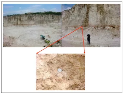
3 Solution cavity layer in limestone quarry
In some parts of the limestone quarry area, there is cavity zone, which is formed by solu-tion of limestone, at the wall of quarry bench (Figure 3). The cavity zone is a potentially weak zone of bench failure. The cavity zone is from
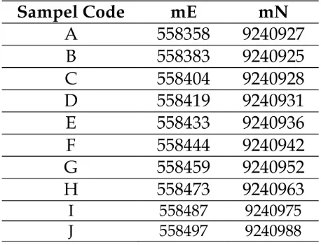
Table 1: Coordinates of cavity limestone layer outcrop observation.
ESTIMATION OF THE GEOLOGICAL STRENGTH INDEX SYSTEM FOR CAVITY LIMESTONE LAYER
Figure 2: Geological map of the research area.
WIJAYAet al.
ESTIMATION OF THE GEOLOGICAL STRENGTH INDEX SYSTEM FOR CAVITY LIMESTONE LAYER
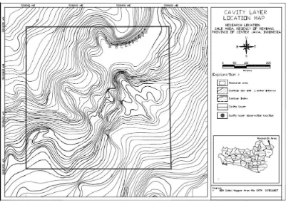
Figure 5: Cavity layer map.
4 GSI estimation for rock mass quality of cavity zone in limestone quarry
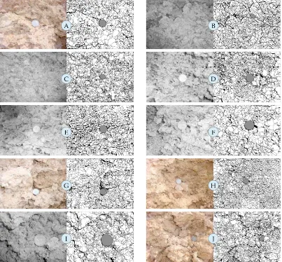
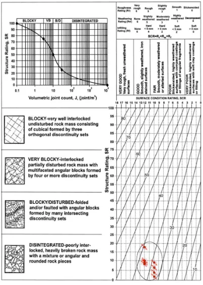
Identification of rock mass characteristic has been proposed to determine rock mass quality. This system provides a method for estimating the reduction in rock mass strength for differ-ent geological conditions as iddiffer-entified by field observations. Classification of rock mass qual-ity based on the GSI, combined 2 (two) main pa-rameters, i.e. structure rating (SR), in terms of blockiness and surface condition rating (SCR), in term of roughness, weathering and infill-ing. Based on outcrop observations in lime-stone quarry area, all structure condition of the cavity limestone layer are described by the term disintegrated as the rock masses are poorly in-terlocked, heavily broken rock mass with a mix-ture or angular and rounded rock pieces (see Figure 4). To obtain the structure rating (SR), volumetric joint count (Jv) is calculated as fol-low:
Jv: Joint volumetric count
M: Amount of discontinuity
L: Scanline (m)
The surface condition rating (SCR) was esti-mated from the input parameters (e.g. rough-ness, weathering and infilling). The total rating for surface condition rating (SCR) is obtained using the following equation:
SCR=Rr+Rw+R f (2)
Rr: rating for roughness
Rw: rating for weathering
Rf : rating for infilling
WIJAYAet al.
ESTIMATION OF THE GEOLOGICAL STRENGTH INDEX SYSTEM FOR CAVITY LIMESTONE LAYER
5 Conclusions
The cavity limestone layer in the study area consist of very small blocks with rough surface, slightly to moderately weathered and soft in-filling materials. The scores of GSI estimation for rock mass quality of cavity layer zone in the limestone quarry are between 32 and 39, in-dicating a poor rock mass quality. The cavity layer zone is a potential weak zone which has caused bench failure in the limestone quarry area.
References
Hoek E. and Brown E.T. 1980. Underground ex-cavations in rock, p. 527. London, Instn Min. Metall.
Hoek E. Strength of jointed rock masses, 1983. 23rd Rankine Lecture. Géotechnique 3(3), 187-223.
Hoek E. and Brown E.T. 1988 The Hoek-Brown failure criterion – a 1988 update. In Rock Engineering for Underground Excavations, Proc. 15th Canadian Rock Mech. Symp. (Edited by Curran J.C.), 31-38. Toronto, Dept. Civil Engineering, University of Toronto. Hoek E., Wood D. and Shah S. 1992. A
mod-ified Hoek-Brown criterion for jointed rock masses. Proc. Rock Characterization, Symp. Int. Soc. Rock Mech.: Eurock ‘92, (Edited by Hudson J.A.), 209-214. London, Brit. Geotech. Soc.
Hoek E. 1994. Strength of rock and rock masses, ISRM News Journal, 2(2), 4-16.
Hoek E., Kaiser P.K. and Bawden W.F. 1995. Support of underground excavations in hard rock. p. 215. Rotterdam, Balkema.
Hoek, E. and Brown, E.T. 1997. Practical esti-mates or rock mass strength. Int. J. Rock Mech. & Mining Sci. & Geomechanics Ab-stracts. 34(8), 1165-1186.
Hoek, E., Marinos, P. and Benissi, M. 1998. Ap-plicability of the Geological Strength Index (GSI) classification for very weak and sheared rock masses. The case of the Athens Schist Formation. Bull. Engg. Geol. Env. 57(2), 151-160.
Hustrulid, W., M. Kuchta, 1995, Open Pit Mine Planning and Design, Volume 1 Fundamen-tal, A.A. Balkema, Roterdam, Brookfield. Situmorang, R. L., Smit, R., dan Van Vessem, E.
J., (1992), Peta Geologi Lembar Jatirogo, Jawa, 1509 – 2, Skala 1:100.000, Pusat Penelitian dan Pengembangan Geologi, Badan Geologi, De-partemen Energi dan Sumberdaya Mineral, Bandung.
Sonmez, H. and Ulusay, R. 1999. Modifications to Geological Strength Index (GSI) and Their Applicability to stability of Slopes. Int. J. Rock Mech. Min. Sci., Vol. 36, p. 743-760. PT. Sinar Asia Fortuna, 2013, Rembang