5
STRUCTURE, HYDROGEOLOGY, AND THE GEOTHERMAL
SYSTEM OF MOUNT UNGARAN AREA, CENTRAL JAVA,
INDONESIA
Sari B. Kusumayudha1, Andriyanto P. Markam2, Basuki Rahmat3 UPN “Veteran” , Jl SWK 104 Yogyakarta, Indoesia.
Email: [email protected]
ABSTRACT
Indonesia is well known as a country of volcanoes. There are hundreds active and dying volcanoes, one of which is namely Mount Ungaran. It is a Pleistocene age volcano, located in the Semarang region, Central Java Province. In the present time the volcano is identified being in its post volcanism stage. Some observable fact related to the stage of the volcano is there has been no more volcanic eruption record for a thousand year. In contrary, there exist fumaroles and sulfuric hot steam through fissure on the flank of the volcano. The geologic structures obtained at the surrounding area are reverse faults, strike slip faults, and normal faults. On the other hand, the hydrogeologic system is compiled of fractured complex aquifer system, containing volcanic breccias, sandstones, and lava deposits of andesitic to basaltic composition. Due to the high density of fractures, cracks, and faults, the aquifers are able to transmit surface water and groundwater down to contact with such hot plutonic bodies in the volcanic environment to perform geothermal system. This geothermal system is expressed by the occurrence of side and fissure sulfuric fumaroles eruption. Therefore it can be stated that structures and hydrogeologic condition play important role to the occurrence of the geothermal system in the study area.
Introduction
Mount Ungaran is located at Central Java province, belonging to the Semarang region, Indonesia. The volcano is Pleistocene (about 1 to 1.8 million years) age, and in post volcanism phase, indicated by the existence of fumaroles on its side vent. Ancient Mount Ungaran volcanism was the source of Notopuro Formation, comprises of andesitic to basaltic breccias, sandstones and agglomerates. Geothermal system is generally influenced by geologic structure, and hydrogeologic condition. Therefore, based on the rationales mentioned above, this paper is intended to assess the geologic structures and hydrogeologic condition those control the geothermal system of Mount Ungaran environment.
6 Method applied in order to complete the objectives of this study is geologic and hydrogeologic mapping, geologic structural and hydrochemistry analyses. Some rock and groundwater samples were taken for either in situ or laboratories testing.
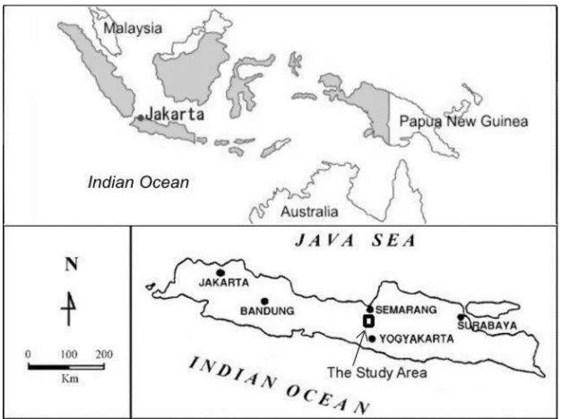
Figure 1. The location map of the study area
Geology
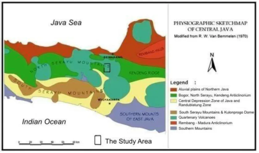
Van Bemmelen (1949) divided the physiography of the Central Java into several zone, respectively from the north to the south are alluvial plain of Northern Java, North Serayu Anticlynorium, South Serayu Mountains, Central Depression and Quaternary Volcanoes Zone, and Southern Mountains. The study area that is situated on the southeastern slope of Mount Ungaran, physiographically includes in the North Serayu Mountains (Figure 2). The Ungaran volcano stands on the eastern most edge of uplifted mountains, and separates North Serayu Mountains in the west from Kendeng Ridge in the east (East Java). Both the North Serayu and Kendeng Mountains are folded ridges, built of predominantly plastic sedimentary rocks of Tertiary Neocene ages (Van Bemmelen, 1949). Because of occupying such foot slopes of a volcano, landforms in the study area are generally expressing hills and wavy planes.
7 1949). The youngest lithology of the study area is alluvial deposits, consists of unconsolidated sediments of clay, granule, pebble, cobble, to boulder grain sizes. The alluvial have been produced from fluvial sedimentation of some rivers, such as River Panjang, River Garang, and River Santritulung.
Figure 2. The Physiographic map of Central Java (Van Bemmelen, 1949)
Structural Geology and Hydrogeology
The study area shows a complex geologic structure of folds and faults. Formation of Tertiary period is strongly folded, while litologic unit of Quaternary period is in general dissected by faults. In spite of being controlled by regional tectonic regime of Java island during Tertiary to Quaternary period, the geologic structures in the southeastern slope of Mount Ungaran is also influenced by local gravitational tectonic processes of Pleistocene to Holocene (Van Bemmelen, 1949). The Quaternary gravitational phenomenon created the collapse of Ungaran volcano, and reactivated some faults those already sliced the plastic formations underlain by the massive volcanic deposits of Notopuro Formation (Van Bemmelen, 1949).
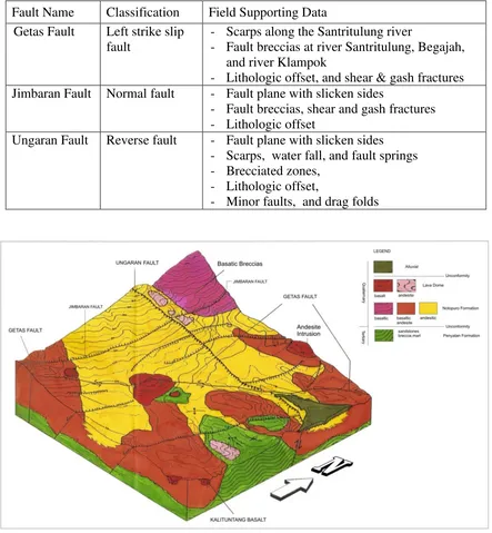
8 Table 1. Field supporting data to fault classification of the study area
Fault Name Classification Field Supporting Data Getas Fault Left strike slip
fault
- Scarps along the Santritulung river
- Fault breccias at river Santritulung, Begajah, and river Klampok
- Lithologic offset, and shear & gash fractures Jimbaran Fault Normal fault - Fault plane with slicken sides
- Fault breccias, shear and gash fractures - Lithologic offset
Ungaran Fault Reverse fault - Fault plane with slicken sides - Scarps, water fall, and fault springs - Brecciated zones,
- Lithologic offset,
- Minor faults, and drag folds
Figure 3. Geologic block diagram of the southeastern slope of Mount Ungaran (Markam, 1998 revised by Kusumayudha et.al, 2011)
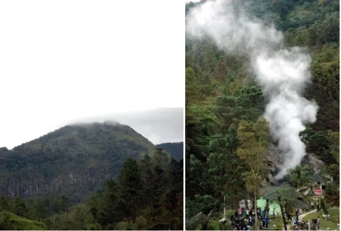
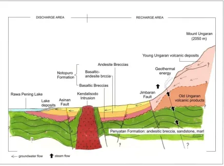
9 subsidence (Van Bemmelen, 1949, Zen, 1969, vide Zen, et.al, 1983). Impact of this collapse, magma extruded out to the surface forming some lava domes around the summit of the volcano (Figure 5a.). Despite of the existence of ring faults, there are radial faults which play as the vent of side or flank eruptions. Up to now, fumaroles, sulfuric hot steam and geyser extrude from the flank vent as geothermal energy potency (Figure 5b.).
Figure 4. Schematic block diagram of Ungaran volcano–tectonic (Van Bemmelen, 1949)
10 The hydrogeologic system of Ungaran area is built by aquifers comprises of volcanic deposits especially andesitic breccias, lava, and sandstone, predominantly forming fissure type of water bearing formation. In this system, Penyatan formation plays as the basement. Based on their stratigraphic position, Ungaran aquifers can be classified into unconfined and semi confined aquifers. Groundwater dynamics in the Ungaran aquifer is very complex, because it is conducted by crack and intergranular porosity systems combination. Under the hydraulic gradient, groundwater moves in general relatively from west to east direction by complex diffuse and cracked flow type.
Recharge zone occupies almost all parts, while the discharge zone lay on the eastern parts of the study area. There are many springs, and some of them are containing sulfur of moderately high concentration, and relatively high temperature. The existences of some hot and sulfuric springs show that the volcanism of Ungaran in the present time is progressing for post volcanism stage. Figure 6 displays the hydrogeologic conceptual model that is controlling the geothermal system of the southeastern slope of Mount Ungaran.
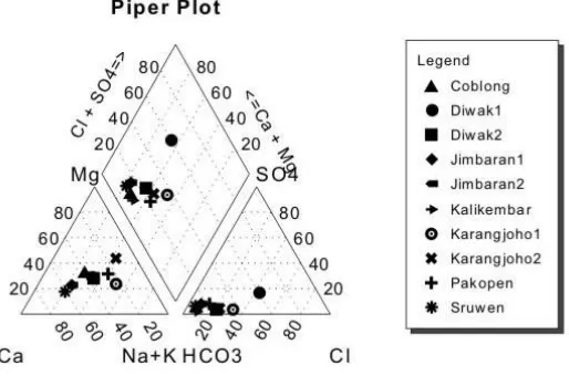
11 The properties and groundwater chemistry of the aquifers are shown in the Table 2 and Table 3. The data were obtained from field measurements, field sampling, and laboratory testing. Result from hydrochemistry analysis using Aquachem software show that groundwater of Ungaran aquifer belongs to various water types. Based on cation content, it can be classified into calcium dominant water, on the other hand according to anion content the water includes in bicarbonate water, although some samples indicating chloride water (See Table 3 and Figure 7, the Piper plot of groundwater chemistry).
Table 2. Properties of the Ungaran aquifers
Hydraulic Conductivity
Table 3. Groundwater chemistry of the Ungaran aquifers
Sample
12 Geothermal System of Mount Ungaran
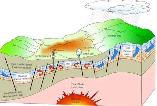
The earth anatomy from the outer to the inner is composed of crust, mantle, and core respectively. It owns and yields natural heat. Increase of the temperature layers with depth toward the earth core is called geothermal. The temperature of the geothermal has been resultedfrom heat residue of the initial earth material, and decay of radioactive compounds. The rate of the temperature change in the earth crust per km deep is known as geothermal gradient. Geothermal gradient causes the melting rocks to form such very hot and melted materials in the earth mantle. When hot and melted materials of the earth mantle rise to intrude the crust, it is called magma. If the magma extrude the surface, it becomes change its name to lava.
When water from the earth surface infiltrate subsurface penetrating soil layers reaching the saturated zones, it will forms groundwater. Due to high permeability of the rock formation and particular favorable condition, the groundwater will gravitate down to enter deeper formations, contact to such a high temperature rock body. The water then will be heated, changing its phase to be steam. When the surrounding rock formations are fissured intensively by joints and cracks, the condition will be able to function as a regulation for the steam out flowing from its traps. The steam mixed with such volcanic gases is potentially flushed up and out of the land surface, known as fumaroles that can be geothermal energy resource. The model of geothermal system is shown in the Figure 8 bellow.
Figure 8. Geothermal system model (http://www.indotoplist.com/info)
On the south flank of Mount Ungaran, i.e. Gedongsongo area, there is fumarole through fissures, composed of water vapor and such gases as CO2, H2S, H2, and CH4
(Wahyudi, 2006), with temperature of about 85oC. Water samples taken from Gedongsongo in general show very low ph < 4.0. This high acidity of the water is caused by geochemical reaction of water with some gasses such as CO2, and Sulfur. Source of the erupted steam is
13 including the southeastern slope parts of the volcano which strongly controlled by cracks, fissures, and faults.
Due to the influence of geologic condition as has been discussed earlier, there are weak zones performed from the existence of reverse Ungaran Fault, strike slip Getas Fault, Jimbaran Fault, and other normal faults with all of their secondary order structures of joints and fractures. The weak zones cause the aquifer more permeable. The existence of such a caprock makes the steam accumulated, causing its volume and pressure increase. Lithology that able to function as a caprock is clay or marl. As it was mentioned above, there are marl layers in Penyatan formation. When there is crack system able to be the regulator, the steam will be sprayed out, known as fumaroles. The geothermal potency of Mount Ungaran is assumed to be sustainable, because it is supported by the relatively high precipitation in the surrounding area, i.e. 2,247 mm/year average (www.esdm.go.id).
Conclusion
Based on the analysis and assessment written above, the conclusions are as the following: 1. Geology of the study area is composed of Tertiary Penyatan Formation, unconformably
overlain by Pliopleistocene Notopuro Formation. Penyatan Formation comprises of sandstone, breccias, and marl, Notopuro formation consists of andesitic to basaltic breccias, lavas, volcanic sandstones, and tuffs. The formations are intruded by andesites and basalts.
2. Geologic structures in the study area are folds and faults. The folds exist in Penyatan Formation, while the faults cut up Notopuro Formation. The three main faults are Ungaran reverse fault, Getas left strike slip fault, and Jimbaran normal fault.
3. The hydrogeologic system of the Ungaran southeastern slope is built of complex fissures aquifer system composed of volcanic rocks of Mount Ungaran. Types of groundwater are variation of Ca-Mg-Na-HCO3, Na-Ca-Mg-HCO3-Cl, Ca-Na-HCO3, and Ca-Na-Mg-Cl. The structural hydrogeologic system let groundwater of the surrounding area to contact with magmatic and plutonic bodies of the volcanic environments to perform geothermal system.
4. The geothermal system of Mount Ungaran southeastern slope is expressed as flank and fissure fumaroles eruption. The fumaroles consist of water vapor, CO2, H2S, H2, and
CH4 with 85oC temperature.
References
Billing, M.P., 1979, Structural Geology, 3rd ed., Prentice Hall of India, New Delhi, 606 p
Budiardjo, B., Nugroho M, Budihardi, 1997, Resource Characteristics of the Ungaran Field, Central Java Indonesia, Proc. Seminar of Human Resources of Indonesian Geologists, UPN “Veteran” Yogyakarta, p9
Domenico, P. A. & Schwartz, F. W., 1990, Physical and Chemical Hydrogeology, John Wiley and Sons
14 Hem, J. D., 1985, Study and Interpretation of the Chemical Characteristics of Natural
Water, USGS Water Supply Paper 2254
Kusumayudha, S. B.,1993, Groundwater Geochemistry of Mount Merapi's Southern Slope Area,Java, Indonesia, Master of Science Thesis, AIT, Bangkok, unpublished, 239 p.
Kusumayudha, S.B. & Pratiknyo P., 2001, Detecting the existence of groundwater discharge in the fractured volcanic area. Majalah Geologi Indonesia, Vol 16 No 2, p 83 - 91
Markam, A. P., 1998, “Geologi dan Studi Aplikasi Sistem Informasi Hidrogeologi pada
Endapan Vulkanik Kuarter Sistem Akifer Ungaran daerah Jimbaran – Ungaran dan
Sekitarnya, Kecamatan Ungaran, Kabupaten Semarang, Jawa Tengah – Indonesia”,
Thesis, UPN “Veteran” Yogyakarta, Unpublished, 206 p.
Matthess, G., 1982, The Properties of Groundwater, John Wiley $ Sons Publishers, New York, 406 p.
Pertamina, 1976, “Stratigrafi Zona Bogor – Serayu Utara Daerah Semarang Baratdaya Jawa Tengah”, Divisi Eksplorsi Migas, Jakarta, Indonesia, unpublished, 45 p.
Samuel , L. & Genevraye, 1972, Geology of the Kendemg Zone (Central and East java), Proc. 1st Annual Convention of IPA, Jakarta, Indonesia,
Samuel L., Yanto, R., Sumantri, Fx, Suyanto, Sudiono, A., Syhbudin, A., 1995, Indonesia Geothermal Reserves and Resources, Pertamina, Jakarta, 45 p
Todd, D.K., 1980, Groundwater Hydrology, 2nd edition, John Wiley & Sons, New York., 535 p.
Van Bemmelen, R.W., 1949, The Geology of Indonesia, Vol IA, Martinus Nijhoff, The Hague, 792 p.
Wahyudi, 2006, “Kajian Potensi panasbumi dan rekomendasi Pemanfaatannya pada daerah Prospek Gunungapi Ungaran, Jawa Tengah, Berkala MIPA, Vol 16 (1), Januari 2006, p 41 - 48
Zen, M. T., M.A. Syarif, S.H. Simatupang, G. Yuniarto,1983, Tektogenesa Gaya Berat dan Daur Magma Sepanjang Deretan Gunungapi Ungaran – Merapi di Jawa Tengah, Proc IAGI Annual Convention, Yogyakarta p 76 - 85
http://www.esdm.go.id
http://www.indotoplist.com/info