Assessment of forest resources in Brunei
Darussalam: A Remote Sensing solution
Kazimierz Becek
Abstract
This report assesses statistical data on the forest resources of Brunei Darussalam.
The author conducted a careful audit of several publications on forest resources of
Brunei Darussalam, and found that in some instances there are huge discrepancies
in the reported forest cover in Brunei. The lack of regular comprehensive
inventories and an erroneous linear extrapolation model parameter, i.e. the
country’s annual deforestation rate, used to estimate the net loss of forest cover are
the major
contributory
factors. As a rapid way to rectify these disparities in the forest cover, a novel Remote Sensing method is suggested. Also outlined is apreliminary feasibility analysis to carry out an immediate forest inventory using the
proposed Remote Sensing method and recent datasets in the custody of the Survey
Department. It is suggested that this very necessary update of the forest resources
assessment of Brunei Darussalam may be carried out by local experts for a fraction
of the cost of a comprehensive forest resources assessment.
Key words: Brunei Darussalam, Forest Resources Assessment, FAO, Forestry Department, Survey Department, Remote Sensing, LiDAR.
1.0
Introduction
Reliable data on the forest resources of a country are needed not only for
well-informed management of forests, but also to fulfil international obligations
regarding the supply of accurate data on forest resources in the country concerned.
The latter is one of the most important single pieces of data for studies on, and
mitigation of, global warming. To assess the available CO2 sink capacity of global
forests, an accurate and global view of forest resources is required. This knowledge
is also necessary to serve many other purposes, including policy planning on a
local to global scale, and to ensure sustainable forest resource management from
the regional and global vantage points.
Reliable data on forest resources requires an effective system for data acquisition,
processing, storing, reporting and dissemination that is efficiently operated by the
authority in charge of forestry in the country. Nowadays, such systems are in place
and operational almost everywhere in the world. Local and international research
organisations such as the International Union of Forest Research Organisations
(IUFRO) (http://www.iufro.org/), the World Wildlife Fund (WWFII)
(http://www.wwf.org/) and others strive to improve the quality, accuracy and
reliability of the methods and results of forest resource assessments. The progress
in this area, especially in recent years, has been substantial, thanks to the
development of Remote Sensing (RS) technologies and techniques that allow for
the rapid and accurate data capture required for a forest inventory (Becek 2011).
Also, improvements in terrestrial data capture and management, including the
Global Navigation Satellite System (GNSS) and Geographic Information Systems
(GIS), help to gather data on local forest matters such as wildfires, infestation of
insects and diseases, logging concession areas, illegal logging events, forest
rehabilitation and conservation areas and plantations.
A careful study of the Bruneian data on the percentage of forest cover submitted to
the FAO (Food and Agriculture Organisation), published by the UN (United
Nations), as well as newspaper publications and the results of research on the forest
significant discrepancies between these sources of data regarding the forest
resources of Brunei Darussalam. A null hypothesis is that the lack of decadal forest
inventories in Brunei (FAO 2010b), and also the very limited GIS and Remote
Sensing capabilities of the Forestry Department of Brunei (FAO 2010b), a lack of
data exchange between other agencies in the country (FAO 2005) and the ‘too
optimistic’ deforestation rate used by the Forestry Department are to blame for
these discrepancies.
To this end, the Heart of Borneo (HoB) (http://heartofborneo.org/) initiative, one of
the most important cross-boundary ecological projects in the world, involving the
ecological systems of Brunei, Indonesia and Malaysia, may not be adequately
serviced because of a lack of proper monitoring and assessment instruments. As a
leading and prestigious project, HoB requires a current set of data, not only for the
size of the area declared for it, but also for any changes in the permanent and the
phenomenological vegetation cover, the land use and the anthropogenic
infrastructure, including transportation and dwellings. This type of detailed and
current data on HoB will only be available if functional data acquisition systems
are in place, mainly remote sensing systems, but also regular reports from
stakeholders such as the Ministry of Development, the Ministry of Industry and
Primary Resources and the Ministry of Defence. In addition, a dedicated
geographic information system (GIS) would facilitate data processing, analysis,
data collection and information development.
Taking into account the availability of the Light Detection and Ranging (LiDAR)
survey of the country and high-resolution aerial photography, it would be possible
to carry out a high-precision forest resource assessment in Brunei in a few months.
Assuming also a cost-free data exchange between the Forestry Department and the
Survey Department – agencies of the Government of Brunei Darussalam – such a
project could be completed for a fraction of the cost of a forest inventory
The technical, organisational and other aspects of such a project are examined in
this paper with the hope that highlighting the lack of current data on forest
resources in the country will assist the relevant authorities in the country in their
decision making in order to embark on this well overdue forest inventory.
2.0
What is a forest?
According to the FAO (FAO 2004), there are at least 250 definitions of a forest.
This large number of attempts to define a forest may be justified by virtue of the
seemingly countless types of forests found on our planet. Putting aside quite
common and natural disagreements among scientists, there is also much cynical
disregard for the universal forest protection so as to propose definitions of forest to
satisfy certain economic interests of some countries (oil palm plantations).
Nevertheless, after many years of searching for the most universal forest definition,
the following is currently recognised by the FAO as the definition of a forest:
‘Land spanning more than 0.5 hectares with trees higher than 5 meters and a canopy cover of more than 10 per cent, or trees able to reach these thresholds in situ. It does not include land that is predominantly under agricultural or urban land use’ (FAO 2004).
It is important to notice that this definition requires that at least 10% of the area
must be under tree canopy to be recognised as a forest. This implies that a logged
out (clear-cut) forest cannot be called a forest anymore. This 10% threshold
warrants that a minimum ecological value of a forest is preserved after a logging
operation. In fact, the whole sense of this definition is embedded in the recognition
(for the first time by many people) of the value of a forest as a unique ecological
system, which is extremely important for ensuring climate stability and
maintaining the biodiversity of our planet.
It appears that the Forestry Department of Brunei Darussalam accepts the above
definition of forest. However, some doubts may arise because of the following
‘Brunei’s definition of forest cover includes the total amount of virgin forests and logged-over forests’.
This statement clearly indicates that a ‘logged-over’ forest is also considered as a
forest, which is contrary to the FAO’s definition of forest and against any
ecological sense. Also, common sense is violated if one attempts to count an area
as a forest after all the trees have been cut down.
Certainly, both examples are definitions of a forest, but the latter, in particular,
seems to ignore the fact that a forest is much more than just a collection of trees.
For example, a ‘forest’ without trees does not provide shelter for animals.
3.0
Forest resource assessment as a tool of trade of
forest departments
Forest resources assessments or forest inventories are performed on a regular basis
by most of the countries around the world. The main goal of a forest inventory is to
determine a number of parameters that characterise forest resources in a qualitative
and quantitative manner. These parameters allow for assessing the magnitude of
the impact of the natural and anthropogenic factors on forest resources. For
example, the extent of forest cover depends on the intensity of logging activities,
conversion of forest into agricultural and urban and industrial areas, depletion of
forest due to diseases, fires and other factors. A forest inventory aims also at
capturing many different characteristics of a forest. To explain this, one must
understand that a forest is an extremely complicated ecological system, which
provides livelihood not only to found species, but also it has always been a place
where people have obtained food, medicines, building materials and safety.
Commercial benefits can also be derived from a forest. Accordingly, the timber
productivity of a forest must be assessed from this perspective. The knowledge of
how much timber is in a specific forest and its annual rate of growth of timber is
necessary to estimate the maximum allowable level of timber extraction to
Major inventories are usually conducted every 10 years. However, reports on forest
resources are compiled annually by updating the results of the major inventory
with data taken from various sources, including internal forestry department
statistics, reports of logging companies, the emergency services department and a
few other departments dealing with land matters. Depending on the country
concerned, these departments may include the Town and Country Planning
Department, Land Department, Department of Public Works, Department of
Agriculture, Department of Natural Resources (minerals), Department of
Communications and Transportation, Fire and Rescue Department, Survey
Department and others. A level of development and functionality of the National
Spatial Data Infrastructure (NSDI) (Ali 2009) in the country of concern is a single
predictor allowing for assessing how successful the spatial data sharing between
the government agencies is. In the case of Brunei, the Brunei Darussalam Spatial
Data Infrastructure (BDSDI) was formally started in 2008.
The most comprehensive, global data source on forests is the Global Forest
Resource Assessment report (GFRA) (http://www.fao.org/forestry/fra/en/). The
GFRA has been published every five to ten years since 1946 by the Food and
Agriculture Organisation (FAO) of the United Nations (UN), and is compiled from
the reports of members’ countries. A great deal of work has been done to adopt
common standards of reporting of the national data for the compilation of the
GFRA. The latest GFRA report was published in 2010. The following subjects are
presented in GFRA reports (FAO 2010):
1. extent of forest resources and their contribution to the global carbon
cycle;
2. forest health and vitality;
3. forest biological diversity;
4. productive functions of forests;
6. socio-economic functions of forests, and
7. the legal, policy and institutional framework related to forests.
Besides global tables, the GFRA report includes also country reports that were
used to compile the GFRA. Brunei Darussalam has submitted its reports to the
FAO since the country became a member of the UN, that is, since 21 September
1984.
4.0
New technologies in assessing forest resources
The simplest, very effective, but time-consuming method of forest inventory is
photo interpretation of aerial or satellite imagery. This method requires an
experienced photo interpreter who is able to delineate boundaries between different
forest types. Once this step is completed, the area of the forest-type regions are
calculated and summarised. The quality of this method depends on the scale of the
imagery and the level of experience of the interpreter.
Modern data acquisition methods for the purpose of forest inventories are entirely
based on the technology known as Remote Sensing (RS). RS relies on
multispectral images that are captured from space from orbiting satellites. The
multispectral images from these satellites are freely available from vendors around
the world. The price of the images depends on the sharpness (smaller pixel more
expensive image) of the image and on the number of spectral bands in the image. A
good-quality image may be purchased for a few thousand Brunei dollars. The
multispectral image is processed by a sophisticated computer program for the
purpose of highlighting similar pixels. These groups of pixels are referred to as
classes. It is assumed that a class represents a certain type of feature on the surface
of the earth, for instance, soil, water or a particular forest type. The whole process
is to the highest degree automated and
requires
minimal human assistance. One of the important obstacles in deploying this forest inventory method is the persistentcloud cover over Brunei. The clouds make capturing an image that would be
Another, recently developed method (Becek, 2011) is based on radar satellite data.
The tremendous advantage of this method relies on the fact that the radar waves are
able to penetrate cloud cover. Thus, the data acquisition may be carried out
independently of the weather. This method allows for automatic identification of
all areas covered by vegetation. A very important advantage of this method is its
ability to estimate forest density, which may be correlated with the health status of
the forest.
A version of this method is the LiDAR survey, which is performed from an
aircraft. The LiDAR produces a dense ‘cloud’ of points covering the surface of the
earth. These 3D points are used to calculate the height of vegetation. In other
words, the LiDAR survey can be used to identify points (and areas) at which
vegetation is present. Therefore, the areas under vegetation can be easily identified.
The above methods deliver a significant part of the data for a comprehensive forest
inventory without assistance from any additional information from any other
agency. This is important in cases where the data sharing culture among
government agencies is still underdeveloped.
5.0
Forest resource assessments in Brunei
The Forestry Department of Brunei Darussalam has conducted only one national
forest resources assessment so far. As a result of this study, forest type maps at
1:50,000 and 1:200,000 were produced (FAO 2005). The Anderson & Marsden
(Forestry Consultants) Company from Singapore conducted this inventory using
the photo interpretation method (outlined above). Two sets of aerial photographs
were used, consisting of colour photos taken during the 1975/76 period, and black
and white photos taken in the 1981/82 period. The approximate scale of both
photos was 1:25,000. Extensive ground truthing was also conducted to support the
photo interpretation. The final report from this inventory was published in 1984
Since this comprehensive inventory, no further follow-up inventory has been
carried out. Thus, all statistics of Brunei forestry have been based on this sole data
source. To provide for annual loss of forest cover, probably due exclusively to
permitted
logging activities (about 100,000 m3 per annum), a figure of 2,000 hahas been assumed.
The Forestry Department of Brunei Darussalam observes the ‘Cut one, plant four’
policy, which means that one lost tree must be replaced by four planted trees.
Unfortunately, the author was not able to source any statistics on how many trees
are successfully planted by the Forestry Department annually. However, assuming
that just one tree out of four was successfully established, this would mean that the
net loss of forest is null. However, this policy can only be successfully
implemented where the forest land is not permanently converted into some
non-forest usage.
Forest is lost not only due to logging, but also due to land conversion processes.
The magnitude of loss of forest cover in Brunei Darussalam due to land conversion
from forest to agricultural or urban land use is unknown. This fact and a
justification of it were expressed by the Forestry Department in an official
submission to FAO in the following way:
‘Due to lack of study on specific fields and some of data under the jurisdiction of other government agencies in Brunei Darussalam, the [Forestry] Department is not able to give some detailed information as requested. Some steps for reporting tables [in GFRA] as stated in the guidelines are not relevant due to the limited source of data’. (FAO 2005)
This admission is quite staggering and bold at the same time. It should trigger an
immediate reaction from the relevant authorities. Some other disturbing facts
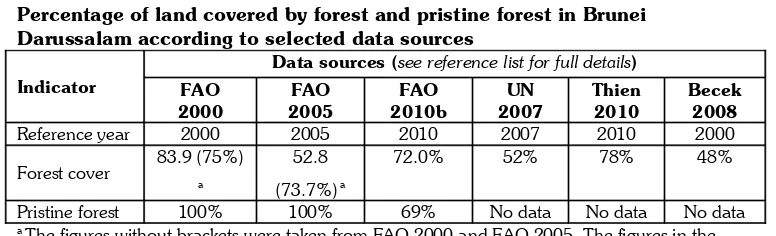
regarding the basic statistics on forest cover in Brunei Darussalam are collected in
Table 1.
Percentage of land covered by forest and pristine forest in Brunei Darussalam according to selected data sources
Indicator
Data sources (see reference list for full details) FAO
Pristine forest 100% 100% 69% No data No data No data
a The figures without brackets were taken from FAO 2000 and FAO 2005. The figures in the
brackets were taken from FAO 2010b as corrected figures for the years 2000 and 2005.
The data shown in Table 1 indicate that the forest cover in 2000 varied between
48% and 83.9%. In 2005 the same indicator ranged from 52.8% and 73.7% and in
2010 it was listed as 72% and 78%. Note that the forest cover increased over 5
years by
approximately
5%. Even larger discrepancies wereidentified
for the percentage of the pristine forest in the total forest cover. Note that in 2000 and2005 this indicator was listed as 100%. But in 2010 the percentage of pristine
forest was only 69%.
Some more light on these discrepancies may be provided from the already
referenced interview with the Deputy Director of Forestry Department (Thien
2010), in which he stated that:
‘In 2005, we calculated that we still have 76 per cent of Brunei’s forest cover’.
Besides the fact that the title of the article reports that about 78% of the land mass
of the country is under forest versus the 76% stated in the above statement, it is
important to note that this figure in FAO 2005a was quoted as 52.8% (Table 3, p.
191). Also, Brunei Darussalam has been listed as the number one country in the
world with the highest percentage of primary forest (100%) (ibid. p. 42). Both
figures seem to have been subsequently modified by the Forestry Department.
Hence, in the FAO 2010a report the forest cover and the primary forest areas are
Realising that there are problems with the reported figures on the forest cover of
Brunei, the Government of Japan in 2008 offered to fund a project to reconcile
these discrepancies. For unknown reasons, this offer has not been accepted by the
Forestry Department of Brunei Darussalam.
A proper monitoring of forest resources of the country should not be done merely
for statistical purposes. Forest monitoring may be carried out through forest
inventories or simply by inspecting free satellite data available on the Internet
(Google Earth). Forest monitoring may be used, for example, to assess the
implementation of the Brunei Selective Felling System (FAO 2010). The system
should ensure the integrity of the residual forest stands and that sufficient forest
canopy cover remains after trees have been extracted. Figure 1 demonstrates that in
at least one concession forest area, the selective logging system is violated.
Figure 1.
A fragment of a logging concession in the western part of Brunei. The clear-cut logging is evident (reddish areas). On the left is clearly visible pristine forest. On the right are the remains of a forest logged out some time ago. Only a few trees were saved. The low vegetation is probably some kind of shrubs – no trees. The geographic centre of the image is: φ = 4o
24’ 03” N, λ = 114o
6.0
Feasibility of an update of forest resource
assessment in Brunei
The Survey Department, Ministry of Development of Brunei Darussalam, is in
charge of providing basic spatial information, which includes the production and
updating of a range of maps (http://www.survey.gov.bn/index.htm). The Survey
Department is not in charge of developing thematic maps or inventories, including
geological, historical and forest maps. Thus, the Forestry Department is responsible
for preparation of forest maps and forest inventories. However, the Survey
Department may assist in providing the most recent data that can be used to
Towards the end of 2010, a Canadian subcontractor delivered to the Survey
Department two data sets of superior quality covering the whole country. There is
no doubt that this fact is a remarkable moment in the history of the Survey
Department and also this country. Never before
has such high quality data
been captured for the whole of Brunei. These data sets are a seamless mosaic of colouraerial photographs (http://www.rtbnews.rtb.gov.bn/?
c=newsDetail&news_id=16115). The photographs were geometrically corrected,
which is necessary for them to be used for mapping purposes. The smallest image
element (pixel) represents a 19 cm by 19 cm square on the ground, which may be
compared to the 61 cm by 61 cm of the sharpest images available on Google
Earth®. Such high-resolution images allow for precise identification of tree species
and even the trees’ health condition. The second data set delivered is a set of
elevation data of the earth’s surface and also the elevation of objects above it. With
an astonishing density of one point per square metre, this elevation data set allows
for precise modelling of the country’s topography. It also provides data on the
elevation of trees; tree density may also be derived from this data set.
Both data sets are extremely useful
in preparing
an update of the forest inventory in Brunei Darussalam, which is already 30 years old. The resulting inventorywould provide not only an update in terms of the actual forest cover, but it would
also deliver several other
characteristics, including
forest density, which is a proxy for forest health.A few additional benefits a forest inventory carried out based on the
above-mentioned data sets would include the following:
-
the inventory would be extremely inexpensive (probably up to B$100,000);-
the duration of the inventory including the map production should not belonger than six months;
-
the inventory would not requireany field work to be performed
;-
the inventory can be made by the experts who are already in this country;-
the societal benefits of such a project being carried out in Brunei would beenormous in terms of training provided to the staff of the Forestry
Department and also any individuals involved.
7.0
Conclusions
The need for an update of the forest resources assessment has been justified by
pointing out several dramatic discrepancies in the forest cover of Brunei
Darussalam as reported by the Forestry Department of Brunei Darussalam. A few
reasons for these discrepancies are:
•
a lack of regular forest inventories;•
a lack of data sharing agreements between the departments (non-existence of NSDI); and•
a lack of a functional Geographic Information System for handling and reporting data on forest resources.Brunei Darussalam has joined Indonesia and Malaysia in their efforts to protect the
precious and unique forest and biodiversity of Borneo. The Heart of Borneo (HoB)
initiative has already been well recognised around the world as a brilliant example
of cross-boundary collaboration to protect an endangered tropical forest. An active
and sensible participation in HoB would require from all sides a full awareness of
what is happening in the forests under all three jurisdictions. However,
comprehensive knowledge about a forest can only be acquired through regular
forest inventories and proper record-keeping practises. This demand for
comprehensive knowledge of the natural environment has also been implicitly
expressed in Brunei’s National Vision, known as Wawasan 2035
(http://www.bedb.com.bn/why_wawasan2035.html). One of the strategies lauded
Modern remote sensing methods have been suggested as a way to overcome the
obstacles in conducting periodic forest inventories in Brunei Darussalam, using
traditional methods. Remote sensing methods allow for accurate monitoring and
assessment of the forest resources of the entire country and can also provide much
more detailed information than the traditional sample-based method. In addition,
costs involved in purchasing the required remote sensing data are many times
lower than those for the traditional method. The cost factor has also been gradually
improving as a result of the development of unmanned air vehicles (UAV), which
are significantly less expensive than the manned aircraft. Deploying UAVs on
missions to collect forest data is far simpler, logistically, than using manned
aircraft (no air traffic control permits required, etc).
However, a proper business model in the relevant authority must be
implemented prior to adoption of modern forest resource assessment
methods. Some deficiencies in the Forestry Department’s business model
have recently been identified (Soon, 2011). These include inadequate
funding and insufficient human resources. Indeed, this article will help
towards a comprehensive review of the Forestry Department’s business
model, to achieve the desired quality of the data available on the country’s
forest resources. It is also important to strengthen collaboration between the
Forestry Department and other agencies in sharing data and human
resources, in training and in using local expertise wherever possible to
gradually achieve self-sufficiency in performing the tasks assigned to the
Forestry Department.
REFERENCES
Ali, J. 2009, ‘The Challenges in the Implementation of Brunei Darussalam Spatial
Data Infrastructure (BSDI)’, Kertas Kerja, Symposium Sempena 100 Tahun
Pentadbiran Tanah Moden Negara Brunei Darussalam, pp. 17, viewed 11-12 Nov.
2009, viewed 15 July 2011, <www.tanah.gov.bn/Symposium/Hj Jamil Hj Ali.
Anderson & Marsden 1984, Brunei Forest Resources and Strategic Planning Study. Final Report, the Government of Brunei Darussalam, vol. 1.
Becek, K. 2008, ‘Development of a Vegetation Density Map of Brunei
Darussalam’. Proceedings of the MapAsia 2008 Conference, Kuala Lumpur, Malaysia.
Becek, K. 2011, Biomass Representation in Synthetic Aperture Radar Dataset’, LAP Lambert Academic Publishing, Saarbrücken, Germany.
FAO 2004, Global Forest Resources Assessment Update 2005; Terms and Definitions (Final Version), FAO, United Nations, Rome, Paper - 83/E.
FAO 2005, Global Forest Resources Assessment 200’, Forestry Department, FAO of the UN, viewed 15 July 2011, <http://www.fao.org/forestry/fra/fra2005/en/>.
FAO 2010a, Global Forest Resources Assessment 2010, Forestry Department,
FAO of the UN, viewed 15 July 2011,
<http://www.fao.org/forestry/fra/fra2010/en/>.
FAO 2010b, Global Forest Resources Assessment 2010, Country Report, Brunei Darussalam, Forestry Department, FAO of the UN, viewed 15 July 2011, <http://www.fao.org/docrep/013/al466E/al466E.pdf>.
Soon, J. Y. K. 2011.
Forest Management in Brunei Darussalam: Assessment ofPrinciples and Policies and Feasible Forest Resources Assessment Tool. MA Thesis, Universiti Brunei Darussalam.
Thien, R. 2010, ‘Brunei still has 78% green cover. UN’s deforestation claims
UN 2007, Brunei Darussalam, UN Data, World Statistics Pocketbook, UN Statistics Division, viewed 15 July 2011, <http://data.un.org/CountryProfile.aspx?