IJNMT, Vol. V, No. 1 | June 2018 30
ISSN 2355-0082
The Design of Mobile Indoor Robot Guidance
System
Dhanny Kurniawan Haryanto
1, Kanisius Karyono
2, Samuel Hutagalung
3Computer Engineering, Universitas Multimedia Nusantara, Scientia Garden, Jl. Boulevard Gading Serpong, Tangerang, Indonesia
1[email protected] 2[email protected] 3[email protected]
Received on September 25th, 2017 Accepted on June 8th, 2018
Abstract—The mobile indoor robot guidance system is a mobile robot which can assist users to find the desired disabled user and the user which is unfamiliar with the environment or the map. There is also potential usage inside the shopping mall or the big office spaces with the capability of displaying the advertisement during guidance process. This work deploys robot guidance system using geo-magnetic and Wifi methods for Indoor Positioning System (IPS). Although DC motors can generate interference to the magnetic sensor, the proper shields are adequate for the system. The metal shields for the DC motor can minimize the deviation from 6.41n T or about 16.74% for non-shielding motors to 2.86 n T or about 10.56%. Based on this research, mobile indoor robot guidance system can be implemented using various methods of IPS including geo-magnetic.
Index Terms—mobile robot, indoor positioning system (IPS), Wifi multilateration, geo-magnetic positioning, disabled user
I. INTRODUCTION
The mobile indoor robot guidance system is a mobile robot which can assist users to find the desired position or location indoor or inside particular shed where Global Position System (GPS) failed to perform. Unlike the GPS assisted positioning/ guidance, indoor guidance system has unique parameters especially for non-expert user [1, 2]. This system has to work under an invisible path and narrow area of movement unlike the road assistance GPS. The non-expert users can find the desired position faster with minimal learning curve. This kind of system will be useful to be used in large shopping malls, factories, offices and public places. This system will also give better accessibility support for the physically disabled people. Another benefit from indoor navigation system for disabled people is for giving the abilities to be independent. The system helps to make their lives easy without any external aid [3].
There are several applications for Indoor Positioning System developed for smartphone users. Not all users can easily use the system. Elderly and disabled person might face difficulties when using smartphone-based indoor positioning system. To resolve this issue, robot guidance is needed to assist them for direction and telling them where they are.
This system needs Indoor Positioning System (IPS) to update their location. There are several choices in implementing an indoor positioning system, such as magnetic [4, 5, 10], wireless fidelity (WiFi)
31 IJNMT, Vol. V, No. 1 | June 2018
ISSN 2355-0082
for indoor positioning system. This research use Earth’s magnetic field and WiFi to determine the latitude and longitude which represent the robot position on the map.
B. Units Location Name and Waypoint
Robot guidance not only work based on the latitude and longitude position. In order to interact with its user, the robot must have an idea of the location name it is located at and destination to guide users. Location name is known by comparing the distance between robot's position and the closest locations in the database. This referencing procedure help the user to simplify the position information. The same methods also applied to the location finding. The user is allowed to specify the waypoint to the target position. The waypoint can use the closest location to the predefined position in the database.
C. Location Information by Voice
The user interface / experience can be upgraded by giving the capability to receive location information by voice. This feature can be added using existing voice processing function provided by the operating system or additional voice processing function. This function is usually paired by voice command function. In this system, the voice command function can be beneficial for the visually impaired user to give command on where the user wants to go.
III. MOBILE INDOOR ROBOT GUIDANCE SYSTEM
DESIGN
A. Database Design
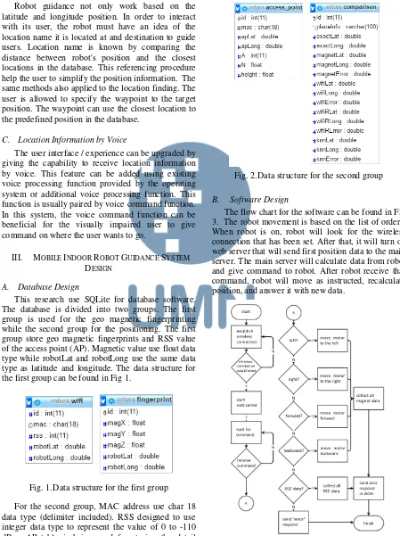
This research use SQLite for database software. The database is divided into two groups. The first group is used for the geo magnetic fingerprinting while the second group for the positioning. The first group store geo magnetic fingerprints and RSS value of the access point (AP). Magnetic value use float data type while robotLat and robotLong use the same data type as latitude and longitude. The data structure for the first group can be found in Fig 1.
Fig. 1.Data structure for the first group For the second group, MAC address use char 18 data type (delimiter included). RSS designed to use integer data type to represent the value of 0 to -110 dBm. AP table is being used for storing the detail
reference of each Access Point. Comparison table is added to link between position generated in geo magnetic method and Wifi method. Placeinfo is added to store the name of the location. The data structure for the second group can be found in Fig 2
Fig. 2.Data structure for the second group
B. Software Design
IJNMT, Vol. V, No. 1 | June 2018 32
ISSN 2355-0082
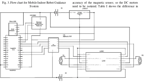
Fig. 3.Flow chart for Mobile Indoor Robot Guidance System
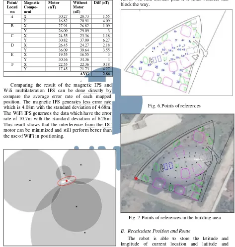
C. Hardware Design
Robot’s hardware consists of the components as follows:
ESP8266 NodeMCU
GY-273 HMC5883L Module / digital compass
DC motor and gearbox
H-Bridge Motor Driver L293D
Logic Level Converter (LLC) and regulator L7805CV
Power supply/battery The schematic can be found in Fig 4.
IV. THE IMPLEMENTATION,RESULT AND
DISCUSSION
A. Earth’s Magnetic Field
Magnet has three orthogonal strength (X, Y, and Z), total field strength (F), and two angles (D and I) [11]. X, Y, and Z component are being used to build fingerprint data. The robot compare sensor readings with the fingerprint to determine location.
The constraint of using earth’s magnetic field is the magnetic field interference from robot part. This research also measures the effect of the usage of DC motors to the reading in magnetic sensor. The magnetic field from DC motors can affect the
accuracy of the magnetic sensor, so the DC motors need to be isolated. Table I shows the difference in magnetic sensor readings between the robot which use DC motors and with no motors for comparison. The average difference is 6.41nT or about 16.74%.
TABLE I. DCMOTOR EFFECT AGAINTS HC5883LSENSOR READING
Point/ Locati on
Magnetic Compo-nent
Motors (nT)
Without Motors (nT)
Diff (nT)
A X 53.27 47.18 6.09
Y -13.64 -12.18 1.46
B X 54.45 45.91 8.54
Y -10.27 -14.27 4
C X 50.91 43.27 7.64
Y -29 -35.27 6.27
D X 53.27 44.36 8.91
Y -29.55 -32.18 2.63
E X -23.55 -31 7.45
Y -69.18 -60.27 8.91
F X -25.36 -33.45 8.09
Y -67.16 -60.27 6.89
AVG 6.41
Then the proper metal shields are installed in the DC motors to minimize the effect of interference. Table II shows the sensor readings between robots that used DC motors equipped with shield and without motors. It had an average difference result of 2.86nT or about 10.56%.
B. Wireless Fidelity
Robot also use received signal strength from WiFi to determine location points with multilateration [12, 13]. In Multilateration, access point (AP) location point is very important, because multilateration is calculated based on the position of three or more detected AP as in Fig. 5.
33 IJNMT, Vol. V, No. 1 | June 2018
ISSN 2355-0082
C. Mapping
This research uses 32 points of references for making sure that the results are correct. These points are considered as geo referencing for this research. The positions of the points are shown in Fig 6 and 7.
TABLE II. DCMOTOR WITH SHIELD AGAINTS
HC5883LSENSOR READING
Point/ Locati on
Magnetic Compo-nent
Motor (nT)
Without Motor (nT)
Diff (nT)
A X 30.27 28.73 1.55
Y 16.82 20.91 4.09
B X 27.91 26.82 1.09
Y 26.09 29.09 3
C X 24.55 23.36 1.18
Y 30.82 37.09 6.27
D X 26.45 24.27 2.18
Y 36.09 39.64 3.55
E X 19.55 16.55 3
Y 30.36 34.36 4
F X 22.55 22.36 0.18
Y 17.45 21.73 4.27
AVG 2.86
Comparing the result of the magnetic IPS and Wifi multilateration IPS can be done directly by compare the average error rate of each mapped position. The magnetic IPS generates less error rate which is 4.08m with the standard deviation of 4.68m. The WiFi IPS generates the data which have the error rate of 10.7m with the standard deviation of 6.26m. This result shows that the interference from the DC motor can be minimized and still perform better than the use of WiFi in positioning.
Fig. 5.Multilateration [14]
The data then compared to the geo referencing and then converted to distance in meter. The value of 1m is equal to 0.0000091 degrees in latitude and longitude.
V. ADDITIONAL FEATURES
Some features can be added to make the mobile indoor positioning system performs better.
A. Obstacle Avoidance
Robot equipped with ultrasonic sensor (HCSR04) to avoid obstacle in all of the edges of the robot. Robot will find another path if it finds obstacle that block the way.
Fig. 6.Points of references
Fig. 7.Points of references in the building area
B. Recalculate Position and Route
The robot is able to store the latitude and longitude of current location and latitude and longitude of the destination. When the robot moves, system can recalculate the route to the destination. This approach can minimize the dependency to the preset waypoint data in the system.
VI. CONCLUSION
IJNMT, Vol. V, No. 1 | June 2018 34
ISSN 2355-0082
position or location indoor or inside particular shed where Global Position System (GPS) failed to perform. Robot guidance system has many features in order to make the system useful for all of the users including the disabled users. Robot can be implemented using various methods of IPS. At this work, both magnetic and WiFi are used for guidance. The proper metal shields are installed in the DC motors to minimize the effect of interference. This approach can minimize the deviation from 6.41nT or about 16.74% to 2.86nT or about 10.56%.
REFERENCES
[1] Jevtic, G. Doisy, Y. Parmet and Yael Edan, “Comparison of
Interaction Modalities for Mobile Indoor Robot Guidance: Direct Physical Interaction, Person Following, and Pointing
Control”, IEEE Transactions on Human Machine-Systems,
Vol 45. No 6, 2015, pp 2168-2291
[2] Shwetak N. Patel, Julie A. Kientz, Sidhant Gupta, “Studying the Use and Utility of an Indoor Location Tracking System for Non-experts”, International Conference on Pervasive Computing Pervasive 2010: Pervasive Computing,, Springer-Verlag Berlin Heidelberg, 2010, pp 228-245
[3] Ruquia Mirza, Ayesha Tehseen, A. V Joshi Kumar, “An indoor navigation approach to aid the physically disabled people”, 2012 International Conference on Computing, Electronics and Electrical Technologies (ICCEET), India, 2012
[4] R. W. Permadi, M. Irmina and K. Karyono, "Android Based Indoor Navigation Application using Earth‟s Magnetic Field
Pattern," in Applied Electromagnetic Technology (AEMT), Tangerang, 2014.
[5] IndoorAtlas, "What Is Indoor Positioning Systems (IPS),"
IndoorAtlas, [Online]. Available:
http://www.indooratlas.com/how-it-works/. [Accessed 30 December 2016].
[6] R. B. Mulia, "Indoor Positioning Menggunakan Wireless LAN", Binus University theses, 2012 .
[7] A. Bekkelien, "Bluetooth Indoor Positioning," Master theses, University of Geneva, 2012.
[8] Blaz, "Indoor Positioning Systems based on BLE Beacons – Basics," 13 Maret 2015. [Online]. Available: https://locatify.com/blog/indoor-positioning-systems-ble-beacons/. [Accessed 31 December 2016].
[9] S. S. Saab and Z. S. Nakad, "A Standalone RFID Indoor Positioning System Using Passive Tags," IEEE TRANSACTIONS ON INDUSTRIAL ELECTRONICS, vol. 58, 2011.
[10] J. Chung, M. Donahoe, C. Schmandt, I.-J. Kim1, P. Razavai and M. Wiseman, "INDOOR LOCATION SENSING USING GEO-MAGNETISM," MIT Media Laboratory, ACM, 2011. [11] N. R. Canada, "Magnetic components," 14 April 2015.
[Online]. Available:
http://geomag.nrcan.gc.ca/mag_fld/comp-en.php. [Accessed 7 September 2016].
[12] Essamik, "BeaconLocalizationApp," 6 Maret 2016. [Online]. Available:
https://github.com/essamik/BeaconLocalizationApp. [Accessed 1 January 2017].