Bogor, 16 September 2008
The Governor Of NAD Province
in Banda Aceh
Subject: Recommendation on Several Demo Sites for Coastal Ecosystem
Rehabilitation After Tsunami
Dear Mr. Governor,
Since October 2005, through the Green Coast Project (funded by Oxfam-Novib),
Wetlands International Indonesia Programme (WIIP) in cooperation with WWF
Indonesia has facilitated 31 local NGOs and 29 Independent-Community Groups in
conducting coastal ecosystem rehabilitation after the tsunami disaster in Aceh-Nias. Up
to August 2008, more than 1000 hectares of coastal areas have been rehabilitated (with
an average plant survival rate of around 83% or 1.54 million of the 1.85 million
seedlings planted) with mangrove and coastal plants in Aceh and Nias. In addition, we
have also facilitated some efforts at coral reef protection, especially in Sabang.
The Green Coast Project comprises 4 (four) major activities: (1) coastal
ecosystem rehabilitation; (2) the development of alternative, environmentally friendly
means of livelihood; (3) the creation of village regulations that support the coastal
ecosystem rehabilitation efforts; and (4) environmental education campaign.
In total, the Green Coast Project has been carried out at 70 coastal locations: 54
were completed during Phase I (October 2005 to March 2007) and a further 16 begun in
Phase II (April 2007 to March 2009). Each location has its own unique characteristics in
terms of its ecosystem and the community’s means of livelihood. Based on WIIP’s
bio-physical and socio-economic study of these locations, we can identify some that have
important ecological as well as economic values that can be managed by the community
along with the other stakeholders as a sustainable Demo Site. Besides that, some
locations even have good potential for
eco-tourism
and
environmental education
, and
should therefore be promoted.
We realize that the Green Coast activities conducted in NAD and Nias are still
far from perfect. Therefore, we recommend that the Provincial Government and District
Government take follow-up actions so that the activities we have initiated can continue
to improve, provide benefits and be sustained, or even be a model for other coastal
locations in NAD/Nias and elsewhere in Indonesia.
In view of this and also of the fact that the Green Coast Project in NAD and Nias
will close in March 2009, we would like to propose that certain demo sites resulting
from Green Coast activities (attached), in particular those having important ecological
and economic values for the community, should:
•
receive official written acknowledgement from the NAD and Nias Provincial
Governments of the values and benefits these sites provide for the environment
and community, and that this be widely announced (please determine the most
effective way of delivering this information);
•
receive support that enables them to continue in existence and be properly
maintained, so that they do not function like other facilities that can bring
disdvantages to the environment and community (if possible, allocate some fund,
for example in Regional Budgeting);
•
be optimally utilised as venues for eco-tourism and as a mode of environmental
education for the community (including government officers, NGOs, research
boards, universities, school students, etc).
We do hope that the NAD and Nias governments can take the follow-up actions
proposed. To strengthen the proposal (and if required), we would be happy to make a
presentation of the results of our studies of these 11 locations in front of the NAD and
Nias governments.
On behalf of Wetlands International Indonesia Programme and the Local NGOs
involved in the Green Coast Project, we thank you very much for the cooperation from
the NAD and Nias governments as well as the directions from BRR.
It is our hope that this proposal can be followed up.
I Nyoman N. Suryadiputra
Coordinator of Green Coast Project for Indonesia
Copies to :
Assistent of Aceh on Development and Economics, NAD Governor Office
Chief of Regional Development Planning Board of NAD Province
Head of Environmental Impact Control Board of NAD Province
Head of Rehabilitation and Reconstruction Board – Aceh and Nias
Chief of National Development Planning Board in Jakarta
Ministry of the Environment in Jakarta
Head of Marine and Fishery Office of NAD Province
Head of BP-DAS NAD
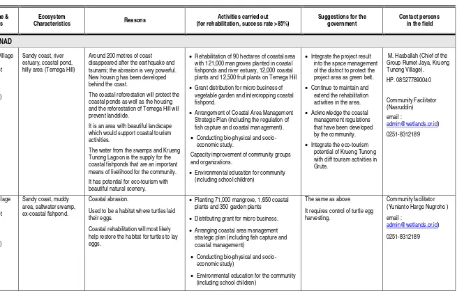
Table : List of Proposed Demo Sites* for Coastal Rehabilitation, Activities carried, Suggestions to government, and Details of contact persons in the field.
No Location Name & Coordinates
Ecosystem
Characteristics Reasons
Activities carried out (for rehabilitation, success rate >85%)
Suggestions for the government
Contact persons in the field
Aceh Jaya District – NAD
1 Krueng Tunong Village Jaya Sub-district Aceh Jaya District
5° 6' 43.56" (N) 95° 18' 43.27" (E)
Sandy coast, river estuary, coastal pond, hilly area (Temega Hill)
Around 200 metres of coast disappeared after the earthquake and tsunami; the abrasion is very powerful. New housing has been developed behind the coast.
The coastal reforestation will protect the coastal ponds as well as the housing and the reforestation of Temega Hill will prevent landslide.
It is an area with beautiful landscape which would support coastal tourism activities.
The water from the swamps and Krueng Tunong Lagoon is the supply for the coastal fishponds that are an important means of livelihood for the community. It has potential for eco-tourism with beautiful natural scenery.
• Rehabilitation of 90 hectares of coastal area with 121,000 mangroves planted in coastal fishponds and river estuary, 12,000 coastal plants and 12,500 fruit plants on Temega Hill
• Grant distribution for micro business of vegetable garden and intercropping coastal fishpond.
• Arrangement of Coastal Area Management Strategic Plan (including the regulation of fish capture and coastal management).
• Conducting bio-physical and socio-economic study.
Capacity improvement of community groups and organizations.
• Environmental education for community (including school children)
• Integrate the project result into the space management of the district to protect the project area as green belt.
• Continue to maintain and extend the rehabilitation activities in the area.
• Acknowledge the coastal management regulations that have been developed by the community.
• Integrate the eco-tourism potential of Krueng Tunong with cliff tourism activities in Grute.
M. Hasballah (Chief of the Group Rumet Jaya, Krueng Tunong Village). HP. 085277890040 Community Facilitator (Nasruddin) email : [email protected]) 0251-8312189
2 Ceunamprong Village Jaya Sub-district Aceh Jaya District
4° 58' 38.24" (N) 95° 22' 38.42" (E)
Sandy coast, muddy area, saltwater swamp, ex-coastal fishpond.
Coastal abrasion.
Used to be a habitat where turtles laid their eggs.
Coastal rehabilitation will most likely help restore the habitat for turtles to lay eggs.
• Planting 71,000 mangrove, 1,650 coastal plants and 350 garden plants
• Distributing grant for micro business.
• Arranging coastal area management strategic plan (including fish capture and coastal management)
• Conducting bio-physical and socio-economic study)
• Environmental education for the community (including school children)
The same as above
It requires control of turtle egg harvesting.
Community facilitator (Yunianto Hargo Nugroho )
email :
No Location Name & Coordinates
Ecosystem
Characteristics Reasons
Activities carried out (for rehabilitation, success rate >85%)
Suggestions for the government
Contact persons in the field
3 Keude Ungah Village Jaya Sub-disrict Aceh Jaya District
5° 0' 34.52" (N) 95° 22' 8.04" (E)
River estuary, muddy area and saltwater swamp (used to be rice field)
Housing area developed on buried ex-rice field needs to be protected from sea water abrasion and intrusion.
It is one example of the combination of coastal ecosystem recovery that occurs naturally (single species, sonneratia) and non-naturally (multispecies, various kinds of mangrove).
• Planting 70,000 mangrove, 9,650 coastal plants and 350 garden plants.
• Distributing grants for livestock breeding & tempe production businesses that are very successful.
• Conducting bio-physical and socio-economic study.
• Environmental education for the community (including school children)
The same as above T. Maruddin (chief of Udep Saree Group, Keude Unga Village)
HP. 081360104271
Community Facilitator (Kuswantoro email :
[email protected]) 0251-8312189
4 Gle Jong Village Jaya Sub-district Aceh Jaya District
5° 4' 47.53" (N) 95° 19' 17.51" (E)
Sandy coast, saltwater swamp and hilly area.
We need to protect the coastal area where at this moment around 100 trucks of sand (600m3) are quarried every day. There is housing area and the historical cemetery of sultan Ala’addin Riayatsyah nearby.
This area also shows good recovery in terms of the vegetation and natural plants after tsunami.
• Planting 70,000 mangrove, 2,000 coastal plants, and 950 garden plants.
• Distributing grants for livestock breeding, and small boat procurement.
• Conducting bio-physical and socio-economic study.
• Environmental education for the community (including school children).
The same as above, and
Prohibit sand exploitation /quarrying in this area.
Protect the natural flora and fauna in the area.
Abdullah YK (chief of Subur Daya Group). HP. 085277285826
Activity Facilitator (Urip Triyanto. (email: [email protected].) 0251-8312189
No Location Name & Coordinates
Ecosystem
Characteristics Reasons
Activities carried out (for rehabilitation, success rate >85%)
Suggestions for the government
Contact persons in the field
Aceh Besar District – NAD (Kuala Gigeng Area)
1 Kajhu Village Baitussalam
Sub-district, Aceh Besar District
5° 36’ 23.22” (N) 95° 22’ 16.03” (E)
Sandy coast with sedimentation and river estuary.
Coastal abrasion is very strong, while behind the coast there are hundreds of new houses, several new schools and mosques.
• Planting 30,000 mangrove seeds (there are 7 kinds) and 15,000 coastal plant seeds (23 kinds, including coastal casuarina trees that are now 8 m high). At the moment, there is an abundance of clams in the mangrove plantation and these have become a source of income for the local fishermen.
• Facilitating the community business development activities by providing loan that is managed by the group (at this moment, the group has its own bank account and 6 small boats).
•Officially designate and develop this area as a “coastal arboretum” and green belt area.
•Designate this area as a coastal preservation area in the district’s spatial management.
Cut Maila Hanum,MP., Executive Director, Lahan Ekosistem Basah Foundation (LEBah Foundation).
Perumahan Kebun Tomat Jl. Kebun Raja Lorong 3 No 1 Ie Masen Kaye Adang Banda Aceh (email: [email protected])
2 Gampong Baroe Village Mesjid Raya Sub-district, Aceh Besar District
5° 37' 46.30" (N) 95° 23' 51.29" (E)
Sandy coast with sedimentation, coastal fishponds and river estuary.
Geographically, this location is a natural fortress that protects three villages from the waves of the Indian Ocean and Malaca Strait that could destroy community life.
It has various ecosystem types and its shape resembles a small island. This makes this site suitable to be an education and tourism facility.
Coastal area that used to be productive has been abandoned by the community because it was destroyed by Tsunami.
Agricultural land is covered by sand and salt; coastal fishponds have been destroyed & transportation lines cut off.
• Planting 64,000 mangrove (in coastal fishponds and along the river) and 7,000 coastal plants (planted along the coastline).
• Establishing and managing Coastal Ecosystem Study Center in Kajhu and Gampoeng Baroe.
• Constructing out-bound facility ( flying fox and tracking)
• Holding coastal environmental education for Elementary and Junior High School children in Aceh Besar District and Banda Aceh City.
• Conducting school reforestation and school waste management.
• Granting small business capital for vegetable gardening or livestock breeding.
• Conducting bio-physical and socio-economic study.
• Promote this area as a community environmental education faciliity and as an eco-tourism venue to other institutions and schools in Aceh.
• Designate this area as a coastal preservation area and as a green belt area (from Kajhu until Gampoeng Baroe) in the district spatial management.
Cut Maila Hanum,MP., Executive Director, Lahan Ekosistem Basah Foundation (LEBah Foundation). Perumahan Kebun Tomat Jl. Kebun Raja Lorong 3 No 1 Ie Masen Kaye Adang Banda Aceh (Email:
Suardi (chief of Hudep Teuma group, Gampong Baroe Village). Hp 081360525458
No Location Name & Coordinates
Ecosystem
Characteristics Reasons
Activities carried out (for rehabilitation, success rate >85%)
Suggestions for the government
Contact persons in the field
3 Lham Ujong Village,
Baitussalam Sub-district, Aceh Besar District
5° 37’ 13.01” (N) 95° 24’ 17.57” (E)
Coastal fishponds and river. In 1960s, around 900 hectares of this area was mangrove forest, then it was converted to coastal fishponds and housing. The disappearance of the mangrove forest is believed to have contributed to the huge destruction in this area when the Tsunami hit.
The destruction to the coastal fishpond area (and also to the housing area) by Tsunami was due to the disappearance of the mangrove forest which could have provided a natural defence. Therefore, the coastal fishpond area needs to be reforested by planting mangrove in some inner parts of the pond and along side the ponds (silvo-fishery).
• Planting 185,000 mangrove along the river separating Lam Ujong Village and Lham Ngah Village, along side the fishpond channels and inside the fishponds.
• Granting funds for small business and sending people from Lham Ujong Village to Pemalang in Central Java for training to develop alternative means of livelihood.
• Conducting bio-physical and socio-economic study.
• The government of Aceh Besar District should designate and promote this area as a model for environmentally-focused silvo-fishery
• Make a policy at provincial level (especially for Eastern Aceh Coast) to assert the importance of silvo-fishery in anticipating climate change.
Azhar. Lam Ujong Village, Baitussalam Sub-district, Aceh Besar District
HP : 0852 – 77100350
Facilitator: Eko Budi Priyanto (email: [email protected].)
Ph. 0251-8312189
4 Pulot Village, Leupung Sub-district,
Aceh Besar District.
5° 21' 51.91" (N) 95° 14' 59.68" (E)
Brackish-to-salty water lagoon (around 15 hectares) formed after Tsunami. The lagoon estuary is sometimes open and sometimes blocked by sand.
On the hill close to the lagoon, we can find long-tailed monkeys, short-tailed monkeys, apes, and several kinds of hornbill.
In the lagoon, we can find several species of sea fish that have high economic value (such as: snapper, Tengoh, Tanda, Red Eyes, Bayam/Kerape).
There is a luxurious Sub-district Health Center (by the lagoon side) developed by Red Crescent of Saudi Arabia.
Lagoon cliff experienced landslide, but now it has been retained.
The lagoon functions as a source of fishery and natural fish descent.
The lagoon functions as a flood retaining facility.
It has natural coastal tourism potential (close to Banda Aceh – Meulabeh highway).
There is a freshwater spring on the back side of the hill.
• Planting 42,000 mangroves along the lagoon sides, and 9,000 other plants (coconut, coastal casuarina tree, keling roe-apple, etc).
• Training the Pulot community in techniques to prepare and plant mangrove seeds.
• Developing a park behind the Sub-district Health Center (planted with casuarina trees to prevent abrasion and minimize the wind strike from the coast).
• Developing a lagoon information center (also functioning as a store).
• Creating regulations for utilizing the lagoon/kreung.
• Developing waste disposal facilities.
• Giving training on crab breeding, etc.
• Sustain and maintain the facilities that have been developed (including the Sub-district Health Center).
• Facilitate the tending of plants growing well in the lagoon cliff and alongside the lagoon.
• Prevent conversion of the hill nearby the lagoon into unirrigated agricultural fields.
• Optimize the lagoon area as an eco-tourism venue & as an educational facility.
• Manage construction in the area around the freshwater spring, etc.
Zulkarnaeni, YS (chief of Beu Udep Group, Pulot Village)
Abdul Malik (chief of Makmur Beusare Group, Pulot Village)
No Location Name & Coordinates
Ecosystem
Characteristics Reasons
Activities carried out (for rehabilitation, success rate >85%)
Suggestions for the government
Contact persons in the field
Sabang District – NAD
1 Anoi Itam Village Sukajaya Sub-district, Sabang City
5° 50’ 32.96” (N) 95° 22’ 22.87” (E)
Coral reef, sandy coast, rocky coast, hilly area.
Based on the study of WCS, the area of Anoi Item is a coral reef ecosystem that is still in relatively good condition.
Curently, Anoi Itam and the water area around it, which is Le Meulee, have been designated by the local community as a Marine Protected Area, the only community-based Marine Protected Area in NAD Province.
• The establishment of community-based Marine Protected Area of around 20 hectares and its Managing Board as well as the Micro Financial Institution.
• The procurement of Patrol Boat for Sea Commander.
• 3,000 coastal seedlings planted.
• Development of a multi function hall.
• 10 waste disposal facilities located in Lhok Anoi Itam tourism venue.
• Conducting bio-physical and socio-economic study.
• The government of Sabang City should issue a Decision Letter giving recommendation to the Ministry of Marine Affairs and Fishery to designate Lhok Anoi Itam Marine Protected Area as a Regional Marine
Conservation Area.
Lhok Anoi Itam Sea Commander
Ir. Sulhanuddin Hsb. Director of People Movement and Advocation Center / Pusat Gerakan dan Advokasi Rakyat (PUGAR),
Jl. Keuchik Usman Lrg. Lampoh Paleung II Rumah No 2 Desa Ilie Ulee Kareng Banda Aceh 23119 Telp/Fax (0651) 26771/ 7412584
2 Pinueng Cabeng, Iboih Village,
Sukakarya Sub-district, Sabang City
5° 52’ 23.48” (N) 95° 15’ 23.33” (E)
Beautiful, clean, white sandy coast.
Close to Sea Tourism Park of Weh Island in Rubiah Strait (with around 2,600 hectares of coral reef).
The coral reef is threatened by the anchors of fishing boats and foreign tourist yachts. The coast was lifted up by the earthquake and the mangrove subsequently died because it dried out.
This area is a model of coral reef ecosystem conservation that supports marine tourism as a means of livelihood for the community.
• The construction of 8 mooring buoys by ACC and the planting of 50,000 mangrove by YPS.
• Conducting bio-physical and socio-economic study.
• Conducting coral reef transplantation initiated by ACC (Aceh Coral Conservation).
Continue the financing of mooring buoy maintenance and development, as well as the mangrove.
Manage the docking activities of yachts coming to the site.
Facilitate the extension of coral reef transplantation that is currently being carried out by ACC.
Dodent Mahyiddin, Chief of Aceh Coral Conservation (ACC), Jl. Tinjau Alam, Lingk Potroe Haloh, Kecamatan Sukakarya, Kelurahan Aneuk Laot – Sabang 23514. Telp: 081534020050; email: [email protected]
No Location Name & Coordinates
Ecosystem
Characteristics Reasons
Activities carried out (for rehabilitation, success rate >85%)
Suggestions for the government
Contact persons in the field
Nias District – North Sumatera
1 Luaha Talu, Laguna Teluk Belukar Village Gunung Sitoli Utara Sub-district, Nias District
1° 23’ 5.35” (N) 97° 32’ 25.66” (E)
A coastal lagoon (47 ha) surrounded by mangrove forest (66 ha with 20 species of mangrove).
The Lagoon Morphology is in the shape of a rayfish. It is very rich in terrestrial and aquatic bio diversity.
The lagoon’s
preservation will support the sustainability of fishers’ livelihood, prevent sea water intrusion, support eco-tourism and also contribute to global climate change mitigation and adaptation.
The Lagoon is endangered by:
• construction of fishing harbour and fish auction facility.
• construction of the road to the fish auction site, which has opened up part of the mangrove forest, with the result that wood from the mangrove trees is being used as one of the construction materials.
• construction of tourism facilities around the lagoon.
• dividing up the mangrove area into plots for various interests that will potentially destroy the mangrove forest.
• Conducting bio-physical and socio-economic study.
• Conducting environmental campaign about the important values of the lagoon.
• Creating booklets about the Teluk Belukar Lagoon.
• Facilitating the creation of the draft of the Lagoon Management Strategic Plan.
• Funding a local NGO (Wahana Lestari) to run a campaign to preserve the lagoon and its mangroves.
• Reconsider the plan to build a fishery auction facility.
• Agree to a Lagoon Management Strategic Plan that is environmentally friendly.
• Allocate some funds for the management.
• Exert tight control over changes to the function of the mangrove forest around the Lagoon.
Wetlands International Indonesia Programme (WI-IP).
Jl A. Yani No 53, Bogor 16161. PO. Box 254/BOO, Bogor 16002
West Java – Indonesia
Ph/fax : 0251-8312189/8325755
Contact Person: Ferry Hasudungan
Email:
Local NGO (Wahana Lestari), Chief : Karta Surya Telaumbanua.
Jalan M. Hatta No. 60 Gunungsitoli, Kabupaten Nias – Sumatera Utara.
Tel/Fax:0639-21939 email: lsm_wahanalestari@yahoo. co.id
Notes : The Importance Values of the demo sites are based upon : their contribution in protecting the coast, housing, public facilities; their support to the bio-diversity and to the community’s livelihoods; their function to prevent sea water intrusion; mitigation and adaptation toward climate change; and their function as an environmental education facility for the community. Besides being supported by Green Coast (funded by Oxfam Novib), the activity in Pulot & Lham Ujong Villages was also funded by UNEP. The activity in Krueng Tunong was funded by Force of Nature (FoN) Malaysia.
Location Name: Luaha Talu, Teluk Belukar Village Lagoon, North Gunung Sitoli Sub-district, Nias District
Coordinate : 1
°
23’ 5.35” (North Latitude) - 97
°
32’ 25.66” (East Longitude)
)
The lagoon of Luaha Talu in Teluk Belukar Village is in the
shape of a rayfish Sand sea slug, Holothuria scarba, is one of the excellent products of Teluk Belukar Lagoon waters
PThe mangrove plant and the bogem fruit, Xylocarpus granatum, around the Teluk Belukar lagoon
PThe destruction of the mangrove forest for road construction to provide access to the fish auction facility endangers mangrove conservation around the lagoon.
The construction of a fish auction facility in front of the Lagoon, and the construction of the road towards the fish auction facility has destroyed the mangrove forest.
Location Name: Jaya Sub-district, Aceh Jaya District
Coordinate : 4° 58' 38.24" (North Latitude) - 5° 6' 43.56" (North Latitude) up to 95° 22' 38.42" (East Longitude) - 95° 18' 43.27" (East Longitude)
Krueng Tunong before the Tsunami and Temega Hill (Pfoto 2003). Krueng Tunong after the Tsunami and Temega Hill (Photo 2008). The arrow direction is the rehabilitation location.
Mangrove seed cultivation in Krueng Tunong
Location Name: Aceh Besar District– NAD (Kuala Gigeng Area)
Coordinate : 5
°
36’ 23.22” (North Latitude) - 5° 37' 46.30" (North Latitude) up to 95
°
22’ 16.03” (East Longitude) - 95
°
24’ 17.57” (East
Longitude)
The casuarina trees from the GC project at the start of planting in Kajhu (Photo taken in June 2006). It was still dry.
The casuarina trees resulting from the GC project in Kajhu are now protecting the community housing (photo taken in August 2008). The atmosphere is green.
The mangrove plants in Kajhu and Gampong Baroe will in the future be able to protect community housing and other public facilities.
Silvo fishery in Lham Ujong (the mangrove is in the middle of the fishery pond).
The harvest from crab cultivation (the ‘seed’ crabs can now be acquired from amongst the mangrove plants)
Location Name : Pulot Village, Leupung Sub-district, Aceh Besar District
Coordinate : 5° 21' 51.91" (North Latitude) and 95° 14' 59.68" (East Longitude)
Map of Pulot Village Lagoon The condition before it was sustained and before planting (the building is the Lagoon Information Center / store managed by the community)
The condition after it is retained and after planting.
Casuarina trees by the Pulot Lagoon (2 years old, 2006 – 2008) Preparing the mangrove seeds and other coastal plants to reforest the Pulot Lagoon.
Location Name: Pinueng Cabeng, Iboih Village, Sukakarya Sub-district, Sabang City
Coordinate : 5
°
52’ 23.48” (North Latitude) - 95
°
15’ 23.33” (East Longitude)
Mangrove seed planting amongst the mangrove plants that died because of
the Tsunami. The location of mangrove planting in Iboy, Sabang.