Musi River Estuary Settlement on The Move
Setyo Nugroho1), Husnul Hidayat2)
1)
Department of Architecture Sriwijaya University, [email protected] 2)
Department of Architecture Sriwijaya Univeristy, [email protected]
Abstract
Rapid growth and unplanned physical development of the vernacular settlement, as a response to internal and external issues, will result in problems related to the sustainability of the settlement. Sungsang, a fishing settlement area on the eastern coast of South Sumatra, has long been grown in the estuary of the Musi River even currently is functioning as the hub of social and economic activities for the people in the surrounding areas. The vernacular settlements over the water formed by hundreds of houses on stilts that connected by walkways, was built using simple construction technology have been able to adapt and survive against the influence of sea waves. However, uncontrolled growth of the settlements and the presence of some natural limitations cause serious problems on the carrying capacity and the quality of the environment. The transformation of physical and spatial structure feared to have a negative impact to the characteristics and the existence of the fishing settlement and will affect the implementation of various development plans in this potential region. This paper is attempt to explore issues regarding the house form and settlement pattern as well as its interaction with the environment and to determine the strategies needed for the physical development of the settlement. The qualitative method is used through a descriptive analysis to get the physical development factors necessary for this area. The study is expected to be the basis for a variety of advanced research potential for developing appropriate and contextual technologies to support the development at traditional fishing settlement in the next future.
Keywords: vernacular settlement, transformation
I. Introduction
Sungsang fishermen settlements which located in the estuary of the Musi river, the eastern coast of South Sumatra, has been known since the past century as a gateway to Palembang, an important trading node at that time. Till today the settlement that grows and adapt in the estuary environment continues to evolve even functions as a service center for the surrounding coastal areas. The physical environment characteristic of the river estuary is predominantly affecting the settlement patterns in the aquatic area. With its unique characters, the regional development policy designates the fishing settlements of Sungsang for the development of cultural tourism.
The potential growth of the fishing settlement at Sungsang as well as the important role of this settlement in regional development related to maritime activities and fish processing have encouraged the growth of population and resulted in rapid growth of the settlements. In addition, the rapid dynamics of land use change in coastal areas and the vicinity related to the regional development resulting in open access from the inside toward this fishing settlement. Limitations of the estuary environment nature as well as the socio-culture conditions influence on the quality and reliability of the settlement primarily associated with water pollution and the provision of clean water due to the absence of water sources.
It is feared will give direct or indirect influence on natural resources and also the existence and sustainability of this unique settlements.
II. Literature Review
II.1. Growth of fishermen settlements
The formation of a settlement is influenced by several factors which as a whole can be seen elements. The whole range of human settlements, is a very complex system of five elements - natural, human, social, space (or building), and the network. It is a system of natural elements, social, and
man-made that can be seen in many ways: economic, social, political, technological, and cultural [3].
The coastal area usually inhabited by people who work as fishermen, a group whose life depends
directly on the sea [5]. They generally live at the seaside, an environment that close to the location of
activity. Settlement Fishermen at the mouth of the river could be categorized as seaside waterfront, as
mentioned by Ann Breen and Dick Rigby [1]. an area that occurs due to a direct meeting between the
mainland with water bodies such as the coast and the seashores, development can be dominated by the characteristics of the sea itself. The establishment of settlements is possible because of the formation process occupancy as a place of functional based on the patterns of human activity and the impact of the setting or the hue of the environment, both physical and non-physical (social and cultural) that directly affect the pattern of activities and processes [2].
II.2. Seaside waterfront settlement caracteristic
A settlement pattern means the shape of a settlement. The shape of early settlements was usually influenced by the surrounding landscape: a dispersed settlement pattern is where the buildings are spread out and is often found in upland areas; a nucleated settlement pattern is where a lot of buildings are grouped together and is often found in lowland areas; a linear settlement pattern is where the buildings are built in lines and is often found on steep hillsides and shorelines. Traditional settlement patterns categories based on its shape is divided into several sections, namely : elongated shape settlement pattern, such as along rivers, roads , and coastline, the circular shape settlement
pattern, rectangular shape settlement pattern, and a cube shape settlement pattern [1]. General
characteristics of the riverside settlements, including the settlement at the river estuary, are tend to dense and slum, building type using structures and conventional construction as wooden houses with a simple structure, the population classified as economically weak, with relatively limited education so that the knowledge of healthy housing tends to be less [7].
II.3. Transformation of the Settlements
Transformation is a change from one state (or the original) to the other conditions (final form). These changes can occur continuously or repeatedly influenced by the dimension of time. Transformation is not only related to the physical transformation but also transformation of social, cultural, economic, and political. Physical transformations caused by non-physical force that is transforming cultural, social, economic, and political [5]. There are three aspects that forms a whole system to see the transformation of a dwelling, namely: 1) spatial system, the various aspects of parameters relating to the organization of space or space that includes space, orientation and pattern of spatial relations (spatial patterns); 2) physical system, the various aspects of parameters relating to construction and use of materials that are used in creating a physical building. This system involves things related to the structure of the roof, walls, and floors; 3) Stylistic System, the various aspects related to the style or styles that embody the form. The system includes a façade, the shape of the
doors and windows, as well as other elements both inside and outside the building [4].
III. Method
the settlements area and the transformation process of the settlement pattern as well as the manifestation of building structures and construction systems. Factor analysis was used to identify factors that influence the transformation process of the settlement area and its influence on the development of the settlement in the future.
IV. Result and Discussion
IV.1. Morphology of the settlements
The edge of Musi river estuary is inhabited by people who work as fishermen, a group whose life depends directly on the river estuary an environment that is close to the sea where the main activity is located. Physically the fishing settlement at Sungsang is a composition and unity of whole configuration of the dwelling form (solid) and the spaces that formed (void) that can change in the course of time due to many factors: economic, social, political, technological, and cultural.
IV.1.1. Physical Structure of the settlements.
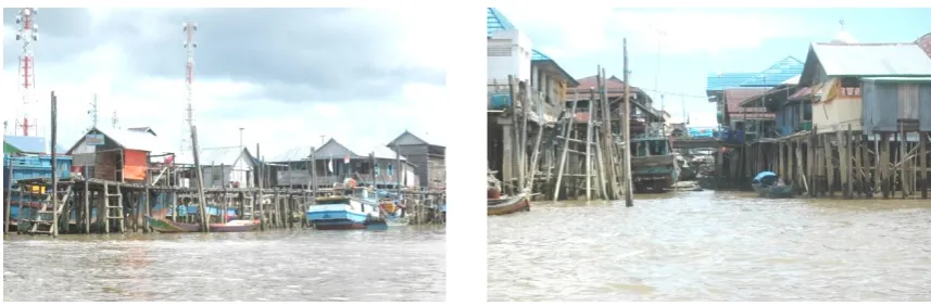
Tidal wave is a regular occurrence in these regions and its range up to 3 m. In adaptation to the environment, houses were built on stilts using a sturdy construction, and the floors are raised several meters above the sea level during the tide, in response to the tidal waves at the estuary. The houses and other supporting infrastructure are constructed during low tide when the available land is above the sea level on the available mudflats and sediment form. Based on its function the typologies of house on stilts can be divided into dwellings and public facilities, while its quality can be distinguished by vernacular buildings and the common buildings.
IV.1.2 Settlements pattern.
Sungsang is a tidal area in the river estuary where the fishing settlements were built on the edge of the river estuary for easy access to the waters and to fishing grounds, and unique factors such as close proximity to the sea have influence on settlement patterns. The topography a long estuary coastline is relatively flat resulted in the settlement's growth more regular follows a linear pattern formed by the edge of the estuary. Due to unavailability of water sources in the surrounding area, people meet water needs from rainwater or buying water from barges that carry water from the mainland. Sanitation systems is unknown and the people get used to dispose of wastewater and sewage directly into the river below
IV.2. Transformation Process of settlements
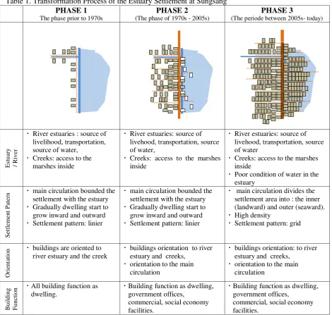
The evolution of physical and spatial form within the fishing settlement at Sungsang to be divided into three phases of transformation, namely:
1) The phase prior to the 1970s, before the establishment of Sungsang as a Local Service Center.
2) The phase of 1970s - 2005s, before the rapid dynamics of land use change in coastal areas which
open access from mainland toward the estuary
3) The period between 2005s until today.
Furthermore, the process of transformation in the fishing settlements in each phase will be addressed by such factors as estuary / river; settlement pattern; building function, building orientation, architecture typology; and construction materials.
IV.2.1. The phase prior to the 1970s.
The process of transformation in the early stage where Sungsang grew as a fishing village until its establishment as a Local Service Center. Furthermore, the process of transformation in this phase will be addressed to : estuary / river; settlement pattern; building function, building orientation, architecture typology; and construction materials.
used to dispose wastewater and sewage directly into the water below that makes the water quality at the area are affected by the wastewater and garbage. However, naturally the estuary has an ability in diluting the waste and the tide is regularly flushing the waste and garbage from that place.
Settlements Patterns of the settlements in this phase show that row of dwelling grew along the edge of the river estuary form a linear pattern, and other dwelling also grows linearly follow the creeks inward. Number of dwellings is still few and the distance between the dwellings is not too close. Gradually the dwellings grow, and linear pattern along the banks of the Musi river estuary forming layers. In front of the house which is located on the banks of the river estuary, the community built a jetty (pier). This dock is private because it was built by the homeowner. Dock on each building is connected and serves as a circulation path to link one house to another. The circulation paths are also built in front of the house which is located on the edge of the creek.
The building which located on the edge of the river estuary and on the edge of creeks mainly function as dwelling. All the buildings are oriented to the the river estuary and into the creek. House on a pole which grew on the edge of the estuary are built on a stage supported by a solid pole arrangement, in response to the waves at the the river estuary. Mostly the houses have a 3x5 m that covers living and sleeping spaces. Building typology dominated by vernacular building types which influenced by the culture of the Bugis
At this stage all house on stilts use of wood for structural poles or building. The wooden poles
supporting the buildings using ‘nibung’ wood that obtained from the surrounding environment. The
height of wooden stilts gauged for adequacy in height against flooding using local knowledge acquired over time. The wall structure material using wooden planks that arranged horizontally, some buildings used thatch as wall material. The floor made of timber covered which provides the space used for air circulation as well as ease of cleaning dirt from inside the house. The building uses a thatched roof of Nipah leaves supported by the roof structure. To overcome the problem of wind on the roof cover at the ridge is weighted that forms a cross. From the standpoint of the structure, the use of wood material is relatively lightweight, which supports the carrying capacity of the land which relatively weak.
4.2.2. The phase of 1970s - 2005s
The transition phase began around the 1970s when Sungsang was determinated as center of development. In efforts to improve regional infrastructure, the main circulation paths of settlement was built by the local government as jetties along the riverbanks as well as link one house to another, and visually represents the boundary between the settlements in the land and the estuary.
River estuaries and creeks in the area in this phase still have an important role in this phase, as a source of water, transportation lines linking settlements to sea, and a source of livelihood which is reflected through cultural activities fishermen's life. Construction of the main circulation paths affect estuarine waters as it restricts the use of creeks as a transportation hub to the inside so that the fisherman does not able to rely on boats. In this phase, support poles begin to impede the tide dilute and clean garbage under the settlement. Estuary waters become shallow because of sedimentation and water quality of estuaries decreased.
Settlements Pattern is strongly influence by the construction of main circulation path as well as a barrier between the settlement with the edge of river estuaries affect dwelling patterns. These pathways become public open space and the development of various social service function of the economy. On the outer side the circulation path becomes a place for the boat leans and place of several supporting facilities of fisheries activities. Growth continued to happened towards the sea.
Besides dwelling continues to grow, in this phase of the building which growing in the region include the functions of commercial and governmental functions. Dwelling buildings at the edge of the estuary and tributaries into the orientation of the building immediately at the edges, but the occupancy is at deeper layers in the building will be oriented to the circulation path in front of him. Commercial and government buildings oriented to the main circulation path that stretches in front of him. Typology of vernacular buildings began abandoned, new buildings for dwelling and commercial functions generally have a more contemporary type and simple.
constructed buildings as well as the replacement of old pole buildings which improved. Wooden rod
types nibung still widely used, other types of wood materials began to be used because it is easier to
obtain. The road was built with a wood construction. The walls are still dominated by the use of wooden planks arranged horizontally. The use of woven of leaves a building wall material is limited to old buildings as well as some simple building to support the activities of fishermen. Wooden plank are also used for the floors. From the aspect of the structure of the use of wood and roofing material is relatively lightweight, which supports the carrying capacity of the land which relatively weak.
Figure 1. The Structure of settlement pattern.
Source: field survey.
Figure 2. Group of dwellings predominantly occupy the seaward part of settlement.
Source: field survey
IV.2.3. The period between 2005s until today.
The final phase is the result of the growth of settlements which began in the previous phase. Physically, this phase is characterized by the rapid growth of settlements which extends and widens followed by the additions and improving the quality of roads. The development evolve makes the settlement pattern becomes thick and lengthy in shape.
The process of dwelling compaction is also resulting in environmental degradation. Thousand of poles blocking the flow of water and tidal water under building impacts on severe sedimentation, particularly at inland settlements. Trash and puddles of waste disposed by settlers directly into waters also caught by that building pillars and the tides does not able in diluting and regularly flushing the waste and garbage. The process of dwelling compaction is also resulting in environmental degradation.
the seashores and some of them occupy both sides of streams inward. Gradually the development evolves in inward direction where new layers of houses were built at the back of the former. Contras with the inner settlement pattern, the development of outward settlement evolves to the sea direction, and the process continues until it reaches its deepest foundation on the seabed at about 3 to 5 meters where building is still feasible with traditional techniques and timber materials.
Table 1. Transformation Process of the Estuary Settlement at Sungsang PHASE 1
The evolve development makes the settlements density in both side become high as a result of the additional building that occurs continuously without control. Right now the fishing settlement, in both sides inner and outer, has a density ranging from 180 to 195 units per hectare. Utilities system, such as sanitation and sewage system, electrical, and garbage are difficult to develop because of the limited space. Building density also eliminates green areas that have high environmental ecological benefit, the remaining green open land in the form of burial grounds. The expansion of dwelling to the mudflats landward is unavoidable, especially with the increasingly open access from the inland.
some vernacular building types. Therefore existence of vernacular buildings as the identity of the region started recessive. The house on stilts of vernacular dwelling has unique architectural details. Mostly the houses have 3x5 m that covers living and sleeping spaces. The building uses a thatched roof, thatch or wooden plank walls. The floor made of timber covered with a mat. All the factors form the unique traditions of the indigenous people.
In this phase the use of construction material is characterized by the development of the main circulation using reinforced concrete frame construction replaced the old circulation path using the material from wooden. The use of concrete materials for building poles, walls and floors of buildings is also growing rapidly. Public facilities, some of the which are multi-storey buildings, Generally started to replace the wood material with concrete. Most dwelling community also began to use concrete materials for building poles, however some of the which still using a simple wood
construction of nibung wood and various other wood types. The floors and walls mostly made of
timber and the use of zinc and asbestos roofing began to dominate the built-form in the area and even some buildings using a tiled roof.
IV.3. Influence to the Regional Development
Uncontrolled growth of the settlements greatly affect the vitality of Sungsang as a regional service center and the effort to implement some of the government's plan to develop Sungsang as the center of maritime activities and fish processing as well as the cultural tourism object.
IV.3.1. Carrying capacity
Settlement growth directly affects the environmental carrying capacity of this area, namely the scarcity of land and the poor quality of estuarine waters. Tidal land availability for development various activities are very limited. The expansion of dwelling to the mudflats landward is unavoidable, especially with the increasingly open access from inland. The poor water quality at the estuary and surrounding area that affected by the large number of wastewater and garbage can not be diluted by the natural ability of the estuary, and the tide has not able to clean up sludge and garbage trapped by the density of sub-structures.
Building density also holds the potential fire hazard due to the tight distance between buildings that mostly is using of wood that vulnerable to fire as a primary building material. Utilities system such as sanitation and sewage are difficult to develop because of the limited space. Green areas which have ecological benefit were eliminated and the remaining green open spaces at the area are formed by burial grounds. Growth in new houses as well as for routine repairs of existing buildings consumes a large amount of construction materials, especially old poles replacement. On the other hand the availability of traditional building materials especially for wooden poles is scarcely.
IV.3.2. Development of maritime activities and cultural tourism
Limited land became a major factor that affects the initiative to build such facilities for maritime development by promoting fishing productions. Sungsang development as a center of fisheries activities, both marketing and processing of fishery products require the provision of land for the development of the necessary facilities, such as cold storage, fish market, etc. This becomes important because Sungsang is not the location of fishing and processing.
Uncontrolled growth of settlements has eclipsed the region's identity due to the poor quality of water and environmental sanitation. A large amount of new building eventually cover some vernacular building types, therefore existence of vernacular buildings as the identity of the region started to recessive. This affects the efforts to explore the unique and aesthetic value of the fishermen settlements and the beauty of the natural surrounding as a tourist attraction. Also the provision of land needed to build several supporting facilities and activities based on the estuary environment.
V. CONCLUSION
Uncontrolled growth of house buildings in the area has exceeded the carrying capacity of the fishing settlement. Settlement patterns become very uncomfortable and need of government policies to prevent the further deleterious effect for sustainability of the settlements, enforcing zoning rules, controlling the growth of settlements, and to force the people to live in the surrounding area.
Revitalization of settlements is needed in response the quality and reliability of the settlements primarily associated with the utilities and people's habits. The revitalization process of area spanning the improvement of physical and economic aspects of buildings and areas, therefore revitalization is also needed to support the development of other Sungsang's potential in relation to maritime activities, fishing, and tourism.
The developments of alternative location for new dwelling and socio economics facilities that urgently needed are crucial because it is concerned with social and environmental aspect. Settlement patterns should be developed using technology appropriate to settlers and the locations should be strategic and next to the major transport system. The building has to base on the concept of the traditional house-form and form the pattern of former fishing settlements.
REFERENCES
[1] Ann Breen, Dick Rigby, Waterfront - Cities Reclaim Their Edge. New York: The McGraw-Hill
Companies, 1994.
[2] Amos Rapoport, Human Aspects of Urban Forms, Toward a Man – Environment Approach to Urban
Form and Design. New York: Pergamin Press, 1977.
[3] C. A. Doxiadis, “Ekistics, the Science of Human Settlements,” Science, vol. 170, no. 3956, pp. 393–464
: 22 fig., 1970.
[4] Iwan Suprijanto, Karakteristik Spesifik, Permasalahan dan Potensi Pengembangan Kawasan Kota Tepi
Laut (Coastal City) di Indonesia. Jakarta: 2007.
[5] Ira Mentayani, Transformasi Adaptif Permukiman Tepi Sungai Di Kota Banjarmasin. Disertasi,
Yogyakarta: Universitas Gadjah Mada, 2015..
[6] Mulyadi, Ekonomi Kelautan. Jakarta: PT Raja Grafindo Perkasa, 2007.
[7] N. J. Habraken, Transformation Of The Site. Massachusetts: Cambridge, 1982.