SPATIO-TEMPORAL CHANGE MODELING OF LULC: A SEMANTIC KRIGING
APPROACH
Shrutilipi Bhattacharjeea, Soumya K. Ghoshb∗
ab
School of Information Technology, Indian Institute of Technology Kharagpur, West Bengal-721302, India Email:[email protected],[email protected]
KEY WORDS: Remote sensing, Prediction, Kriging, LULC, Data semantic, Ontology
ABSTRACT:
Spatio-temporal land-use/ land-cover (LULC) change modeling is important to forecast the futureLULC distribution, which may facilitate natural resource management, urban planning, etc. The spatio-temporal change inLULCtrend often exhibits non-linear behavior, due to various dynamic factors, such as, human intervention (e.g., urbanization), environmental factors, etc. Hence, proper forecasting ofLULCdistribution should involve the study and trend modeling of historical data. Existing literatures have reported that the meteorological attributes (e.g.,NDVI,LST,MSI), are semantically related to the terrain. Being influenced by the terrestrial dynamics, the temporal changes of these attributes depend on theLULCproperties. Hence, incorporating meteorological knowledge into the temporal prediction process may help in developing an accurate forecasting model. This work attempts to study the change in inter-annualLULCpattern and the distribution of different meteorological attributes of a region in Kolkata (a metropolitan city in India) during the years 2000-2010 and forecast the future spread ofLULCusingsemantic kriging(SemK) approach. A new variant of time-seriesSemKis proposed, namelyRev-SemKtsto capture the multivariate semantic associations between different attributes. From
empirical analysis, it may be observed that the augmentation of semantic knowledge in spatio-temporal modeling of meteorological attributes facilitate more precise forecasting ofLULCpattern.
1. INTRODUCTION
One of the major challenges associated in monitoring the envi-ronmental changes is to predict the meteorological pattern with highest degree of accuracy. Further, forecasting the land-use/ land-cover (LULC) change will help in assessing the impact of ur-banization, city planning, and other socio-economic activities. It has direct impact on several environmental threats, such as: urban heat island, drought, flood, etc. Several studies have reported that the meteorological attributes (for example,land surface tempera-ture(LST),normalized difference vegetation index(VI),moisture stress index (MSI), etc.), that are near to the earth surface are influenced by the behavior ofLULC, and positively correlated with its distribution pattern [(Hengl et al., 2012) (Bhattacharjee et al., 2014)]. Hence, their spatio-temporal analysis may incor-porate the knowledge ofLULCby semantic analysis of the ter-rain to achieve better accuracy. Therefore, the meteorological attributes and theLULCcan be regarded as the inter-dependent factors of the terrain, which together influence the environmental changes. This work focuses on the spatio-temporal forecasting of land-use/ land-cover (LULC) distribution pattern of a spatial re-gion, by learning the past behaviors of meteorological data. It has been hypothesized by the scientists that the twenty first century will be an era of predicting the weather/ meteorological patterns with some well-defined mathematical equations (Shukla, 1998). However, the model which can deal with all the spatial uncertain-ties with high accuracy is lacking. Though prediction/ forecast-ing of meteorological attributes have been studied extensively in the field ofremote sensingandgeographic information system, however accuracy is still a major research challenge. In most of the cases of meteorological forecasting, the auxiliary information in the terrain are overlooked, which have a huge impact on the primary attribute to be predicted, and often contribute to achieve better accuracy. Hence, the shift of research paradigm from uni-variate to multiuni-variate scenario is indispensable for the accurate mapping of the environmental changes.
∗Corresponding author
In order to carry out a data driven approach for analyzing the past behavioral pattern of the meteorological attributes, the krig-ing(Humme et al., 2006) based interpolation methods have been reported as the most popular, widely used, and best suitable tech-niques in literature, for handling spatial variability of the terrain. One such way to deal with this variability is to make use of other secondary information while predicting the actual or the primary variable/ attribute. In that case, the secondary variables have to be correlated with primary and must influence it significantly. In the literatures of geo-statisticalkrigingestimators, the commonly known approaches which can accommodate these multivariate information into the interpolation process are co-kriging, krig-ing with external drift,regression kriging, etc. However, most of these methods (both univariate and multivariate) have ignored to model the semanticLULCknowledge of the terrain for predicting meteorological attributes. In previously proposed interpolation methods, namelysemantic kriging(SemK) (Bhattacharjee et al., 2014) andtimes-series semantic kriging(SemKts) (Bhattacharjee
and Ghosh, 2015) , theLULCbased knowledge is incorporated in the prediction equation for better (accurate) estimation of dif-ferent meteorological attributes. The traditional two dimensional spatial auto-correlation model,semivariogramhas been extended further in spatio-semanticsemivariogrammodel, for analyzing, quantifying the impact of semanticLULCknowledge over other meteorological attributes. The proposed work also focuses on the spatio-temporal forecasting, however, the distribution ofLULC has been considered as the primary variable to be predicted. The proposed work is a new interpolation based approach, namely Rev-SemKts, which can be regarded as the reversetimes-series
broad objectives of the work can be stated as follows:
• extending thetimes-series semantic krigingin multivariate scenario for the augmentation of the auxiliary spatial infor-mation of the terrain
• modeling a reverseSemKapproach,Rev-SemKts, for
quan-tifying the temporal change of semantic knowledge (or, the change inLULCpattern) with respect to other meteorologi-cal attributes
• modeling the spatio-temporalsemivariograms andcross- semi-variograms for analyzing the correlation among different factors
• modeling the estimation equation forRev-SemKtsto
fore-cast theLULCdistribution pattern in future time instances
• experimentation with real meteorological data, to demon-strate the efficacy of the proposed method
The rest of the paper is organized as follows. Section2.presents the state of the art related to theLULCchange modeling, forecast-ing ofLULCpattern, utilizing this knowledge for the prediction of meteorological attributes, etc. The preliminary works on se-mantic kriging, and its time-series extension are presented in the Section 3. The framework on forecasting of the futureLULC pattern using the proposed Rev-SemKts approach is presented
in Section4. The experimental results, yield by the proposed approach are presented in Section5. Finally, the conclusion is drawn in the Section6.
2. BACKGROUND
Many literatures have reported the impact ofLULCchange mod-eling for the detection of global environmental dynamism, oper-ational planning of different biospheric, atmospheric aspects, ur-ban and city planning, disaster management, etc. Elliset al.( El-lis and Porter-Bolland, 2008) have compared the change ofLULC in two neighbouring study areas in the Central Yucatan Peninsula Region of Mexico. They have discussed about the dominant path-ways inLULCand the factors influencing deforestation and forest conservation processes occurring in the study region. Schilling et al. (Schilling et al., 2010) have studied how the change in LULCinfluences the rapid expansion of soybean cultivation in the Mississippi River basin, and found it to be highly influen-tial for the regional water and climate patterns. Mu˜noz-Villers et al. (Mu˜noz-Villers and L´opez-Blanco, 2008) have monitored theLULCchanges between 1990 and 2003 in a tropical moun-tainous watershed using Landsat TM imagery. They have used a RS-GIS approach and achieved above 75% classification ac-curacy. Hoeket al. (Hoek et al., 2008) have used the land-use regression methods for modeling annual mean concentrations of different meteorological attributes such as:N O2,N Ox,P M2.5,
etc. in European and North-American cities.
A very few works have been reported on modeling theLULC knowledge for the interpolation based prediction of meteorolog-ical attributes, and vice-versa. Though some of the articles state the importance of this knowledge for different meteorological analysis, however they fail to quantify and incorporate this prop-erty of the terrain into the prediction process. Henglet al.(Hengl et al., 2012) have reported the land-cover pattern to be one of the influencing factor for predicting theland surface tempera-turetrend. Several other literatures [(Lambin and Geist, 2006) (Mahmood et al., 2010) (Sertel et al., 2011)] have also mentioned
about the significance of this knowledge for the weather/ climatic patterns and their dynamics. Janssenet al.(Janssen et al., 2008) have proposed a detrendedkrigingmodel, namelyRIO, for air pollution measurement. They have used CORINELULCdata for developing the land-use indicator. Petris¸oret al. (Petris¸or et al., 2010) have examined whether a study region is affected at macro-scale through the changes of land-cover or land-use. They have usedordinary kriging method for capturing the en-vironmental changes and their effect on land-use. As far as our knowledge is concerned, no such article have been reported re-garding the reverse analysis of meteorological attributes, such as: LST,NDVI, etc., using multivariate spatial interpolation for forecasting the futureLULCpattern. The previous works on se-mantic kriging [(Bhattacharjee et al., 2014) (Bhattacharjee and Ghosh, 2014)] are one of the initial attempts to incorporate this knowledge into the interpolation process for meteorological at-tribute prediction. It has been further extended to temporal do-main, resulting univariatetimes-series semantic kriging(SemKts)
(Bhattacharjee and Ghosh, 2015), for forecasting. The proposed method can be considered as the reverseSemKtsprocess in
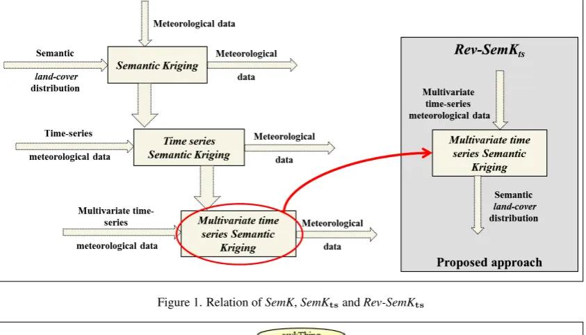
mul-tivariate scenario. The overall idea of the proposed approach and its relationship with the existing works onsemantic krigingare depicted in Fig1. The subsequent sections present the overview of the basicSemKtechnique, mainly on the quantification of se-manticLULCknowledge, and its temporal extension.
3. SEMANTIC KRIGING (SEMK) AND ITS TIME-SERIES EXTENSION
Thesemantic kriging(SemK), initially proposed in ( Bhattachar-jee et al., 2014), attempts to quantify the semanticLULC knowl-edge of the terrain for the prediction of meteorological attributes through spatial interpolation. It extends the traditional semivari-ogrammodel into a three dimensional spatio-semantic semivari-ogram, by incorporating the distribution pattern and influence of the surrounding spatial feature for thevariancemodeling. One of the most popularkrigingbased methodordinary kriging(OK) (Stein, 1999) has been extended further with the quantified se-mantic knowledge for modeling the relatedness between the sam-ple points. For quantifying this new knowledge of the terrain, the association between the representative spatial features of the sample points is mapped such that it adhere to the Tobler’s law of spatial proximity (Tobler, 1970). That is, the semantically sim-ilar and the correlated features should be assigned more weigh-tage than a dissimilar feature, and vice-versa. This association between different land-cover classes are measured by organiz-ing them into an ontology hierarchy [(Bhattacharjee et al., 2014) (Bhattacharjee et al., 2012)]. It is built with the exhaustive feature set (LULCclasses) of the spatial region of interest (RoI). Figure 2presents an example ontology hierarchy for the spatial study re-gion Kolkata, India. It is constructed with reference to theLULC classification classes, reported by NRDMS, India in (Mendiratta et al., 2008). The“is-a”(hyponym) semantic relation is consid-ered here to map the type of association between classes, how-ever, any semantic relation could have been used, depending on the application requirement.
For the quantification of this semantic knowledge, each of the sampled locations are then mapped to the most appropriate rep-resentativeleaf feature in the hierarchy. Two metrics have been proposed for analyzing the association between a pair of leaf fea-tures in the hierarchy, namely:semantic similarityand thespatial importance. For the actual interpolation process, these two met-rics are used for mapping the traditionalcovariancemeasure into higher semantic dimension.
Figure 1. Relation ofSemK,SemKtsandRev-SemKts
Figure 2. Spatial feature ontology for meteorological attribute prediction (Bhattacharjee and Ghosh, 2015)
3.1 Semantic Similarity
This metric is analyzed between any pair of sample points or their representative leafLULCclasses in the ontology hierarchy. Mod-ifiedcontext resemblance method (Manning et al., 2008) have been used here for modeling the metric. Thesemantic similarity between theith
andjth
sample points (or their representative fea-turesfiandfjreferring the ontology) is denoted asSSij, given
as follows:
SSij= mi |fi| +
mj |fj|
2 (1)
where,|fi|and|fj|are the total number ofLULCclasses in the ithandjthfeature paths;m
i andmj are the number ofLULC
classes matching in both the paths in the ontology, respectively.
3.2 Spatial Importance
This metric is more pragmatic one as it considers the real-time sample points from the terrain. Hence this metric may change with respect to the study region, time, and the attribute to be pre-dicted. Thespatial importancebetween each pair of leafLULC classes is measured by the correlation analysis between the sam-pled locations, represented by these features with respect to the prediction attribute. First, the entireRoIis divided intoknumber of non-overlapping zones (Rk) such that∪ki=1Rk=RoIandk
pairs of sample points (representing the pair of features) are cho-sen from each of the zones. Next, the pairwise correlation score is measured with thesekpairs of sample points, which is termed asspatial importancebetween the pair of features. Thespatial importancebetweenithandjthsample points, or their represen-tative featuresfiandfjin the ontology, is denoted asSIijand
is given as follows:
SIij=CorrM P(fi, fj)
=
k
∑
m=1
(Z(fim)−Z(fi))(Z(fjm)−Z(fj))
√
k
∑
m=1
(Z(fim)−Z(fi))2 k
∑
m=1
(Z(fjm)−Z(fj))2
(2)
where,Z(fpq)represents the random field value of theq
th
sam-ple point, representing the featurefp;Z(fp)represents the
aver-age of the random field values of the featurefp, overksample
points; MP is the meteorological attribute to be predicted.
3.3 Times-series Semantic Kriging (SemKts)
extended in temporal dimension. This modeling is presented in (Bhattacharjee and Ghosh, 2015). Between the two semantic metrics, the evaluation of thesemantic similaritysolely depends on the structure of the ontology hierarchy. As this hierarchy is built with the exhaustive spatial feature set, it remains static with respect to time, hence the time-seriescovariance(more generally the relatedness) between anyLULCclasses with respect to this metric would be same with the spatialcovariancebetween them. Therefore, its temporal evaluation (time-series semantic similar-ity) will be same with the spatialsemantic similarity( Bhattachar-jee et al., 2014).
However, as thespatial importancedeals with real-time data for its evaluation process, the significance of temporal lag between the sample points is highly evident for this metric. Given any two sampled locations (xi, t−i) and (xj, t−j), represented byfiand fjland-cover classes respectively, the whole study region is again
divided intoknumber of random zones. Thekpairs of sample points are chosen and measured for bothfiandfj, but from
dif-ferent time instances,t−iandt−j, respectively. The correlation
analysis is carried out between thesekpairs. The temporal exten-sion of thespatial importancemetric is termed astime-series im-portance(SIts). Hence, thetime-series importancebetween any
ithandjthsample points (or their representative
LULCclasses
pq)represents the attribute value of theq
th
sam-ple point, representing the featurefpat time instancet−u, and Zt−u(fp)is the average attribute value of the featurefpoverk sample points at the time instancet−u.
4. REV-SEMKTS: REVERSE TIMES-SERIES
SEMANTIC KRIGING
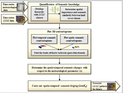
This section presents the detailed description of the proposed reverse times-series semantic kriging(Rev-SemKts) framework.
The overall process flow of the framework is depicted in Figure 3. In this framework, the meteorological data and theLULC dis-tribution of the terrain are considered as the input. After quantifi-cation of the semantic knowledge (Bhattacharjee et al., 2014), the temporal and spatial inter-relationships among the meteorologi-cal attributes and the differentLULCclasses are evaluated. Con-sidering the 3D spatio-semantic and temporal-semantic semivari-ogrammodels, the futureLULCdistribution pattern is forecasted using the proposed approachRev-SemKts. It can be considered
as the multivariate extension ofSemKtstechnique (Bhattacharjee
and Ghosh, 2015).
This work assumes that if thereNsampled locations in past time instances, anyith
sample point can be characterized as (xi,{Z1i,
Z2i, ..., Zpi},LCi,t−i). That is the sampled locationxi, mea-sured at the past time instancet−i. Thepnumber of
meteorolog-ical attributes are measured asZ1i, Z2i, ..., Zpi, at the sample pointxi, and its corresponding land-coverLCi (or,fi) is also
known. Here, for our analysis, we have considered two meteo-rological attributes,LSTandNDVI, hencep= 2. For the fore-casting ofLC0at the interpolation pointx0, only past land-cover information could have been used. However, incorporation of
other meteorological knowledge may yield more accurate estima-tion. The proposed framework extends thetimes-series semantic kriging(SemKts) (Bhattacharjee and Ghosh, 2015) in
multivari-ate domain, where multiple secondary attributes are considered for predicting the primaryLULCinformation of the terrain. The general assumption in multivariate scenario is that the secondary attributes must be correlated with the primary and are estimated jointly utilizing a BLUE (best linear unbiased estimator) ( Hen-derson, 1975). In univariate scenario, the estimation equation of semantic krigingcan be given as:
ˆ
whereZˆ(x0)is the estimated primary attribute value at the pre-diction point(x0),Nis the total number of interpolating points,
xiis the attribute values at theithinterpolating point, andwiis
the weight assigned to each of the interpolating point. In multi-variatesemantic kriging, as two time-series [LST(Z1) andNDVI (Z2)] have been considered as the secondary attributes for the es-timation, the two multivariate estimation equations are given as follows:
Being an extension of ordinary kriging, both the above
equa-tions are constrained by following condiequa-tions:
N
w2i= 1(as unbiased estimator).
Thewpi is the weight assigned to the interpolating points, cal-culated from thesemivariogrammodel. In spatial context, a plot ofsemivarianceversusdistancebetween known sample points is termed assemivariogram. InRev-SemKts framework, the
rela-tionship between meteorological attributes and theLULCclasses is determined using thesesemivariogrammodels. Therefore, the concept of semivariogramis further extended in semantic and temporal dimension, resulting spatio-semantic and temporal-semantic semivariogrammodels. In our application, the prediction attribute
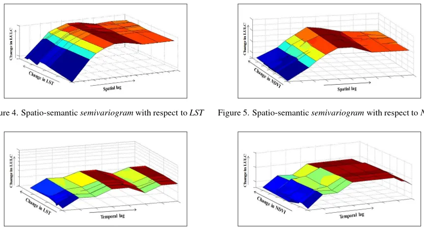
Zbeing the land-use/ land-cover of the terrain, the quantification of this knowledge is carried out using the methods as specified in Section3. Once this knowledge is quantified, the correspond-ing changes in primary attribute with respect to the secondary in space and time domain is evaluated usingsemivariogrammodels. Hence, for the two individual auxiliary time-series, the spatio-semantic and temporal-spatio-semanticsemivariogrammodels are de-picted in Figures4,5,6,7, respectively. Thesesemivariograms are created by taking the distance/temporal lag (X axis) and the change of meteorological attribute (Y axis) as the independent variables, and the change ofLULCas the dependent variable (Z axis).
However, the knowledge of both the meteorological attributes can also be used in order to evaluate how the change ofLULCtakes place with respect to the change in both the attributes together. In that case, thesemivariograms between the two or more semi-variograms (cross-semivariogram) (Vauclin et al., 1983) should be modeled. Figures8and9depict the change inLULCwith respect to bothLSTandNDVItogether, in spatial and temporal domain, respectively.
Once thesesemivariograms are modeled, theSemKtsapproach is
Figure 3.Rev-SemKtsFramework
carried out. The traditional spatio-temporalsemivariance matri-ces,Ct, also referred asWt1(with respect to the sampled
loca-tions), andDt
(with respect to the sampled and unsampled loca-tions) are modified with the semanticsemivariogrammeasures, resultingCtsandDtsmatrices forLULC, respectively. Each el-ement of the two matrices, i.e.,CtijinC
t
andDt0iinD t
are modified as:Cts
ij = ∆fijandD0tsi= ∆f0i, where∆fpqdenotes
the amount of change inLULCas (SItspq∗SSpq). Hence, as
already derived in (Bhattacharjee et al., 2014), the weight vec-tor produced by proposedRev-SemKts framework is given as: WRev-SemKts =C
ts−1
[Dts
−λts1], where,λtsis the
time-seriesLagrange multiplierofRev-SemKts.
5. EXPERIMENTAL RESULTS
For the performance analysis of the proposed approach, an em-pirical experimentation has been carried out with real meteoro-logical data, for the study region Kolkata (a metropolitan city in India, with central coordinate: 22.567◦N 88.367◦E). The satel-lite remote sensing imagery (Landsat ETM+,) offered by United States Geological Survey (USGS)1, have been used for this study.
These imagery are processed further with the standard satellite image processing tools to obtain theland surface temperature (LST),normalized difference vegetation index(NDVI) data of the terrain. A supervised classification on the satellite imagery yields theLULCdistribution map of the study region. The signature of six different land-cover classes have been considered for classify-ing the terrain, such as:forest,agriculture,wastelands,built-up, waterbodies, andwetlands. For the time-series analysis, eleven years data have been considered, for the duration 2000-2010. In order to best fit thesemivariogrammodels, past ten years data have been used (duration 2000-2009) for forecasting theLULC distribution map in the year 2010.
1
http://www.usgs.gov/
The forecasting have been carried out for some unsampled loca-tions of the terrain by the proposed approachRev-SemKts. Two
zones in the region Kolkata are further subdivided into five sub-zones, where the predictions have been carried out separately. Three types of external drift have been considered, such as:LST, NDVI, and bothLSTandNDVI. One standard error metric is con-sidered to quantify the accuracy in prediction, namelyroot mean square error(RMSE). It may be observed from the case study that the proposed approach with the external drift of more than one correlated meteorological attributes forecast the futureLULC distribution pattern better than other two cases (considering the drift with single attribute).
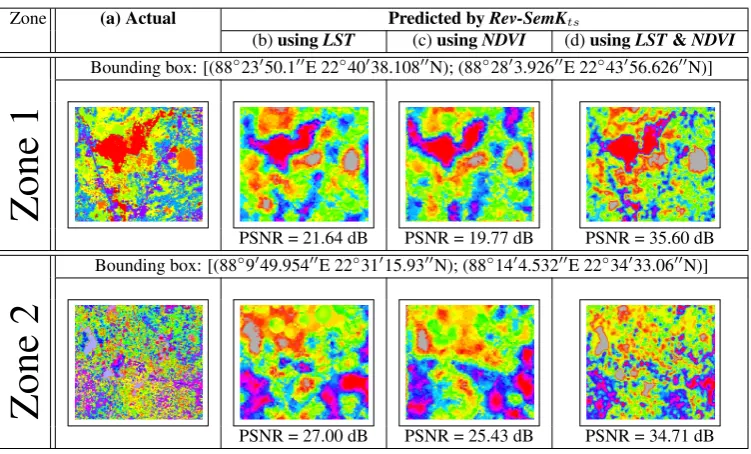
As mentioned, two spatial zones have been considered from the whole study area, as shown in Table1(the bounding box is spec-ified as: [lower left corner, upper right corner]). The forecasted LULCimagery of both the zones are also depicted in Table1. The actualLULCimage is shown, along with the predicted im-agery byRev-SemKts, using the drift ofLST,NDVI, and bothLST
andNDVI, respectively. It has been found that theRev-SemKts,
with more number of meteorological attribute information, gen-erates better forecasted image and results in higherPSNR(peak signal-to-noise ratio), compared to single attribute drift (≈10-15 dB higher).
6. CONCLUSION
Figure 4. Spatio-semanticsemivariogramwith respect toLST Figure 5. Spatio-semanticsemivariogramwith respect toNDVI
Figure 6. Temporal-semanticsemivariogramwith respect toLST Figure 7. Temporal-semanticsemivariogramwith respect toNDVI
(a) RMSE for zone 1 (b) RMSE for zone 2
Figure 10. Prediction error reported using RMSE for five exclusive subzones in two zones
proposed framework,Rev-SemKts, learns the past behavior of the
selected meteorological attributes, for example,land surface tem-perature,normalized difference vegetation index, etc. Based on the inter-relationships of the pastLULCpattern with these corre-lated attributes, its future trend is predicted. The proposed Rev-SemKtsis based on the notion ofsemantic kriging, and can be
considered as the multivariate extension of its one of the variants, SemKts. The case study with real meteorological data shows the
efficacy of the proposed method and proves that the incorporation of more correlated attribute information of the terrain enhance the prediction accuracy ofLULCpattern. This framework can be ex-tended further for statistically choosing the appropriate meteoro-logical attributes which are positively correlated withLULC, and for forecasting other semantic knowledge of the terrain as well.
ACKNOWLEDGMENT
This work is partially supported by the Department of Science and Technology, New Delhi, India, under INSPIRE program.
REFERENCES
Bhattacharjee, S. and Ghosh, S. K., 2014. Performance evalua-tion of semantic kriging: A Euclidean vector analysis approach. IEEE Geoscience and Remote Sensing Letters 12(6), pp. 1185– 1189.
Bhattacharjee, S. and Ghosh, S. K., 2015. Time-series augmen-tation of semantic kriging for the prediction of meteorological parameters. In: 28th IEEE International Geoscience and Remote Sensing Symposium (IGARSS 2015), IEEE.
Bhattacharjee, S., Dwivedi, A., Prasad, R. R. and Ghosh, S. K., 2012. Ontology based spatial clustering framework for implicit knowledge discovery. In: Annual IEEE India Conference (INDI-CON), pp. 561–566.
Bhattacharjee, S., Mitra, P. and Ghosh, S. K., 2014. Spatial in-terpolation to predict missing attributes in GIS using semantic kriging. IEEE Transactions on Geoscience and Remote Sensing 52(8), pp. 4771–4780.
Ellis, E. A. and Porter-Bolland, L., 2008. Is community-based forest management more effective than protected areas?: A com-parison of land use/land cover change in two neighboring study areas of the central Yucatan Peninsula, Mexico. Forest Ecology and Management 256(11), pp. 1971–1983.
Henderson, C. R., 1975. Best linear unbiased estimation and pre-diction under a selection model. Biometrics pp. 423–447.
Hengl, T., Heuvelink, G. B., Tadi´c, M. P. and Pebesma, E. J., 2012. Spatio-temporal prediction of daily temperatures using time-series of MODIS LST images. Theoretical and applied cli-matology 107(1-2), pp. 265–277.
Zone (a) Actual Predicted byRev-SemKts
(b)usingLST (c)usingNDVI (d)usingLST&NDVI
Bounding box: [(88◦23′50.1′′E 22◦40′38.108′′N); (88◦28′3.926′′E 22◦43′56.626′′N)]
Zone
1
PSNR = 21.64 dB PSNR = 19.77 dB PSNR = 35.60 dB Bounding box: [(88◦9′49.954′′E 22◦31′15.93′′N); (88◦14′4.532′′E 22◦34′33.06′′N)]
Zone
2
PSNR = 27.00 dB PSNR = 25.43 dB PSNR = 34.71 dB
Table 1. Comparison study with (a) actualLULCdistribution imagery, and the predicted imagery (b) usingRev-SemKtswithLST, (c)
Rev-SemKtswithNDVI, (d)Rev-SemKtswithLST&NDVI
Figure 8. Spatio-semanticcross-semivariogram with respect to LSTandNDVI
Figure 9. Temporal-semanticcross-semivariogramwith respect to LSTandNDVI
Hoek, G., Beelen, R., de Hoogh, K., Vienneau, D., Gulliver, J., Fischer, P. and Briggs, D., 2008. A review of land-use regres-sion models to assess spatial variation of outdoor air pollution. Atmospheric Environment 42(33), pp. 7561–7578.
Humme, A., Lindenbergh, R. and Sueur, C., 2006. Revealing celtic fields from LIDAR data using kriging based filtering. In: Proceedings of the ISPRS Commission V Symposium.
Janssen, S., Dumont, G., Fierens, F. and Mensink, C., 2008. Spa-tial interpolation of air pollution measurements using corine land cover data. Atmospheric Environment 42(20), pp. 4884–4903.
Lambin, E. F. and Geist, H. J., 2006. Land-use and land-cover change. Local Processes and Global Impacts p. 222.
Mahmood, R., Quintanar, A. I., Conner, G., Leeper, R., Dobler, S., Pielke Sr, R. A., Beltran-Przekurat, A., Hubbard, K. G., Niyogi, D., Bonan, G. et al., 2010. Impacts of land use/land cover change on climate and future research priorities. Bulletin of the American Meteorological Society 91(1), pp. 37–46.
Manning, C. D., Raghavan, P. and Sch¨utze, H., 2008. Introduc-tion to InformaIntroduc-tion Retrieval. Vol. 1, Cambridge University Press.
Mendiratta, N., Kumar, R. S. and Rao, K. S., 2008. Standards for bio-geo database. Technical Report 1, Natural Resources Data Management System (NRDMS) Division, New Delhi, India.
Mu˜noz-Villers, L. E. and L´opez-Blanco, J., 2008. Land use/cover changes using landsat TM/ETM images in a tropical and biodi-verse mountainous area of centraleastern mexico. International Journal of Remote Sensing 29(1), pp. 71–93.
Petris¸or, A.-I., Ianos¸, I. and T˘alˆang˘a, C., 2010. Land cover and use changes focused on the urbanization processes in roma-nia. Environmental Engineering and Management Journal 9(6), pp. 765–771.
Schilling, K. E., Chan, K.-S., Liu, H. and Zhang, Y.-K., 2010. Quantifying the effect of land use land cover change on increas-ing discharge in the upper mississippi river. Journal of Hydrology 387(3-4), pp. 343–345.
Sertel, E., Ormeci, C. and Robock, A., 2011. Modelling land cover change impact on the summer climate of the marmara region, turkey. International Journal of Global Warming 3(1), pp. 194–202.
Shukla, J., 1998. Predictability in the midst of chaos: A scientific basis for climate forecasting. science 282(5389), pp. 728–731.
Stein, M. L., 1999. Interpolation of Spatial Data: Some Theory for Kriging. Springer Verlag.
Vauclin, M., Vieira, S., Vachaud, G. and Nielsen, D., 1983. The use of cokriging with limited field soil observations. Soil Science Society of America Journal 47(2), pp. 175–184.