INTEGRATION OF SATELLITE RAINFALL DATA AND CURVE NUMBER METHOD
FOR RUNOFF ESTIMATION UNDER SEMI-ARID WADI SYSTEM
Eltayeb O. Adam ¹, *, Mohamed A. M. Abd Elbasit ², Tesfamichael Solomon ¹, Fethi Ahmed ³
¹ Department of Geography, Environmental Management & Energy Studies, Faculty of Science, University of Johannesburg, Auckland Park Kingsway Campus, Johannesburg, SA – [email protected], [email protected] ² Agricultural Research Council-Institute for Soil, Climate and Water, Pretoria, South Africa - [email protected]
³ School of Geography, Archaeology and Environmental Studies, University of Witswatersrand, Johannesburg; SA - [email protected]
Commission VI, WG VI/4
KEY WORDS: Hydrology, Ungauged, Water harvest, Spatial variation, Catchment, TRMM
ABSTRACT:
The arid and semi-arid catchments in dry lands in general require a special effective management as the scarcity of resources and information which is needed to leverage studies and investigations is the common characteristic. Hydrology is one of the most important elements in the management of resources. Deep understanding of hydrological responses is the key towards better planning and land management. Surface runoff quantification of such ungauged semi-arid catchments considered among the important challenges. A 7586 Km² catchment under investigation is located in semi-arid region in central Sudan where mean annual rainfall is around 250 mm and represent the ultimate source for water supply. The objective is to parameterize hydrological characteristics of the catchment and estimate surface runoff using suitable methods and hydrological models that suit the nature of such ungauged catchments with scarce geospatial information. In order to produce spatial runoff estimations, satellite rainfall was used. Remote sensing and GIS were incorporated in the investigations and the generation of landcover and soil information. Five days rainfall event (50.2 mm) was used for the SCS CN model which is considered the suitable for this catchment, as SCS curve number (CN) method is widely used for estimating infiltration characteristics depending on the landcover and soil property. Runoff depths of 3.6, 15.7 and 29.7 mm were estimated for the three different Antecedent Moisture Conditions (AMC-I, AMC-II and AMC-III). The estimated runoff depths of AMCII and AMCIII indicate the possibility of having small artificial surface reservoirs that could provide water for domestic and small household agricultural use.
1. INTRODUCTION
The arid and semi-arid catchments in dry lands in general require a special effective management as the scarcity of resources and information which is needed to leverage studies and investigations is the common characteristic. Hydrology is one of the most important elements in the management of resources. Large heterogeneity of the landscape, short duration and high intensity patterns of rainfall of the semi-arid areas make the hydrological regime more extreme and highly variable. Deep understanding of hydrological responses is the key towards better planning of water resources and land management. There is little expert knowledge available that supports water resource management in arid and semi-arid areas (Wheater et al., 2007) and limited understanding of the links between climate, land use and hydrology of dryland regions (Bromley et al., 1999; Mango et al., 2011). The hydrological data for Wadi El hawad catchment the wadi under investigation is sparse. The objective of the study is to parameterize hydrological characteristics of the catchment and quantify surface runoff using suitable methods and hydrological models that suit the nature of such ungauged catchments. Besides, introducing alternative data sources in attempt to solve data scarcity problem within geographical information systems (GIS) environment.
The term “Wadi Hydrology” is a new emerging branch in Hydrology (Sen, 2008). Although, there is not many studies conducted on Wadi hydrology (Shahin, 2007) the little research
work that has been conducted so far is considered remarkable. The hydrology of arid and semi-arid regions is unique and this raises an important scientific and technical challenges when it comes to undertaking research. Therefore, an improved knowledge base is essential to meet current and future needs of water resources management in semi-arid areas (Wheater and Al-Weshah, 2002) especially an integrated wadi water resources management is seen as the answer to these challenges (Salih and Ghanem, 2002).
rainfall sources gauged and satellite borne rainfall data were used for the model. Because the spatial variation of input data is important (Diek et al., 2014) in order to produce spatial runoff estimations, satellite rainfall was used to attain the spatial variation. The Tropical Rainfall Measuring Mission (TRMM) precipitation sensor was selected. Although the TRMM data has shown high variation in the correlation coefficient under different rainfall depths and locations in semi-arid region in Sudan (Mohamed et al, 2014), still it is an alternative to estimate runoff in conditions where rainfall data is scarce (Chatterjee et al, 2016). Recent hydrological models computation rely heavily on Digital Elevation Models (DEM) (Moore and Grayson, 1991). DEM used in hydrology to parametrize catchment’s topographic and hydrologic features such as flood plains, mountains, valleys and flat lands, catchment and Sub-catchment boundaries and drainage networks. All required parameter were fed into the SCS model in GIS environment and the catchment surface runoff was computed.
This research is designed to expand on the limited existing current body of knowledge and advance our understanding of the semi-arid hydrology in semi-arid region in central Sudan by adopting an integrated approach and using relevant models and introducing new alternatives for enhancing surface runoff estimations. The objective was to parameterize hydrological characteristics of the catchment and estimate surface runoff using suitable methods and hydrological models that suit the nature of such ungauged and scarce geospatial information. In semi‐arid regions, small artificial surface reservoirs are important to meet the domestic and agricultural water requirements. Sub-catchment water harvesting potential was investigated and the yielded runoff estimation indicated that there is possibility of having small water harvesting projects.
2. MATERIALS AND METHODS
2.1 Study Area
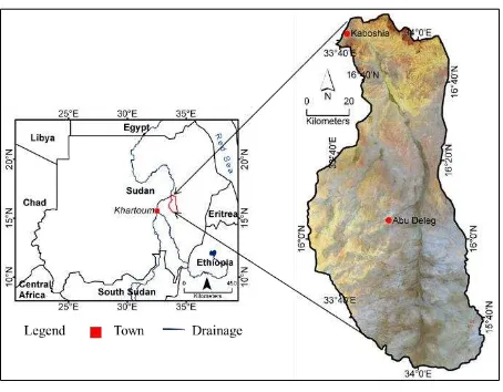
The study area is known as Wadi El Hawad catchment that covers 7586 km² in the semi-arid region of central Sudan, and approximately 160 km north of Khartoum (Figure. 1). The climate is typically semi-arid with short dry winter season and long dry hot summer season within which rainfall occurs. Annual mean temperature is 46 ºC in summer to 10 ºC in winter and the average is 27 ºC. The annual rainfall ranges from 75 to 250 mm and it is commonly characterized by extreme high spatial and temporal variation. The hydrological regime in these areas is extreme and highly variable mainly due to rainfall patterns characterized by events of short duration and high intensities.
Figure. 1 Location of Wadi El Hawad catchment in the semi-arid region of central Sudan
Wadi El Hawad is considered as ephemeral tributary of the River Nile with broad dry channel with alluvium deposits. Ecologically, the area is classified as semi-desert Acacia tortilis- maerua crassifolia desert scrub and semi-desert grassland on clay and sand (Obeid and Mahmoud, 1971; Harrison and Jackson, 1958). The vegetation cover of the area is always under stress due to the severe semi-arid climate prevailing in the area, tree and shrub cuttings, and intensive grazing. The main socioeconomic activities in the area are animal husbandry and very small-scale rain fed agriculture practiced mainly in wadi bottoms where soil is more conducive to agriculture than the other areas. Water is at its most scarce; ground water is very limited, human activities during past years were dependent only on surface water being harvested by traditional ways in hafir which is a small pond for collecting rain water. Recently there are some soil constructed dams used as another source of water supply.
2.2 Data
Hydrologic modelling requires different types of data, land formation data, climatic, and environmental data. Nevertheless literature review has showed the scarcity of such data in semi-arid regions of central Sudan. Remote sensing was used as it provides multitemporal and multiresolution data and large spatial coverage. Limited ground data was collected from the field and have been used for data production, calibration and verification of information extracted from remotely-sensed data. Landsat data of 2013, DEM and ground samples were the main sources from which data was extracted and used for this study.
Figure. 2 Landcover map of Wadi El Hawad catchment
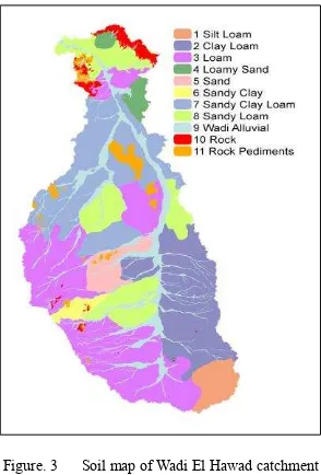
The same Landsat image data augmented with field data were used and catchment’s digital soil map (Figure. 3) having eleven units was produced. The soil map was reclassified and grouped into the five NRSC hydrologic soil groupings (HSGs) as required by SCS model.
Figure. 3 Soil map of Wadi El Hawad catchment
Major topographical features of landscape such as flood plains, mountains, valleys and flat lands were easily recognized from Digital Elevation Models (DEM). Shuttle Radar Topography Mission (SRTM) DEM 1 arc-second 30 meters pixel size with geodetic reference WGS84 EGM96 geoid data was used as environmental covariate data. DEM data were processed using Arc Hydro Tools under ArcGIS environment, and the following terrain variables were extracted slope, catchment and Sub-catchment boundaries and drainage lines. Wadi El Hawad catchment landscape was divided into five categories based on the DEM highlands, flat lands with very gentle slope, valley lands and undulated lands. The different derivatives were combined forming a GIS layer and was used for SCS model computations.
Rainfall data is highly scarce and spatially variable in semi-arid and arid areas. A single rain gauge was mounted in the centre of Wadi El Hawad catchment for the purpose of this study as the nearest available rain-gauge is about 120 km distant. Depth of a
five days rainfall event making a total of 50.2 mm was used as a rainfall input for the model. Thus for the purpose of model spatial computation, each pixel has assigned the same rainfall value as rainfall records was available from a single gauge. Besides gauged rain data, the satellite estimated rain data was used as another alternative for runoff estimation. The Tropical Rainfall Measuring Mission (TRMM) satellite rainfall data was the selected sensor for this study. TRMM has Precipitation Radar (PR) sensor which is designed to monitor and study tropical and subtropical rainfall. Five days storm data which is spatially distributed and having different rain values per pixel was used as a rainfall parameter in SCS for runoff estimation. Therefore two different rainfall volumes were estimated based on the different rainfall sources.
2.3. SCS Curve Number
The United States Department of Agriculture (USDA), National Resources Conservation Service formerly known by Soil Conservation Service (SCS) has developed a method which is popularly known as "SCS runoff curve number or CN" for computing direct surface runoff volume from rainfall excess. The CN is known to be an efficient method. The main parameters required to estimated surface runoff depth for the CN method are rainfall event, hydrological soil groups HSG which are taken from soil data, landcover/use and the catchment hydrologic condition including categorization and antecedent soil moisture condition AMC. Because of its simplicity, convenience and publicity it is frequently used in hydrology to estimate runoff resulting from event rainfall. The SCS uses traditional way for computing CN and runoff estimation that requires more time. Rainfall runoff relation in curve number method described as:
� =
�−��²�−��+� (1)
Q: estimated runoff depth (mm), P: rainfall event (mm), S: potential maximum soil moisture retention after the beginning of runoff,
�
�: initial abstractions (amount of water before runoff such as infiltration, interception).�
�= 0.2�
(2)�
� is defined as a percentage of S (2), with this assumption runoff equation is simplified to (3)� =
�− . � ²�+ .8S (3)Equation (3) written in only 3 variables. The parameter CN is a transformation of S, and it is used to make interpolating, averaging, and weighting operations more linear (4).
� =
��− 2
(4)For soil data to be used in CN model, NRCS has divided soils into four hydrologic soil groups (HSGs) A, B, C, and D based on infiltration capacity and rate of water transmission through the soil.
Group A: high infiltration rate and low runoff potential, good example is deep sand.
Group B: moderate infiltration and moderate runoff, example is sandy loam.
Group C: moderately high runoff potential, examples, clay loam, shallow sandy loam, soils low in organic content and soils high in clay.
Group D: impermeable of high runoff when thoroughly wet, heavy plastic clay soil. Land cover and HSGs.
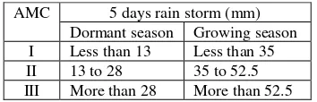
Runoff is also affected by antecedent moisture condition (AMC) which is the soil moisture before rainfall occurs and for the model purpose (AMC) are grouped into three conditions: AMC-1: low moisture (dry), II: average moisture condition and AMC-III: high moisture, heavily rainfall over proceeding few days (wet). Dry AMC-I and wet AMC-III conditions equivalent curve numbers computed as shown by (Table 1).
AMC 5 days rain storm (mm) Dormant season Growing season I Less than 13 Less than 35 II 13 to 28 35 to 52.5 III More than 28 More than 52.5
Table 1. Antecedent moisture conditions AMCs for determining CN
The calculated CN in this model used AMC-II (average soil moisture) to estimate the runoff. AMC-I and AMC-III can be computed from equations (5) and (6).
��
�=
− . 8 ��. ���� �� (5)��
���=
+ �������� (6)2.3 Geospatial CN Method
The tradition procedure of CN method results in lumped runoff value. The lumped value for spatially varied catchment is considered the main disadvantage of the CN method. In order to get runoff values based on spatial variability, the study has utilized the potentials of geo-spatial technology that is Geographical Information Systems (GIS) and remote sensing. Surface runoff volumes for each piece of area (pixel) in the catchment were computed based on the spatial variability of rainfall event, soil type and landuse/cover practice.
Model inputs were treated spatially in ArcGIS environment, all datasets were projected into UTM zone 36N, WGS 84 and become ready for spatial analysis. Soil and landcover were intersected, the combined landcover/soil units were assigned the relevant CN values. Two different rainfall events from different sources were fed into the model. The first rainfall data were taken from records of five days storm with total of 50.2 mm from the rain gauge station mounted at the catchment area. The gauged data was used as a rainfall input for the model and for the purpose
of model spatial computation, each pixel has assigned the same rainfall value. The second source of rainfall data is TRMM data which is a satellite image with each pixel holding the exact rainfall value detected by the sensor. So the computation of the runoff volumes using TRMM rainfall data gives real spatial data (Figure 4).
Figure 4. GIS based SCS CN method
Finally two different surface runoff volumes were computed for each grid depending on the two different rainfall sources, gauged and satellite TRMM data.
3. RESULTS
SCS model parameters and the catchment’s surface runoff were assessed and analysed based on results include Wadi El Hawad catchment digital soil map, landcover, terrain variables, GIS based spatially distributed CN and estimated surface runoff volume.
DEM data were processed using Arc Hydro Tools under ArcGIS environment and terrain variables, GIS layer comprising watershed, sub watershed boundaries, delineated drainage lines, slope and slope direction were generated. The different derivatives were combined forming a GIS layer and used in SCS model computations and spatial analysis. DEM was also used with other data sources such as Landsat image and field data in producing digital soil map for the catchment (Figure 3). The produced eleven classes’ soil map was reclassified into five hydrologic soil groups (HSG) in order to fulfil SCS model standards applicable for a soil as a model parameter (Table 2).
landcover
Table 2. Wadi El Hawad catchment lancover units, hydrologic soil groups (HSG), CN values and area%
Two rainfall scenarios from two different sources were fed into the model. The first rainfall data was taken from records of a single rain gauge station mounted at the catchment area. Depth of a five days rainfall event making a total of 50.2 mm was used as a rainfall input for the model. For the purpose of model spatial computation, each pixel has assigned value of 50.2 mm and runoff was estimated accordingly. The second source of rainfall data is a satellite borne. An attempt has been made in finding an alternatives to overcome the problem of ungauged catchment’s scarce data. Tropical Rainfall Measuring Mission (TRMM) satellite rainfall data was fed into SCS CN runoff model to estimate surface runoff. An accumulated five days satellite rainfall having mean 26.16 mm was used and geospatial analysis is performed under GIS environment and runoff was estimated for each pixel. Pixel values were ranging from 50.2 to 0 mm. Runoff values of each rainfall type were shown in (Table 3).
Cover type Area%
Table 3. Wadi El Hawad catchment runoff% based on rain-gauged and TRMM data
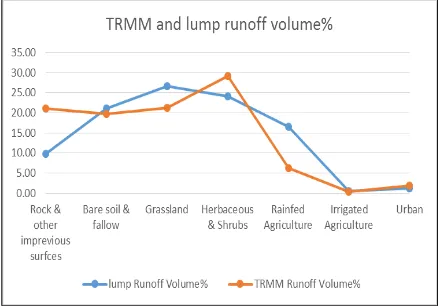
The spatial variability of satellite rainfall has resulted in runoff variations throughout the catchment area and TRMM and gauged yielded runoff variation shown by (Figure 5).
The variation in runoff values between TRMM and gauged rainfall data were remarkable in rock and other impervious areas and rainfed agriculture (Figure 6).
Figure 6. TRMM and gauged runoff variation
A sub-catchment of Wadi El Hawad catchment was investigated and assessed to evaluate runoff and water harvest potential. The sub-catchment characteristics were shown in below (Table 4 and Figure 7).
Area (Km²)
Weighted CN
Physiography Runoff (in)
Water Volume (M³)
41.8 83
undulated,
hilly & loamy 0.67 0.7 million
Table 4. Sub-catchment characteristics
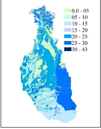
Figure 7. Sub-catchment runoff values (mm)
4. DISCUSSION
In this study two recent approaches were introduced to the tradition SCS CN method, model computations in a GIS environment rather than the tedious and time consuming approach practiced by traditional CN method and the introduction of satellite borne rainfall data as an alternative to the poorly gauged catchments rainfall records. As mentioned, gauged rainfall values were collected from a single point which in all means will not represent the large catchment under investigation. Although the data was still used for estimating catchment’s runoff value. Why? Because the nearest rainfall station to the entire catchment is 120 km distant besides, it could not be considered as a contributor to assess catchment rainfall as the area is semi-arid that characterized by locality and highly spatially varied type of rainfall. For these reasons and to
strengthen the model results the study had to find alternatives and other solutions. TRMM rainfall data had appeared to be the suitable alternative and solution. When TRMM data is merged with other products, the use of satellite-based products is better than the gridded rain gauge products that utilize sparse data for hydrological modeling at large scales (Daniele et al., 2015).
In (Figure 2) the graph shows some variations in runoff volumes between the TRMM and the raingauged data. The raingauged runoff showed smooth curve because of using the same amount of rainfall value everywhere all over the catchment, while the TRMM showed a variated curve which is more realistic runoff shape due to semi-arid nature of erratic and variated rainfall. Rock and other impervious surfaces cover showed the highest variation in runoff amounts between TRMM and gauged and this was due to TRMM spatially distributed rainfall. Rock and other impervious surfaces although they cover only 1.6% of the catchment’s area their runoff yields were about 10% and 21% respectively of total runoff volume (Table 3). The high runoff volume yields and the confined drainage shapes gives the possibility of constructing water harvesting entities within this category such as dams. The biggest contributor to runoff in the catchment is the grassland category reference to the gauged rainfall data. Grassland covers about 53% of the catchment area and contributes with 26.7% (gauged) and 21.3% (TRMM) of total runoff volume. Regarding the potentiality of runoff this class was classified as a very low potential because this runoff value was only due to the large area coverage. The poor drainage network of the grassland areas due to the flat slope also augments the argument and making it not suitable for constructing dams but highly conducive for the other type of water harvesting system which is hafir because the structure of hafir requires very small amount of water and mild runoff to avoid sedimentation as hafir is a small pond that is easily to be filled with water and sediments.
As well known in hydrology agriculture is in many cases plays as an important factor that accelerates runoff. The situation in Wadi El Hawad catchment is different. The type of rainfed cultivation practiced in the catchment is dependent on terraces that keep the rain water confined to the farms and hence reducing the total runoff in the catchment. Agriculture is expected to expand seriously in future because people still practicing traditional style of cultivation which includes low productive varieties, zero fertilizers and vertical production intensification. Therefore future runoff volumes from these areas tend to decrease. Shrubs and herbaceous are covering about 28% of the total area of the catchment and yields about 24% of total runoff. In the northern part the flat slope and the top sandy soil cover were hindering the generation of runoff within this area and not allowing the coming runoff to cross the area to reach the main wadi course.
of harvested water in confined dams can survive up to the end of the year. Most of Sub-catchments having the same conditions are considered potential for water harvesting projects.
The yielded runoff estimations from both rainfall types indicate that there is possibility of getting benefit out of these runoff volumes under some certain conditions although the catchment is under semi-arid condition. Early maturing rainfed light crops cultivation could be practiced using terraces to harvest the running water. Small and confined dams and other water collected methods like hafir could be constructed, The Dams has to be constructed in areas where soil and geology will accommodate such as impermeable soil and confined wadis not the broader ones.
5. CONCLUSION
Most of the population of the catchment depends on practicing small farm traditional rainfed cultivation and raising animals that graze on the poor rangelands of the catchment. The main source of drinking water for both human and animals in the catchment is the surface runoff. Therefore there is a tendency of practicing water harvest. In this context knowledge is required for making better water management and conservation decisions. Water harvest potential investigation performed on the Sub-catchment represents a baseline database for this catchment and the similar catchments in semi-arid areas of central Sudan and it could be used for further studies. The study reveals that the SCS-CN model can be used to estimate surface runoff depth when adequate hydrological information is not available. TRMM rainfall data has proved to be an alternative for rainfall records in such ungauged catchments.
6. REFERENCES
Al-Weshah, R. A. and El-Khoury, F. 1999. Flood analysis and mitigation for Petra area in Jordan. ASCE Journal of Water Resources Planning and Management, May/June, 170–77. Bromley, J., Butterworth, J. A., Macdonald, D. M. J., Lovell, C. J., Mharapara, I. and Batchelor, C. H.1999. Hydrological processes and water resources management in a dryland environment I: An introduction to the Romwe Catchment Study in Southern Zimbabwe. Hydrology and Earth System Sciences, 3(3), 322-332, ©EGS.
Chatterjee, S., Krishna, A.P., Sharma, A. P. 2016. Spatio-temporal runoff estimation using TRMM satellite data and NRSC-CN method of a watershed of Upper Subarnarekha River basin, India. Arabian Journal of Geosciences 9:5.
Daniele, N., Zed, Z., Li-Pen, W., Christian, O., Wouter, B., Waldo, L. C., Jean, L. G. 2015. A Comparative Analysis of TRMM–Rain Gauge Data Merging Techniques at the Daily Time Scale for Distributed Rainfall–Runoff Modeling Applications. American Meteorological Society. DOI: http://dx.doi.org/10.1175/JHM-D-14-0197.1
Diek, S., Temme, A.J.A.M., Teuling, A.J. 2014. The effect of spatial soil variation on the hydrology of a semi-arid Rocky Mountains catchment. Geoderma s (235–236):113–126. Harrison, M. N., and Jackson, J. K. 1958. Ecological Classification of the Vegetation of the Sudan. Forests Bulletin. Volume (2): 1-45
Li, F., Zhang, Y., Xu, Z., Liu, W. 2014. Runoff predictions in ungauged catchments in southeast Tibetan Plateau. Journal of Hydrology (511):28–38
Mango, L. M., Melesse, A. M., McClain, M. E. Gann, D. and Setegn S.G. 2011. Interactive comment on “A modeling approach to determine the impacts of land use and climate change scenarios on the water flux of the upper Mara River. International Journal of Advancement in Earth and Environmental Sciences. Discuss. (7): C4529–C4533.
Mohamed A. M. A., Eltayeb O. Adam, Khalid A. A. Abutalib., Ohja, C. S. P. 2014. Validation of satellite-based rainfall measurements in arid and semi-arid regions of Sudan. Conference: 10th international conference of the African association of remote sensing of the environment, at university of Johannesburg, South Africa. DOI: 10.13140/2.1.1024.3368
Moore, I. D., R. B. Grayson, and A. R. Ladson, 1991. Digital terrain modelling: A review of hydrological, geomorphological and biological applications, Hydrological Processes. ( 5): 3–30 Obeid, M. and Mahmoud, A. 1971. Ecological Studies in the Vegetation of the Sudan: II. The Ecological Relationships of the Vegetation of Khartoum Province. Vegetatio Vol. 23, No. 3/4 pp. 177-198.
Salih, Abdin. M. A. and Ghanem, Ashraf. H. M. 2002. Sustainable management of wadi systems: Chapter 9. Hydrology of Wadi systems: Technical Documents in Hydrology. No. 55 UNESCO, Paris.
SCS, 1972. National engineering handbook, sec. 4: hydrology, soil conservation service (SCS). USDA, Washington, D.C.
Sen, Z. 2008. Wadi Hydrology. 1st edition. Florida: CRC Press. ISBN: 978-1-42006154-3; 347 pp.
Shaheed, S. and Almasri, M. 2010. Application of GIS-based SCS-CN method in West Bank catchments, Palestine. Water Science and Engineering, (3), (1): 1-13.
Shahin, M. 2007. Water Resources and Hydrometeorology of the Arab Region. Water Science and Technology Library. Volume (59). Springer
Wheater, H.S. and Al-Weshah, R.A. 2002. Hydrology of Wadi systems. International Hydrological Programme: IHP regional network on wadi hydrology in the Arab region. IHP-V. Technical Documents in Hydrology. No. 55 UNESCO, Paris.
Wheater, H.S., Sorooshian, S., Sharma, K. D. 2007. Hydrological Modelling in Arid and Semi-Arid Areas. Camberge University Press. ISBN: 9780521869188.