CR-Form-v3
CHANGE REQUEST
WCS
CR ?
rev
-
Current version:
1.1.1
For
HELP
on using this form, see bottom of this page or look at the pop-up text over the
symbols.
Proposed change affects:
AS
Imp Spec
X
Best Practices Paper
Other
Title:
WCS change request - Allow non-georeferenced images
Source:
Arliss Whiteside, WCS 1.2 RWG
Work item code:
Date:
2008-01-27
2007-11-20
Category:
F
(Add needed information)
Use one of the following categories:
F (Critical correction)
A (corresponds to a correction in an earlier release)
B (Addition of feature),
C (Functional modification of feature)
D (Editorial modification)
Reason for change:
WCS 1.1.0 and 1.1.1 define use cases 3 and 8 that both require the ability to
serve non-georeferenced (and thus not georectified) images and other grid
coverages. However by mistake, the specified lists of SupportedCRS
elements in a CoverageDescription and a CoverageSummary do not now
allow these lists be emptyrequire that these lists include the ImageCRS of an
unrectified image
, and thus
do not
allow serving a non-georeferenced image
only directly in its ImageCRS.
Summary of change:
Modify the specification of lists of SupportedCRS elements in a
Consequences if
not approved:
Continued WCS
inability limited ability
to serve non-georeferenced (and thus
not georectified) images and other grid coverages
Clauses affected:
8.3.3.2, 9.3.1.1, wcsContents.xsd, wcsDescribeCoverage.xsd
Other specs
Other core specifications
Affected:
Abstract specifications
Best Practices Papers
Supporting Doc.
Other comments:
This change request is to the approved WCS version 1.1.1 [OGC 07-067r2].
Status
Disposition
Edit Tables 5 and 6 in Subclause 8.3.3.2 of the WCS specification as
follows:
Names
aDefinition
Data type
Multiplicity and use
(Description)
bDescription of a coverage
Description data
structure, see
[OGC 06-121r3]
One (mandatory)
bmetadata
Metadata
More metadata about this
coverage
Metadata data
structure, see
[OGC 06-121r3]
Zero or more (optional)
Include when useful
wgs84 Bounding Box
WGS84 Bounding Box
Minimum bounding
rectangle surrounding
coverage, using WGS
84 CRS with decimal
degrees and longitude
before latitude
WGS84Bounding-Box, see
Subclause 10.2 in
OGC 06-121r3
Zero or more (optional)
Include when useful or
needed
dresponse outputs
may
be expressed
URI
Zero or more (optional)
e, fInclude one for each
GridBase
CRS supported
supported Format
Supported Format
Identifier of format in
which GetCoverage
operation response may
be encoded
Character String
type, not empty
(ows:MimeType)
Zero or more (optional)
e, fInclude one for each format
supported
identifier
Identifier
cUnambiguous identifier
of this coverage, unique
for this WCS server.
Character String
type, not empty
Zero or one (optional)
Include when this coverage
is available for
DescribeCoverage and
GetCoverage requests
gcoverage Summary
data structure, see
this table
Zero or more (optional)
One for each subsidiary
coverage, unordered
fa See Table 1 of [OGC 06-121r3] for UML and XML naming conventions. b Contents inherited, not included as a named data structure.
c Values are identifiers in Contents section of GetCapabilities operation response. When the Capabilities XML document does not have any CoverageSummary sections, clients must obtain a valid coverage identifier from another source, such as a catalog service. d This WGS84BoundingBox may be approximate, but should be as precise as practical. When multiple WGS84 bounding boxes are included, this shall be interpreted as the union (or combination) of the areas of these bounding boxes. Table 6 below specifies when a WGS84BoundingBox is needed. Currently, this WCS specification provides no way for a server to specify the precision of a bounding box.
e When included, this list, including all values inherited from ancestor coverages, shall be an exact copy of the equivalent parameters in the CoverageDescription. Each CoverageSummary shall list or inherit at least one supportedCRS SupportedCRS and one supportedFormatSupportedFormat.The ImageCRS of an unrectified offered image usually should be listed as a , so that it. an unrectified offered coverage, instead of in a specified GridCRS
f There may be a dependency of SupportedCRS on SupportedFormat as described in Subclause 10.3.5.
f A SupportedCRS may be referenced as the GridBaseCRS of a GridCRS specified in the Output part of a GetCoverage request.SupportedCRS . In addition, the GetCoverage operation output may be expressed in the ImageCRS of an unrectified offered coveragemay be referenced as the baseCRS of a GridCRS In addition, the GetCoverage operation output may be expressed in the ImageCRS of an unrectified offered coverage, instead of in a GridCRS. These SupportedCRSs may also be referenced in the BoundingBox in the DomainSubset part of a GetCoverage request.
g This Identifier shall be included unless one or more CoverageSummaries are included. When one or more CoverageSummaries are included, inclusion of the Identifier is optional.
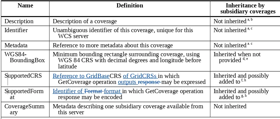
Table 6 — Inheritance of parts of CoverageSummary data structure
Name
Definition
Inheritance by
subsidiary coverages
Description
Description of a coverage
Not inherited
a, bIdentifier
Unambiguous identifier of this coverage, unique for this
WCS server
Not inherited
a, c
Metadata
Reference to more metadata about this coverage
Not inherited
a. cWGS84-BoundingBox
Minimum bounding rectangle surrounding coverage, using
WGS 84 CRS with decimal degrees and longitude before
latitude
Inherited when not
provided
d, eSupportedCRS
Reference to GridBase
CRS
of Grid
CRSs
in which
GetCoverage operation
outputs response
may be expressed
Inherited and possibly
added to
f, hSupported Form
at
Identifier of Format format
response may be encoded
in which GetCoverage operation
Inherited and possibly
added to
g, hCoverage Summ
ary
Metadata describing one subsidiary coverage available from
this server
Not inherited
a Although these parameters are not inherited by a subsidiary coverage, the values of these parameters for all higher levels in a hierarchy of coverages may be relevant and are available to clients.
b A value for this mandatory parameter shall be provided at all levels in the hierarchy. c Values for these optional parameters may be provided at all levels in the hierarchy.
d When no value is provided for a coverage, any value recorded for a higher level in a hierarchy of coverages shall apply to this coverage. When a value is provided for a coverage, it overrides any value recorded for a higher level in a hierarchy of coverages. e For each ”leaf” CoverageSummary, at least one WGS84BoundingBox shall be either recorded or inherited, for each georectified or georeferenced coverage. (This WGS84BoundingBox is included to simplify searching for coverages that might overlap a specified region.)
f The full list of CRSs supported by a coverage shall be the union of the CoverageSummary’s own supportedCRSs SupportedCRSs
and those supported by all its parent ancestor CoverageSummaries. These SupportedCRSs can be referenced as the baseCRS of a GridCRS specified in the Ouput part of a GetCoverage request. In addition, the GetCoverage operation response may be expressed in the ImageCRS of each offered unrectified coverage, which shall not be referenced here. These SupportedCRSs can also be referenced in the BoundingBox in the DomainSubset part of a GetCoverage request.
g The full list of formats supported by a coverage shall be the union of the CoverageSummary’s own supportedFormats SupportedFormats and those supported by all its parent ancestor CoverageSummaries.
Edit fragment of wcsContents.xsd as follows:
<complexType name="CoverageSummaryType">
<annotation>
<documentation>Brief metadata describing one or more coverages
available from this WCS server. </documentation>
</annotation>
<complexContent>
<extension base="ows:DescriptionType">
<sequence>
<element ref="ows:Metadata" minOccurs="0"
maxOccurs="unbounded">
<annotation>
<documentation>Optional unordered list of more
metadata elements about this coverage. A list of metadata elements for
CoverageSummaries could be specified in a WCS Application Profile.
</documentation>
</annotation>
</element>
<element ref="ows:WGS84BoundingBox" minOccurs="0"
maxOccurs="unbounded">
<annotation>
<documentation>Unordered list of minimum bounding
rectangles surrounding coverage data, using WGS 84 CRS with decimal degrees
and longitude before latitude. These bounding boxes shall also apply to
lower-level CoverageSummaries under this CoverageSummary, unless other
bounding boxes are specified. </documentation>
</annotation>
</element>
<element name="SupportedCRS" type="anyURI" minOccurs="0"
maxOccurs="unbounded">
<annotation>
<documentation>Unordered list of references to
CRSs
that may be referenced as a GridBaseCRS of a GridCRS in the Output part
of a GetCoverage request.
CRSs in which GetCoverage operation requests and
responses may be expressed.
These CRSs shall also apply to all lower-level
CoverageSummaries under this CoverageSummary, in addition to any other CRSs
referenced.
When included in a CoverageSummary with an Identifier, this
list, including all values inherited from ancestor coverages, shall be
an exact copy of the list of SupportedCRS parameters in the
corresponding CoverageDescription. Each CoverageSummary shall list or
inherit at least one SupportedCRS.
</documentation>
</annotation>
</element>
<element name="SupportedFormat" type="ows:MimeType"
minOccurs="0" maxOccurs="unbounded">
<annotation>
<documentation>Unordered list of identifiers of
formats in which GetCoverage operation responses may be encoded. These
formats shall also apply to all lower-level CoverageSummaries under this
CoverageSummary, in addition to any other formats identified.
When included
in a CoverageSummary with an Identifier, this list, including all values
inherited from ancestor coverages, shall be an exact copy of the list of
SupportedFormat parameters in the corresponding CoverageDescription.
Each CoverageSummary shall list or inherit at least one SupportedFormat.
</documentation>
</annotation>
</element>
<choice>
<annotation>
<documentation>Each coverage summary shall contain
one or more lower-level CoverageSummaries and/or one identifier.
</documentation>
</annotation>
<sequence>
<element ref="wcs:CoverageSummary"
maxOccurs="unbounded">
<annotation>
<documentation>Unordered list of lower-level
CoverageSummaries under this CoverageSummary. </documentation>
</annotation>
</element>
<element ref="wcs:Identifier" minOccurs="0">
<annotation>
<documentation>Optional identifier of this
coverage. This identifier shall be included only when this coverage can be
accessed by the GetCoverage operation, and the CoverageDescription can be
accessed by the DescribeCoverage operation. This identifier must be unique
for this WCS server. </documentation>
</annotation>
</element>
</sequence>
<element ref="wcs:Identifier">
<annotation>
<documentation>Identifier of this coverage. This
identifier must be unique for this WCS server. </documentation>
</annotation>
</element>
Edit Tables 10 and 12 in Subclause 9.3.1.1 of the WCS specification as
follows:
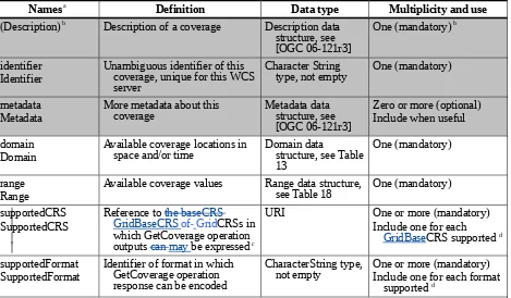
Table 10 — Parts of CoverageDescription data structure
Names
aDefinition
Data type
Multiplicity and use
(Description)
bDescription of a coverage
Description data
structure, see
[OGC 06-121r3]
One (mandatory)
bidentifier
Identifier
Unambiguous identifier of this
coverage, unique for this WCS
server
Character String
type, not empty
One (mandatory)
metadata
Metadata
More metadata about this
coverage
Metadata data
structure, see
[OGC 06-121r3]
Zero or more (optional)
Include when useful
domain
Domain
Available coverage locations in
space and/or time
Domain data
structure, see Table
13
One (mandatory)
range
Range
Available coverage values
Range data structure,
see Table 18
One (mandatory)
supportedCRS
SupportedCRS
Reference to
the baseCRS
GridBaseCRS
of
GridCRSs in
which GetCoverage operation
outputs
can may
be expressed
cURI
One or more (mandatory)
Include one for each
GridBase
CRS supported
dsupportedFormat
SupportedFormat
Identifier of format in which
GetCoverage operation
response can be encoded
CharacterString type,
not empty
One or more (mandatory)
Include one for each format
supported
da See Table 1 of [OGC 06-121r3] for UML and XML naming conventions.
b Contents inherited, not included as a named data structure. Normally includes only one Metadata item, but may include more than one when used here, especially for an unrectified but georeferenced image coverage.
c These A SupportedCRSscan may be referenced as the baseCRS GridBaseCRS of a GridCRS specified in the Output part of a GetCoverage request. The GridBaseCRS of the GridCRS of a georectified offered coverage shall be listed as a SupportedCRS. An ImageCRS for an unrectified offered image shall be listed as a SupportedCRS, so that it may be referenced as the GridBaseCRS of a GridCRS. This ImageCRS shall be the ImageCRS of that unrectified offered image, or the ImageCRS that is referenced as the GridBaseCRS of the GridCRS that is used by that unrectified offered image In addition, the GetCoverage operation output Alternately, the GetCoverage operation output can may be expressed in the ImageCRS or GridCRS of the an unrectified offered coverage, instead of in a specified GridCRS. These SupportedCRSs can also be referenced in the BoundingBox in the DomainSubset part of a GetCoverage request.
d There may be a dependency of a SupportedCRS upon a SupportedFormat: see Subclause 10.3.5Error: Reference source not found.
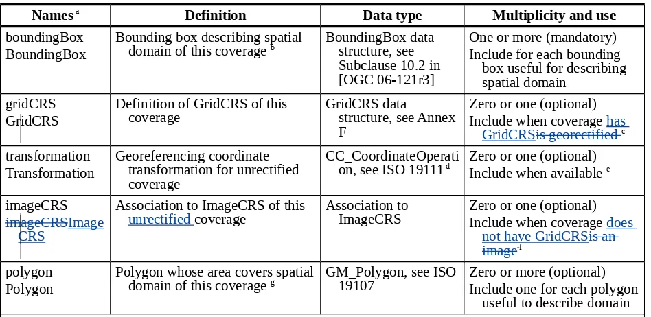
Table 12
— Parts of SpatialDomain data structure
Names
aDefinition
Data type
Multiplicity and use
boundingBox
BoundingBox
Bounding box describing spatial
domain of this coverage
bBoundingBox data
structure, see
Subclause 10.2 in
[OGC 06-121r3]
One or more (mandatory)
Include for each bounding
box useful for describing
spatial domain
gridCRS
GridCRS
Definition of GridCRS of this
coverage
GridCRS data
structure, see Annex
F
Zero or one (optional)
Include when coverage
has
GridCRSis georectified
ctransformation
Transformation
Georeferencing coordinate
transformation for unrectified
coverage
CC_CoordinateOperati
on, see ISO 19111
dZero or one (optional)
Include when available
eimageCRS
imageCRSImage
CRS
Association to ImageCRS of this
unrectified
coverage
Association to
ImageCRS
Zero or one (optional)
Include when coverage
does
not have GridCRSis an
image
fpolygon
Polygon
Polygon whose area covers spatial
domain of this coverage
gGM_Polygon, see ISO
19107
Zero or more (optional)
Include one for each polygon
useful to describe domain
a See Table 1 of [OGC 06-121r3] for UML and XML naming conventions.b The first bounding box shall exactly specify the spatial domain of the (one offered) CRS of the offered coverage, thus specifying the available grid row and column indices. For a georectified coverage (that has a GridCRS), this bounding box shall specify the spatial domain in that GridCRS. For an image that is not georectified, this bounding box shall specify the spatial domain in the ImageCRS or GridCRS of that image, whether or not that image is georeferenced.
Additional bounding boxes, if any, shall specify the spatial domain in other CRSs. These additional bounding boxes may be approximate, but should be as accurate as practical. One bounding box could simply duplicate the information in the
ows:WGS84BoundingBox in the CoverageSummary; but the intent is to describe the spatial domain in more detail (e.g., in several different CRSs, or several rectangular areas instead of one overall bounding box). Multiple bounding boxes with the same CRS shall be interpreted as an unordered list of bounding boxes whose union covers spatial domain of this coverage. WCS use of this BoundingBox is further specified in specification Subclause 7.6.
c This GridCRS shall be included in the SpatialDomain when the offered coverage is georectified and thus has a GridCRS. A georectified coverage shall always have a GridCRS. An unrectified image may have a known GridCRS that has an ImageCRS as its GridBaseCRS. This GridCRS applies to this offered coverage, and specifies its spatial resolution in its GridBaseCRS.
d This CoordinateOperation can be a Transformation or a ConcatenatedOperation that includes at least one Transformation. e A Transformation that is a georeferencing coordinate transformation for an unrectified offered coverage should be included in the SpatialDomain when available and the coverage is georeferenced but not georectified. When included, this Transformation will specify the variable spatial resolution of this non-georectified image. To support use cases 4, 5, 9, or 10 specified in Annex G, a WCS server needs to use a georeferencing coordinate transformation for a coverage that is georeferenced but not georectified. However, a WCS server may opt not to support those use cases, or to use other means (such as a linked metadata file) to convey the georeferencing transformation, or not to make that transformation available to clients at all. Conversely, a client may opt to ignore any Transformation and to treat such a coverage as a non-georeferenced coverage (or to obtain the transformation by some other means).
f The iImageCRS shall be referenced in the SpatialDomain when the offered coverage does not have a known GridCRSis an image.
Such a coverage is always unrectified, but an unrectified coverage may have a GridCRS instead of an ImageCRS. This iImageCRS applies to this offered coverage, but does not (normally) specify its spatial resolution. The ImageCRS and the GridCRS shall be mutually exclusive in this SpatialDomain.