A method of 3D-GIS application aided with stereo panorama technology
Sun M.a Dong N.a Zheng H.b Jiang C.a Ren X.a
a. Institute of RS&GIS, Peking University, Beijing, China, 100871, [email protected]
b. China University of Mining &Technology, Beijing, China, 100083
KEY WORDS: Stereo, Measurement, 3D-GIS, Acquisition, Update, Application
ABSTRACT:
So far, three-dimensional geographic information system (3DGIS) has been developed and applied to many fields. However, data
capturing is a challenge for complex environment modeling and visualization. Panorama is an elegant method for users to get a real
view without being plagued by 3D measurement and modeling. Although someone claimed that panoramas can offer the function of
measurement, the results are widely considered not reliable. 3D images composited by laser scanner data are another kind of precise
data source to replace traditional 3D modeling. Laser scanners have obvious shortcomings, such as vast data and time-consuming
processes. We propose a method of using stereo panorama technology to complement the three-dimensional data acquisition,
processing and management. By using two cameras combined with MTI sensors, which provide pose and position measurement. We
can obtain the stereo panorama at one time, which enables users to measure positions and orientations of particular features. The
panorama can be uploaded to the 3D-GIS in a custom transmission format to provide stereo browsing of data capture sites. Combined
with photogrammetry technology, users can also get accurate results by measuring interesting features on the panorama through
interactive measurement interface. Based on Google Earth platform, we verified the effectiveness of our developed system. It stands
out from traditional methods with its irreplaceable superiority in local 3D data acquisition and updating, as well as its direct data
measurement.
1. INTRODUCTION
The purpose of 3D geographic information construction is
mainly to provide users with a digital and life-like
information space, in which users can analyze and process
spatial information to get results of relative applications.
However, data are in large demand when constructing a
3D-GIS, especially when we need to build detailed 3D
models for better visual effects. In general, this process of
data gathering and model building requires a lot of human
and material resources. Moreover, the data updating
afterwards is more complicated than that of a traditional
geographic information system. The complex work is not
simplified even when it only implements simple functions
like browse and query without complicated special analysis.
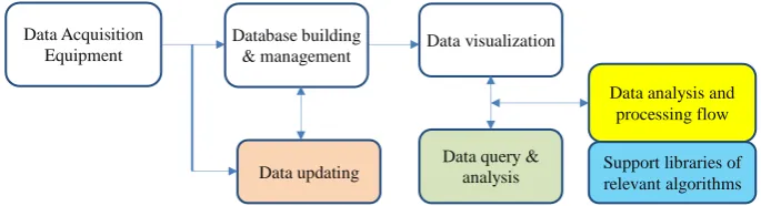
To solve this problem, we proposed a method of replacing the
modeling, query and data updating processes in a traditional
3D-GIS by 3D panoramic models in complicated and
important sites. This method takes advantages of real-time
Figure 1. Traditional data processing of a 3D geographic information system
Figure 2. Data processing of a 3D geographic information system proposed in this essay
The method we proposed is superior to traditional ones in
following aspects:
1) Data gathered are stored and managed in database
directly without analysis, processing or complicated 3D modeling. It’s meaningful to the current embarrassing situation of costly huge database building but few data
usage.
2) Data updating is clear and concise. What we need to do
is only data re-gathering with relevant equipment,
regardless of complicated factors and processes in
traditional spatial database updating.
3) This method is directly based on digital image data, so
spatial vector data management and processing are
reduced. Accordingly, the system is simplified, and the
up-to-data state and the effectiveness of information
updating are improved.
panorama refactoring in Section 3. In section 4, we state the
core content of this essay, the construction of a 3D-GIS
integrated with stereo panoramas.
2.
RELEVANT RESEARCH
It is widely studied over the years to introduce panorama
images into 3D-GISs (or GISs), and there are many related
commercial software systems, among which the panorama
application of Google Earth is most popular. With this
application, users can browse real sites, which to some
degree are immersive [1]. In China, there are also many
so-called 3D panorama GISs, such as Roctec [2] and
Mapscene [3]. They claim that their systems have integrated
panorama images into 3D-GIS, and users can not only
browse panorama images continuously, but also do 3D object
measurement. The main theory contains two aspects: 1)
Match 3D point cloud obtained by laser scanners with images
to get 3D images, as is stated in [11]; 2) Implement the
measuring function by taking advantages of regular shapes on
images and foregone constraint conditions. For the former,
the aim of quick and real-time measurement is hard to
achieve due to high-cost data acquisition and complicated
data processing. For the later, measurement accuracy is not
credible, so the results are for reference only.
Some companies in the world have built a kind of virtual
image browsing system combined with GIS or Google Earth,
which is based on large numbers of outdoor travelling images
and aims to realize virtual tourism. For example, Panoramic
Earth offers a growing collection of 360° panoramas showing
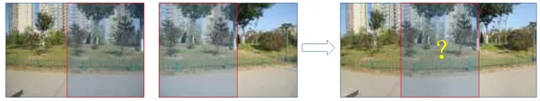
Data Acquisition
Figure 3. It’s hard to decide the exact relation between original and merged images.
the wonders of earth with free virtual tour hosting to
panoramic photographers. Graphics and Imaging Lab in
University of Washington develops a system called Photo
Tourism (Noah, 2007). It is a system for browsing large
collections of photographs in 3D. Each photo either from
personal photo collections or from Internet photo sharing
sites is automatically computed to get its viewport and to
construct a sparse 3D model of the scene. Its photo explorer
interface enables the viewer to interactively move about the
3D space by seamlessly transitioning between photographs.
In the GIS world, some scholars have put forward the
concept of digital measurable images(LI, 2007), while in the
world of photogrammetry, 3D object rebuilding methods
based on cylindrical panorama have been discussed, in which
data are processed in traditional photogrammetry way and
measured objects are determined through man-machine
interactions(Luhmann, 2004).
Fangi et al. researched 3D rebuilding under globular
projection, and put forward the collinearity equation and the
coplanarity equation under globular expression. But in
practical calculation, they finished 3D rebuilding of buildings
with the help of large numbers of control points and the
bundle adjustment method (Fangi, 2007,2009,2010). In
summary, the main purpose of these work is to realize the
whole rebuilding of 3D object models through constructing
panorama images. So it still costs a lot of resources.
Data accuracy is an important evaluation index for GIS
applications, and in general rule, the precision should be
without any doubt. So in this essay, we have a different
purpose, to offer users not only good virtual presentation
effects but also high-precision measuring results, so that we
can meet professional users’ demand.
3. MEASUREMENT OF STEREO
PANORAMA
Based on stereo image pairs, users are able to attain 3D
position of any object by stereo measurement. When this
image pair is combined with real geo-reference, it can
provide spatial coordinate of feature points, and reach the
target of measure and analyzing objects with interactive
operations.
The difference between stereo panorama and traditional
photogrammetry is that every feature point of traditional
photogrammetry has certain image frame and image center;
but when it comes to stereo panorama, the progress of image
stitching will make some image frame information lost, so it’s impossible to measure according the original images’ frame and center.
Figure 4. Two different ways to make panorama.
?
There are two ways to make panorama: one is the camera has
a fixed position and turn 360° to take photos(Figure 4A);
another way is the camera moves along the focal plane (most
used in street view images, Figure 4B).
It’s obvious that the first way is not suitable to build stereo
panorama, and the second way also has some shortages, such
as camera mush move along a straight line, the interval must
be equally divided .etc. When we want to get the positions of
targets far from the station on the image high-precision
results would be carried out after we set camera shooting
routes properly and take pictures at suitable intervals by
using 4.b method. In this article, we use the way showed in
figure 4.b to make stereo panorama image sequence.
The way showed in figure 5.b is similar to that in figure4b.
We must consider relative offset and rotation between
adjacent image pairs. There will be more fault if only
consider rotation like building traditional panorama.
In order solve this problem, we built a specialized device, as
is showed in figure 6, this device contains two same cameras,
and can provide accurate distance between the two cameras
measured by mm. An MTi motion tracker is used to attain the
3D pose and position of the device in real time. The angular
accuracy of this motion tracker is less than 1° , positioning
accuracy is less than 10m.
Figure 6. A specialized device we built to build stereo
On the other hand, we can synchronize the two cameras in
rotation and exposure. When doing measurements on the
processed stereo panorama, we can ignore the rotation of
baseline, then convert to unitized coordinate system. To make
the problem simple, the original point of coordinate system is
the center of baseline, x-axis is the same as north direction
provided by MTi, y-axis and z-axis are decided by
right-hand-thread rule.
Traditional photogrammetry method is used in the
measurement of certain point, we can calculate 3D position
of certain point using baseline’s length and optical parallax.
Because this process takes a very short time, we can realize
real-time measurement and spatial analyze. The detailed
process is showed in Figure 7.
4.
3D GIS INTEGRATED WITH
STEREO PANORAMAS
3D-GISs are generally considered as an extension of
2D-GISs in the third dimension. The relevant data model was
once widely researched, but till now, there is no 3D-GIS in
true sense. The main reason for it is the difficulty of setting
up the 3D topological relation. In fact, the 3D topological
relation is not in urgent demand in practical daily life, so
many existing 3D-GISs, as well as some prevalent software
like skyline, ArcGlobe, and EarthVision, mainly offer
functions like browse, query and simple topology analysis.
Although Google Earth has never claimed itself as a 3D-GIS,
it has no essential difference from the specialty software
listed above. Moreover, Google Earth has a larger group of
users relevant to geography. Map World of China is another
good example.
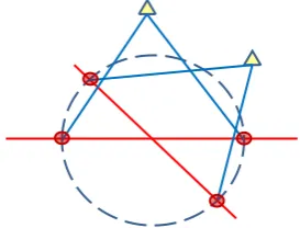
Therefore, in this essay, we are not going to define 3D-GIS as Figure 5.a. Rotate 360°at 2 different points.
Optical parallaxes are different for different
direction.
Figure 5.b. Two cameras rotate around a
certain baseline’s center. Optical parallaxes
are changeless.
Camera
Baseline and rotate
platform with
measurement.
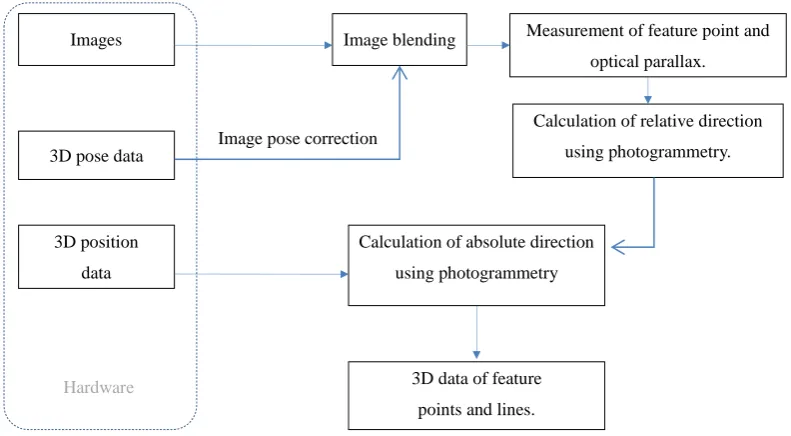
Figure 7. Workflow of building stereo panorama.
strict as that of tradition, but to call all software systems this
name that express real environment, and provide users with
information browse, query and analysis functions. Thus, in
our definition, Google Earth is very good software of 3D-GIS.
In addition, it is also the earliest non-professional GIS
integrated with panoramas.
As is mentioned in Section 1, it is of great significance to
replace complicated modeling by image sequences in
depicting complex outdoor sites. The visualization effect of
Google Earth panoramas is analogous to that of traditional
3D visualization methods in the aspect of browse, and there
is no landscape distortion in any representing process.
However after all, panoramas lack digital 3D information, so
users cannot obtain spatial geometrical information, the main
characteristic of GIS. In order to supply the gap, we introduce
stereo panoramas into 3D-GIS. With the support of a
background program, measuring operation of stereo
panoramas is implemented, so that geographic information
and spatial geometrical information of browsed objects are
available when users are viewing panoramas.
In this essay, we regard Google Earth as a platform of
3D-GIS. Measurable stereo panoramas are linked to it by
adding landmarks. Users can click interesting landmarks to
activate the plug-in program for stereo panorama browse and
measurement. It is in charge of the measurement and analysis
operations. The method of integrating panoramas into Google
Earth is detailed as follows:
1. Collect data of interesting spots outdoors with stereo
panorama equipment. The data we need include: stereo
panorama image sequences, 3D coordinates of the
observation stations, orientations, and posture information of
the image sequences;
2. The data we obtained are mainly images, so we choose
the management style of file systems. For example, we can
use Google file search engine to query original information
quickly;
3. Synthesize stereo panoramas with the method stated in
Section 3;
4. Generate kml files automatically with 3D positions and
orientations we get in step 1 after brief arrangement;
5. Start the 3D-GIS (Google Earth in this essay, and other
3D GISs should implement the data-reading interface and the
display module). The system reads in the information of
stereo panorama image sequences, and then display them in
the way of panorama landmarks on the visual interface;
6. Click the interesting panorama landmarks and their
information is displayed in detail, such as: the images of
shooting sites, shooting time, shooting-related personnel,
names and related information of important land features
(these data should be recorded in step 1);
7. Activate the plug-in program of stereo panorama
measurement through the landmark linkage if users need
more 3D information. Stereo browse and geometrical
information measurement and analysis are available on the
plug-in program interface;
8. Return to the 3D geographic information system after Images
3D position
data
Image blending Measurement of feature point and optical parallax.
Calculation of relative direction
using photogrammetry. 3D pose data
Image pose correction
Calculation of absolute direction
using photogrammetry
3D data of feature
points and lines.
all the related work.
Google Earth has integrated many streetscapes (stereo
panoramas) and implemented good browse functions, but
these stereo panoramas lack immersion senses, as well as
spatial measuring functions. The wok in the essay can well
supply this gap.
5. EXPERIMENT
In order to validate the practicability and operability of the
stereo panorama integrated 3D GIS we carried out an
experiment along the north shore of the Qinhe River with the
device we have made to acquire the stereo image sequences.
a) Stereo image acquisition
Before data acquisition, we must do the preparation work of
choosing the shooting route according to the image
requirement. The shooting route should be as flat as
possible to decrease the bend of the image sequence. To
keep the brightness of the left image and the right in the
same level the two cameras are adjusted properly to the
same exposure settings. Also they are fixed stably at the
same horizontal plane to avoid the vertical parallax in the
synthetic stereo panorama. When taking pictures, the
camera optical axes of the cameras in consecutive positions
are kept parallel as far as possible. The fixed MTI on the
camera holder is synchronous with the cameras and keep
parallel to the optical axis of the two cameras so that more
accurate posture data would be got to make a closer
direction recovery (Figure 8).
The first step is to take calibration images to carry out the
intrinsic parameters of the two shooting cameras. Then we
take images with 30 degree interval in all directions to
collect a panorama image sequence of each fixed position.
At the same time 3D pose data and position data are also
saved in the course of taking images. Along the Qinhe River
consecutive positions with even intervals are pointed out
and the baseline between each two positions makes great
influence to the following calculation. In order to realize an
automatic homonym image pair search in the panorama
image sequences, we use a telescopic range finder to
estimate the distance from the targets to the camera in
advance.
Figure 8. Data process interface when outdoor shooting
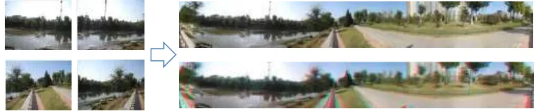
b) Stereo panorama synthesis
After the rough filtering of the pose data we calibrate
images in different directions to a same horizontal plane
with the specific pose data recorded by MTI. Then a stereo
image that has horizontal parallax is synthesized with the
two panoramas carried out by the left and right cameras
(Figure 9).
c) Data management
There are mainly three types of data, image data, pose data
and position data, that need to manage in accord with the
shooting place. To make the following data inquiry and
operation easier we store the transmitted data differently by
using the shooting place, receive time and data type of each
file. We combine each station position with the targets
distance we get from the telescopic range finder and image
pose data so that 3DGIS can automatically find out the
corresponding image to that the users have selected.
Figure 9. A panorama (right upper) and a synthesized stereo (right below)
d) Stereo load and browse
When the data acquisition at each place have finished, the
outdoor terminal will transmit the data to the long-range
on the stereo integrated 3D GIS based on Google Earth and
users could browse the surroundings and other detail
information of the location in the stereo image.
The stereo measurement module is embedded in the image
browse of 3D GIS. Users can begin selecting targets by
easily activating the measurement function of the image
browse dialog (Figure 10 ). Then it will turn to the
measurement interface and allow users to calculate the
position of a specific target on the stereo image as well as
measure the distance between two targets.
Figure 10. Placemarks display and edit in stereo integrated
3DGIS
e) Measurement and result comparison
Using the image data and MTI data we took along the route
of Qinhe River, we carried out the calculation of several
targets that are mainly located on the buildings of the other
side of the river to test the accuracy and practicability of the
measurement module of the stereo integrated 3D GIS.
Figure 11. Targets distribution of the stereo measurement test
By compare the results of the distances and coordinates
measured by GE and the method in 3DGIS we find that the
stereo integrated 3DGIS enable users to browse the overall
image as well as the detail stereo image in the real world. But
the camera calibration error and the shifting between the MTI
position and the cameras both decrease the measurement
accuracy of the stereo integrated 3DGIS. Also the drift of the
MTI data and GPS position data lead a poor quality data of
the camera station location that have been used in the
calculation.
Table 1. Comparison between the distances measured by GE and our method
(� : distance measured by GE, �:distance measured by our method)
Routes � � � � �� %
SA 126.44 118.58 6.22
SB 123.27 116.27 5.68
SC 136.12 123.42 9.33
SD 138.69 129.91 6.33
SE 107.72 98.02 9.00
SF 107.73 98.76 8.33
Table 2. Comparison between the coordinates measured by GE and our method
( , : coordinates measured by GE, , : coordinates measured by our method)
Points � � ∆X m � � ∆Y m
A 4432575.998 4432585.637 9.640 -55798.738 -55791.692 7.046
B 4432577.391 4432586.774 9.384 -55791.898 -55785.710 6.188
C 4432561.951 4432577.668 15.717 -55776.047 -55771.435 4.612
D 4432558.952 4432571.284 12.332 -55760.873 -55761.462 -0.589
E 4432594.317 4432604.862 10.544 -55737.820 -55748.547 -10.727
F 4432595.820 4432605.441 9.621 -55730.724 -55742.197 -11.474
B
A
C
D
E
F
6. CONCLUSION
In terms of the spatial information system data acquisition is
a kind of basic and decisive work. The acquisition of
different types of data could influence the whole method of
the following data processing, management and application.
Though there are many existing 3D GIS, part of which also
declare that they can make measurement, provide limited
measurement accuracy. The method provide in this paper
would achieve accuracy which is the same with that in
Terrestrial Photogrammetry theoretically. But the results
showed in the experiment are not satisfactory for the limited
accuracy of the camera calibration process as well as the MTI
pose data. It could completely achieve the 3DGIS application
requirement in the field of Surveying and mapping.
Except the real-time measurement of fine accuracy the
method also enable users to do a quick data-update,
sometimes on time update, and stereo measurement to aid in
the real time and quick long-distance monitoring of the
important targets when doing emergency rescues. It makes up
the weakness that 3DGIS data is hard to update and express
insufficient detail information of the real world.
Acknowledgements
This study was supported by the Chinese Ministry of Science
and Technology (MOST) through the two research grants (No.
2012BAH27B02 and No. 2012BAK12B02).
REFERANCE
[1] http://www.google.com/earth/explore/products/ (visit
time: 2013.10)
[2] http://roctec.sigm.com.cn/ (visit time: 2013.10)
[3] http://www.mapscene365.com (visit time: 2013.10)
[4] Verbree E., Zlatanova S., and Dijkman S., 2005,
Distance Value Added Panoramic Images as the Base Data
Model for 3DGIS, in Proc. of Panoramic Photogrammetry
Workshop - Berlin Germany, 24-25 Feb. 2005, http:// www2.
informatik.hu-berlin.de/~knauer/ISPRS/panoramicworkshop2
005/Proceedings.htm
[5] Noah S. et al, Photo Tourism: Exploring Photo
Collections in 3D,http://phototour.cs.washington.edu/ (visit
time: 2013.10)
[6] Noah S. et al, 2007, Modeling the World from Internet
Photo Collections, International Journal of Computer Vision
(IJCV).
[7] LI D.R., 2007, On concept and application of digital
measurable images-From 4D production to 5D production [J].
SCIENCE OF SURVEYING AND MAPPING, 32 (4): 5-7.
[8] Luhmann T., Tecklenburg, W., 2004, 3-D Object
Reconstruction from Multiple-Station Panorama Imagery [C].
ISPRS, 34(5/W16).
[9] Fangi G., The Multi-image spherical Panoramas as a
tool for Architectural Survey [C], XXI International CIPA
Symposium, 1-6 October 2007:311~316.
[10] Fangi G., Further developments of the spherical
photogrammetry for cultural heritage [C], 22nd CIPA
Symposium, October 11-15, Kyoto, Japan 2009: 1~6.
[11] Fangi G., 2010, MultiScale MultiReslution Spherical
Photogrammetry with long focal lenses for Architectural
Surveys [C], International Archives of Photogrammetry,
Remote Sensing and Spatial Information Sciences, Vol.
XXXVIII, Part 5 Commission V Symposium, Newcastle
upon Tyne, UK..