GENERATING HIGH-TEMPORAL AND SPATIAL RESOLUTION TIR IMAGE
DATA
M. Herrero-Huertaa,*, S. Lagüelab, S. M. Alfieria and M. Menentia, c
a
Department of Geoscience and Remote Sensing, Delft University of Technology, 2628 CN Delft, The Netherlands – (m.herrerohuerta, s.m.alfieri-1, m.menenti)@tudelft.nl
b
Department of Cartographic and Land Engineering, University of Salamanca, Higher Polytechnic School of Avila, Hornos Caleros 50, 05003 Avila, Spain - [email protected]
c
Remote Sensing and Digital Earth Institute, Chinese Academy of Sciences, Beijing 100101, China- [email protected]
KEY WORDS: Data fusion, Image processing, Remote sensing, Thermal infrared data, Multisensor system, Spectral
Unmixing.
ABSTRACT
Remote sensing imagery to monitor global biophysical dynamics requires the availability of thermal infrared data at high temporal and spatial resolution because of the rapid development of crops during the growing season and the fragmentation of most agricultural landscapes. Conversely, no single sensor meets these combined requirements. Data fusion approaches offer an alternative to exploit observations from multiple sensors, providing data sets with better properties.
A novel spatio-temporal data fusion model based on constrained algorithms denoted as multisensor multiresolution technique (MMT) was developed and applied to generate TIR synthetic image data at both temporal and spatial high resolution. Firstly, an adaptive radiance model is applied based on spectral unmixing analysis of . TIR radiance data at TOA (top of atmosphere) collected by MODIS daily 1-km and Landsat – TIRS 16-day sampled at 30-m resolution are used to generate synthetic daily radiance images at TOA at 30-m spatial resolution. The next step consists of unmixing the 30 m (now lower resolution) images using the information about their pixel land-cover composition from co-registered images at higher spatial resolution. In our case study, TIR synthesized data were unmixed to the Sentinel 2 MSI with 10 m resolution. The constrained unmixing preserves all the available radiometric information of the 30 m images and involves the optimization of the number of land-cover classes and the size of the moving window for spatial unmixing.
Results are still being evaluated, with particular attention for the quality of the data streams required to apply our approach.
1. INTRODUCTION
Thermal infrared (TIR) data is critical to model surface energy balance (Anderson et al., 2011), evapotranspiration and surface moisture (Carlson, 2007) and climate change (Weng, 2009). Biophysical variables and land-cover changes can be retrieved from radiometric data in this spectral region.
Due to technical and financial constraints, no single sensor provides TIR data with both high spatial and temporal resolution (Price, 1994). Temporal characteristic are essential to detect rapid surface changes, decisive in crop-growth monitoring and intra-seasonal ecosystem disturbance (Shabanov et al., 2003). The spatial resolution is compulsory in detailed land-oriented applications to minimize the interpretation errors of the mixed pixels which may represent a mixture of different objects.
Data-fusion models offer synthetic data integrating high spatial and temporal resolution from different sensors. It is a feasible and lost-cost way to enhance the capability of remote sensing to monitor land surface dynamics. Thermal downscaling typically requires preserving the radiometry of original TIR radiance to quantitatively derive radiometry changes caused by phenology (Stathopoulou and Cartalis, 2009). The remote-sensing community has developed two well – documented approaches to do spatial and temporal data fusion. On one hand, the spatial and temporal adaptive reflectance fusion model (STARFM) proposed by Gao et al. (2006), in
which daily Landsat synthetic data were generated from several pairs of Landsat and MODIS images on the same day and one MODIS image on the required day, using a weighted-average approach. On the other hand, existing spatial thermal sharpening techniques rely on disaggregating sensor radiance to higher resolutions usually supported by shorter wavebands, like visible and near-infrared (Dominguez et al., 2011), preserving the spectral configuration of coarse resolution data. These multiresolution image fusion techniques use various deterministic or statistical predictors (Zhukov and Oertel, 1996).
In this research, a new fusion algorithm to predict daily TIR data at 10-m resolution is developed. In the first step, Landsat 8/TIRS (Thermal Infrared Sensor) and MODIS data are blended to obtain daily TIR data at 30-m resolution. After that, the spatial resolution is improved to 10-m, taking advantages of the visible bands of Sentinel 2 MSI, based on a regularized spatial unmixing technique to reduce unmixing error among the mixed pixels. The paper is organized as follows: after this brief introduction, the proposed methodology is described. Next, the results and the discussion are presented. Finally, conclusions are drawn.
2. METHODOLOGY
The proposed approach was designed to generate high temporal and spatial resolution synthetic TIR data based
on MMT algorithm. Figure 1 clarifies the workflow and the data products of our method, explained below.
Fig.1. TIR image result of the proposed methodology.
First of all, TIR data from different sensors at a close acquisition time should be radiometrically calibrated, geometrically rectificated and atmospherically corrected to radiance at sensor to be comparable spatially and temporally (Masek et al, 2005). Nevertheless, factors as acquisition time, bandwidth, orbit parameters, geolocation errors, effective pixel coverage and spectral response function, generate systematic biases among data from different sensors.
The proposed methodology is constituted by different steps. First, an adaptive radiance model is applied based on spectral unmixing analysis from TIR data to model the estimator. Using this approach, the high-temporal revisit frequency of MODIS and the high-spatial resolution of Landsat 8/TIRS are combined to generate a blended image on the required date. TIR radiance data at TOA collected by MODIS daily 1-km and Landsat 8/TIRS 16-day sampled at 30-m resolution are used to generate synthetic daily radiance images at TOA at 30-m spatial resolution on the required date. These synthetic TIR radiances should be corrected for the intra-annual variability, modelled using Fourier series by theoretically calculating the yearly evolution for a range of cases as a function of terrain, land cover and hydrological conditions using Harmonic Analysis of Time Series (HANTS) algorithm (Menenti et al., 1993; Alfieri et al., 2005). The algorithm combines harmonic analysis with curve fitting in iterative steps. At each pixel, the signal is
�(�) =�0+� ���cos(2�����) +��sin(2�����)� ��
�=1 (1)
where nf is the number of frequencies, a0 is the average of
the series and ty the time of observation. The coefficients
a and b are the coefficients of trigonometric components functions at the frequency i.
After this correction, an unsupervised classification is used to identify pixels within the local moving window which are spectrally similar to the central pixel. Next, a weight function is applied that expresses the influence of neighbouring pixels on the central pixel. The weight function is adjusted to the location of the similar pixels and TIR radiance similarity between the fine and coarse resolution data. Finally, an extra-filter is applied to remove poor quality observations and to retain cloud-free pixels.
methodology, applicable to images independently of observed land cover, e.g. rural, urban, desert or forest areas.As an assumption, classes recognizable in the high-spatial resolution data, have the same spectral features in the central and surrounding pixels within the coarse resolution window. This constrained unmixing ensures that the emittance balance for the central pixel is met.. A moving window processing can be applied to reduce the spatial scale of the within-class averaging to the selected window size. A window size of 5*5 pixels in the high resolution image was found to be a good compromise between an acceptable spatial averaging scale of the coarse classes and a sufficient number of coarse pixels for a stable inversion (Zhukov et al., 1999). Then, the contributions of each cluster to the signal that falls within
each Landsat-pixel inside the sliding window is evaluated.. By combining the obtained proportion matrix and class spectra, the algorithm is used to downscale the coarse-resolution Landsat TIR data and retrieve more accurate spectral information for each cluster recognized in the high-resolution data. In order to preserve the available TIR radiometric information of the coarse resolution data, only the excess high spatial frequency components have to be transferred to the low-resolution bands. Finally, fused results at high spatial resolution are obtained by assigning the unmixed spectral information to each class by an inversion of a system of linear mixture equations to the fine resolution clustering map presented in the central pixel of the moving window (Xu et al., 2015).
Fig.2. TIR image result at high spatial resolution
3. EXPERIMENTAL RESULTS
The proposed approach was tested using the data set in the study area, covering 115 km × 100 km South-East of The Netherlands. The predominant wind direction in the Netherlands is southwest, which causes a moderate maritime climate with warm summers and cool winters and typically high humidity. It is a complex area covering many different land cover types, including farmland, forest, bare soil, urban land, wetlands and water as identified by the Netherlands Environmental Assessment Agency (PBL). Cropland patches are small and show distinct temporal patterns based on planting and harvest schedules and local environmental conditions such as soil water content, nutrition and health. In this context, monitoring this crop growth requires high spatial resolution imagery to isolate particular fields and high temporal resolution imagery to track development. In this study, Landsat-8 level 1T geotiff product (Band 10) at 30 m resolution and MODIS level-1 MOD021KM from collection 6 (Band 31) at 1 km resolution was employed. No time correction was applied for the sensor overpass time, choosing the MODIS acquisition time at 10:00 am, same time that Landsat-8 overpasses. This TIR dataset, used to model the estimator, was acquired for both sensors from 14th March 2016 and 20th July 2016. MODIS and Landsat data have to be geometrically pre-processed to the same pixel size and covering the same area and radiometrically calibrated, to ensure the radiance similar pixels. Furthermore, MODIS data was re-projected into Landsat WGS84 projection system by
MODIS Reprojection Tools which use a bilinear resampling method. Moreover, a shared cloud mask was created for both Landsat and MODIS images to remove poor quality pixels, like cloudy areas, from the computation.
The date required for computation was 1st May; accordingly, MODIS image from this date was as well used. To generate the clustering map, Sentinel 2 MSI resolution data on the required date was used. In this step, a 5×5 pixel moving window for the unsupervised classification was chosen.
Fig. 3. Synthetic high resolution TIR image (a) and existing TIR Landsat-8 (b) in radiance values from the same date.
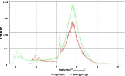
Fig. 4. Histogram of the synthetic high resolution TIR image (in red) and the existing TIR Landsat-8 (in green) in radiance values .
At this point, results are still being evaluated, with particular attention for the required quality of the data streams required to apply our approach.
4. CONCLUSIONS
In conclusion, the proposed methodology advances in the capability for producing remotely sensed TIR data products with both high spatial resolution and frequent coverage from multi-source satellite data. Such a capability is vital to monitor intra-annual biophysical dynamics at the spatial scales most relevant to crop development during the growing season and the fragmentation of most agricultural landscapes.
Special attention was paid to the Annual Temperature Cycle (ATC) model by using HANTS algorithm. To characterize the annual variations of the thermal radiance, HANTS algorithm based on Fourier series was applied. Thereby, thermal radiance changes due to ATC at the coarse temporal resolution can be applied to high temporal resolution pixel.
However, this approach contains a few limitations. The algorithm is not able to predict thermal changes not reflected in the pixels from images, giving uncertainty to the model. Regarding the spatial unmixing algorithm, the clustering map may affect the quality of the fused result, since it accounts only for the classes recognized in the high resolution image. As an advantage, it performs averaging only within the class areas in the window and therefore, the sharpness of the classification map is preserved in the derived image.
Further studies will address to fill up the missing values caused by clouds. Moreover, the extension of the clustering map to multisource data fusion with different spectral bands will be considered.
ACKNOWLEDGMENT
The research is partly funded by “Smart irrigation from soil moisture forecast using satellite and hydro-meteorological modelling (SIM)” from the waterworks 2014 cofounded call. Authors would also like to thank the Government of Spain for funding given through human resources programmes (IJCI-2015-24492 and CAS16/00060).
REFERENCES
Alfieri, S. M., Lorenzi, F. D. and Menenti, M. (2013). Mapping air temperature using time series analysis of LST: the SINTESI approach. Nonlinear Processes in Geophysics, 20(4), 513-527.
Carlson, T. (2007). An overview of the" triangle method" for estimating surface evapotranspiration and soil moisture from satellite imagery. Sensors, 7(8), 1612-1629.
Dominguez, A., Kleissl, J., Luvall, J. C. and Rickman, D. L. (2011). High-resolution urban thermal sharpener (HUTS). Remote Sensing of Environment, 115(7), 1772-1780.
Gao, F., Masek, J., Schwaller, M. and Hall, F. (2006). On the blending of the Landsat and MODIS surface reflectance: Predicting daily Landsat surface reflectance. IEEE Transactions on Geoscience and Remote sensing, 44(8), 2207-2218.
Kustas, W. P., Norman, J. M., Hain, C. R., Mecikalski, J. R., Schultz, L., González-Dugo, M. P., ... and Gao, F. (2011). Mapping daily evapotranspiration at field to continental scales using geostationary and polar orbiting satellite imagery. Hydrology and Earth System Sciences, 15(1), 223.
Masek, J. G., Vermote, E. F., Saleous, N. E., Wolfe, R., Hall, F. G., Huemmrich, F., Gao, F., Kutler, J. and Lim, T. K. “A Landsat surface reflectance data set for North America, 1990–2000,” IEEE Geosci. Remote Sens. Lett., vol. 3, no. 1, pp. 69–72, Jan. 2005.
Menenti M, Azzali S, Verhoef W, van Swol R ,1993. Mapping agroecological zones and time lag in vegetation growth by means of fourier analysis of time series of NDVI images. Adv Space Res 13(5):233–237
Price, J. C. (1994). How unique are spectral signatures?. Remote Sensing of Environment, 49(3), 181-186.
Shabanov, N. V., Wang, Y., Buermann, W., Dong, J., Hoffman, S., Smith, G. R., ... and Myneni, R. B. (2003). Effect of foliage spatial heterogeneity in the MODIS LAI and FPAR algorithm over broadleaf forests. Remote Sensing of Environment, 85(4), 410-423.
Stathopoulou, M., and Cartalis, C. (2009). Downscaling AVHRR land surface temperatures for improved surface urban heat island intensity estimation. Remote Sensing of Environment, 113(12), 2592-2605.
Weng, Q. (2009). Thermal infrared remote sensing for urban climate and environmental studies: Methods, applications, and trends. ISPRS Journal of Photogrammetry and Remote Sensing, 64(4), 335-344.
Xu, Y., Huang, B., Xu, Y., Cao, K., Guo, C. and Meng, D. (2015). Spatial and temporal image fusion via regularized spatial unmixing. IEEE Geoscience and Remote Sensing Letters, 12(6), 1362-1366.
multi-Zhukov, B., Oertel, D., Lanzl, F. and Reinhackel, G. (1999). Unmixing-based multisensor multiresolution image fusion. IEEE Transactions on Geoscience and Remote Sensing, 37(3), 1212-1226.
Zurita-Milla, R., Clevers, J. G. P. W. and Schaepman, M. E., “Unmixingbased Landsat TM and MERIS FR data