CONNECTING THE DOTS TOWARD
URBAN
-PERI
-
URBAN CLIMATE CHANGE RESILIENCE:
THE CASE OF MARIKINA CITY, PHILIPPINES
Romeo B. Santos, Ph.D
, University of the Philippines College of
ESPA/ACCCRN
Connecting the dots toward urban-peri-urban climate change resilience: The case of Marikina City, Philippines
Connecting the dots toward urban
-
peri
-
urb
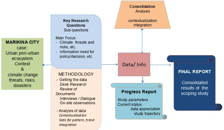
an climate change resilience: The
case of Marikina City, Philippines
Photo cover: Wikimedia.org
Abbreviations and terms used ... 3
Executive Summary ... 5
Background ... 6
Purpose and scope ... 7
Methodology and Key Study Questions ... 8
Work Plan and Study Arrangement ... 10
Review of Documents ... 11
Findings, Analysis and Integration ... 15
1. Urban/peri-urban Ecosystem Profile of Marikina ... 15
2. MAPPING 1: Marikina City Urban/peri-urban Ecosystem and the interaction with climate change related threats, risks, and impacts ... 27
3. MAPPING 2: MARIKINA CITY Urban/peri-urban Ecosystem: Urban management response; the information demand; enablers, barriers or inhibitors; role of research; trans-governance and political economy issues ... 35
Conclusion ... 49
References ... 50
Addendum: Responses to queries and comments ... 54
Acknowledgement ... 61
ESPA/ACCCRN
Connecting the dots toward urban-peri-urban climate change resilience: The case of Marikina City, Philippines
A
BBREVIATIONS AND TERMS USED
ACCCRN - Asian Cities Climate Change Resilience Network ADB - Asian Development Bank
CCA/ CCM - Climate Change Adaptation/ Climate Change Mitigation DRRMC - Disaster Risk Reduction Management Council
DRRMC - Disaster Risk Reduction Management Council GOP - Government of the Philippines
HEA - Hazard Exposure Assessment
Hh - Household
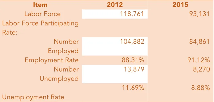
ICT - Information and Communication Technology KI - Key Informant or Key Resource Person LGU - Local Government Unit
Metro Manila - Greater Manila Metropolitan Area or the National Capital Region
MMDA - Metro Manila Development Authority NCR - National Capital Region
DPWH - Department of Public Works and Highways DILG - Department of Interior and Local Government NCCAP - National Climate Change Action Plan 2011-2028
NFSCC - National Framework Strategy on Climate Change 2010-2022 PNP - Philippine National Police
R. A. - Republic Act
Rescue 161 - Emergency Rescue Agency of Marikina
SEARCA - South East Asian Regional Center for Graduate Studies and Research in Agriculture
ESPA/ACCCRN
Connecting the dots toward urban-peri-urban climate change resilience: The case of Marikina City, Philippines
This report presents the results of a scoping study conducted to
determine the factors that influence the achievement of resiliency in the
urban-peri-urban ecosystem of Marikina City in the Philippines.
Commissioned by: Urban Peri-Urban and Ecosystem Working Group, ACCCRN- Mercy Corps / Rockefeller Foundation Copyright: Author
Responsible Romeo B. Santos
Author Romeo Santos and Research Team
The views expressed in this Final Report are the Author’s and do not necessarily reflect those of ACCCRN’s
16 April 2017
Composition of Scoping Study Team:
Leader: Romeo B. Santos, Ph D Arch Eng, Professor Member: Milagros P. Pangan, MA Econ, Research Associate Member: Eric D. Baculi, M CE, Research Associate
ESPA/ACCCRN
Connecting the dots toward urban-peri-urban climate change resilience: The case of Marikina City, Philippines
E
XECUTIVE
S
UMMARY
This paper reports the findings of a Scoping Study that was aimed at understanding the interactions between urban peri-urban ecosystems and climate change risks in the context of Marikina City, Philippines. Marikina is perennially affected by calamities and highly vulnerable to threats of both natural and man-made disasters.
The study was implemented through a small research grant facilitated under the Urban Peri-urban Ecosystem Working Group of the Asian Cities Climate Change Resilience Network (ACCCRN), a community of practice associated with Mercy Corps Indonesia and in collaboration with
Rockefeller Foundation.
The study looked into the case of Marikina, a constituent local government unit, which is one among the 16 cities and 1 municipality comprising the greater metropolitan region of Metro Manila (Metro Manila is also referred to commonly as the National Capital Region or NCR), Philippines. Marikina possesses unique features that merit deeper consideration insofar as urban peri-urban ecosystem is concerned and in view of how climate change impacts the large portion of Manila metropolitan area and the country as a whole.
The research put under spotlight the urban peri-urban ecosystem conditions of the city to enable getting a good grasp of how the interactions between the ecosystem and climate change risks influence the pursuit and achievement of resiliency.
An investigation of the city’s efforts on achieving resilience was done, including looking at the successes and shortcomings, particularly focusing on the threats and risks of climate change seen against the backdrop of its geo-physical and socio-economic characteristics; the diversity of problems the urban peri-urban ecosystem encounters; the responses that were taken; the policies and programs planned and implemented; and the role of information in informing policies and decisions of the city actors; as well as the enablers, barriers, or inhibitors of resilience.
The findings show that the city possesses geographic features that make the achievement of resilience in its urban peri-urban ecosystem a big challenge, particularly in the face of threats, risks and impacts of climate change. However, the data indicates that Marikina appears to have risen above the challenge and in fact achieved some noteworthy accomplishments countering the damaging effects of perennial disasters and the stigma of being a flood-prone, backward municipality of decades ago. It continues to win awards and accolades as an outlier among the neighboring local government units in its effort to counter the negative impacts of climate change and urbanization. This is despite failures or shortcomings in some areas of struggle against
barriers and inhibitors of resilience –some coming from diverse factors that are of political and trans-boundary governance in nature.
ESPA/ACCCRN
Connecting the dots toward urban-peri-urban climate change resilience: The case of Marikina City, Philippines other places that, just the same, contend with the painful experience of managing the urban peri-urban ecosystem over the threats, risks, and impacts of climate change.
B
ACKGROUND
1.
This paper reports the findings of a scoping study that was conducted to understand the interactions between urban/peri-urban ecosystems and climate change risks, in the context of Marikina City, the Philippines. Marikina is perennially affected by calamities and is highly vulnerable to threats from both natural and man-made disasters.2.
The study was implemented through a small research grant facilitated under the Urban/peri-urban Ecosystems Working Group of the Asian Cities Climate Change Resilience Network (ACCCRN), a community of practice associated with Mercy Corps Indonesia and in collaboration with the Rockefeller Foundation.3.
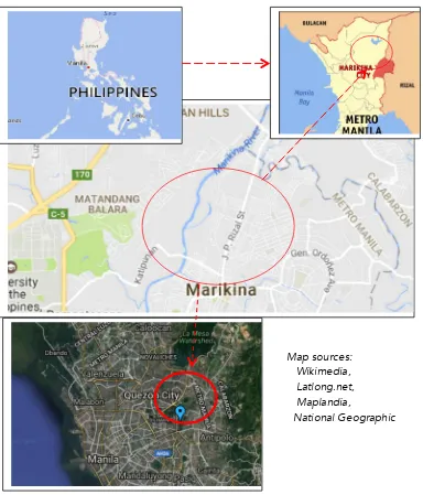
The study looked into the case of Marikina, a constituent Local Government Unit (LGU), which is one of the 16 cities and 1 municipality comprising the greater metropolitan region of Metro Manila (Metro Manila is also referred to commonly as the National Capital Region or NCR), Philippines (Figure 2, Section VI). Marikina possesses unique attributes that merit deeper consideration insofar as its urban/peri-urban ecosystem is concerned, and in view of how climate change impacts a large portion of Manila’s metropolitan area, and the country as a whole.4.
The phenomenon of climate change affecting global ecosystems has rallied a great portion of human society to counter the impacts and threats of disasters arising from aberrant weather conditions. This situation cannot be accentuated more in the case of Marikina City, the geographical and institutional characteristics of which, as well as its strategic response to disasters, make it a good template for understanding the dynamics among urban ecosystems, climate risks, and human efforts for coping, or survival.5.
The author believes that beyond Marikina City’s relatively modest accomplishments and progress in the struggle for achieving resilience, there are noteworthy lessons that can be drawn, which other cities can learn from in their determination to respond to the threats of climate change.6.
The study inventoried the city’s efforts for achieving resilience, including looking at the successes and shortcomings, particularly focusing on the threats and risks of climate change, as seen against the backdrop of its geo-physical and socio-economicESPA/ACCCRN
Connecting the dots toward urban-peri-urban climate change resilience: The case of Marikina City, Philippines
7.
The study puts the urban/peri-urban ecosystem conditions of Marikina under the spotlight to enable it to get a good grasp of how the interactions between the ecosystem and climate change risks influence the achievement of resiliency.8.
The study started on February 13, 2017 and ended on March 31, 2017.P
URPOSE AND SCOPE
9.
The purpose of the study is to understand the interaction between the urban climate risks and the surrounding peri-urban areas and their broader ecosystems, particularly in the context of Marikina City. It sought to determine the types of information that policy and decision makers in the government, civil society and other stakeholders need to mitigate risks as they perform their roles in responding to the impacts of climate change.10.
The TOR (Annex a) states that the lessons gathered from the study will be used to:• Add knowledge to the advocacy platforms practitioners use when building inclusive urban resilience from the government, civil society and private sectors.
• Identify critical trans-boundary governance gaps between cities and their surrounding ecosystems’ administrations, enabling disaster risk reduction and SDGs solutions for cities from threats outside of their governance boundaries.
• Build bridges across Asia between those supplying and those seeking evidence-based information for advocacy and action in building urban resilient agendas.
11.
The study is expected to contribute to the broader ACCCRN research, which seeks to understand the ways in which ecosystem services or dis-services contribute to urban resilience in rapidly urbanizing Asian cities. It may offer lessons on how this can inform and enable policy and decision makers to formulate and implement sounder policies and make better investment decisions.12.
The scope covered the following main aspects (TOR):• Climate-related threats and opportunities that an urbanizing area faces;
• How governance systems respond;
• Who the decision makers are;
• The information decision makers need to address hazards, how information is accessed, and what further information is needed.
13.
Preference (TOR) was given to the following as the objects of the study:• Under-reported secondary cities, in this case – Marikina City, the Philippines;
• Urban/peri-urban ecosystem management successes and failures;
ESPA/ACCCRN
Connecting the dots toward urban-peri-urban climate change resilience: The case of Marikina City, Philippines
14.
The principal user of this study is the Urban/peri-urban Ecosystem Working Group of the ACCCRN. Various sectors, such as the policy and decision makers in urban governance, academia, researchers, and development practitioners, among others, are expected to benefit from the information in this study.M
ETHODOLOGY AND
K
EY
S
TUDY
Q
UESTIONS
15.
The study had a limited time frame and in many respects, paralleled the approach and format common to a rapid investigation type of research.16.
As the study progressed around the key research questions and was supported by spinoff sub-questions during its implementation, there were two-pronged directions along which the methodology was geared towards getting the data and information.17.
First, the mapping of the diverse problems associated with climate-related risks and impacts experienced in both the urbanized areas and the surrounding ecosystems of the locality. It made an inventory of climate-related threats and opportunities; the types, trends and trajectories; the socio-economic and environmental costs – the loss and damage accounts; the actors, drivers and inhibitors; and nature of the responses – the strategies, plans and actions taken by the ‘duty bearers’, aimed at achieving urban resilience, among other things.18.
Second, the mapping of information demands, particularly in relation to urban/peri-urban responses to climate change threats and impacts. It catalogued the type of information or evidence required, used, and/or preferred by policy and decision makers in their quest for better responses. It includes looking into the processes, formats and relevant dimensions, as to their timing and duration - and in correspondence with the types of disasters being addressed; and the barriers and enablers that are identified which are likely to influence sensible actions on the information/evidence, such as trans-boundary governance and political economy factors.ESPA/ACCCRN
Connecting the dots toward urban-peri-urban climate change resilience: The case of Marikina City, Philippines
20.
Some interviews or dialogues were held with KI or key resource persons (local government, NGOs/CSOs, urban planners/managers, duty bearers, local residents, etc.), as timeallowed, which enabled some measure of validation or triangulation of the information. Also, on-site observations were conducted for a rapid mapping of the key concepts underpinning the study and for establishing how the conditions on the ground related to the sources and types of data collected from the literature.
Consolidation
21.
Finally, it consolidated the findings, which involved an analytical process thatcontextualized the knowledge derived from the document reviews, interviews and on-site observations. It identified what is known and not known and then set the findings within the contexts of the policies and practices.
22.
The organized information is now presented as an integrated body of knowledge that provides answers to the key research questions and proof of accomplishment of the two-pronged task of: a) Mapping the climate risks, threats and impacts in interaction with the urban/peri-urban ecosystem, as well as b) mapping the information use and demand that influences the policy and decision making among the city officials.23.
Key Study Questions. Basic to most studies is the use of key research questions - inkeeping with the widely valued principle of research that says, “The key to the right answers (and therefore data) is raising the right questions”. The questions are:
ESPA/ACCCRN
Connecting the dots toward urban-peri-urban climate change resilience: The case of Marikina City, Philippines b. What are the climate-related risks and impacts, both direct and indirect, that the
urban/peri-urban context of the locality experiences?
c. What does the present knowledge/literature say about the nature of information and evidence that matters in the way policy and decision makers address the risks of climate change in Marikina?
d. What lessons on strategies, opportunities, gaps and barriers, enablers and inhibitors, among others, can be drawn that can inform policies and future actions toward achieving climate change resilience in urban/peri-urban areas?
24.
These key study questions served as the basis from which spinoff sub-questions were drawn to guide the following aspects of the research: a) The selection of literature and publications subject to reviews; b) when engaging the resource personnel in interviews and dialogue; c) during site inspections and the gathering of data on the ground.25.
Samples of the spinoff sub-questions derived from the key study questions are shown in the ‘Interview Guide Questions’ appended in Annex b.W
ORK
P
LAN AND
S
TUDY
A
RRANGEMENT
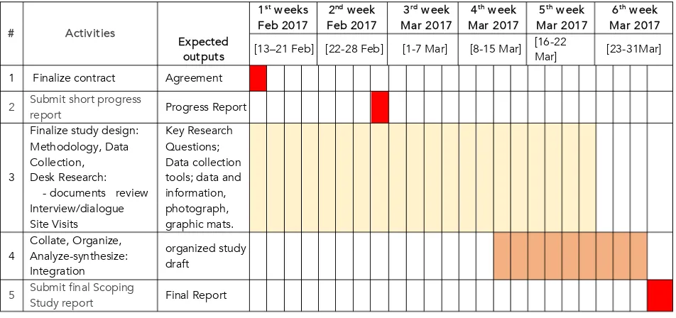
26.
The chart below (Table 1) shows the basic schedule that guided how the study was conducted.Table 1: Work Plan and Schedule # Activities
1 Finalize contract Agreement
2 Submit short progress
report Progress Report
5 Submit final Scoping
ESPA/ACCCRN
Connecting the dots toward urban-peri-urban climate change resilience: The case of Marikina City, Philippines
27.
The study was expected to produce outputs in the form of consolidated publication-type materials representing the results of the study. The outputs are listed below:a. Progress report, which outlines the parameters of the study and gives updates on the status and direction of the research in progress,
b. Final report (this paper), which consolidates the outcomes and provides a more
accomplished and complete research report in compliance with the requirements of the research grant.
28.
The conduct of the study was guided through the Urban/peri-urban Ecosystem Working Group managed by the ACCCRN Regional Manager based in Jakarta.29.
The main author assembled a core group of researchers, who were given specific tasks to ensure timely delivery of the study’s requirements, given the constrained timeframe. Listed below are the members that compose the study team.Team Leader:
Romeo B. Santos, Ph D Arch Eng, Professor
Members:
• Mila P. Pangan, MA Econ, Research Associate
• Eric D. Baculi, M CE, Research Associate
• Mayla L. Antonio, M Arch, Research Associate
• Ana Erika L. Lareza, BS EnvSci, Research Assistant
R
EVIEW OF
D
OCUMENTS
30.
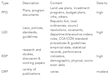
Approach to the Review of Documents. The review of documents adopted a practicalapproach by classifying the documents, based on the nature of their purpose and contents (Table 2). The classification according to type is as follows:
a. Plans and Project Documents (PPD) – those that are directly related and containing information on the strategic plans, the design of initiatives/interventions, profiles and related documents [strategic plan, project work templates such as those excerpted portions showing detailed information requirement – data tracking, table of information to be collected, statistics and figures – particularly dealing with or related to the case of Marikina City]
b. Laws and Standards Documents (LSD) – those that contain laws, policies and standards, and procedures associated with the topic [R.A.s, guidance notes, city council resolutions, standards documents, CCA/CCM standards and guidelines, City Council memos,
ordinances, etc.].
ESPA/ACCCRN
Connecting the dots toward urban-peri-urban climate change resilience: The case of Marikina City, Philippines information or statistical figures that have a weighty bearing on the search for data, particularly on Marikina City.
d. Other Records and Publications (ORP) - ancillary documents that are obtained through desk research, news articles about Marikina City and related stuff, website searches and contributions from other sources, which provided a wider background and a relevant perspective on the topic.
Type Description Content Data to SST
PPD Plans, program
publications varies moderate
Table 2: Types of documents and corresponding value of contents relative to the Scoping Study’s Targets
31.
The classification was used as a benchmark for assessing the contents of the documents, inview of their significance in accomplishing the objectives of the study. Particular attention was given to the level of data provided for or available in the documents, which can satisfy the study’s requirements, or the targeted data and information of the Scoping Study. It also made consideration of the potential by which the documents can provide leads toward identifying further sources for more in-depth data gathering.
32.
Reflections on the data trajectory. Using the documents classification as the basis, the initialoutcome of the documents review included the identification and selection of specific documents and publications that have the potential to provide the data and information needed by the study:
a. Plans and Project Documents (PPD)
1. Ecological Profile –EP (2016), Marikina City
ESPA/ACCCRN
Connecting the dots toward urban-peri-urban climate change resilience: The case of Marikina City, Philippines 3. Comprehensive Development Plan –CDP (2016), Marikina CIty
4. Executive and Legislative Agenda –ELA (2016), Marikina City 5. Budget. Plan, Marikina City
6. Annual Investment Plan –AIP (2016 -2017), Marikina City 7. Other documents
b. Laws and Standards Documents (LSD) –
The legal and standards documents are composed of various laws, international conventions on climate change, rules and standards, and international frameworks for measuring resilience. Some documents selected for reading include:
1. GCI, ISO, WCCD - ISO 37120 – Smart City Standard, Sustainable Development of Communities
2. Grosvenor - Resilient Cities
3. UN-Habitat - City Resilience Profiling Tool
4. Aecom, IBM, UNISDR - Disaster Resilience Scorecard for Cities 5. Cutter et al. – Disaster Resilience Indicators
6. NIST - Community Resilience Planning Guide 7. World Bank - City Strength
8. ISO 37120 2014. ‘Sustainable development of communities: Indicators for city services & quality of life’, ISO, Geneva.
9. OECD 2014. ‘Guidelines for resilience systems analysis, How to analyze risk and build a roadmap to resilience’, OECD Publishing.
10.United Nations University 2013. ‘Indicators of Resilience in Socio-ecological Production Landscapes (SEPLs)’, UNU-IAS, Yokohama.
c. Research/ Discussion Papers (RDP)
The research/discussion papers are research-based publications that contain a more empirically organized body of data, statistical figures, and records about climate change adaptation/mitigation interventions, hazard and vulnerability studies, case work on
environment research and the like. Some of the publications that were reviewed are listed below:
1. ADB 2016. ‘Climate Change Vulnerability Assessment, Lower Marikina River Basin’ 2. ARUP 2016. ‘City resilience index, understanding and measuring city resilience’. 3. ARUP 2016. Inside the CRI: Reference Guide.
ESPA/ACCCRN
Connecting the dots toward urban-peri-urban climate change resilience: The case of Marikina City, Philippines 5. Cities Alliance 2009. ‘Updated City Development Strategy Report for Marikina City:
City Development Strategies in the Philippines: An Enabling Platform for Good Governance and Improving Service Delivery (P098173)’, Cities Alliance Report. 6. City Resilience Index2014. Research Report, Volume 1, Desk Study.
7. Cuevas, S. 2015. ‘Linkages among the challenges in mainstreaming climate change adaptation into local land use planning’, Transactions on Ecology and The
Environment, Vol 194, WIT Press, University of Queensland, Australia. 8. De Leon, E. 2016. ‘Barriers in scaled climate change adaptation policy in the
Philippines’, UN Peace and Progress, Vol 3(1), pp 32-34.
9. Salceda, J. 2012. ‘Agriculture and Development Notes on Climate Change Adaptation,Vol 2. No. 1.
10.Ove Arup & Partners International Limited 2014. ‘City Resilience Index’, Research Report, Urban Measurement Report, Volume 3.
11.Tyler, S. et. al. 2014.‘Developing Indicators of Urban Climate Resilience’, ISET, Colorado.
d. Other Records and Publications (ORP)
The ‘other records’ documents include a wide variety of publications ancillary to the topic. These include articles in newspapers and similar media. A number of these documents were sourced from on-line sites, including:
1. Bonquin, C.2015. ‘Which regions, provinces, cities are the Philippines’ richest?’, ABS-CBN, ABS-CBN News.
2. Cuevas, S. C. 2015, ‘Linkages among the challenges in mainstreaming climate change adaptation into local land use planning’, University of Queensland, Australia, from www.witpress.com, ISSN 1743-3541 (on-line) WIT Transactions on Ecology and The Environment, Vol 194,© 2015 WIT Press
3. De Leon, M. 2011. ‘Philippine education ranked poor’, Business Mirror. Retrieved July 13, 2012, from ABS-CBN News:
http://www.abs-cbnnews.com/business/06/14/11/philippine-education-ranked-poor
4. Desiderio, L. 2013. ‘CDO tops list of Phl's most competitive cities’, Business, News, The Philippine Star.
5. ADB 2008. ‘Country Water Action: Flood-Ready Marikina City Project’, Result/Case Study.
6. Other documents
ESPA/ACCCRN
Connecting the dots toward urban-peri-urban climate change resilience: The case of Marikina City, Philippines references to the main sources from where the data originated, provided some leads for the author to follow through and make a wider range of data collection sources.
F
INDINGS
,
A
NALYSIS AND
I
NTEGRATION
34.
The following presentation shows the wide range of data and information that were gathered, organized, analyzed and contextualized to form the body of knowledge drawn from the study of the urban/peri-urban ecosystem of Marikina City and its interaction with climate change threats, risks and impacts.1. Urban/peri-urban Ecosystem Profile of Marikina
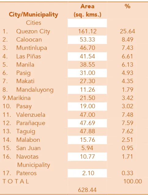
35.
Geographical / Topographical Features. Marikina is a city lying in a valley between ameandering river and the rolling mountains of the Sierra Madre, a prominent mountain range covering a large area of Luzon Island in the Philippines. The geographical or
topographical attributes of Marikina may appear perfect for photography buffs, yet a true headache for urban managers during bad weather seasons.
36.
Marikina City is only 3.42% of the total land area of Metro Manila. Table 3 illustrates a comparison among the 16 constituent cities and 1 municipality comprising the national capital region, in terms of land area and percentage coverage.ESPA/ACCCRN
Connecting the dots toward urban-peri-urban climate change resilience: The case of Marikina City, Philippines Figure 2: Composite Maps of Marikina City
Map sources: Wikimedia, Latlong.net, Maplandia,
ESPA/ACCCRN
Connecting the dots toward urban-peri-urban climate change resilience: The case of Marikina City, Philippines
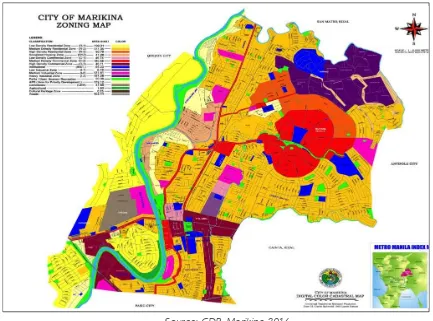
Source: CDP, Marikina 2016
Figure 3: Zoning Map, Marikina City 2013-2020
38.
Figure 3 shows the zoning characteristics of the city in relation to its geography. Unevenly located are low, medium and high density residential areas along the Marikina River’s banks, which are perennially and heavily inundated during the wet season. The Philippines has only 2 distinct seasons –the wet (from May to October) and dry (from November to April).ESPA/ACCCRN
Connecting the dots toward urban-peri-urban climate change resilience: The case of Marikina City, Philippines
Source: Ecological Profile, Marikina 2016
ESPA/ACCCRN
Connecting the dots toward urban-peri-urban climate change resilience: The case of Marikina City, Philippines
City/Municipality
Table 3: Land Area of Component Cities and Municipality of Metro Manila
39.
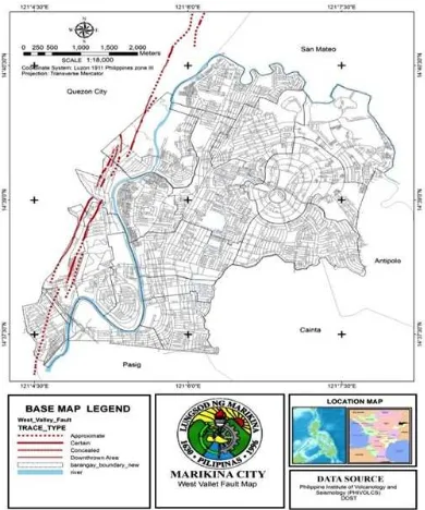
Adding to the precarious geological conditions is the presence of a seismic fault (Figure 4, West Valley Fault), a long portion of which runs parallel to the Marikina River. This fault renders the city very vulnerable to earthquakes (Ecological Profile, Marikina 2016).40.
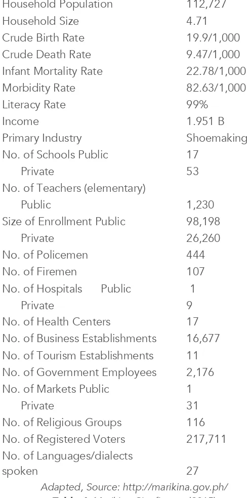
Demographic and Socio-economic Profile. The population of Marikina stands at 531,128residents, comprising a total of 122,727 households (Table 4 and Table 5) in 2015 (108, 958 households in 2012). The density is 22,949 per hectare in 2012 (23, 878 in 2015). It is remarkable that a 99% literacy rate is enjoyed by Marikina residents. The data in Table 6 shows disaggregated figures based on sex for the population 10 years and older.
Land Area 2,314.37 hectares
No. of Districts 2
No. of Barangays (villages) 16 Population Density 22,949
ESPA/ACCCRN
Connecting the dots toward urban-peri-urban climate change resilience: The case of Marikina City, Philippines Household Population 112,727
Household Size 4.71
Crude Birth Rate 19.9/1,000 Crude Death Rate 9.47/1,000 Infant Mortality Rate 22.78/1,000
Morbidity Rate 82.63/1,000
Literacy Rate 99%
Income 1.951 B
Primary Industry Shoemaking
No. of Schools Public 17
Private 53
No. of Teachers (elementary)
Public 1,230
Size of Enrollment Public 98,198
Private 26,260
No. of Policemen 444
No. of Firemen 107
No. of Hospitals Public 1
Private 9
No. of Health Centers 17 No. of Business Establishments 16,677 No. of Tourism Establishments 11 No. of Government Employees 2,176 No. of Markets Public 1
Private 31
No. of Religious Groups 116 No. of Registered Voters 217,711 No. of Languages/dialects
spoken 27
Adapted, Source: http://marikina.gov.ph/
ESPA/ACCCRN
Connecting the dots toward urban-peri-urban climate change resilience: The case of Marikina City, Philippines
Barangay
Table 5: Number of Population, Hh, Density, Per Barangay, Marikina City, 2012
Marital Status
Household Population 10 Years Old and Over Male Female
Divorced/Separated 1,690 4,514 6,204 2.90
Common-law/Live-in 12,646 12,954 25,600 11.95
Unknown 113 176 289 0.13
TOTAL 104,427 109,726 214,153 100.00 Sources: CBMS, 2015
Table 6: Household Population 10 Years Old And Over By Sex and Marital Status Marikina City, 2015
ESPA/ACCCRN
Connecting the dots toward urban-peri-urban climate change resilience: The case of Marikina City, Philippines elements are likely to play a big role in any city’s socio-cultural fabric, and bear on the level of social harmony and tolerance affecting the urban peace and order environment. Record-wise, however, there is no particular concern arising from these aspects that deserves serious attention in Marikina.
Item 2012 2015
Labor Force 118,761 93,131
Labor Force Participating Rate:
Number Employed
104,882 84,861
Employment Rate 88.31% 91.12%
Number Unemployed
13,879 8,270
Unemployment Rate
11.69% 8.88%
Source: CBMS data, 2012 & 2015
Table 7: Labor Force and Employment, 2012–2015
42.
Table 7 presents the city’s figures on employment in 2015 – showing it had a total working population of 93,131, of which 84,861 are employed (91.12%), and the remaining 8, 270 (8.79%) were not.43.
Marikina is popularly known as the shoe capital of the Philippines and has taken pride in this indigenously developed source of livelihood. The shoe manufacturing trade shows no big signs of decline and is still a source of esteem among the local populace. The Guinness Book of World Records has certified that the world's largest pair of shoes are now currently on display at the Riverbanks Center, Marikina – a monument to the trade - shown in Figure 5.ESPA/ACCCRN
Connecting the dots toward urban-peri-urban climate change resilience: The case of Marikina City, Philippines
Source: Ecological Profile, Marikina 2015
Figure 5: World’s largest pair of shoes, Marikina City
Source: Business Permit and Licensing Office, 2015
Table 8: Type and Frequency of Manufacturing Firms, 2011-2015
45.
The Marikina Community Based Monitoring System (CBMS) census conducted in 2015 found that 14% of the population surveyed was poor, 24% were in the low-income class, 38% were lower-middle and 22% belongs to the middle-middle class. This means that a largeproportion of the total population of the city are low income families (Table 9).
ESPA/ACCCRN
Connecting the dots toward urban-peri-urban climate change resilience: The case of Marikina City, Philippines
Income Class Monthly family income for a size of five (5) # of HHs %
Poor 9,140 7,468 14
Low (but not poor) 9,140 to 18,280 13,021 24
Lower-middle 18,280 to 36,560 20,499 38
Middle-middle 36,560 to 91,400 11,990 22
Upper-middle 91,400 to 137,100 727 1
Upper (but not rich) 137,100 to 182,800 216 0.399
Rich 182,800 above 219 0.405
TOTAL 54,140 100
Source: CBMS data, 2012& 2015
Table 9: Income Distribution
46.
Disaster risk reduction and emergency response; reflections on urban management.Marikina City is currently known in the country as one of the “best local government units in the Philippines”. It was hailed as a city with “a professional and efficient bureaucracy, a clean environment, booming economy, and a disciplined constituency, among others” (Cities Alliance, 2009).
47.
But in the past, Marikina was once a third class municipality well-known for flooding, a dumping ground for murder victims and even dubbed as the “rape capital of thePhilippines”. It was just a few decades ago that the peace and order situation was at its worst, and the place was still an underdeveloped suburb east of Manila.
48.
An editorial writer of a popular broadsheet noted that it was only ten years ago when the city was notorious for having a high record of rapes among young girls and women. When the Asian Institute of Management gave the town of Marikina an award as the "most responsive local government unit" in 2002, he quipped “It deserves it. Marikina has been one of the most amazing things to happen in a long time” (Quiros 2002).ESPA/ACCCRN
Connecting the dots toward urban-peri-urban climate change resilience: The case of Marikina City, Philippines balance between urbanization and environmental management is a formidable development issue that the city has to deal with” (Cities Alliance 2009).
50.
Let us look at one example where Marikina City takes prides in achieving success. Figure 4 is an organizational chart for the Disaster Risk Reduction and Management Council of Marikina in which Rescue 161, an attached agency unique to the city, is shown closely linked to and directly under the office of the city mayor. Rescue 161 is a highly mobile emergency organization that maintains a well-trained line up of capable personnel and advanced equipment to respond to calls for emergency assistance.ESPA/ACCCRN
Connecting the dots toward urban-peri-urban climate change resilience: The case of Marikina City, Philippines
51.
Remarkably, Rescue 161 has an outstanding and sustained record of a 100% response rate, within a 5-minute period from the time an emergency of any type is reported. This is quite impressive and the Executive Director, Dr. Jenny Fernando attributes this feat to acombination of its track record and long experience with emergencies, highly trained and committed personnel, and strong support from a harmonized and dedicated local
bureaucracy, among others.
Source: CDP, Marikina 2013-2020
Figure 7: Marikina Strategy Map
52.
The Marikina City 2020 Strategy Map shown in Figure 7 above illustrates the city’s strong emphasis on removing the stigma of the city as a flood-prone area. This is set under the broader objective of achieving a safe environment for all, which is also linked with the core values aspired to by the city.ESPA/ACCCRN
Connecting the dots toward urban-peri-urban climate change resilience: The case of Marikina City, Philippines functionality”, which among others, are reflective of the progress that the city has achieved to a remarkable extent.
54.
The news coming out from various media sources lately, as well as anecdotes generated by local residents and outside observers about Marikina, are generally expressed in a positive light. The lead researcher, in particular, has personally experienced walking the streets of practically all the villages of the city in the mid-2000s for a community-oriented, house-to-house mission and was amazed at that only a few residents expressed negative comments about the city and its officials, both from the ranks of the (former) informal settlers and those well-to-do householders of the posh subdivisions.2. MAPPING 1: Marikina City Urban/peri-urban Ecosystem and the
interaction with climate change related threats, risks, and impacts
55.
Marikina, a multi-hazard environment. There are (11) types of hazards faced by Marikina:Flooding, landslides, drought, and liquefaction and their combinations. Figure 8 shows the climate change vulnerability assessment conducted through ADB (2013). It underscores the pervasiveness of flooding, with the combined effects of erosion, and intermittent liquefaction.
Source: ADB TA 8493 Climate Change Vulnerability Assessment, Lower Marikina River Basin, Marikina City, 2013-2017
https://www.adb.org/projects/46441-001/main#project-pds
ESPA/ACCCRN
Connecting the dots toward urban-peri-urban climate change resilience: The case of Marikina City, Philippines
56.
Based on the ADB study (TA 8493, ADB 2013), the assets exposed to hazards can besummarized in the table (Table 10) below. This shows that 66% of the assets are exposed to deep flooding hazards and all the assets are exposed to multiple hazards. As for the roads, Marikina City has a total of 437 km of roads. Of this length, 3% is exposed to flooding and 89% exposed to multiple hazards.
Number of Assets Exposed to Hazards
Assets Total Exposed to deep flooding Exposed to Multi Hazards
Churches 9 9 9
Source: ADB TA 8493 Climate Change Vulnerability Assessment, Lower Marikina River Basin, Marikina City, 2013-2017
Table 10: Marikina City - Assets exposed to flooding and multiple hazards
57.
Marikina’s flood-freak location. The geographical location of Marikina City virtually makes it a catch basin to 5 other populated cities and towns: Quezon City to the west, and Tanay, Montalban, San Mateo and Antipolo City, all in the Province of Rizal, which lie on the hilly and mountainous parts of its northeastern and eastern boundaries (see Marikina’s response to this problem with trans-boundary governance implications at Section IX.III, #74). Due to this feature, it is identified as the Lower Marikina River Basin (Figure 7), where the runoffs during rainy seasons and torrential typhoons converge heavily, while the water finds its way towards Manila Bay or Laguna de Bay through the Marikina River and then the Pasig River and San Juan River systems.58.
Figure 9 below illustrates the difficulty of flushing excess water runoff towards the two water reservoirs. The Pasig River and San Juan River are 2 river systems that could have made the drainage work effectively, but their long length and circuitous nature, plus theESPA/ACCCRN
Connecting the dots toward urban-peri-urban climate change resilience: The case of Marikina City, Philippines
Source: Sato, T. & Nakasu, T. 2011. “2009 Typhoon Ondoy Flood Disasters in Metro Manila”, Natural Disaster Research Report of the National Research Institute for Earth Science and Disaster Prevention, No. 45
Figure 9: Geographical location of Marikina City
59.
The Manggahan Floodway that conveys the runoff towards Laguna de Bay, a fresh water lake South of Manila, is another option, yet similarly, the heavily silted condition of the lake, due to the excessive presence of fish pens, poses a real problem.60.
The ADB study’s multi-hazard vulnerability index categorizes the barangays of Barangka, Concepcion Dos, Fortune, Marikina Heights, Nangka and Parang as moderate (0.51-0.58), while the rest are classified with high vulnerability (0.61- 0.71). These vulnerability results are also due to the close proximity of the barangays to the river (ADB 2013).61.
Marikina’s sixteen (16) barangays experience severe flooding (Table 5; Figure 10a & b). The population exposure results show that 85% of the total area of the city is exposed to various flood depths, 58% of which is high flooding (>) 1.5 to 3 meters and above. This corresponds to more than half or 58% of the population (2010). There are 11 barangays with more than 50% of their areas deeply flooded, namely Concepcion Dos, IVC, Jesus Dela Pena ,ESPA/ACCCRN
Connecting the dots toward urban-peri-urban climate change resilience: The case of Marikina City, Philippines
Source: ADB TA 8493 Climate Change Vulnerability Assessment, Lower Marikina River Basin, Marikina City
Figure 10a: Flooding and Population
Source: Rescue 161, Marikina City
Figure 10b: Marikina City Hall during a flood
61. Potential Impacts. The potential impacts, identified based on climate change scenarios, are
rainfall changes, a temperature increase, and drought (or El Nino), which are relevant to the context of Marikina City and are seen to affect development sectors such as transportation, water, and health (ADB 2013).
ESPA/ACCCRN
Connecting the dots toward urban-peri-urban climate change resilience: The case of Marikina City, Philippines 63. The critical sectors in Marikina that are vulnerable and prone to climate change impacts (flood
or drought), are described below. These were assessed using various indicators such as sensitivity, exposure, and the adaptive capacity indices, as a result of a study commissioned by the ADB, as shown in Figure 10a & b (ADB 2013).
64. Health Sector. The impact on health includes: (1) Diarrhea or diarrheal diseases (specifically
cholera and typhoid fever), (2) dengue fever or dengue hemorrhagic fever, and (3)
leptospirosis. Malaria is not included in the scoping because it is non-endemic in Marikina. Barangays (list of barangays, Table 5) with a moderate diarrhea and dengue vulnerability index are Concepcion Uno, Marikina Heights (Concepcion) and Tumana, while the rest of the 13 barangays have a low diarrhea vulnerability. The only barangay with a moderate
leptospirosis vulnerability index is Concepcion Uno, and all the other barangays fall into the low category (ADB 2013).
65. Water Resource Sector. Some indicators of impacts can be noted, such as the fluctuations in
streamflow storage over the years and the proportion of domestic water shortage through the barangay’s water consumption data versus water demand. Two barangays, namely - Marikina Heights and JVC, fall into the moderate category of drought vulnerability. The other
barangays are considered to be it the low category of vulnerability to drought, however they are still considered for the improvement of water resource’s security (ADB 2013).
66. All barangays of Marikina city fall into the moderate category of vulnerability to flooding, in relation to water resources. One notable characteristic is the proportion of settlements
affected by floods, and the population living near rivers and creeks, which contributes greatly to the high level rating of exposure.
67. Transport Sector. The indices for vulnerability to flooding of the barangays are all classified
as being high (0.69 – 0.79), and very high (0.81) for Malanday and Tumana. Vulnerability to climate change induced landslides, relative to transport-roads, is classified as high (0.61-0.68) in barangays Barangka, Fortune, Tañong and Tumana, moderate in barangays JVC, Jesus dela Pena, Malanday and Marikina Heights and low for the rest of the barangays. While the sensitivity, exposure and adaptive capacity indicators classified all the barangays in the high vulnerability category for liquefaction, except for Barangka, Concepcion Dos, Fortune, Marikina Heights and Parang, which were categorized as low (0.25 – 0.34) (ADB 2013).
68. Socio-economic and environmental costs. One disaster event that left a remarkable imprint
in the history of Marikina was the flooding disaster brought about by tropical storm Ketsana (Ondoy, locally) that struck major parts of Luzon Island on September 9, 2009. The storm left 14 of the 16 barangays of Marikina City under water.
ESPA/ACCCRN
Connecting the dots toward urban-peri-urban climate change resilience: The case of Marikina City, Philippines various forms of damage, creating a heavy burden on the city’s agencies and bureaus, as the people who were supposed to run the services were themselves undergoing a calamity.
70. There were 33 casualties among Marikina residents who were identified among the 68 dead bodies recovered from various points in the city. There were 18, 642 houses damaged, around 1,500 residents fled to places outside the city, and 35, 428 families (176,008 persons) were forced to evacuate to different evacuation centers of the city at the height of the floods (Figure 11).
Source: Rescue 161, Marikina
Figure 11: An evacuation center scene, Marikina City, 2009
71. An outbreak of leptospirosis was also recorded during this period of calamity. There were 78 confirmed cases, 405 suspected cases, and 35 deaths.
72. Actors and drivers of resilience. The city officials who were interviewed cited the
harmonious and cooperative culture that currently exists among the different agencies and functionaries of the local government within Marikina, which somehow is instrumental in achieving some measure of the resilience that the city is now enjoying.
73. Some attributed the development of this ‘culture’ to the long history and experience of disasters that the Marikina communities have gone through. That was coupled with some kind of providence in having excellent leadership from the early city executives, who
ESPA/ACCCRN
Connecting the dots toward urban-peri-urban climate change resilience: The case of Marikina City, Philippines 74. Some people cited the evident advantage possessed by Marikina City over other LGUs in the
country and this is seen in the way various agencies and offices of the city, such as the Executive, City Council, Planning, DRRMO, Health, CPDO, CEMO, and Rescue 161 among others, are demonstrating qualities of “effective interconnectivity” and “a culture of
adaptability, cohesiveness and functionality”. The level of professionalism among the LGU officials and personnel is also cited as a demonstrable attribute, in the way city services are delivered and how the local government offices connect with the grass-roots communities.
75. The capable state actors, duty bearers, or champions that are interspersed within the various local government agencies in Marikina may not need to be specifically named on a personal basis, but the results show that both urban services are delivered, and the urban ecosystem is managed, with efficiency and effectiveness, which is some sort of affirmation that they do indeed exist (Figure 14).
ESPA/ACCCRN
Connecting the dots toward urban-peri-urban climate change resilience: The case of Marikina City, Philippines
Source: Rescue 161, Marikina 2017
Figure 12: Rescue 161 personnel with a record of 100% response rate within a 5- minute duration upon receipt of call for help.
77. The local community’s grass-root organizations, represented by local NGOs, CSOs, community groups, neighborhood and homeowners associations, and similar village level institutions are functioning as either actors, or enablers in their own sphere of influence, to make possible the effective implementation of various city initiatives benefiting the citizenry.
78. The strong cooperation among the various sectors is very much evident in the area of social services, particularly in housing. Marikina is known for virtually eliminating squatting and the claim that there are no squatters in the city can be strongly tenable (Figure 13), or arguable.
79. Visits to (previous) informal settlement areas show that at present the places are well-organized neighborhoods, with well-planned roads and alleyways, utilities, and other necessary services for well-functioning, normal communities - despite signs of poor quality construction still being visible on evolving individual houses that need improvement on a household level (Figure 13
WITH EXTERNAL ASSISTANCE AND A CITY
WITH AN ACTIVE PREPAREDNESS PROGRAM
ESPA/ACCCRN
Connecting the dots toward urban-peri-urban climate change resilience: The case of Marikina City, Philippines
Source: Rescue 161, Marikina
Figure 13: The ‘no-squatter in Marikina’ initiative
3. MAPPING 2: MARIKINA CITY Urban/peri-urban Ecosystem:
Urban management response; the information demand; enablers,
barriers or inhibitors; role of research; trans-governance and
political economy issues
80. Marikina City government’s response to climate change threats, risks, and impacts.
ESPA/ACCCRN
Connecting the dots toward urban-peri-urban climate change resilience: The case of Marikina City, Philippines 81. Marikina, as has been noted, is very prone to flooding because it is nestled in a lush valley
bounded by mountain ranges and sliced by a river. Working under these conditions, the former mayor, Mayor Bayani F. Fernando (1992-2001) reactivated the Marikina Disaster Coordinating Council when he entered office in 1992. He is known to have spearheaded the transformation of the city towards change. He followed through on bills to strengthen campaigns on climate change as a congressman in the House of Representatives after his stint as a mayor.
82. Under Fernando’s administration, disaster scenarios were addressed at three (3) levels, namely: Pre-disaster, disaster and post-disaster, although more emphasis was given to the preparedness aspect of the program. Since 2001, Marikina has been transformed from a 4th class municipality to a Philippines model city, according to numerous citations and
awards received by the city. The present mayor, Mayor Marcelino Teodoro, is credited with have revitalized the program through the Marikina City Disaster Risk Reduction and Management Council (Figure 6).
83. The study team’s interactions with a number of city officers and personnel, as well as local residents, show that Marikina’s constituents take pride in saying that the city has “very responsive and proactive DRRM programs” (Rescue 161, 2015), which are recognized locally and internationally, as evidenced by the numerous awards received (Annex d).
84. Remarkably, among the 7 priority sectors as identified by the National Framework Strategy on Climate Change 2010-2022 (NFSCC), Marikina has been noted to be strongest for its human security, which includes DRRM.
85. Based on the researchers’ review of Marikina’s Local Investment Development Plan 2016-2018, as well as various documents provided by the different departments of the
municipality, strategies and programs are grouped according to the 7 strategic priorities of the NFSCC.
86. The 7 priority areas under the NFSCC are: a) Food security
b) Water sufficiency
c) Ecological and environmental stability d) Human security
ESPA/ACCCRN
Connecting the dots toward urban-peri-urban climate change resilience: The case of Marikina City, Philippines
87. Food Security. Marikina is non-agricultural, thus, heavy programs for large scale
agricultural food and commodity production do not find emphasis in the current plans of action. However, the programs for food security include the reforestation of public lands, promotion of urban agro-forestry, and urban agriculture in urban neighborhoods.
88. Human Security. Marikina City has a number of programs and projects to address the
issue of human security. The city’s strategies are classified into four, as adopted from the NCCP, namely, integration of the CC-DRRM in local plans, increasing local and community capacities for CCA-DRRM, health emergency response, preparedness and post-disaster risks in place, development of a long-term plan for the adaptation of highly CC vulnerable population and climate refugees, and the development and implementation of knowledge management on CC and disaster risks.
89. Water Security. Major projects included in this priority area are flood mitigation and
control. Marikina continuously implements programs and projects that will minimize flooding in case of extreme weather conditions. Among these are the implementation of effective flood control gates, the completion of a major flood control drainage system, construction of road dikes/retaining walls/rip-rap, the dredging of the Marikina River and the establishment of pumping stations. More projects are also auctioned for de-clogging, dredging, pumping stations, slope protection and roadside improvements.
90. Marikina has installed wastewater treatment facilities in strategic areas and improved the sewage disposal system in order to maintain the water quality. Scheduled emptying of septic tanks, which are free to customers not connected to the network, is made available to minimize the contamination of ground water. Continuous monitoring and cleaning of creeks is being done to improve the water quality. Water conservation is being
encouraged through the installation of rainwater harvesting systems in all public schools.
91. Ecological and Environmental Stability. The projects under this scheme include tree
planting, an urban greening program, landscaping, the development of parks and a bikeway network, among others. According to Marikina City’s motivation advocacy, the bicycle program is designed to decongest the traffic on the roads, increase mobility and provide low income people with a mode of transport that will allow them to have a healthier lifestyle.
92. In 2005 the project earned Marikina a Galing Pook Award as an Outstanding Program in Local Governance and it was cited by the World Bank as one of the 4 Model Cities in the world during the World Bank Annual Bank Conference on Development Economics in June 2006 in Tokyo.
93. Sustainable Energy. The city is in the process of developing strategies in support of
ESPA/ACCCRN
Connecting the dots toward urban-peri-urban climate change resilience: The case of Marikina City, Philippines building maintenance program to improve energy efficiency, use of more energy efficient street lights) and the development of renewable energy for the city buildings (e.g.,
establishment of solar panels, installation of windmills, bio-gas in all government buildings and infrastructure).
94. Climate Smart Industries and Services. The solid waste management system of Marikina
is efficient and effective, resulting in reduced amounts of solid waste that goes to the landfill, the recovery of recyclable materials, and providing employment and generating income. The existing facilities for waste management are the material recovery facility for dry waste, a composting facility, and a recycling and processing facility using styro and sando bags.
95. Under the priority area, another Gawad Pook Award for Marikina was received through a project named ‘’Eco-savers Program’’. This program encourages students in public elementary schools to bring recyclables to school; the students earn points that are
recorded in their eco-savers club passbooks, which can then be exchanged for groceries or school supplies.
96. The Eco-savers Program is an ingenious way of involving and motivating young people to have a stake in the care for the environment, raising their awareness of it and providing them with opportunities for actual participation in the city initiatives
97. Information demand: Types of information or evidence required by policy and
decision makers; role of research. Marikina City appears to demonstrate a higher level of
interconnectivity among its various department and offices, particularly in the areas of emergency response and urban management services (traffic, housing, cleanliness, peace and order, etc.) compared to its neighboring cities. In this regard, the use of information among the various functionaries of the local government must be playing a significant role.
98. Basing on the data gathered from the documents’ review, interviews with city officers and observations on-site by the researchers, the ‘interconnectivity’’ may not be in the technical aspects alone (use of technology, relays and substations strategy, and the like), but it also has a softer-side dimension, which can be deduced from the learning adaptability,
cohesiveness and functionality ‘culture’ that is claimed to exist among the Marikina communities.
ESPA/ACCCRN
Connecting the dots toward urban-peri-urban climate change resilience: The case of Marikina City, Philippines 100. The transmission of information (department to department, city office to communities,
etc.) is noted to be relatively highly efficient. This was tested by the study team’s experiences when filing requests for audience with the city officers and community leaders, as well as for copies of official documents. The warm response and ease of dealing with the various offices and personnel, the quick receipt of things requested, and the prompt setting of appointments with resource persons were surprisingly remarkable – if the experiences the team had with other LGUs in previous and different study projects were to be compared with.
101. The way how the transmission of information worked in a particular city agency was demonstrated by the visits (3x) made by the study team to the Rescue 161 command center. This is a secure place, where many TV screens, connected to various CCTV locations, relay real-time conditions in the urban ecosystem (roads, rivers, nodes, parks and public spaces, etc.) that are monitored and acted upon if required. A number of Rescue 161 relay substations, with a complete range of emergency response logistics, are located and distributed within a 5-minute response distance from any point in the city, ready to act upon any emergency information received (Figure 14).
102. The command center houses the large screen monitors, and the various rescue teams comprising of Marikina’s main emergency units’ officers and personnel, in one big office space. Joined with the teams are representatives from the Philippine National Police (PNP), Bureau of Fire Protection, Office of Public Safety and Security, and the Metro Manila Development Authority (MMDA) - some of which are national agencies not directly under the jurisdiction of the office of the mayor.
103. The idea is to attain a quick, unified response, particularly when the situation calls for addressing issues at the local and national levels with trans-boundary governance implications. This shows the tight coordination among the departments, adding to the quality of interconnectivity, adaptability, cohesiveness and functionality (Figure 14).
ESPA/ACCCRN
ESPA/ACCCRN
Connecting the dots toward urban-peri-urban climate change resilience: The case of Marikina City, Philippines 105. Collected information about how the data and evidence, drawn from field operations and
the performance of the programs and various initiatives of Marikina City’s local
government, are utilized to inform the policies and decisions taken by the authorities is perhaps not sufficient to form highly credible inferences. It may entail a deeper study, a more rigorous study methodology, and larger number of resource persons to be
engaged in the data collection to gain a better understanding.
106. However, the documents’ review and insights shared by resource persons we engaged in interviews and casual conversations, to some extent, provided small hints on the use of information and its uptake in the policy and decision-making process. Also, comments made relating to the use of a measurement system for determining the performance and success of programs, as well as the role of research and academic partnerships in the effort to achieve urban ecosystem resilience may help illustrate how information influences the policy and decision-making in the city.
107. The Municipal Mayor, being the head, is the main decision maker in Marikina City. However, all government heads are also given different responsibilities corresponding to climate change mitigation and adaptation. Thus, in essence, all the heads of
departments are decision makers as well, and require information relevant to their function as planners and implementers of climate change projects and programs.
108. One of the priorities is the collection of baseline information and the assessment of vulnerability to climate change, which are very crucial inputs in planning for CC measures. The data and information used in the HAZARD Exposure Assessment (HEA) and
Vulnerability Assessment (VA) were gathered from existing and published sources such, namely:
a) Mines and Geosciences Bureau (MGB), Philippine Institute of Volcanology and Seismology (PHILVOCS) and LGU database – for flooding, liquefaction, fault lines and landslides
b) Philippine Atmospheric Geophysical and Astronomical Services Administration (PAGASA) – for climate change projections for 2020-2050 and climate extremes c) National Statistics Office (NSO) – for population projections
d) LGU – maps on land use and the locations of infrastructure lifelines e) Research studies and other projects undertaken in the city
109. However, document records and interview data indicate that there was no Monitoring and Evaluation (M&E) done for DRRM programs in Marikina, in whole or in part, due to the lack of or absence of data on the frequency analysis or return period for hazards such as great flooding, prolonged drought and high intensity earthquakes (Marikina CCA Action Plan 2016).
ESPA/ACCCRN
Connecting the dots toward urban-peri-urban climate change resilience: The case of Marikina City, Philippines personnel to conduct evaluations of programs and interventions related to urban resilience. This problem is not only specific to Marikina but applies practically to the whole of the Philippines, in which there is a critical need for increasing and improving the capacity for measuring performance or the success of policies, programs or projects in all areas.
111. Results of the interviews (Annex c) with some of the officers revealed that systems for measuring the success and performance of CCA-DRRM programs and other city
initiatives are not yet available, and what Marikina is using at the moment is the number of awards given to the city.
112. The ADB study appears to have the same finding: “Marikina has no formal and organized system and structure for monitoring and evaluating systems for CC and DRR”. The same finding holds for gender mainstreaming due to the lack of sex-disaggregated data (ADB 2013).
113. Major data constraints encountered by project implementers include those in the water resources sector, and is due to the lack of a central agency or office that manages water related data. As per the records, this was addressed extensively in the city’s proposed action plan.
114. The resource personnel engaged with in dialogues agreed that Marikina City,
nonetheless, subscribes to the concept of evidence–based policies and decision-making. It recognizes the value of research and partnerships with academic institutions, and other sectors, for achieving resilience in its urban/peri-urban ecosystem, particularly in the face of the threats and risks brought about by climate change.
115. Queried about the role of some research results, drawn by universities, in Marikina’s efforts to counter the challenges related to climate change, the city officers were quite ambivalent in their responses. Policies and decisions are currently based on the local government’s own gathered data or evidence - citing Marikina’s very unique contexts - although the use of research results from academia is given relative importance.
116. Some universities are located within and under the domain of Marikina City (Pamantasan ng Lungsod ng Marikina and Marikina Polytechnic College) and many other prominent academic institutions are situated just kilometers away (University of the Philippines, Ateneo De Manila University, and many others) from the city center. However, the study’s findings appear to show that there are no collaborations on-going between Marikina City and any of these institutions.
ESPA/ACCCRN
Connecting the dots toward urban-peri-urban climate change resilience: The case of Marikina City, Philippines 118. One specific study on Marikina and other component cities, commissioned by the ADB,
offers a promise of empirical data and an authoritative set of evidence on the hazards, risks and impacts of climate change. That is the “Climate Change Vulnerability
Assessment, Lower Marikina River Basin, TA 8493, 2014-2016” under the TA on Climate Resilience and Green Growth in Critical Watersheds (ADB 2013).
119. It illustrates a case of the use of information and evidence derived from research applicable in the context of the urban/peri-urban ecosystem of Marikina. However, the TA is a national government initiative, in cooperation with a multilateral financial
intermediary (the ADB), supported by research think-tanks (such as SEARCA) and diverse lines of consultants with expertise on CCA. It will be a good point for consideration of how the results of the study can be integrated and actually applied by Marikina in its programs later on.
120. Further, this example indicates the current perspective on how research demands from policy makers, planners, implementers and advocates of CC are being addressed. Commonly, the process involves donor or aid-driven engagement, and the national government takes the top-tier role in the initiative. This has implications on how the information is used, broadly or selectively, down the specific contexts of the LGUs.
121. The relevance of research data in the efforts of countering the threats, risks and impacts of climate change, as the urban/peri-urban ecosystem works toward resilience, is never questioned by any of the resource personnel engaged with in the study. However, the ambivalence among Marikina’s stakeholders about the role of research and its actual application in their own contexts can be reflective of the general situation prevailing in the Philippines.
122. Studies have shown that there is the need to raise awareness of research’s role in developing and building capacity on it in many sectors. The country has to improve its research capability, which has been lagging for decades as a result of weak empirical and social science traditions. Pundits decry the low levels of collaboration between industry and universities in research (Santos 2013; De Leon 2011).
123. Enablers, barriers or inhibitors. Enablers, barriers or inhibitors in the achievement of
resilience can be factors that are common to any LGU, but some can be particularly context–specific and applicable in the case of Marikina.
ESPA/ACCCRN
Connecting the dots toward urban-peri-urban climate change resilience: The case of Marikina City, Philippines
a) Local government prioritization and commitment.
The city of Marikina has demonstrated strength in prioritizing development areas that suit its urban/peri-urban ecosystem context, such as working towards eliminating the stigma of being a flood-prone city through initiatives focusing on the environment; establishing effective interconnectivity among offices in the LGU and creating a culture that promotes learning adaptability, cohesiveness and functionality.
b) Translation of information.
The interconnectivity among offices and the culture that promotes learning
adaptability, cohesiveness and functionality in the city are indications of the existence of an enabling environment in the area of information use. However, the caveat is the situation on data and information management in the city, which may be reflective of the country’s low capacity in this area.
c) Access to funds.
d) Stability of funds.
These are 2 areas in which Marikina and other LGUs suffer from and act as barriers or inhibitors.
e) Availability of Experts.
f) Availability of Human Resources.
Also, these are 2 areas which may be deficient and are likely to be acting as barriers or inhibitors.
g) Institutional incentives.
Local incentive regimes for motivating communities and residents toward supporting Marikina City’s initiatives for achieving resilience are notably in good shape.
h) Community support.