Background concepts for integrated landscape analysis
Marc Antrop
∗Department of Geography, University of Gent, Krijgslaan 281 S8, B9000 Gent, Belgium
Accepted 19 July 1999
Abstract
Background concepts of the landscape research performed at the Department of Geography of the University of Ghent are described, discussed and illustrated with some examples. The integrated approach is based upon holism, perception and evolution. Holism allows the link between landscape ecology and perception. It explains the interaction between structure and functioning and the importance of the scale. Perception is linked to structure, pattern recognition and learning and, thus, also to behaviour and the practical results of planning processes. Landscape evolution is based on the dynamic interaction between structure and functioning and also on history, which makes each landscape unique. The rate and magnitude of the changes in the landscape are the most important factors relating to the evolution of our landscapes. Pressures upon the landscape and values of our landscapes can be defined according to their traditional characteristics. ©2000 Elsevier Science B.V. All rights reserved.
Keywords: Landscape; Planning; Landscape ecology; Regional geography; Urbanisation
1. Introduction
Landscape is an extremely complex concept used in many different ways. Its holistic nature has been rec-ognized in many geographical and landscape ecologi-cal studies (Troll, 1950; Naveh and Liebermann, 1993; Antrop, 1997) As a complex phenomenon it can be analysed in many different ways. Analysis and holistic character are difficult to integrate. The study of land-scapes at the Department of Geography, the University of Ghent, evolved from regional geography and was closely linked to simultaneous developments in soil science, land evaluation, historical geography and spa-tial planning. The need of an integrated approach was always there and, gradually, the need grew to under-stand also the structural relations that carry this
inte-∗Tel.: +32-9-264-47-05; fax: +32-9-264-49-85 E-mail address: [email protected] (M. Antrop)
gration. These were found in fundamental concepts of environmental perception, landscape genesis and land-scape ecology. This paper presents some background concepts that are used in the different ways of study-ing landscapes at the Department of Geography, the University of Ghent.
2. Landscape: holistic, perceivable and dynamic
Landscape should be considered as holistic, rela-tivistic and dynamic. The concepts of land and land-scape are fundamentally different. Land refers to a certain well-bordered territory, in most cases organ-ised and maintained by its owner. Landscape refers to our perceivable environment and is considered a com-mon cultural commodity. The term ‘landscape’ is used as an abstract concept, but also to refer to a
lar example in reality. As an abstract concept, land-scape has no borders and refers to concepts such as scenery, system and structure. In a concrete use, dif-ferent landscapes are distinguished, each one referring to a more-or-less well-defined and bordered piece of land. Different types of landscapes are recognised in the typological sense as well as in the chorological sense. In the typological sense, a landscape type, as for example a polder, can be defined and it may oc-cur at different locations. In the chorological sense, on the contrary, a landscape (unit), as the Polders of the Scheldt Estuary for example, refer to one specific example of the landscape type polder at a certain lo-cation. In many cases, chorological units are unique because of their locations and the unique composi-tion and relacomposi-tionship with the surrounding landscapes. Therefore, they are given a unique proper name.
2.1. Holism
Holism expresses the concept that the whole is more than the sum of the composing parts. Holistic also means that each element receives its significance only because of its position and relationship with the sur-rounding elements. Therefore, changing one element always means changing the whole in some way. In a complex environment, it becomes impossible to take into consideration all reciprocal influencing elements. The problem resides in the determination of the range or scale of influence.
A very useful concept here is that of the holon, as defined by Naveh and Liebermann (1993). It allows a hierarchical structure of levels of studying landscape. Landscapes should be ordered in a chorological as well as in a typological way. Landscape types may be combined in different ways, forming different spatial patterns or regions. The geographical arrangement of these spatial units can be achieved on consecutive scale levels forming the chorological hierarchy. Many meth-ods of land classification or land evaluation are based on such a system (Howard and Mitchell, 1980; Zon-neveld, 1995). At certain levels of aggregation, these complex units may become unique, meaning thereby that they occur only once. In many cases, this cor-responds to geographical regions formed by a com-plex but unique combination of natural and cultural factors.
Landscapes evolve continuously by ‘internal’ and ‘external’ factors. Internal factors are those which may be controlled at the local level, for example by the direct action of the inhabitants. External factors are mostly indirect. International econom-ical strategies and policies may influence, in the long term, the local landscape conditions. Decisions are made on different hierarchical levels of policy making and manifest themselves by actions on dif-ferent scale levels. Examples are given by Antrop (1993).
There is a great deal of confusion regarding scale. A large-scale project often means that it has a great impact over a large area. Thus, it will be represented on a small-scale map. A small-scale project has only a local impact, which will be recognised only on a large-scale map. The cartographers’ definition of scale refers to the size and detail by which features from the real world are represented in a map, which can be considered as a comprehensive spatial model and a powerful means in communication. Science and decision-making can only be studied by using data. Data must be available, up-to-date and com-plete. Large projects need a vast amount of informa-tion and, most importantly, the data cover the whole large area equally; the data must be complete and actual. To be complete and actual they will probably lack detail. Small projects represented on large-scale maps demand accurate detailed data. In many cases, they will be collected for the project according to a method and goals specific for the project. In many cases, data from adjacent small projects are difficult to compare, integrate and combine. Table 1 sum-marises some consequences of working on different scales.
2.2. Perception and understanding
The perceptive aspect is important as it also deter-mines the way that we consider the observed environ-ment as holistic and relative. Indeed, our perception works in a holistic manner. What we perceive can be described as a ‘Gestalt’, a whole that is more than the sum of its composing parts.
Table 1
Map scales and the consequences for their information quality
Map scale Project Resolution, detail Accuracy Completeness Actuality
Large small, local high very high many components very recent
Small large, regional, national low few selected themes maximal as possible last available data
composing parts. However, this description is not easy
to apply. A more operational definition is that each
element only gets its meaning, significance or value according to the context or the surrounding elements.
This has important consequences:
• the value of an element is not absolute: the same landscape element may have a larger or lower value according to its geographical situation;
• changing the element, also changes the whole; and
• changing the context, changes the quality of the included element.
Perception works according to the Gestalt-principles. The way things are perceived has some peculiarities, which makes perception different from an automatic registration (photography, scanning, measurement). The rules by which perception works are rather ‘universal’ and linked to human nature. They are de-scribed by the Gestalt-laws and are extremely impor-tant in landscape perception (Antrop, 1995). Human perception is extremely powerful in analysing and recognising complex patterns, spatial structures and images. Humans are the best in pattern recognition. When individual elements in a pattern are recognised, new partial structures are immediately constructed to form new objects which are identified on a higher level of abstraction. The recognised objects are com-pared and linked to our existing knowledge and, if a link can be made, they can be identified or identi-fied as unique elements which can be given a proper name.
Perception, as complex learning processes, analy-ses the observation immediately and interactively and links the results with our knowledge and past experi-ence. Thus, landscape observation is primarily subjec-tive and can be understood only relasubjec-tive to the charac-teristics of the observer. This makes different people really ‘see’ different landscapes at the same spot and their evaluation and appreciation of the landscape may also vary greatly.
The processes described above are fundamental fac-tors in the organisation of our environment and, thus,
for the shaping of our environment. Changes during history in these processes also caused changes in the planning solutions and values given to certain land-scapes.
2.3. Landscape genesis
2.3.1. Structure and functioning
Fig. 1. Conceptual graph of the effect of planned and autonomous development upon the functioning of landscape structures: The type of functioning is represented by the shape of the spiral movement (circular, rectangular, triangular). The planned development, P, attempts to change the existing autonomous functioning of the landscape, A, causing a new unplanned, opposing autonomous development, O. The final real development, R, will seldom fulfil the entire realisation of the planned one (Antrop, 1997).
2.3.2. Rate and magnitude of change
Important aspects of landscape change are also the frequency and the magnitude of the changes. Archae-ology and history show that important changes oc-curred only during a rather limited number of short periods, which are separated by longer periods of rest or stabilisation. During the consolidation periods, the environment gradually adapted and incorporated the innovations so that harmonisation of the existing and the new, locally implemented elements was possible. Thus, many well-differentiated landscapes and geo-graphical regions were formed, each of them having a distinct identity and character.
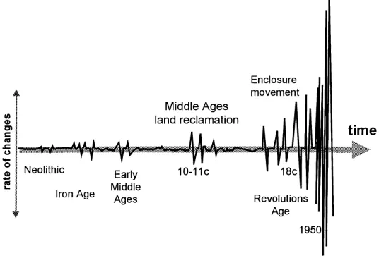
Frequency and magnitude (or scale) of the inno-vations depended on the technological possibilities which were available during the time of innovation. The diffusion of innovations is also largely controlled by cultural factors, such as religion, politics, trade, and communication. In fact both, frequency and magni-tude of landscape changes increased almost exponen-tially during history. The period from the 18th century up to the post-World War II reconstruction is crucial in the evolution of traditional landscapes. It was dur-ing this period that most of the revolutions took place, namely the Industrial Revolution, the French Revolu-tion and a whole series of wars. They resulted in abrupt changes in technology, social structures and beliefs and caused a distinct breakpoint with the past (Antrop, 1997). Fig. 2 expresses this increase in frequency and magnitude of landscape changes in Europe. Historians and historical geographers give a more detailed and diversified development (Lebeau, 1969; Pounds, 1973, 1979; Roberts, 1987; Duroselle, 1990; Verhoeve and Vervloet, 1992).
3. Landscape analysis
The analysis of a holistic phenomenon such as land-scape is not straightforward. Many approaches are pos-sible depending on the goals or perception one has, the structures that are recognised and are considered important. Equally important are the data available to study the landscape, such as (historical) maps, sur-veys, aerial photographs and remote-sensing data. The availability of spatial data in digital form is becoming more and more important in landscape analysis as ge-ographical information systems (GIS) offer powerful tools for spatial analysis. Three main approaches can be recognised.
3.1. The thematic approach: the analysis of landscape components
The thematic approach analyses different land-scape components one after the other and, finally, tries to make a synthesis. The result is a set of the-matic maps that are analysed independently, making use of different techniques. The landscape compo-nent ‘landform’, for example, can be analysed by making geomorphologic maps or analysing a digital terrain model. Components, such as ‘roads’ and ‘field structure’ might be studied with network analysis. A component such as ‘landuse’ might use shape analy-sis. Overlays techniques are frequently used to look for spatial associations and relationships between the different themes. Synthesis is achieved by composite maps.
3.2. The regional or spatial approach: hierarchical land(scape) units
Fig. 2. Conceptual graph of the frequency and magnitude of landscape evolution in Europe (after Antrop, 1997).
3.3. Landscape metrics: attempts to quantify holistic characteristics
Landscape metrics aim to describe quantitative characteristics of the landscape structure. Many of these indicators refer to abstract holistic characteris-tics of the landscape, such as heterogeneity, diversity, complexity, and fragmentation. Techniques of spatial analysis of raster maps are frequently used (Hunsaker et al., 1994). The purpose of landscape metrics is to obtain sets of quantitative data that allow a more ob-jective comparison of different landscapes for group-ing or differentiation. The landscape metrics are also intended to monitor changes in landscape structure.
4. Landscape values
4.1. Value 1: the natural framework
The natural components of the landscape form the basis of all resources and ecological functioning of the landscape. Increasing fragmentation and loss of their connectivity causes malfunctioning and, consequently, restructuring of the geographical environment.
Many natural values remain as isolated relicts lost in the superimposed landscape structured by man in a different way. Conservation of both, biological and geological/geomorphologic remains is a first value to protect. This can be achieved by creating buffer zones
and connected isolated units by corridors in order to keep their functioning going. Landscape restoration and creation are, therefore, additional instruments.
4.2. Value 2: the cultural inheritance
Landscapes are made by society and reflect the changing society and attitude towards the environ-ment. Landscapes reflect the superposition of all attempts man makes to adapt the environment to im-prove living conditions. The landscape is full of past memories, which still have a strong symbolic value. This can be seen clearly when they are exploited as tourist attractions.
Over a period of time, changes in the landscape oc-curred step by step, on a local scale; moreover, long periods of no change existed between the land reforms. So, the new structures could be integrated in a har-monic way in the existing ones. The result is a great diversity of traditional landscapes, which reflect and combine the great natural diversity of the environment and the great cultural diversity of the different ethnic groups that occupied the land.
started (Antrop, 1997). These large-scale impacts be-came possible with the Industrial Revolution, when the necessary technological power became available. Nevertheless, the modern impacts became really dev-astating after World War II with the economical boom that followed. These changes deform the traditional structures, and thus their functioning, of the existing landscapes. In some places, the traditional landscape was even wiped away entirely to create a completely new landscape. The modern landscapes are mainly characterised by uniform and rational solutions and lack identity and personality. Remnants of the tradi-tional landscape structures still exist, but became iso-lated patches in a large-scale uniformised space and are more and more difficult to recognise. In some cases, they are grouped into complexes of different landscape elements. Such complexes are referred to as ensembles,which may be used as anchor places in the management and reorganisation of the surround-ing landscape (Antrop, 1997).
Traditional landscapes can thus be defined as those landscapes having a distinct and recognisable struc-ture, which reflect clear relations between the com-posing elements and have a significance for natural, cultural or aesthetical values. In most cases, such land-scapes evolved slowly and took centuries to form the above values. Their long history allowed all changes to be integrated harmoniously with the natural condi-tions and with the previous cultural patterns. Conse-quently, a large variety of regional characteristic land-scapes were created, each of them possessing a clear identity, which is clearly expressed by their proper names. The process to create them was the slow devel-opment with few periods of change and long periods of consolidation.
Modern land reforms can be achieved by a tech-nology that can change rapidly vast areas and wipe out all existing structures. Economical rationalisation controls it and results in a uniform standard landscape ‘architecture’. All regional diversity and the identity of landscapes become unrecognisable. The spirit of the place, the genius loci, is lost.
4.3. Value 3: the aesthetically well-feeling
Man is a sensitive, feeling and appreciating being. Thus, the sense for beauty is universal, even when
the expression of beauty may differ between regions, cultures and periods. Aesthetics are also found in the way society organised the landscape during history. The most striking examples are found in gardening, which gradually evolved to landscape architecture. Landscapes that are considered having ‘outstanding beauty’ are appreciated, receive a special legal status and are sometimes protected.
The general characteristics of positive landscape as-sessment accepted by people are:
• The human scale of masses and spaces, in particular
when they are man-made.
• The order, which can be recognised, must not be too rigid. Some spatial order is needed to help orienta-tion, it expresses coherence, relationship and allows understanding. Disorder on the contrary expresses freedom and too much disorder may give an unsafe feeling. Order with a little exciting disorder makes the landscape vivid.
• Diversity and variation are appreciated as also the identity and typical (unique) character of a land-scape.
• Cleanness and a well-maintained appearance of the landscape is generally appreciated.
• Tranquillity and quietness are environmental char-acteristics of the landscape that are appreciated.
• The movement of elements in the landscape is
ap-preciated as it expresses life. Movement should be considered in its broadest symbolic sense: running or falling water, ships, cars and trains, clouds in the sky.
• A landscape is appreciated more when its potential uses are clear, when it is accessible and freedom of movement is allowed.
• The durability of a landscape is expressed in its old age (represented by monuments) and its naturalness (as a symbol for the slow evolution and growth). On the contrary, the following aspects are consid-ered as negative, disturbing, ugly, and so on:
• Everything which is too much, too few, too tall, too small, too large,...; the lack of human scale in fact.
• The occurrence of waste dumps and litter, lack of
cleanness and maintenance, extreme disorder.
• The lack of coherence, the inability to recognise relationships and meaningful patterns.
• The experience of noise and bad smell.
Also important is that man’s behaviour is condi-tioned partially by the aesthetic evaluation he makes of his environment. For example, degraded and derelict land is without order, is not clean and not well main-tained, so it receives only a poor value and ‘attracts’ spontaneous waste dumping of any kind and, thus, reinforces the degraded character.
5. Maintaining and planning landscapes
Landscape is a difficult thing to manage. The per-ceivable landscape consists of numerous pieces of land owned by many people, all of whom have pe-culiar interests, which seldom correspond. Land is private property and it is very difficult to accept that someone else tells the owner what to do with his prop-erty. Land ownership is determined by well-defined borders. Landscape transgresses these boundaries into a greater concept. Landscape is considered as a common value of the whole society. Landscape is not something to be used only by the landowners, but also by temporary visitors: recreants, tourists, and neighbours.
Landscape is multifunctional. Planning of landuse cannot be restricted to the determination of the uses of each field or land parcel. The design of the whole must be taken in account as well. Unfortunately, le-gal and technical instruments to achieve this are very limited. Only in the interior of large estates some eco-logical and aesthetical differentiation of landuse types can be planned. For most of the land, direct effects of planning are not possible and side effects, which develop in an autonomous, rather chaotic manner, are unavoidable.
The following background concepts have proved to be important in the landscape planning process.
5.1. (Open) space: the final frontier
The densely buildup land in Western Europe led to a new concept: the Open Space, referring to the land where extensive concentrations or agglomerations of buildings, constructions and infrastructures are lack-ing. The Open Space is also the rural land, the coun-tryside and the natural land. Its name reflects the most important property: a multifunctional space. Charac-teristic for the Open Space is the occurrence of open
spaces of different size, shape, arrangement and bor-dering in different ways. They characterise the land-scape. The ‘Open Space’ is a planning concept; open spaces are a physical reality. As a planning concept, Open Space means a natural resource which has a lim-ited extent and which can be used as long as a ‘stock’ is available. Economically speaking, this means that the price of ‘Open Space’ increases when it becomes scarce.
5.2. Settlements as control centres of the territory
Each human settlement is a ‘control’ centre for the territory of the social group living there. It organises the space around it according to ecological, economi-cal and psychologieconomi-cal rules. Most of these ‘rules’ act in an unconscious way. Generally speaking, the fol-lowing principles can be recognised:
• Principle 1: the land qualities to use must be di-verse. The local community will try to extend and shape their territory such that it offers the largest variety possible of natural resources, which is the best guarantee for a long lasting subsistence.
• Principle 2: the local community tries to have a permanent controlling view of the land it owns. This is reflected in the choice of the site of the settlement and the elaboration of communication between the centre and the periphery of the territory.
• Principle 3: try to keep peace with your neighbours and mark your territory. When population increases, more land has to be cleared and used. Spatial com-petition between adjacent neighbouring settlements will occur and must be regulated.
Examples are discussed by Antrop (1988 and Antrop, 1989).
5.3. The need for communication and accessibility
the surrounding landscape and its use. The most im-portant factor is the improvement of the accessibility of a region. This creates new possibilities for the use of the land, and accessibility should be expressed in terms of time or cost distance from urban and indus-trial core areas. Clearly these effects start from the access points and are characterised by diffusion pro-cesses.
5.4. Spatial characteristics of urbanisation
Since the Neolithic, human civilisation is charac-terised by increasingly large cities. In fact, man’s per-manent impact upon the natural environment began with agriculture and stockbreeding. The agrarian cul-tural landscape was created parallel to the creation of the urbanised society. Cities are complex organisms that have an important influence on their surroundings. Some of them will be discussed briefly.
5.4.1. Urban spheres of influence
Large settlements, such as towns and cities, cre-ate an internal differentiation of the space they oc-cupy to improve their global functioning. The internal spatial structure of cities may be organised in many ways. Generally speaking, the distance from the cen-tre is an important factor. Thus, more or less con-centric spheres are created around the centre. Each is characterised by a specific structure and functioning which manifests itself by a certain morphology. The concentric pattern of spheres may be disturbed by the natural conditions where the city is situated, and also by the communication network. Obviously, distance should not be considered as metric, but as time or cost distance.
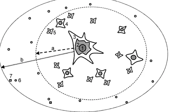
Urbanisation is the general term to designate pro-cesses of change in the rural countryside induced by the urban centres. Urbanisation acts differently in space and forms different spheres of influence around the main cities (Fig. 3).
For the planner and landscape ecologist, the most important urban spheres, though difficult to study and handle, are the inner and outer urban fringe, which can also be referred to as the rurban fringe. Rurban is formed by combining urban and rural characteristics. Two types of rurban fringe can be recognised:
• The inner fringe, which functions as the urban core, but has a complex morphology of urban and rural elements. Many open spaces are scattered between the buildup zones.
• The outer fringe, which looks like a normal rural landscape, but contains a lot of non-rural function-ing. Typically, farmsteads are not farms, but resi-dential dwellings. The structure of the landscape is rural, but its functioning is not.
Van Oort (1987) observed in the case of Rotterdam (The Netherlands) that, in the rurban fringe, very im-portant differences exist between the official landuse statistics and reality. The author makes similar obser-vations for Flemish cities. The reasons are:
• the changes in the landuse (and landscape) occur very fast, so census statistics do not ‘catch up’;
• many landuses in the rurban fringe cannot be categorised easily in the statistical classification schemes (i.e. a pasture used for keeping the horse of a city dweller); and
• many uses are not (legally) reported.
Fig. 3. Model of urbanisation patterns in Western Europe. Initial urban patterns are hierarchical structured and form a hexagonal spatial pattern. Expansion zones from the late Middle Ages up to the 19th century (2) surround the main city centre (1). The magnitude of urbanisation depends on the size of the city. The change of the surrounding rural land depends on accessibility and follows the main roads. Along the main access roads, the inner urban fringe (3) is spreading. Smaller towns (4) and villages (5) may induce urbanisation as well as form the outer urban fringe (a). Villages (6) that are situated in the urban field (b) at critical commuting distances may occasionally develop exurbs (7).
5.4.2. The hierarchical urban network
Settlements normally grow with their population and activities. Consequently, they interfere and com-pete with each other. This may lead to rivalry, but also to specialisation and increase of diversity. Historically, these processes led to a hierarchical-structured net-work of settlements, each having a unique character. The German geographer, Christaller, showed how the urban hierarchy is organised in space and what forces control its development (Christaller, 1933).
Landscapes evolve according to their situation in hi-erarchically polarised geographical space. The study of the social and economical factors in the develop-ment of cities at the different hierarchical levels may be helpful to assess the possible future development of the landscape and of its constituting elements.
Cities grew gradually and where one of the impor-tant factors of the fragmentation of the rural landscape. Many modern cities expanded along their communi-cation lines, thus forming irregular star-shaped entities cutting the Open Space. The result is a gradual and severe fragmentation of the existing rural landscape around the city. Antrop (1994) gives an example of such an evolution for some of the Flemish cities.
6. Pressures on the landscape
6.1. Pressure 1: housing and settlement
The number of people willing to live in cities still in-creases. The demand of new houses still grows even in countries where population growth is stagnating. The reasons are the increase of singular families and more and more divorces (Van Hecke and Dickens, 1994). The building of large flats, as promoted during the six-ties, proved to be the source of centres where crime developed. Thus, new housing should be small, with low buildings and, therefore, occupying large areas of the Open Space. To preserve the existing Open Space, new settlement areas have to be added to the many ex-isting small settlements and efforts should be made to preserve their non-city character as well. Open Space corridors should be created between urban developing zones.
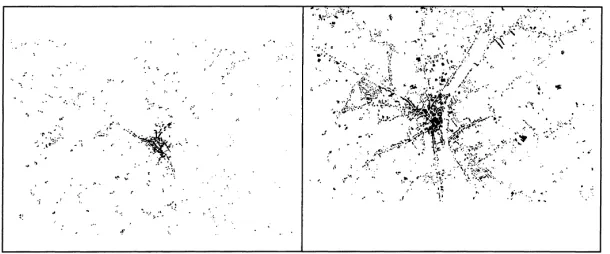
Fig. 4. Example of landscape fragmentation to the spread of urbanisation: the example of Torhout, Flanders) in 1861 (left) and 1983 (right).
6.2. Pressure 2: land as a production space
In western society, agriculture is not the main source of economical productivity and farmers form a mi-nority. Nevertheless, they are considered as the most important actors in the maintenance of vast areas of Open Space. In the future, the finality of agriculture will become less focussed on economical productiv-ity, but more on maintenance of an ecologically equi-librated environment in the Open Space and its multi-functional use.
6.3. Pressure 3: networks of infrastructure
All ancient civilisations had trade routes that formed one of the basics for their subsistence, ever since com-munication networks connected the early urban cen-tres and economical cores of production. During his-tory these networks have been intensified and become denser. Certain connections disappeared and new ones were created when the core areas of civilisation shifted in the geographical space. Innovations in transporta-tion and communicatransporta-tion resulted in new networks, which were superimposed upon the existing ones. For Western Europe, the coming of the railway in the 18th century and the automobile after the Second World War are the most important innovations that introduced many new changes in the landscape.
Modern society lives by dense international com-munication networks. The latter form large structures superimposed as alien objects upon the landscapes that they dissect. Ecological and economical fragmentation and aesthetical disfigurement result from this develop-ment. These networks may have no relation at all with
the environment they cross. Nevertheless, they may become the initiators of new development. Roads may disclose untouched areas and initiate new economical or recreational activities, which in the end may cause a lot more harm than the road infrastructure ever did. The following stages in the development of road networks can be recognised in Europe:
1. The ancient networks that developed up to the 18th century.
2. The first ‘national’ (stage) road network that was developed in the political centralised states. 3. The railroad network, starting form the 18th
cen-tury in England and in the 19th and early 20th centuries in continental Europe.
4. The motorway network that was gradually devel-oped since the sixties.
5. The high-speed railway network actually under development.
Places where connections are made to a commu-nication network are privileged for fast new develop-ment. These access nodes act as initiators and attrac-tors of new changes in their immediate environment. Fig. 5 illustrates the indirect effect of building initiated by the European motorway E17 between Lokeren and the tunnel at Antwerp. New construction occurred be-tween 1965 and 1988 closer to the access points and gradually diffused from these.
6.4. Pressure 4: recreation
Fig. 5. New infrastructure as initiator of uncontrolled development: the example of the E17 motorway between Lokeren and Antwerp, Flanders. Planned road in 1965 and motorway in 1988 with access nodes. Small dots represent buildings.
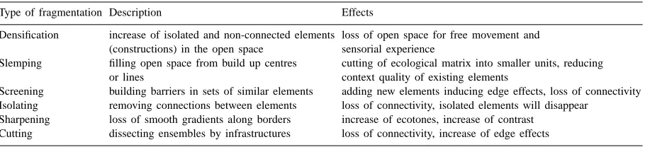
Table 2
Types of fragmentation in and the effects on the landscape
Type of fragmentation Description Effects
Densification increase of isolated and non-connected elements loss of open space for free movement and (constructions) in the open space sensorial experience
Slemping filling open space from build up centres cutting of ecological matrix into smaller units, reducing or lines context quality of existing elements
Screening building barriers in sets of similar elements adding new elements inducing edge effects, loss of connectivity Isolating removing connections between elements loss of connectivity, isolated elements will disappear
Sharpening loss of smooth gradients along borders increase of ecotones, increase of contrast Cutting dissecting ensembles by infrastructures loss of connectivity, increase of edge effects
of the coastlines of Europe. This form of recreation is now gradually moving inland, searching for un-touched natural landscapes of forests, hills, moun-tains, and so on. The human pressure for recreation has already caused a lot of harm to all these fragile ecosystems, which had to be protected and recreation had to be restricted and contained. Now the recreation pressure moves towards the rural landscapes, causing new types of problems, especially with other users of the landscape, in particular the farmers. Also, vast ‘natural’-looking areas are prospected as environment for recreational parks.
6.5. Landscape fragmentation
Ensembles may be disturbed or degraded in several ways. Fragmentation is the most common. Different types of fragmentation can be recognised. They af-fect cultural, historical as well as natural ensembles, but also the larger landscape structures, such as field,
vegetation and settlement patterns. Fragmentation is caused by a sudden impact (as cutting by a new road) or the result of a gradual process. Table 2 shows the typology of the fragmentation as adopted in Flanders (adopted from Antrop et al., 1994).
A second form of disturbance of an ensemble is caused by the loss of its functionality. In many cases, this leads to degradation and decay. In other cases, it may lead to a change of its structure, related to the creation of a new functionality. The general rule is: what has no use anymore, degrades and, finally, disappears.
7. Conclusion
can be perceived in the increasingly faster changing landscape. Perception determines the valuation in an important manner. In order to understand the actual changes an integrated approach is needed. Studying single themes or landscape components does not allow understanding the complex processes of urbanisation that affect the rural countryside at even remote places. Integrated analysis should focus upon the continuous interaction between spatial structure and functioning at different hierarchical scale levels.
References
Antrop, M., 1998. Landscape change: plan of chaos?. Landscape Urban Planning 41, 155–161.
Antrop, M., 1997. The concept of traditional landscapes as a base for landscape evaluation and planning. The example of Flanders Region. Landscape Urban Planning 38, 105–117.
Antrop, M., 1995. Educating holistic looking and knowledge integration. Banská Štiavnica. UNESCO Chair Workshop on ‘The methodological problems of the education of ecological awareness’.
Antrop, M., 1994. Landscapes of the urban fringe. In: Goossens, M., Van Hecke, E. (Eds), Van Brussel tot Siebenbürgen. Progress in human geography in Europe. Liber amicorum Prof. Dr. H. Van der Haegen. Acta Geographia lovaniensia 34: 501–514.
Antrop, M., Dhondt, A., Mathyssen, E., Van Damme, S., 1994. De versnippering van de Open Ruimte. MIRA, Mechelen, VMM en Leuven, Galant.
Antrop, M., 1993. The transformation of the Mediterranean landscapes: an experience of 25 years of observations. Proceedings International Symposium on The Future of Mediterranean Landscapes, Montecatini. Landscape Urban Planning 24, 3–13.
Antrop, M., 1991. Rethinking Carrying Capacity. Proc. European IALE-Seminar on Practical Landscape Ecology, Vol. III. Roskilde University Centre, pp. 55–64.
Antrop, M., 1989. Het landschap meervoudig bekeken. Kapellen, Pelckmans, 400 p.
Antrop, M., 1988. Invisible connectivity in rural landscapes. In: K.-F. Schreiber (Ed.), Connectivity in Landscape Ecology. Proceedings 2nd International Seminar of IALE. Münsterische Geographische Arbeiten 29. Münster, pp. 57–62.
Christaller, W., 1933. Die zentraler Orte in Suddeutschland. Jena, Fischer.
Duroselle, J.-B., 1990. L’Europe. Histoire de ses peuples. Lib. Acad. Perrin et Bertelsmann Lexikon Verlag.
Forman, R., Godron, M., 1986. Landscape Ecology. Wiley & Sons, New York.
Howard, J., Mitchell, C., 1980. Phyto-geomorphic classification of the landscape. Geoforum 11 (2), 85–106.
Hunsaker, C.T., O’Neill, R.V., Jackson, B.L., Timmins, S.P., Levine, D.A., Norton, D.J., 1994. Sampling to charaterize landscape pattern. Landscape Ecol. 9 (3), 207–226.
Lebeau, R., 1969. Les grands types de structures agraires dans le monde. Masson, Paris.
Mitchell, C., 1973. Land evaluation. Longman, London. Naveh, Z., Liebermann, A., 1993. Landscape ecology: Theory and
Application. Springer Verlag, New York.
Pounds, N., 1973. A Historical Geography of Europe. Cambridge University Press, Cambridge, 475 p.
Pounds, N., 1979. A Historical Geography of Europe, Cambridge University Press, Cambridge, 438 p.
Prigogine, I., Stengers, I., 1987. Orde uit Chaos. Uitg. Bert Bakker, Amsterdam.
Roberts, B., 1987. The Making of the English Village. Longman, London, 237 p.
Troll, C., 1950. Die Geographische Landschaft und ihre Erforschung. Studium Generale, pp. 163–182.
Van Hecke, E., Dickens, C., 1994. Bevolking. In: Verbruggen, A. Leren om te Keren. Milieuen Natuurrapport Vlaanderen. Vlaamse Milieuvereniging en Garant Uitg., pp. 45–61. Van Oort, G., 1987. Theoretical dimensions of a conceptual model
of the rural-urban fringe. I.G.U. Conference, Varanasi, India, 12 p.
Verhoeve, A., Vervloet, J. (Eds.) 1992. The Transformation of the European Rural Landscape: Methodological Issues and Agrarian Change 1770–1914. Tijdschrift van de Belg. Ver. voor Aardrijkskundige Studies, LXI, 1.