OPENGIS PROJECT DOCUMENT 00-117a
TITLE: Topic 17: Location-Based/Mobile Services
AUTHOR: Name: Cliff Kottman
Address: OGC
Phone:
FAX:
Email:
DATE: 15 May 2000
CATEGORY: Draft Abstract Specification
The OpenGIS Abstract Specification: Page 2 An Object Model for Interoperable Geoprocessing,
Open GIS Consortium
35 Main Street, Suite 5Wayland, MA 01778 Telephone: +1-508-655-5858
Facsimile: +1-508-655-2237 Editor:
Telephone: +1-703-830-6516 Facsimile: +1-703-830-7096
The OpenGIS™ Abstract Specification
Topic 17: Location-Based/Mobile Services
Proposed
Draft, Version 0.0
Copyright © 2000, Open GIS Consortium, Inc.
NOTICE
The information contained in this document is subject to change without notice.
The material in this document details an Open GIS Consortium (OGC) specification in accordance with the license and notice set forth on this page. This document does not represent a commitment to implement any portion of this specification in any companies’ products.
While the information in this publication is beleived to be accurate, the Open GIS Consortium makes no warranty of any kind with regard to this material including but not limited to the implied warranties of merchantability and fitness for a particular purpose. The Open GIS Consortium shall not be liable for errors contained herein or for incidental or consequential damages in connection with the furnishing, performance or use of this material. The information contained in this document is subject to change without notice.
The Open GIS Consortium is and shall at all times be the sole entity that may authorize developers, suppliers and sellers of computer software to use certification marks, trademarks, or other special designations to indicate compliance with these materials.
This document contains information which is protected by copyright. All Rights Reserved. Except as otherwise provided herein, no part of this work may be reproduced or used in any form or by any means (graphic, electronic, or mechanical including photocopying, recording, taping, or information storage and retrieval systems) without the permission of the copyright owner. All copies of this document must include the copyright and other information contained on this page.
The OpenGIS™ Abstract Specification Page i
Revision History
Date
Description
The OpenGIS™ Abstract Specification Page iii
Table of Contents
1.
Introduction ...1
1.1.
The Abstract Specification... 1
1.2.
Introduction to Location-Based/Mobile Services... 1
2.
Background for Location-Based/Mobile Services ...2
2.1.
Overall Objective ... 2
2.2.
The “Device” ... 2
2.3.
Some Device Types... 2
2.3.1. Spatially Enabled Fixed Objects ...2
2.3.2. Spatially Enabled Mobile Objects ...2
2.3.3. Other Characteristics that Distinguish Devices...2
2.4.
General Location Concepts... 2
2.5.
Some Popular Location Types ... 2
2.5.1. Point Geometries ...3
2.5.8. Azimuth, Range, and Elevation ...5
2.5.9. Pathway...5
2.5.10. Types of Pathway...5
2.5.11. Descriptive Directions...6
2.6.
Location Accuracy ... 6
2.7.
Similarities to Existing OGC Specifications... 6
3.
Essential Model for Location-Based/Mobile Services ...7
3.1.
The Fundamental Interfaces... 7
3.1.1. GetLocation...7
3.1.2. GetLocation (for a fixed target device)...7
3.1.3. GetLocation (for a mobile target device)...8
3.1.4. The Catalog of Fixed Devices ...8
3.1.5. The Backdrop for Human Understanding ...9
3.1.6. Public Information (Government Data) Catalogs ...9
3.1.7. The Information Community of Retail Goods and Service Providers...9
3.1.8. The analogy with the White Pages, Yellow Pages, and Green Pages...9
3.1.9. The White Pages...9
3.1.10. The Location-Based/Mobile Enabled White Pages ...9
3.1.11. The Yellow Pages...9
3.1.12. The Location-Based/Mobile Enabled Yellow Pages ...10
3.1.13. The Green Pages ...10
3.1.14. The Location-Based/Mobile Enabled Green Pages...10
3.1.15. Regional Information Communities of Retail Goods and Service Providers ...11
3.2.
Protecting Privacy... 11
The OpenGIS™ Abstract Specification Page iv
3.2.2. Employ a Proxy Service...11
3.2.3. Issue a Certificate...11
3.2.4. Other Approaches to Privacy ...11
3.3.
Additional Interfaces... 11
3.3.1. WhereIsItInTermsIUnderstand ...11
3.3.2. BuildPathway ...11
3.3.3. Who'sThere ...11
3.3.4. Other Interfaces ...12
3.4.
Services ... 12
3.4.1. Transformations...12
3.4.2. Multiple Coordinate Reference Systems ...12
4.
Abstract Specification for Location-Based/Mobile Services...12
4.1.
Services ... 12
4.1.1. Discussion ...12
4.1.2. Object Model ...12
4.1.3. Class Name: ...12
4.2.
Package Dependencies ... 12
5.
Well Known Structures ...12
6.
Future Work ...12
7.
Appendix A. Acronyms and Glossary...13
7.1.
Acronyms... 13
7.2.
Definitions... 13
The Open GIS Abstract Specification Page 1
2. Introduction
2.1. The Abstract Specification
The purpose of the Abstract Specification is to create and document a conceptual model sufficient enough to allow for the creation of Implementation Specifications. The Abstract Specification consists of two models derived from the Syntropy object analysis and design methodology [1]. The first and simpler model is called the Essential Model and its purpose is to establish the conceptual linkage of the software or system design to the real world. The Essential Model is a description of how the world works (or should work).
The second model, the meat of the Abstract Specification, is the Abstract Model that defines the eventual software system in an implementation neutral manner. The Abstract Model is a description of how software should work. The Abstract Model represents a compromise between the paradigms of the intended target implementation environments.
The Abstract Specification is organized into separate topic volumes in order to manage the complexity of the subject matter and to assist parallel development of work items by different Working Groups of the OGC Technical Committee. The topics are, in reality, dependent upon one another each one begging to be written first. Each topic must be read in the context of the entire Abstract Specification.
The topic volumes are not all written at the same level of detail. Some are mature, and are the basis for Requests For Proposal (RFP). Others are immature, and require additional specification before RFPs can be issued. The level of maturity of a topic reflects the level of understanding and discussion occurring within the Technical Committee. Refer to the OGC Technical Committee Policies and Procedures [2] and Technology Development Process [3] documents for more information on the OGC OpenGIS™ standards development process.
Refer to Topic Volume 0: Abstract Specification Overview [4] for an introduction to all of the topic volumes comprising the Abstract Specification and for editorial guidance, rules and etiquette for authors (and readers) of OGC specifications.
2.2. Introduction to Location-Based/Mobile Services
This topic volume is the portion of the OpenGIS™ Abstract Specification that covers location-based/mobile services. That is, this part of the abstract specification describes services that take advantage of mobility and the position or relative position of devices and points, lines, or polygons of service. Important concepts are location, route, and types of service.
References for Section 1
[1] Cook, Steve, and John Daniels, Designing Objects Systems: Object-Oriented Modeling with Syntropy, Prentice Hall, New York, 1994, xx + 389 pp.
[2] Open GIS Consortium, 1997. OGC Technical Committee Policies and Procedures, Wayland, Massachusetts. Available via the WWW as <http://www.opengis.org/techno/development.htm>. [3] Open GIS Consortium, 1997. The OGC Technical Committee Technology Development Process,
Wayland, Massachusetts. Available via the WWW as <http://www.opengis.org/techno/development.htm>.
The Open GIS Abstract Specification Page 2
3. Background for Location-Based/Mobile Services
This topic volume is the portion of the OpenGIS™ Abstract Specification that covers location-based/mobile services. This section provides background information useful in understanding the Location-Based/Mobile Services discussed in later sections.
3.1. Overall Objective
This part of the abstract specification describes Location-Based/Mobile services. These services are important because they empower devices and users with devices to take advantage of their location or mobility, or to take advantage of the location or mobility of other devices or objects with devices.
3.2. The “Device”
The notion of “device” used here includes cell phones, palm tops, and other information technology components with similar characteristics. Included are lap-tops, kiosks, dash board or automobile-based computers, satellite-automobile-based components, cell antennae, and so on. Especially included are mobile devices.
3.3. Some Device Types
Devices fall into categories according to their capabilities. Examples follow.
3.3.1. Spatially Enabled Fixed Objects
A spatially enabled fixed object is able to expose its geometry when prompted to do so. In this way, the object behaves like more general devices that are able to report their location when queried. A city or a park may expose a polygon (or several polygons). A street or stream may expose a line. A dwelling may expose an address. A feature that carries an attribute with name “PlaceName” may expose the value of this attribute.
3.3.2. Spatially Enabled Mobile Objects
A mobile object may be able to report its location continuously or periodically. The location may be absolute (e.g., as a point a global coordinate system) or relative to other fixed or mobile objects such as satellites or antennae.
3.3.3. Other Characteristics that Distinguish Devices
Devices may be characterized by the following characteristics and circumstances. a. A device may be associated with (attached to) a human
b. A device may be able to communicate its location to the Net
c. A device may be able to display a location in the context of a map or image backdrop
3.4. General Location Concepts
Human cultures have evolved a large number of location concepts or “types”. Different location concepts are used in different situations. This Abstract Specification applies natural location concepts to devices, either one device at a time (e.g., where is a specified device?) or to pairs of devices (e.g., in order to go from device 1 to device 2, what direction must one travel? The underlying goal is to enable the communication of location information between a human and a device, or between two devices.
We often assume that every geospatial object has a device dedicated to it that “knows” where the object is. If the spatial object is mobile, then the device dedicated to it should know additional information, such as: velocity, destination, estimated time of arrival, and so forth.. While this seems an extreme assumption, it helps clarify the universe from a Location-Based/Mobile Services point of view. Actually, it is not such an extreme assumption for fixed (non-mobile) features, because most fixed features have a geometry property, and the interface that exposes the geometry of a feature acts as a kind of “device proxy” for the feature.
The Open GIS Abstract Specification Page 3
3.5.1. Point Geometries
The simplest type of Location is modeled with a point geometry. The point geometry may have two- three- or four- spatiotemporal coordinates and may carry semantics, quality, and authority information as well.
A point location is often described with a set of coordinates. The location can be a. Along an axis, (at (x)), or at that point at time t (x,t), b. In a plane (at (x,y)), or at that point at time t (x,y,t) c. In three space (at (x,y,z)), or at that point at time t (x,y,z,t)
Spatial coordinates need to convey their meaning (e.g., axis name, units, origin, and datum). Sometimes an additional temporal coordinate is useful to denote the time when a particular device occupied the location; it needs axis name, units, origin and datum, too.
A two-tuple (x,y) is often presented as a point on a (backdrop) map, or on an image; but for now we ignore the issue of finding an appropriate backdrop.
One or more quality parameters may provide horizontal and vertical error measures (such as standard variation, or 90% confidence values.) The “authority” provides a way to distinguish more trusted sources from others with less trust.
Many mobile devices will obtain their Location using GPS satellites, or using cell phone location technology. The errors in such location depend on the technology used and other factors.
3.5.2. Location Name
Location names may refer to point, line, or polygon regions. Examples include names of: Country, Province, County, Jurisdiction, City, Neighborhood, Parcel, and so on. If we allow a feature Identification to be a kind of “place name”, then each identified Feature becomes a potential Location of Type “Location Name.”
Special “types” of Location Names are provided by Postal Zones, Telephone Area Codes, Census Tract identifiers, Time Zones, and similar artificial divisions of a region. It is understood that many Location Names refer to places with soft boundaries: the Rockies, the Piedmont, and the South China Sea for example. For now, we ignore this complication.
There is another complication: Objects are easily confused with their names, and with their models. For example, is the difference between these alternatives clear?
a. The current feature, F, is the North Pole
b. The name of the current feature, F, is “The North Pole.”
c. The current feature, F, is modeled with the coordinates (rminor, 0, 90).
For now, we ignore this complication also. It will be resolved by the emergence of discipline ontologies and formal naming services.
Editor’s Note: It is recognized that the following lists are too specific for an Abstract Specification. They are included strictly as illuminating examples.
Location Names could carry an interface that provides the category of feature that carries the name. For example, a place name might be able to report that it is the name of:
The Open GIS Abstract Specification Page 4 <p7> small neighborhood (a few blocks)
<p8> parcel b. A Populated Place
<h1> metro area over 10 million people <h2> metro area over 1 million people <h3> city over 100,000 people <h4> small city over 10,000 <h5> town over 1,000 <h6> town over 100 <h7> village over 10 <h8> village of 10 or fewer c. A Road, Track, or Path
<r1> multi-lane divided road <r2> other multi-lane primary road <r3> other primary road
<r4> secondary road <r5> tertiary road <r6> dirt track for vehicles <r7> dirt track for 4WD vehicles <r8> path or trail
d. flowing water... (rivers, streams, aqueducts, washes...) e. bodies of water... (oceans, seas, lakes, ponds...)
and so on.
3.5.3. Segmented Line
A powerful method of specifying a Location is by defining a point or interval along a linear feature. Examples:
a. 300 yards north of mile marker 143 on Interstate 66.
b. Between two and three miles downstream from reactor 3 on Two Mile Island. c. Third door on the right down this hall.
d. At the intersection of 4th street and the city limits.
Implementation of this method might need to be postponed until the necessary geometric structures, such as parameterized lines, are erected in Topic 1.
3.5.4. Address and Address Range
A street-name-and-number address is a special case of a segmented line. Each address along a block-edge segments the street segment that fronts that block. Similarly, an address range can be used to communicate a segment of a road.
3.5.5. Types of Address Structures
It is recognized that there are many types of Address Structures. They include: a. Post office boxes
The Open GIS Abstract Specification Page 5 d. Apartment numbering
e. Address schemes of different countries
Location-Based/Mobile Services will include the ability to exploit and generate these types one-by-one, and will become increasingly robust over time.
3.5.6. Relative Locations
Often a less-understood location is communicated using better-understood landmarks. The next several paragraphs are special cases of Relative Locations
3.5.7. Azimuth and Range
Here, a well-known landmark (such as one’s present location in a two dimensional environment) is used as the pole in a local polar coordinate system. Another location can be specified in terms of (rho, theta) range and azimuth coordinates. This approach assumes that the user already has established the origin of the azimuth variable (this may require a compass or gyroscope or electronics generating equivalent information.) The information exchanged in this example is sometimes called “Delta Vector from a Landmark.”
3.5.8. Azimuth, Range, and Elevation
This is just like the example above, except a third dimension is introduced. A location is specified by the Range (distance from the pole), Azimuth (angle counterclockwise from the polar axis, or North), and Elevation (a positive Elevation angle indicates a Location “above” the polar plane.
3.5.9. Pathway
A pathway from device 1 to device 2 is a sequenced collection of single-point and linear geometries such that
a. For two consecutive geometries, A and B, in the collection, the last point of A is the first point of B.
b. The first point of the first geometry is the location of the first device. c. The last point of the last geometry is the location of the second device.
A logical condition on a pathway is that all the linear geometries of which it is composed are the geometries of features that support transportation of an appropriate type (automobile, bicycle, etc.) Single-point geometries are included to hold intersections with “turn” information, schedules, change of modality (from train to bus, for example), and so on.
3.5.10. Types of Pathway
There are several types of pathway:
a. An automobile pathway consists of the geometries of streets, highways, car parks, and other features supporting automobile traffic.
b. A bicycle pathway consists of geometries intended for bicycle traffic. c. A pedestrian pathway consists of geometries of features supporting pedestrian
traffic.
d. A public transportation pathway may consist of bus routes (stops and the paths that connect them), rail stations and tracks, multi-modal junctions, and so on.
e. The pathway used by a package in a delivery system.
f. Electronic pathways with routers, cables, fiber, and antennae. Start and end points are devices.
g. other
A pathway may be parameterized so that it models a point moving continuously from device 1 to device 2.
The Open GIS Abstract Specification Page 6 does not fit actual conditions. For example, a search for alternative pathways may be triggered when progress along a baseline pathway falls more than 5 minutes behind schedule.
3.5.11. Descriptive Directions
A powerful and widely used method for communicating the location of a device to another is to provide a set of (verbal, natural language) instructions that, if followed properly, generate a pathway from the first device to the second.
Many car rental sites provide a service to generate written instructions of this type to nearby hotels and points of interest. This Abstract Specification insists that such instructions be “parsable” into a pathway; that is, that the descriptive instructions be mapped in a one-to-one fashion into pathways.
3.6. Location Accuracy
Location-Based/Mobile Services assume that most coordinates have a relatively high precision and corresponding accuracy. Ground coordinates might be known or desired with an accuracy between a few tens of meters and a few centimeters.
The numerical values ground coordinates always have limited accuracies. If the accuracy is known, that accuracy should be communicated from the data producer to the data user, so that the data user can properly interpret and use the numerical value. Topic Volume 9 specifies in considerable detail the accuracy data mentioned only briefly elsewhere in the Abstract Specification.
3.7. Similarities to Existing OGC Specifications
The objects and methods found in Location-Based/Mobile Services have many commonalties with those in other parts of the OGC Specifications. These commonalties include:
1. Use similar interface data, including position coordinates and metadata about these coordinates 2. Need many different coordinate transformations
3. Need to use a common software framework, to simplify use of many different coordinate transformations
4. Need metadata about the coordinate transformations
5. Use ground coordinate transformations within image coordinate transformations
However, image coordinate transformations have certain differences from ground coordinate transformations. These differences include:
1. Decrease or increase the number of position coordinate dimensions, by an image coordinate transformation
2. Need many different image coordinate transformations for different image geometry types and different image versions
3. Less standardization now exists of image coordinate transformations, especially of image geometry models
The Open GIS Abstract Specification Page 7
4. Essential Model for Location-Based/Mobile Services
This section presents an Essential Model for Location-Based/Mobile Services.
4.1. The Fundamental Interfaces
There are a small number of fundamental interfaces that support Location-Based/Mobile Services.
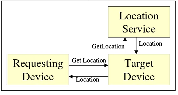
4.1.1. GetLocation
The generic interface discussed in this Section requests a Location be generated for a named or identified device and to have this Location returned to the requesting component. The requesting component might ask for its own Location. (In this case, the Location might be generated internally with a GPS receiver, for example, or generated externally and then passed to the requesting component). The Location returned usually consists of coordinates defining a point, and is accompanied with coordinate system information, accuracy information, currency (and/or time-to-live), the authority of the information returned, and perhaps other information.
Figure 3.1.1 The GetLocation Interface
When a device requests its own Location, it invokes a Location Service with a GetLocation interface as shown in Figure 3.1.1
4.1.2. GetLocation (for a fixed target device)
The WhereIsIt interface is often issued to global and regional catalog servers that might specialize in listing the Locations of regional restaurants, garages, museums, parks, walking tours, and other points, lines, and polygons of service. Retail outlets may play a large role here. In this Section, it is assumed that the Location sought is not mobile, but fixed instead. The interface may be cascaded to servers with specific site information such as: hours of operation, a local map, what’s on sale, reservations, phone number, etc. The interface may open a dialog with a selected service provider, or with a candidate one. The interface, when desired, returns nearest service, next nearest, and so forth, taking into account the kind of routes available (such as for a car, for a pedestrian, etc.), and, if available, local traffic conditions.
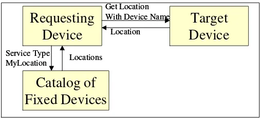
Figure 3.1.2 WhereIsIt for a fixed target device
The Open GIS Abstract Specification Page 8 Figure 3.1.2 shows two alternatives for obtaining the Location of a fixed (not mobile) device. The first is to simply ask the fixed target device to expose its Location. In this case, one must know the name of the target device in advance.
In the second case, one might not know what target devices are available or nearby, or not know their names. In this case, the requesting device issues a request to one or more catalogs (that may be regional or global) specifying the type of desired service, and providing the Location of the requesting device (or some other Location) where the service is needed. The catalog(s) return a list of Locations (and perhaps other information) of the services of the desired type nearby the specified Location. For example, the WhereIsIt interface could request the server to return the three service locations of a specified type that are nearest to a specified Location.
4.1.3. GetLocation (for a mobile target device)
The sought-after point of service may itself be mobile, in which case a recent location and velocity is returned. The target device is asked for its position. If it does not know its current position, it may have to ask a Location service. Figure 3.1.3 show the situation.
Figure 3.1.3 Obtaining the Location for a Mobile Device
Alternate architectures are possible. For example, some component may “keep tabs” on certain mobile devices (such as a fleet of trucks.) Now a device requesting the Location of a truck need not query the mobile device directly, but instead may directly query the component “keeping tab.”
4.1.4. The Catalog of Fixed Devices
The contents of each Catalog of Fixed Devices (see section 3.1.3) should be highly dependent on the information community to which the information seeker belongs, and on the abstraction level of the catalog. For example, an electric power distribution company may support a number of feature collections that may hold models of its poles, conductors, conduits, manholes, transformers, and other devices of interest to that information community. This company may additionally support one or more catalogs that provide access to these feature collections.
Another electric power distribution company may support catalogs of its own with entirely different entries, but with the same schema, that is, with the same catalog or feature types and metadata.
From a national or global point of view, these regional catalogs collectively cover the electrified world. There may be additional layers of catalogs of such catalogs providing uniform national or global access to features of interest to the electric power distribution information community. The geographic extent of each these catalog is determined the various company’s service areas, and by how these areas are aggregated in the abstraction process. Of course, if there are differences in schema across regional boundaries, there will need to be thesauri or semantic translators that bridge differing community schemas.
In this way, one can imagine that the global electric power distribution community has all of its feature information accessible through a single, global “root” catalog that provides access to various national or regional catalogs, each of which provide access in a cascading fashion to a
The Open GIS Abstract Specification Page 9 family of smaller regional electricity-distribution-information-community catalogs, arriving ultimately at catalogs of feature collections of interest to that community.
4.1.5. The Backdrop for Human Understanding
A component or device that requests a Location may use a returned coordinate in an algorithm (for example, in a shortest path algorithm to discover whether the Location is on a shortest path.) A more common scenario is for the requesting device or component to use the returned coordinate to create a human-readable display intended to inform the human about the Location in a context of familiar surrounding features (such as roads or imagery) For example, the returned coordinate might be a represented as a red star on a topographic map. The backdrop may be generated using Web Mapping interfaces, or by using an extension of them.
In any event, there must be a well-known source of backdrop data (maps or images) that stands ready for employment in support of backdrop generation
4.1.6. Public Information (Government Data) Catalogs
Most national, regional, and local government information will be made available (to qualified persons and systems) using catalogs similar to that of the electric power distribution information community. These catalogs will not be strictly independent of each other. For example, poles might appear in both power distribution and telephone catalogs. Streets will be found in many catalogs, as they are such important reference features.
Each catalog will have a region of application that may be global or small. Each catalog’s region of application is the union of all the areas of application of the catalogs and feature collections it lists. The area of application of a feature collection is determined by the union of the geometries of its features.
4.1.7. The Information Community of Retail Goods and Service Providers
The information community of utmost interest to Location-Dependent/Mobile Services is the community of retail goods and service providers. This community provides information that services queries such as:
Where is the hardware store most convenient to my route home? What are the three termite control offices nearest my home?
The following several sections provide insight to the catalogs that will service these queries.
4.1.8. The analogy with the White Pages, Yellow Pages, and Green Pages
Today’s telephone-enabled environment is supported with White Pages, Yellow Pages, and Green Pages. Each provides a useful analogy to Location-Based/Mobile Services.
4.1.9. The White Pages
Today, white pages support the discovery of telephone numbers of telephones associated with individual humans or groups of humans. The phone that rings when this number is dialed might be fixed in the individual’s home, or it may be carried with an individual (as a cell phone or satellite phone). Today’s White Pages are published in books where each book covers a “service area.” There are tens of thousands of service areas that cover the globe. For a fixed telephone, its service area ordinarily includes the region that can be accessed with a “local call” and may include some nearby regions serviced with “long distance.” The concept of “service area” is more complex for mobile phones, but usually includes a large number of cells that constitute the “home region” of the phone. For a satellite phone, the service area may be global.
4.1.10. The Location-Based/Mobile Enabled White Pages
From a Location-Based/Mobile point of view, the White Pages are nearly the same as they are from a traditional point of view. Devices will replace telephones, and they will support the discovery of the names of other devices that are associated with individual humans. Today’s voice-to-voice dialogs will be complemented with the device-to-device and voice-to-device dialogs, depending on the subject. In many ways, this is already happening with smart pagers and palm devices.
The Open GIS Abstract Specification Page 10 The Yellow Pages of today’s phone books provide a nearly exhaustive listing of retail (and, for that matter, wholesale) regional outlets for goods and services. Today’s Yellow Pages are published in books where each book covers a region of the earth called a “service area.” There are tens of thousands of regional service areas and their union covers the globe. Service areas often overlap. Each fixed phone is usually issued a phone book with yellow pages for a region more or less centered on the phone’s location. Within each service area, a Yellow Pages publisher solicits subscribers who are charged for inclusion in the Yellow Pages, and are additionally charged for any physical space (with art work, advertising, and so on) “leased” in the Yellow Pages. The Yellow Pages only provide generic information about their goods and services, such as:
Telephone Number Address
Hours of operation Nearby landmark
Specialty (kind of doctor or restaurant) General purpose advertising
Other information is often available only by dialing the number and engaging in a dialog with the proprietor as human-to-human. This is the case, for example, when one wants to know: The name of the movie at the theater and its start tiime
The waiting time for a table at a restaurant.
4.1.12. The Location-Based/Mobile Enabled Yellow Pages
When the Yellow Pages are Location-Based/Mobile enabled, they can support much more sophisticated behaviors. Note that the enabled Yellow Pages are still regional (although the region boundaries may become totally transparent to a user.) This is because within each service area, an enabled Yellow Pages publisher solicits subscribers who are charged for inclusion in the enabled Yellow Pages, and who are additionally charged for any virtual space (with real-time pictures, Java animation, advertising, and so on) “leased” in the enabled Yellow Pages. The enabled Yellow Pages provide generic information about their goods and services, and additionally provide new types of information such as
The hardware store most convenient to my route home The three termite control offices nearest my home The nearest screening of a named movie
The name of the movie and its start time at an identified theater The waiting time for a table at a restaurant
Tonight’s special menu at that restaurant.
There is essentially no limit on the depth and scope of the information that can be provided by an enabled Yellow Pages. This facility derives from the fact that enabled Yellow Pages may be updated at any moment, whereas traditional Yellow Pages may be updated only on a (usually annual) cycle due to their physical nature.
One large difference between ordinary Yellow Pages and enabled Yellow Pages is in the area of mapping and routing. Ordinary Yellow Pages can only show static maps, or provide general route descriptions (when arriving from the West, turn at …, etc.) Enabled Yellow Pages can provide access routes and maps generated specifically for your special case.
4.1.13. The Green Pages
The Green Pages are an index into the Yellow Pages. That is, the Green Pages are an authoritative list of the topics found in the Yellow Pages. Thus, the Green Page entries are a sort of metadata for indexing the Yellow Pages.
The Open GIS Abstract Specification Page 11 For the most part, enabled Green Pages behave just like ordinary Green Pages. There may be a few subject areas in which enabled Green Pages may have an index entry in addition to those of ordinary Green Pages.
4.1.15. Regional Information Communities of Retail Goods and Service Providers
Today’s providers of retail goods and services form an information community joined by the Yellow Page volumes in which they advertise. The same is true for spatially enabled providers.
4.2. Protecting Privacy
There may be a privacy issue with Location Based services. For example, the location of a person (or personal device) may be requested. The following few sections show some of the approaches that may be used to protect privacy.
4.2.1. Allow No Proxies
In the no-proxy scenario, all requests for the location of a personal device must be serviced by the personal device itself. The owner of the device may adjust parameters in the device to allow, disallow, or selectively allow his or her location to be exposed.
4.2.2. Employ a Proxy Service
Mobile devices could delegate to proxy servers the business of exposing their Location. Such a proxy could maintain a list of devices that are allowed to receive Location information to specific personal devices. When a request for a personal device Location is received by the Proxy, it checks its list and behaves accordingly.
4.2.3. Issue a Certificate
In the certification architecture, the Location interface raises an exception unless the interface invocation is accompanied with a certificate allowing the location to be exposed. Certificates are issued by special components on the Net. Owners of personal devices may be able to influence the criteria by which certificates are issued and denied. An advantage of this architecture is that it provides for certain authorities to use Location services in emergencies.
4.2.4. Other Approaches to Privacy
Other approaches to privacy are possible. For example, a personal device may provide selective accuracy. In this scheme, a personal device will only expose the county or country in which the device is located, and more precise information only to those with a password.
4.3. Additional Interfaces
4.3.1. WhereIsItInTermsIUnderstand
This interface might also be called LocationTranslator because it translates from one form of Location to another. This interface converts (often useless) location information (such as latitude, longitude, and elevation) into new structures that are useful to the task at hand (such as a postal address, a jurisdiction name, place name, position relative to a monument, a polygon on a map backdrop, driving instructions, and so forth. This interface must be able to convert between location "types" (such as from "the intersection of Rt 50 and the city limits" to latitude and longitude.
4.3.2. BuildPathway
The BuildPathway interface accepts origin and destination information (and real-time information such as traffic conditions, if it is available) and returns a pathway in a choice of "pathway types." There are pathway types for pedestrians, autos, bicycles, public transportation, that provide for multiple pickup and drop off, that produce highlighted paths on maps, that provide driving instructions, that provide real-time guidance system information, and perhaps others.
4.3.3. Who'sThere
The Open GIS Abstract Specification Page 12
4.3.4. Other Interfaces
This early draft is unlikely to be exhaustive. Other interfaces will probably be needed.
4.4. Services
This section will list the various Location Based Services.
4.4.1. Transformations
Location-Based / Mobile Services provide for transformation of coordinate systems and the use of compound coordinate systems.
4.4.2. Multiple Coordinate Reference Systems
Location – Based / Mobile Services support environments in which multiple coordinate reference systems are active.
5. Abstract Specification for Location-Based/Mobile Services
5.1. Services
5.1.1. Discussion
5.1.2. Object Model
Figure 5-1 Object Model
Figure 5-2. Object Model of Image Transformations Package, continued
5.1.3. Class Name:
Package Class Belongs to: Documentation:
Subclasses:
Superclass: Realizes Interfaces: Stereotype:
Associations: Attributes:
Operations:
5.2. Package Dependencies
6. Well Known Structures
The Open GIS Abstract Specification Page 13 .