Open Geospatial Consortium Inc.
Date: 2010-08-04
Reference number of this document: OGC 06-104r4
Version:
1.2.1
Status
: Corregendum
Category
: OpenGIS
®Implementation Standard
Editor: John R. Herring
OpenGIS
®
Implementation Standard for Geographic
information - Simple feature access - Part 2: SQL option
Copyright © 2010 Open Geospatial Consortium, Inc.
To obtain additional rights of use, visit http://www.opengeospatial.org/legal/
Document type:
OpenGIS
®Implementation Standard
Document subtype:(none)
ii
Copyright © 2012 Open Geospatial ConsortiumLicense Agreement
Permission is hereby granted by the Open Geospatial Consortium, ("Licensor"), free of charge and subject to the terms set forth below, to any person obtaining a copy of this Intellectual Property and any associated documentation, to deal in the Intellectual Property without restriction (except as set forth below), including without limitation the rights to implement, use, copy, modify, merge, publish, distribute, and/or sublicense copies of the Intellectual Property, and to permit persons to whom the Intellectual Property is furnished to do so, provided that all copyright notices on the intellectual property are retained intact and that each person to whom the Intellectual Property is furnished agrees to the terms of this Agreement.
If you modify the Intellectual Property, all copies of the modified Intellectual Property must include, in addition to the above copyright notice, a notice that the Intellectual Property includes modifications that have not been approved or adopted by LICENSOR.
THIS LICENSE IS A COPYRIGHT LICENSE ONLY, AND DOES NOT CONVEY ANY RIGHTS UNDER ANY PATENTS THAT MAY BE IN FORCE ANYWHERE IN THE WORLD.
THE INTELLECTUAL PROPERTY IS PROVIDED "AS IS", WITHOUT WARRANTY OF ANY KIND, EXPRESS OR IMPLIED, INCLUDING BUT NOT LIMITED TO THE WARRANTIES OF MERCHANTABILITY, FITNESS FOR A PARTICULAR PURPOSE, AND NONINFRINGEMENT OF THIRD PARTY RIGHTS. THE COPYRIGHT HOLDER OR HOLDERS INCLUDED IN THIS NOTICE DO NOT WARRANT THAT THE FUNCTIONS CONTAINED IN THE INTELLECTUAL PROPERTY WILL MEET YOUR REQUIREMENTS OR THAT THE OPERATION OF THE INTELLECTUAL PROPERTY WILL BE UNINTERRUPTED OR ERROR FREE. ANY USE OF THE INTELLECTUAL PROPERTY SHALL BE MADE ENTIRELY AT THE USER’S OWN RISK. IN NO EVENT SHALL THE COPYRIGHT HOLDER OR ANY CONTRIBUTOR OF INTELLECTUAL PROPERTY RIGHTS TO THE INTELLECTUAL PROPERTY BE LIABLE FOR ANY CLAIM, OR ANY DIRECT, SPECIAL, INDIRECT OR CONSEQUENTIAL DAMAGES, OR ANY DAMAGES WHATSOEVER RESULTING FROM ANY ALLEGED INFRINGEMENT OR ANY LOSS OF USE, DATA OR PROFITS, WHETHER IN AN ACTION OF CONTRACT, NEGLIGENCE OR UNDER ANY OTHER LEGAL THEORY, ARISING OUT OF OR IN CONNECTION WITH THE IMPLEMENTATION, USE, COMMERCIALIZATION OR PERFORMANCE OF THIS INTELLECTUAL PROPERTY.
This license is effective until terminated. You may terminate it at any time by destroying the Intellectual Property together with all copies in any form. The license will also terminate if you fail to comply with any term or condition of this Agreement. Except as provided in the following sentence, no such termination of this license shall require the termination of any third party end-user sublicense to the Intellectual Property which is in force as of the date of notice of such termination. In addition, should the Intellectual Property, or the operation of the Intellectual Property, infringe, or in LICENSOR’s sole opinion be likely to infringe, any patent, copyright, trademark or other right of a third party, you agree that LICENSOR, in its sole discretion, may terminate this license without any compensation or liability to you, your licensees or any other party. You agree upon termination of any kind to destroy or cause to be destroyed the Intellectual Property together with all copies in any form, whether held by you or by any third party.
Except as contained in this notice, the name of LICENSOR or of any other holder of a copyright in all or part of the Intellectual Property shall not be used in advertising or otherwise to promote the sale, use or other dealings in this Intellectual Property without prior written authorization of LICENSOR or such copyright holder. LICENSOR is and shall at all times be the sole entity that may authorize you or any third party to use certification marks, trademarks or other special designations to indicate compliance with any LICENSOR standards or specifications.
This Agreement is governed by the laws of the Commonwealth of Massachusetts. The application to this Agreement of the United Nations Convention on Contracts for the International Sale of Goods is hereby expressly excluded. In the event any provision of this Agreement shall be deemed unenforceable, void or invalid, such provision shall be modified so as to make it valid and enforceable, and as so modified the entire Agreement shall remain in full force and effect. No decision, action or inaction by LICENSOR shall be construed to be a waiver of any rights or remedies available to it.
Copyright © 2007 Open Geospatial Consortium, Inc. All Rights Reserved. iii
Contents
PageForeword ... vii
Introduction ... viii
1 Scope ... 2
2 Conformance ... 3
3 Normative references ... 3
4 Terms and definitions ... 3
5 Symbols and abbreviated terms ... 4
5.1 Abbreviations ... 4
5.2 Symbols ... 4
6 Architecture ... 5
6.1 Architecture — SQL implementation using predefined data types ... 5
6.1.1 Overview ... 5
6.1.2 Identification of feature tables and geometry columns ... 6
6.1.3 Identification of Spatial Reference Systems ... 7
6.1.4 Feature tables ... 7
6.1.5 Geometry tables... 7
6.1.6 Text ... 9
6.1.7 Use of numeric data types ... 13
6.1.8 Notes on SQL/CLI access to Geometry values stored in binary form ... 13
6.2 Architecture — SQL implementation using Geometry Types ... 13
6.2.1 Overview ... 13
6.2.2 Identification of feature tables and geometry columns ... 14
6.2.3 Identification of Spatial Reference Systems ... 15
6.2.4 Feature tables ... 15
6.2.5 Background information on SQL User Defined Types ... 15
6.2.6 SQL Geometry Type hierarchy ... 16
6.2.7 Geometry values and spatial reference systems ... 17
6.2.8 Access to Geometry values in the SQL with Geometry Type case ... 17
6.2.9 Text ... 17
7 Clause component specifications ... 19
7.1 Components — Implementation of feature tables based on predefined data types ... 19
7.1.1 Conventions ... 19
7.1.2 Spatial reference system information ... 19
7.1.3 Geometry columns information ... 20
7.1.4 Feature tables ... 24
7.1.5 Geometry tables... 25
7.1.6 Operators ... 29
7.2 Components — SQL with Geometry Types implementation of feature tables ... 29
7.2.1 Conventions ... 29
7.2.2 SQL Geometry Types ... 29
7.2.3 Feature tables ... 29
iv Copyright © 2007 Open Geospatial Consortium, Inc. All Rights Reserved. 7.2.5 SQL routines for constructing a geometric object given its Well-known Binary
Representation ... 30
7.2.6 SQL routines for obtaining Well-known Text Representation of a geometric object ... 31
7.2.7 SQL routines for obtaining Well-known Binary Representations of a geometric object ... 31
7.2.8 SQL routines on type Geometry ... 31
7.2.9 SQL routines on type Point ... 37
7.2.10 SQL routines on type Curve ... 40
7.2.11 SQL routines on type LineString ... 41
7.2.12 SQL functions on type Surface ... 42
7.2.13 SQL functions on type Polygon ... 43
7.2.14 SQL functions on type Polyhedral Surface ... 45
7.2.15 SQL routines on type GeomCollection ... 47
7.2.16 SQL routines on type MultiPoint ... 48
7.2.17 SQL routines on type MultiCurve ... 48
7.2.18 SQL routines on type MultiLineString ... 49
7.2.19 SQL routines on type MultiSurface ... 50
7.2.20 SQL routines on type Text ... 51
Annex A (normative) Abstract Test Suite ... 56
A.1 Purpose of this annex ... 56
A.2 Conformance Tests ... 56
A.2.1 Feature tables ... 56
A.2.2 Geometry tables or type ... 57
A.2.3 Spatial reference systems ... 57
A.2.4 Geometric format supported ... 58
A.2.5 Geometric categories supported ... 59
A.2.6 Text ... 59
A.3 Composite Conformance Clauses ... 60
A.4 Conformance Classes ... 60
A.4.1 Types of conformance classes ... 60
Annex B (informative) Comparison of Simple feature access/SQL and SQL/MM – Spatial ... 62
Annex C (informative) Conformance tests from version 1.1 ... 64
C.1 Purpose of this annex ... 64
C.2 Test data ... 64
C.2.1 Test data semantics... 64
C.2.2 Test data points and coordinates ... 66
C.3 Conformance tests ... 69
C.3.1 Normalized geometry schema ... 69
C.3.2 Binary geometry schema ... 79
Copyright © 2007 Open Geospatial Consortium, Inc. All Rights Reserved. v Figures
Figure 1: Schema for feature tables using predefined data types ... 6
Figure 2: Example of geometry table for Polygon Geometry using SQL ... 8
Figure 3: Schema for feature tables using SQL with Geometry Types ... 14
Figure 4: Figure: SQL Geometry Type hierarchy ... 16
Figure C 1: Test Data Concept — Blue Lake vicinity map ... 65
vi Copyright © 2007 Open Geospatial Consortium, Inc. All Rights Reserved. Tables
Table 1: Example of geometry table for Polygon Geometry ...9
Table 2: Column definitions for Annotation Text metadata ... 11
Table 3: Text metadata attributes ... 18
Table 4: Geometry type codes ... 22
Table A 1 - Equivalences between V1.1 and V1.2 complinace classes ... 61
Table B 1 Comparison of SFA-SQL and SQL/MM: Spatial ... 62
Table C 1: Coordinates associated with each point in the Blue Lake data set ... 68
Table C 2: Queries to determine that test data are accessible via the normalized geometry schema ... 69
Table C 3: Queries to determine that test data are accessible via the binary geometry schema ... 79
Copyright © 2007 Open Geospatial Consortium, Inc. All Rights Reserved. vii
Foreword
This standard consists of the following parts, under the general title Geographic information — Simple feature access:
— Part 1: Common architecture
— Part 2: SQL option
This version supersedes all previous versions of OpenGIS® Simple Features Implementation Standard for SQL, including OGC 99-049 "OpenGIS Simple Features Specification for SQL Rev 1.1," and OGC 05-134 ―OpenGIS® Implementation Specification for Geographic information - Simple feature access - Part 2: SQL option.‖
Version 1.1 of this standard is a profile of this version in the sense that it is a proper subset of the technology included here, except for some technical corrections and clarification.
Attention is drawn to the possibility that some of the elements of this document may be the subject of patent rights. The Open Geospatial Consortium Inc. shall not be held responsible for identifying any or all such patent rights.
viii Copyright © 2007 Open Geospatial Consortium, Inc. All Rights Reserved.
Introduction
This second part of OpenGIS® Simple Features Access (SFA), also called ISO 19125, is to define a standard Structured Query Language (SQL) schema that supports storage, retrieval, query and update of feature
collections via the SQL Call-Level Interface (SQL/CLI) (ISO/IEC 9075-3:2003). A feature has both spatial and non-spatial attributes. Spatial attributes are geometry valued, and simple features are based on two-or-fewer
dimensional geometric (point, curve and surface) entities in 2 or 3 spatial dimensions with linear or planar interpolation between vertices. This standard is dependent on the common architectural components defined in Part 1 of this standard.
In a SQL-implementation, a collection of features of a single type are stored as a "feature table" usually with some geometric valued attributes (columns). Each feature is primarily represented as a row in this feature table, and described by that and other tables logically linked to this base feature table using standard SQL techniques. The non-spatial attributes of features are mapped onto columns whose types are drawn from the set of SQL data types, potentially including SQL3 user defined types (UDT). The spatial attributes of features are mapped onto columns whose types are based on the geometric data types for SQL defined in this standard and its references. Feature-table schemas are described for two sorts of SQL-implementations: implementations based a more classical SQL relational model using only the SQL predefined data types and SQL with additional types for geometry. In any case, the geometric representations have a set of SQL accessible routines to support geometric behavior and query.
In an implementation based on predefined data types, a geometry-valued column is implemented using a "geometry ID" reference into a geometry table. A geometry value is stored using one or more rows in a single geometry table all of which have the geometry ID as part of their primary key. The geometry table may be implemented using standard SQL numeric types or SQL binary types; schemas for both are described in this standard.
The term ―SQL with Geometry Types‖ is used to refer to a SQL-implementation that has been extended with a set
Copyright © 2007 Open Geospatial Consortium, Inc. All Rights Reserved.
Geographic information
—
Simple feature access
—
Part 2:
SQL option
1 Scope
This standard specifies an SQL schema that supports storage, retrieval, query and update of geospatial features with simple geometry via the SQL Call Level Interface (SQL/CLI) (ISO/IEC 9075-3:2003).
This standard
a) Establishes an architectural framework for the representation of feature,
b) Establishes a set of definitions for terms used within that framework,
c) Defines a simple geometric profile of ISO 19107 for the definition of the geometric attributes used in that framework
d) Describes a set of SQL Geometry Types together with SQL functions on those types.
The Geometry Types and Functions described in this standard represent a profile of ISO 13249-3. This standard does not attempt to standardize and does not depend upon any part of the mechanism by which Types are added and maintained in the SQL environment including the following:
a) The syntax and functionality provided for defining types;
b) The syntax and functionality provided for defining SQL functions;
c) The physical storage of type instances in the database;
d) Specific terminology used to refer to User Defined Types, for example, UDT.
This standard does standardize:
a) Names and geometric definitions of the SQL Types for Geometry;
Copyright © 2007 Open Geospatial Consortium, Inc. All Rights Reserved. iii This standard describes a feature access implementation in SQL based on a profile of ISO 19107. ISO 19107 is a behavioral standard and does not place any requirements on how to define the internal structures of Geometry Types in the schema. ISO 19107 does not place any requirements on when or how or who defines the Geometry Types. In particular, a compliant system may be shipped to the database user with the set of Geometry Types and Functions already built into the SQL-implementation, or with the set of Geometry Types and Functions supplied to the database user as a dynamically loaded extension to the SQL-implementation or in any other implementation consistent with the behavior described in this standard, in ISO 19107 and in ISO/IEC CD 13249-3:2006.
2 Conformance
In order to conform to this standard, an implementation shall satisfy the requirements of one of the following three conformance classes, as well as the appropriate components of Part 1:
a) SQL implementation of feature tables based on predefined data types:
1) using numeric SQL types for geometry storage and SQL/CLI access,
2) using binary SQL types for geometry storage and SQL/CLI access;
b) SQL with Geometry Types implementation of feature tables supporting both textual and binary SQL/CLI access to geometry.
Annex B provides conformance tests for each implementation of this standard.
3 Normative references
The following referenced documents are indispensable for the application of this document. For dated references, only the edition cited applies. For undated references, the latest edition of the referenced document (including any amendments) applies.
[1]
ISO/IEC 9075-1, Information technology — Database languages — SQL — Part 1: Framework (SQL/Framework)[2]
ISO/IEC 9075-2, Information technology — Database languages — SQL — Part 2: Foundation (SQL/Foundation)[3]
ISO/IEC 9075-3, Information technology — Database languages — SQL — Part 3: Call-Level Interface (SQL/CLI)[4]
ISO/IEC 9075-4, Information technology — Database languages — SQL — Part 4: Persistent Stored Modules (SQL/PSM)[5]
ISO/IEC 9075-5, Information technology — Database languages — SQL — Part 5: Host Language Bindings (SQL/Bindings)[6]
ISO/IEC CD 13249-3:2006(E) – Text for FDIS Ballot Information technology – Database languages – SQL Multimedia and Application Packages — Part 3: Spatial, May 15, 2006.[7]
ISO 19107, Geographic information ― Spatial schema[8]
ISO 19109, Geographic information ― Rules for application schema[9]
ISO 19119, Geographic information ― Services[10]
ISO 19125-1, Geographic information — Simple feature access — Part 1: Common architecture4 Terms and definitions
Copyright © 2007 Open Geospatial Consortium, Inc. All Rights Reserved. 4.1
feature table
table where the columns represent feature attributes, and the rows represent features
4.2
geographic feature
representation of real world phenomenon associated with a location relative to the Earth
5 Symbols and abbreviated terms
5.1 Abbreviations
FID Feature ID column in the implementation of feature tables based on predefined data types
GID Geometry ID column in the implementation of feature tables based on predefined data types
MM Multimedia
SQL Structured query language, not an acronym, pronounced as "sequel" SQL/MM SQL Multimedia and Application Packages
SRID Spatial Reference System Identifier
SRTEXT Spatial Reference System Well Known Text
WKB Well-Known Binary (representation for example, geometry) WKT Well-Known Text
WKTR Well-Known Text Representation
5.2 Symbols
nD n-Dimensional, where n may be any integer n
n-Dimensional coordinate space, where n may be any integer empty set, the set having no members
intersection, operation on two or more sets union, operation on two or more sets difference, operation on two sets
is a member of, relation between an element and a set is not a member of
is a proper subset of, i.e. a smaller set not containing all of the larger is a subset of
Copyright © 2007 Open Geospatial Consortium, Inc. All Rights Reserved. v implies, logical implication where the second follows from the first statement
there exists for all such that
f: D R Function "f" from domain "D" to range "R" X | s } set of "X" such that the statement "s" is TRUE
and, logical intersection or, logical union
not, logical negation equal
not equal
less than or equal to less than
greater than or equal to greater than
topological boundary operator, mapping a geometric object to its boundary
6 Architecture
6.1 Architecture
—
SQL implementation using predefined data types
6.1.1 Overview
This standard defines a schema for the management of feature table, Geometry, and Spatial Reference System information in an SQL-implementation based on predefined data types. This part of ISO 19125 does not define SQL functions for access, maintenance, or indexing of Geometry in an SQL-implementation based on predefined data types.
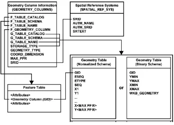
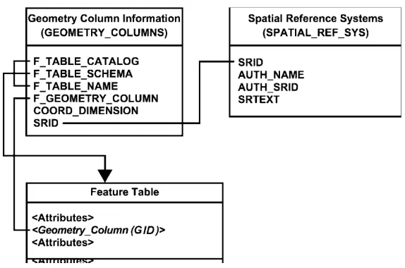
Figure 1 illustrates the schema to support feature tables, Geometry, and Spatial Reference Information in an SQL-implementation based on predefined data types.
a) The
GEOMETRY_COLUMNS
table describes the available feature tables and their Geometry properties. b) TheSPATIAL_REF_SYS
table describes the coordinate system and transformations for Geometry. c) TheFEATURE TABLE
stores a collection of features. A feature table‘s columns represent featureattributes, while rows represent individual features. The Geometry of a feature is one of its feature attributes; while logically a geometric data type, a Geometry Column is implemented as a foreign key to a geometry table.
Copyright © 2007 Open Geospatial Consortium, Inc. All Rights Reserved.
Figure 1: Schema for feature tables using predefined data types
Depending upon the storage type specified by the GEOMETRY_COLUMNS table, a geometric object is stored either as an array of coordinate values or as a single binary value. In the former case, predefined SQL numeric types are used for the coordinates and these numeric values are obtained from the geometry table until the geometric object has been fully reconstructed. In the latter case, the complete geometric object is obtained in the Well-known Binary Representation as a single value.
6.1.2 Identification of feature tables and geometry columns
Feature tables and Geometry columns are identified through the GEOMETRY_COLUMNS table. Each Geometry Column in the database has an entry in the GEOMETRY_COLUMNS table. The data stored for each geometry column consists of the following:
a) the identity of the feature table of which this Geometry Column is a member;
b) the name of the Geometry Column;
c) the spatial reference system ID (SRID) for the Geometry Column;
d) the type of Geometry for the Geometry column;
e) the coordinate dimension for the Geometry Column;
Copyright © 2007 Open Geospatial Consortium, Inc. All Rights Reserved. vii g) the information necessary to navigate the geometry table in the case of normalized geometry storage.
6.1.3 Identification of Spatial Reference Systems
Every Geometry Column and every geometric entity is associated with exactly one Spatial Reference System. The Spatial Reference System identifies the coordinate system for all geometric objects stored in the column, and gives meaning to the numeric coordinate values for any geometric object stored in the column. Examples of
commonly used Spatial Reference Systems include ―Latitude Longitude‖ and ―UTM Zone10‖.
The SPATIAL_REF_SYS table stores information on each Spatial Reference System in the database. The columns of this table are the Spatial Reference System Identifier (SRID), the Spatial Reference System Authority Name (AUTH_NAME), the Authority Specific Spatial Reference System Identifier (AUTH_SRID) and the Well-known Text description of the Spatial Reference System (SRTEXT). The Spatial Reference System Identifier (SRID) constitutes a unique integer key for a Spatial Reference System within a database.
Interoperability between clients is achieved via the SRTEXT column which stores the Well-known Text representation for a Spatial Reference System.
6.1.4 Feature tables
A feature is an abstraction of a real-world object. Feature attributes are columns in a feature table. Features are rows in a feature table. The Geometry of a feature is one of its feature attributes; while logically a geometric data type, a geometry column is implemented as a foreign key to a geometry table.
Relationships between features may be defined as foreign key references between feature tables.
6.1.5 Geometry tables
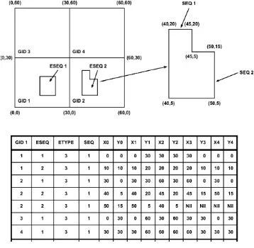
6.1.5.1 Normalized geometry schema
The normalized geometry schema stores the coordinates of geometric objects as predefined SQL numeric types. One or more coordinates (
X, Y
and optionallyZ
andM
ordinate values) will be represented by pairs of numeric types in the geometry table, as shown in Figure 2. Each geometric object is identified by a key (GID) and consists of one or more primitive elements ordered by an element sequence (ESEQ). Each primitive element in thegeometric object is distributed over one or more rows in the geometry table, identified by a primitive type (ETYPE), and ordered by a sequence number (SEQ).
The rules for geometric object representation in the normalized schema are defined as follows.
a) ETYPE designates the Geometry Type.
b) Geometric objects may have multiple elements. The ESEQ value identifies the individual elements.
c) An element may be built up from multiple parts (rows). The rows and their proper sequence are identified by the SEQ value.
d) Polygons may contain holes, as described in the Geometry object model.
Copyright © 2007 Open Geospatial Consortium, Inc. All Rights Reserved.
f) Coordinate pairs that are not used shall be set to Nil in complete sets (both X and Y). This is the only way to identify the end of the list of coordinates.
g) For geometric objects that continue onto an additional row (as defined by a constant element sequence number or ESEQ), the last Point of one row is equal to the first Point of the next.
h) There is no limit on the number of elements in the geometric object, or the number of rows in an element.
Figure 2: Example of geometry table for Polygon Geometry using SQL
6.1.5.2 Binary geometry schema
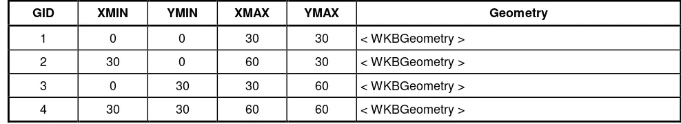
Copyright © 2007 Open Geospatial Consortium, Inc. All Rights Reserved. ix Table 1: Example of geometry table for Polygon Geometry
Using the Well-known Binary Representation for Geometry
GID XMIN YMIN XMAX YMAX Geometry
1 0 0 30 30 < WKBGeometry >
2 30 0 60 30 < WKBGeometry >
3 0 30 30 60 < WKBGeometry >
4 30 30 60 60 < WKBGeometry >
6.1.5.3 SQL/MM geometry schema
The geometric attributes of a feature may also be specified using an extension of SQL/MM
6.1.6 Text
6.1.6.1 ANNOTATIONS Metadata Table
Each feature table/geometry column pair that has associated annotation text entities will be represented as a row in the ANNOTATIONS metadata table, or view. The data stored for each for annotation is:
The identity of the feature table containing the text column
The column in the feature table that contains the text entity key for associating multiple text elements to a single text entity
A base scale for which the text placement is designed
Optionally, a geometry column in the feature table for associated geometry representing an envelop for the text
The identity of the text element table containing the geometry column
The column name in the text element table that contains the text to be placed
The column name in the text element table that contains the location geometry of the text
The column name in the text element table that contains the optional leader line that may be associated with the text.
The column name in the text element table that contains text rendering data
Default values for the text element, either by value of by using ―sql-value expressions‖ that can be evaluated on the feature entry associated to the text.
Copyright © 2007 Open Geospatial Consortium, Inc. All Rights Reserved.
The base scale for all size values that will be given in points1 (1 point = 0.35146 mm). Each text object has a font size from the style. To enable annotation text, a mechanism is needed whereby text may be defined in points but (usually) based on a specific map scale. Thus, a text object would be placed using a font size of 24 point at 1:1000000 and client-rendering engines would use this information to scale the text size appropriate to changes in the map scale. This base scale would be stored once in the metadata. Any point size values in the metadata attributes column (see below) or in individual rows would be relative to this value, as would letter-spacing and word-spacing, stroke-width (for text and leader line) and both vertical and horizontal margins. Application may round to the nearest point during scaling.
6.1.6.2 Table or View Constructs for structural metadata
The following CREATE TABLE statement creates an appropriately structured table to be included in the schema, describing how text is stored in a feature table. This should be either an actual metadata table or an updateable view so that insertion of reference system information can be done directly with SQL.
Note that there is no requirement that the annotated feature have any other attributes. Unattributed annotations are in essence context-free, and may be used to place any text on the data, such as collection metadata or notes to user about unusual situations of which he may wish to be aware.
Copyright © 2007 Open Geospatial Consortium, Inc. All Rights Reserved. xi
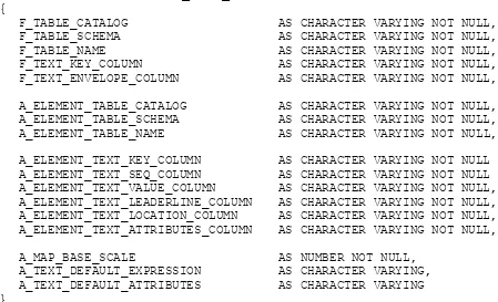
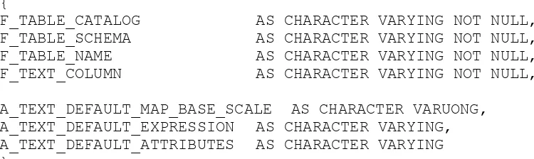
CREATE TABLE ANNOTATION_TEXT_METADATA AS
{
F_TABLE_CATALOG
AS CHARACTER VARYING NOT NULL,
F_TABLE_SCHEMA
AS CHARACTER VARYING NOT NULL,
F_TABLE_NAME
AS CHARACTER VARYING NOT NULL,
F_TEXT_KEY_COLUMN
AS CHARACTER VARYING NOT NULL,
F_TEXT_ENVELOPE_COLUMN
AS CHARACTER VARYING NOT NULL,
A_ELEMENT_TABLE_CATALOG
AS CHARACTER VARYING NOT NULL,
A_ELEMENT_TABLE_SCHEMA
AS CHARACTER VARYING NOT NULL,
A_ELEMENT_TABLE_NAME
AS CHARACTER VARYING NOT NULL,
A_ELEMENT_TEXT_KEY_COLUMN
AS CHARACTER VARYING NOT NULL
A_ELEMENT_TEXT_SEQ_COLUMN
AS CHARACTER VARYING NOT NULL
A_ELEMENT_TEXT_VALUE_COLUMN
AS CHARACTER VARYING NOT NULL,
A_ELEMENT_TEXT_LEADERLINE_COLUMN
AS CHARACTER VARYING NOT NULL,
A_ELEMENT_TEXT_LOCATION_COLUMN
AS CHARACTER VARYING NOT NULL,
A_ELEMENT_TEXT_ATTRIBUTES_COLUMN
AS CHARACTER VARYING NOT NULL,
A_MAP_BASE_SCALE
AS NUMBER NOT NULL,
A_TEXT_DEFAULT_EXPRESSION
AS CHARACTER VARYING,
A_TEXT_DEFAULT_ATTRIBUTES
AS CHARACTER VARYING
}
Note that there are no constraints on row in this table, allowing a single feature table/geometry column pair to be annotated using text from different feature table columns.
6.1.6.3 Field Description
The fields in the Annotations metadata information view are given in
Table 2: Column definitions for Annotation Text metadata
Columns Description
F_TABLE_
CATALOG,
SCHEMA,
NAME
the fully qualified name of the feature table containing the geometry column to be annotated
F_TEXT_
KEY_COLUMN.
ENVELOPE_CO
LUMN,
The names of the column in the feature table that contain:
Copyright © 2007 Open Geospatial Consortium, Inc. All Rights Reserved.
Columns Description
A_
ELEMENT_TABLE
CATALOG,
SCHEMA,
NAME
the fully qualified name of the text element table containing the text elements used for the
F_Text
columns column defined aboveA_TEXT_ELEMENT
The names of the columns in the ELEMENT_TABLE that contain the:
a)
The foreignKEY
for the text entity as specified in theF_TEXT_KEY_COLUMN.
b) A sequence (SEQ) column which will be used to order the text elements in this text entity. Any sortable type is valid for this column in the table, although integers would be the obvious choice.
c) A text string
VALUE
for this text element.d) The
LEADERLINE
for this text element if it has one (should also be a geometry column).e) The
LOCATION
for this text element (should also be a geometry column).f) The local text
ATTRIBUTES
providing the opportunity to override the text attributes currently in force. This is an XML type, and will be a collection of XML elements each describing a text attribute of the current text element. Unspecified attributes take the value most recently defined.A_MAP_BASE_SCALE
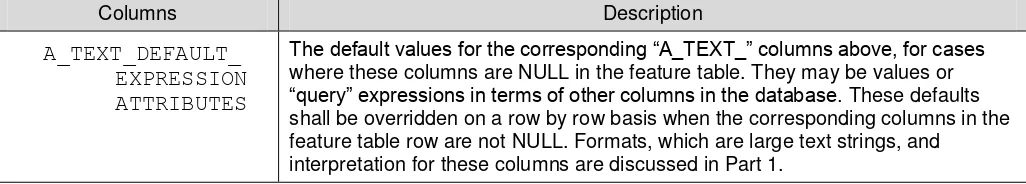
The base scale for all size values that will be given in points2 (1 point = 0.35146 mm).Copyright © 2007 Open Geospatial Consortium, Inc. All Rights Reserved. xiii
Columns Description
A_TEXT_DEFAULT_
EXPRESSION
ATTRIBUTES
The default values for the corresponding ―A_TEXT_‖ columns above, for cases
where these columns are NULL in the feature table. They may be values or
―query‖ expressions in terms of other columns in the database. These defaults shall be overridden on a row by row basis when the corresponding columns in the feature table row are not NULL. Formats, which are large text strings, and
interpretation for these columns are discussed in Part 1.
6.1.7 Use of numeric data types
SQL-implementations usually provide several numeric data types. In this standard, the use of a numeric data type in examples is not meant to be binding. The data type of any particular column can be determined, and casting operators between similar data types are available. Any particular implementation may use alternative data types as long as casting operations shall not lead to difficulties.
6.1.8 Notes on SQL/CLI access to Geometry values stored in binary form
SQL/CLI provides standard mechanisms to bind character, numeric and binary data values.
This subclause describes the process of retrieving geometric object values for the case where the binary storage alternative is chosen.
The WKB_GEOMETRY column in the geometry table is accessed in SQL/CLI as one of the binary SQL data types (SQL_BINARY, SQL_VARBINARY, or SQL_LONGVARBINARY).
EXAMPLE The application would use the SQL_C_BINARY value for the fCType parameter of SQLBindCol (or SQLGetData) in order to describe the application data buffer that shall receive the fetched Geometry data value. Similarly, a dynamic parameter whose value is a Geometry would be described using the SQL_C_BINARY value for the fCType parameter of SQLBindParameter.
This allows binary values to be both retrieved from and inserted into the geometry tables.
6.2 Architecture
—
SQL implementation using Geometry Types
6.2.1 Overview
This standard defines a schema for the management of feature table, Geometry, and Spatial Reference System information in an SQL-implementation with a Geometry Type extension.
Figure 3 illustrates the schema to support feature tables, Geometry, and Spatial Reference Information in an SQL-implementation with a Geometry Type extension.
a) The GEOMETRY_COLUMNS table describes the available feature tables and their Geometry properties.
Copyright © 2007 Open Geospatial Consortium, Inc. All Rights Reserved.
c) The feature table stores a collection of features. A feature table‘s columns represent feature attributes, while rows represent individual features. The Geometry of a feature is one of the feature attributes, and is an SQL Geometry Type.
Figure 3: Schema for feature tables using SQL with Geometry Types
6.2.2 Identification of feature tables and geometry columns
Feature tables and Geometry columns are identified through the GEOMETRY_COLUMNS table. Each Geometry Column in the database has an entry in the GEOMETRY_COLUMNS table. The data stored for each geometry column consists of the following:
a) the identity of the feature table of which this Geometry Column is a member;
b) the name of the Geometry Column;
c) the spatial reference system ID for the Geometry Column;
d) the coordinate dimension for the Geometry column;
The columns in the GEOMETRY_COLUMNS table for the SQL with Geometry Types environment are a subset of the columns in the GEOMETRY_COLUMNS table defined for the SQL-implementation based on predefined data types.
Copyright © 2007 Open Geospatial Consortium, Inc. All Rights Reserved. xv SQL INFORMATION_SCHEMA. To access this information, the GEOMETRY_COLUMNS table would still need to be referenced.
6.2.3 Identification of Spatial Reference Systems
Every Geometry Column is associated with a Spatial Reference System. The Spatial Reference System identifies the coordinate system for all geometric objects stored in the column, and gives meaning to the numeric coordinate values for any geometric object stored in the column. Examples of commonly used Spatial Reference Systems
include ―Latitude Longitude‖ and ―UTM Zone10‖.
The SPATIAL_REF_SYS table stores information on each Spatial Reference System in the database. The columns of this table are the Spatial Reference System Identifier (SRID), the Spatial Reference System Authority Name (AUTH_NAME), the Authority Specific Spatial Reference System Identifier (AUTH_SRID) and the Well-known Text description of the Spatial Reference System (SRTEXT). The Spatial Reference System Identifier (SRID) constitutes a unique integer key for a Spatial Reference System within a database.
Interoperability between clients is achieved via the SRTEXT column which stores the Well-known Text representation for a Spatial Reference System.
6.2.4 Feature tables
A feature is an abstraction of a real-world object. Feature attributes are columns in a feature table. Features are rows in a feature table. The Geometry of a feature is stored in a Geometry Column whose type is drawn from a set of SQL Geometry Types.
Relationships between features may be defined as foreign key references between feature tables.
6.2.5 Background information on SQL User Defined Types
The term User Defined Type (UDT) refers to a data type that extends the SQL type system.
UDT types can be used to define the column types for tables, this allows values stored in the columns of a table to be instances of UDT.
SQL functions may be declared to take UDT values as arguments, and return UDT values as results.
An UDT may be defined as a subtype of another UDT, referred to as its supertype. This allows an instance of the subtype to be stored in any column where an instance of the supertype is expected and allows an instance of the subtype to be used as an argument or return value in any SQL function that is declared to use the supertype as an argument or return value.
The above definition of UDT is value based.
SQL implementations that support User Defined Types may also support the concept of References to User Defined Types instances that are stored as rows in a table whose type corresponds to the type of the User Defined Type. The terms RowType and Reference to RowType are also used to describe such types.
Copyright © 2007 Open Geospatial Consortium, Inc. All Rights Reserved.
The Types for Geometry are defined in black-box terms, i.e. all access to information about a Geometry Type instance is through SQL functions. No attempt is made to distinguish functions that may access Type instance attributes (such as the dimension of a geometric object) from functions that may compute values given a Type instance (such as the centroid of a Polygon). In particular, an implementation of this standard would be free to nominate any set of functions as observer methods on attributes of a User Defined Type, as long as the signatures of the SQL functions described in this standard are preserved.
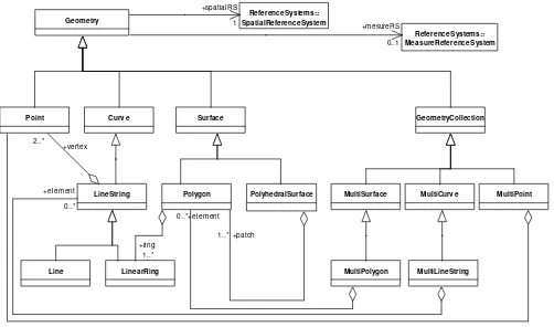
6.2.6 SQL Geometry Type hierarchy
The SQL Geometry Types are organized into a type hierarchy shown in Figure 4.
Geometry SpatialReferenceSystemReferenceSystems::
Point Curv e Surface GeometryCollection
MultiSurface MultiCurv e MultiPoint
MultiPolygon MultiLineString LineString
Line LinearRing
Polygon PolyhedralSurface
ReferenceSystems:: MeasureReferenceSystem +spatialRS
1
+mesureRS
0..1
+element 0..* +element
0..* +vertex 2..*
+ring 1..*
+patch 1..*
Figure 4: Figure: SQL Geometry Type hierarchy
The root type, named Geometry, has subtypes for Point, Curve, Surface and Geometry Collection. A Geometry Collection is a Geometry that is a collection of possibly heterogeneous geometric objects. MultiPoint, MultiCurve and MultiSurface are specific subtypes of Geometry Collection used to manage homogenous collections of Points, Curves and Surfaces. The 0 dimensional Geometry Types are Point and MultiPoint.
Copyright © 2007 Open Geospatial Consortium, Inc. All Rights Reserved. xvii SQL functions are defined to construct instances of the above Types given Well-known Text or Binary
representations of the types. SQL functions defined on the types implement the methods described in the Geometry Object Model.
6.2.7 Geometry values and spatial reference systems
In order to model Spatial Reference System information, each geometric object in the SQL with Geometry Types implementation is associated with a Spatial Reference System as specified by SQL/MM.
In addition to the SQL/MM
6.2.8 Access to Geometry values in the SQL with Geometry Type case
Spatial data are accessed using the SQL query language extended with SQL routines to create Geometry Types as well as routines to observe or mutate their attributes, as specified by SQL/MM..
6.2.9 Text
6.2.9.1 Text Object Implementation
6.2.9.1.1 Text Objects
The text object, and their component elements which can be used either as a feature attribute or as a free-floating object, is defined in 7.2.20.
6.2.9.2 Metadata Table (View)
The metadata at a table level allows common information to be stored at a common level and not for each record. This keep the data for each record as compact as possible. There is no specific specification for this metadata table. But the data requirements in Table 3 must be available from the metadata store. This data if created as a table would look like this:
CREATE TABLE ANNOTATION_TEXT_METADATA AS
{
F_TABLE_CATALOG
AS CHARACTER VARYING NOT NULL,
F_TABLE_SCHEMA
AS CHARACTER VARYING NOT NULL,
F_TABLE_NAME
AS CHARACTER VARYING NOT NULL,
F_TEXT_COLUMN
AS CHARACTER VARYING NOT NULL,
A_TEXT_DEFAULT_MAP_BASE_SCALE AS CHARACTER VARUONG,
A_TEXT_DEFAULT_EXPRESSION AS CHARACTER VARYING,
A_TEXT_DEFAULT_ATTRIBUTES AS CHARACTER VARYING
}
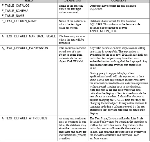
Copyright © 2007 Open Geospatial Consortium, Inc. All Rights Reserved. Table 3: Text metadata attributes
FIELD DEFINITION COMMENT
F_TABLE_CATALOG F_TABLE_SCHEMA F_TABLE_NAME
Name of the table in which the text type values are stored.
Databases have format for this based on SQL:1999.
F_TEXT_COLUMN_NAME Name of the column in which the text type value are stored.
Databases have format for this based on SQL:1999. This column in the feature table described above must be of type
ANNOTATION_TEXT. A_TEXT_DEFAULT_MAP_BASE_SCALE The base map scale for
which the text will be displayed
A_TEXT_DEFAULT_EXPRESSION This column allows the actual text of a text object to come from data outside the text object VALUE field.
Any valid database column expression resulting in a string is acceptable. The expression is evaluated for the each row. If this field is null, the individual text objects may have their own embedded text or nothing shall be displayed. Any embedded text shall override this expression value.
During query to support display, client applications should add this expression to their select list so that any returned records will have the information needed to evaluate this expression without round tripping back to the database. . Note that this is the one case where the data critical to the display of text is stored outside the text object or metadata. It should be obvious to anyone changing the VALUE field that they are changing the text object. It may not be obvious to someone updating a column covered by the text expression that they are affecting the text object display.
A_TEXT_DEFAULT_ATTRIBUTES As many text attributes may be common in one table, the database may store the common ones once here and allow for individual row (record) overrides.
Copyright © 2007 Open Geospatial Consortium, Inc. All Rights Reserved. xix
7 Clause component specifications
7.1 Components
—
Implementation of feature tables based on predefined data types
7.1.1 Conventions
Table components are described in the context of a CREATE TABLE statement. Implementations may use base tables with different names and properties, exposing these components as updateable views, provided that the base tables defined by the implementation enforce the same constraints.
Table names and column names have been restricted to 18 characters in length to allow for the widest possible implementation.
7.1.2 Spatial reference system information
7.1.2.1 Component overview
The Spatial Reference Systems table, which is named SPATIAL_REF_SYS, stores information on each spatial reference system used in the database.
7.1.2.2 Table constructs
The following CREATE TABLE statement creates an appropriately structured SPATIAL_REF_SYS table. This table may be an updatable view of an implementation-specific table. Implementations shall either use this table format or provide stored procedures to create, to populate and to maintain this table
CREATE TABLE SPATIAL_REF_SYS
(
SRID
INTEGER NOT NULL PRIMARY
KEY,
AUTH_NAME
CHARACTER VARYING,
AUTH_SRID
INTEGER,
SRTEXT
CHARACTER VARYING(2048)
)
7.1.2.3 Field description
These fields are described as follows:
a) SRID — an integer value that uniquely identifies each Spatial Reference System within a
database;
Copyright © 2007 Open Geospatial Consortium, Inc. All Rights Reserved.
c) AUTH_SRID — the ID of the Spatial Reference System as defined by the Authority cited in AUTH_NAME;
d) SRTEXT — The Well-known Text Representation of the Spatial Reference System.
7.1.2.4 Exceptions, errors and error codes
Error handling shall be accomplished by using the standard SQL status returns.
7.1.3 Geometry columns information
7.1.3.1 Component overview
Copyright © 2007 Open Geospatial Consortium, Inc. All Rights Reserved. xxi 7.1.3.2 Table or view constructs
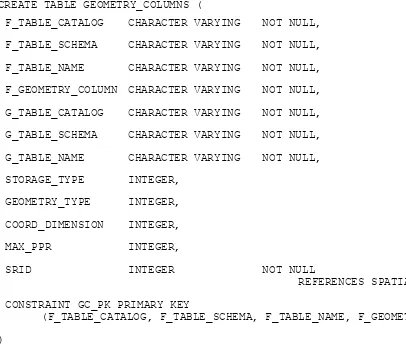
CREATE TABLE GEOMETRY_COLUMNS (
F_TABLE_CATALOG
CHARACTER VARYING
NOT NULL,
F_TABLE_SCHEMA
CHARACTER VARYING
NOT NULL,
F_TABLE_NAME
CHARACTER VARYING
NOT NULL,
F_GEOMETRY_COLUMN CHARACTER VARYING
NOT NULL,
G_TABLE_CATALOG
CHARACTER VARYING
NOT NULL,
G_TABLE_SCHEMA
CHARACTER VARYING
NOT NULL,
G_TABLE_NAME
CHARACTER VARYING
NOT NULL,
STORAGE_TYPE
INTEGER,
GEOMETRY_TYPE
INTEGER,
COORD_DIMENSION
INTEGER,
MAX_PPR
INTEGER,
SRID
INTEGER
NOT NULL
REFERENCES SPATIAL_REF_SYS,
CONSTRAINT GC_PK PRIMARY KEY
(F_TABLE_CATALOG, F_TABLE_SCHEMA, F_TABLE_NAME, F_GEOMETRY_COLUMN)
)
7.1.3.3 Field description
These fields are described as follows:
a) F_TABLE_CATALOG, F_TABLE_SCHEMA, F_TABLE_NAME— the fully qualified name of the feature table containing the geometry column.
b) F_GEOMETRY_COLUMN— the name of the column in the feature table that is the Geometry Column. This column shall contain a foreign key reference into the geometry table for an implementation based on predefined data types. For a geometry types implementation, this column may contain either a foreign key to a geometry extent table or a SQL UDT.
c) G_TABLE_CATALOG, G_TABLE_SCHEMA, G_TABLE_NAME— the name of the geometry table and its schema and catalog. The geometry table implements the geometry column. In a geometry types implementation that stores the geometry in the F_GEOMETRY_COLUMN, these columns will be identical to the F_TABLE_CATALOG, F_TABLE_SCHEMA, F_TABLE_NAME column values.
Copyright © 2007 Open Geospatial Consortium, Inc. All Rights Reserved. 0 = normalized geometry implementation,
1 = binary geometry implementation (Well-known Binary Representation for Geometry).
NULL = geometry types implementation,
e) GEOMETRY_TYPE— the type of geometry values stored in this column. The use of a non-leaf Geometry class name from the Geometry Object Model for a geometry column implies that domain of the column corresponds to instances of the class and all of its subclasses. The suffixes "Z", "M" and "ZM" are three distinct copies of the geometry hierarchy as presented in Figure 4. If the value is NULL, then the appropriate GEOMETRY subtype is used consistent with the COORD_DIMENSION and SRID is implied. This code list is a subset of the list presented in Part 1, Table 7.
Table 4: Geometry type codes
Code
Geometry type
Coordinates
0
GEOMETRY
\\ IN X Y
1
POINT
\\ IN X Y
2
LINESTRING
\\ IN X Y
3
POLYGON
\\ IN X Y
4
MULTIPOINT
\\ IN X Y
5
MULTILINESTRING
\\ IN X Y
6
MULTIPOLYGON
\\ IN X Y
7
GEOMCOLLECTION
\\ IN X Y
13
CURVE
\\ IN X Y
14
SURFACE
\\ IN X Y
15
POLYHEDRALSURFACE
\\ IN X Y
1000
GEOMETRYZ
\\ IN X Y Z
1001
POINTZ
\\ IN X Y Z
Copyright © 2007 Open Geospatial Consortium, Inc. All Rights Reserved. xxiii
Code
Geometry type
Coordinates
1003
POLYGONZ
\\ IN X Y Z
1004
MULTIPOINTZ
\\ IN X Y Z
1005
MULTILINESTRINGZ
\\ IN X Y Z
1006
MULTIPOLYGONZ
\\ IN X Y Z
1007
GEOMCOLLECTIONZ
\\ IN X Y Z
1013
CURVEZ
\\ IN X Y M
1014
SURFACEZ
\\ IN X Y M
1015 POLYHEDRALSURFACEZ
\\ IN X Y Z
2000
GEOMETRY
\\ IN X Y M
2001
POINTM
\\ IN X Y M
2002
LINESTRINGM
\\ IN X Y M
2003
POLYGONM
\\ IN X Y M
2004
MULTIPOINTM
\\ IN X Y M
2005
MULTILINESTRINGM
\\ IN X Y M
2006
MULTIPOLYGONM
\\ IN X Y M
2007
GEOMCOLLECTIONM
\\ IN X Y M
2013
CURVEM
\\ IN X Y M
2014
SURFACEM
\\ IN X Y M
2015 POLYHEDRALSURFACEM
\\ IN X Y M
3000
GEOMETRYZM
\\ IN X Y Z M
3001
POINTZM
\\ IN X Y Z M
Copyright © 2007 Open Geospatial Consortium, Inc. All Rights Reserved.
Code
Geometry type
Coordinates
3003
POLYGONZM
\\ IN X Y Z M
3004
MULTIPOINTZM
\\ IN X Y Z M
3005 MULTILINESTRINGZM \\ IN X Y Z M
3006
MultiPolygonZM
\\ IN X Y Z M
3007
GEOMCOLLECTIONZM
\\ IN X Y Z M
3013
CURVEZM
\\ IN X Y Z M
3014
SURFACEZM
\\ IN X Y Z M
3015 POLYHEDRALSURFACEZM \\ IN X Y Z M
f) COORD_DIMENSION— the number of ordinates used in the complex, usually corresponds to the number of dimensions in the spatial reference system. If an "M" ordinate is included it shall be one greater than the number of dimensions of the spatial reference system.
g) MAX_PPR— (This value contains data for the normalized geometry implementation only) Points per row, the number of Points stored as ordinate columns in the geometry table. This value may be NULL only if a binary storage or SQL geometry type implementation is used.
h) SRID— the ID of the Spatial Reference System used for the coordinate geometry in this table. It is a foreign key reference to the SPATIAL_REF_SYS table and must be specified.
7.1.3.4 Exceptions, errors and error codes
Error handling shall be accomplished by using the standard SQL status returns for SQL/CLI.
7.1.4 Feature tables
The columns in a feature table are defined by feature attributes; one or more of the feature attributes will be a geometric attribute. The basic restriction in this standard for feature tables is that for each geometric attribute, they include geometry via a FOREIGN KEY to a geometry table. Features may have a feature attribute that is unique, serving as a PRIMARY KEY for the feature table. Feature-to-feature relations may similarly be defined as
Copyright © 2007 Open Geospatial Consortium, Inc. All Rights Reserved. xxv The general format of a feature table shall be as follows:
CREATE TABLE <feature table name> (
<primary key column name> <primary key column type>,
…
(other attributes for this feature table)
<geometry column name> <geometry column type>,
…
(other geometry columns for this feature table)
PRIMARY KEY <primary key column name>,
FOREIGN KEY <geometry column name> REFERENCES <geometry table name>,
…
(other geometry column constraints for this feature table)
)
The geometric attribute foreign key reference applies only for the case where the geometry table stores geometry in binary form. In the case where geometry is stored in normalized form, there may be multiple rows in the geometry table corresponding to a single geometry value. In this case, the geometry attribute reference may be captured by a check constraint that ensures that the Geometry Column value in the feature table corresponds to the geometry-ID value for one or more rows in the geometry table.
7.1.5 Geometry tables
7.1.5.1 Component overview
Each Geometry table stores geometric objects corresponding to a Geometry column in a feature table. Geometric objects may be stored as individual ordinate values, using SQL numeric types, or as binary objects, using the Well-known Binary Representation for Geometry. Table schemas for both implementations are provided.
7.1.5.2 Geometry stored using SQL numeric types
7.1.5.2.1 Table constructs
Copyright © 2007 Open Geospatial Consortium, Inc. All Rights Reserved.
CREATE TABLE <table name>
(
GID
INTEGER NOT NULL,
ESEQ
INTEGER NOT NULL,
ETYPE
INTEGER NOT NULL,
SEQ
INTEGER NOT NULL,
X1
<ordinate type>,
Y1
<ordinate type>,
Z1
<ordinate type>,
!Optional if Z-value is included
M1
<ordinate type>,
!Optional if M-value is included
... <repeated for each ordinate, repeated for each point>
X<MAX_PPR>
<ordinate type>,
Y<MAX_PPR>
<ordinate type>,
Z1<MAX_PPR>
<ordinate type>,
!Optional if Z-value is included
M1<MAX_PPR>
<ordinate type>,
!Optional if M-value is included
...,
<attribute>
<attribute type>
CONSTRAINT GID_PK PRIMARY KEY (GID, ESEQ, SEQ)
)
7.1.5.2.2 Field descriptions
These field descriptions are follows:
a.
GID —
identity of this geometric object;Copyright © 2007 Open Geospatial Consortium, Inc. All Rights Reserved. xxvii c.
ETYPE
— element type of this primitive element for the geometric object. The following values are definedfor ETYPE:
1 Point,
2 LineString,
3 Polygon;
d.
SEQ
— identifies the sequence of rows to define a geometric object;e.
X1
— first ordinate of first Point;f.
Y1
— second ordinate of first Point;g.
Z1
— third ordinate of first Point;h.
M1 —
fourth ordinate of first Point;i. ...— (repeated for each ordinate, for this Point);
j. ... — (repeated for each coordinate, for this row);
k.
X<MAX_PPR>
— first ordinate of last Point. The maximum number of Points per row ‗MAX_PPR' is consistent with the information in the GEOMETRY_COLUMNS table;l.
Y<MAX_PPR> —
second ordinate of last Point;m. .
Z<MAX_PPR>
— third ordinate of first Point;n.
M<MAX_PPR>
fourth ordinate of first Point;o. .. — (repeated for each ordinate, for this last Point);
p.
<attribute>
— other attributes can be carried in the Geometry table for specific feature schema.7.1.5.2.3 Exceptions, errors and error codes
Error handling shall use the standard SQL status returns for SQL/CLI.
7.1.5.3 Geometry stored using SQL binary types
7.1.5.3.1 Table constructs
Copyright © 2007 Open Geospatial Consortium, Inc. All Rights Reserved.
implementation. Implementations shall either use this table format or provide stored procedures to create, populate and maintain this table.
CREATE TABLE <table name>
(
GID
NUMERIC
NOT NULL PRIMARY KEY,
XMIN
<ordinate type>,
YMIN
<ordinate type>,
ZMIN
<ordinate type>,
MMIN
<ordinate type>,
XMAX
<ordinate type>,
YMAX
<ordinate type>,
ZMAX
<ordinate type>,
MMAX
<ordinate type>,
WKB_GEOMETRY BIT VARYING(implementation size limit),
{<attribute> <attribute type>}*
)
7.1.5.3.2 Field descriptions
These fields are described as follows:
a.
GID
— identity of this geometric object;b.
XMIN
— the minimum x-coordinate of the geometric object bounding box;c.
YMIN
— the minimum y-coordinate of the geometric object bounding box;d.
ZMIN
— the maximum y-coordinate of the geometric object bounding box;e.
MMIN
— the maximum y-coordinate of the geometric object bounding box;f.
XMAX
— the maximum x-coordinate of the geometric object bounding box;g.
YMAX
— the maximum y-coordinate of the geometric object bounding box;h.
ZMAX
— the maximum y-coordinate of the geometric object bounding box;i.
MMAX
— the maximum y-coordinate of the geometric object bounding box;j.
WKB_GEOMETRY
— the Well-known Binary Representation of the geometric object;Copyright © 2007 Open Geospatial Consortium, Inc. All Rights Reserved. xxix 7.1.5.3.3 Exceptions, errors and error codes
Error handling shall use the standard SQL status returns for SQL/CLI.
7.1.6 Operators
No SQL spatial operators are defined as part of this standard.
7.2 Components
—
SQL with Geometry Types implementation of feature tables
7.2.1 Conventions
The components of this standard for feature table implementation in a SQL with Geometry Types environment consist of the tables, SQL types and SQL functions discussed in 7.2 with routines as specified by SQL/MM.
7.2.2 SQL Geometry Types
7.2.2.1 Component overview
The SQL Geometry Types extend the set of available predefined data types to include Geometry Types.
7.2.2.2 Language constructs
A conforming implementation shall support a subset of the following set of SQL Geometry Types: {
Geometry,
Point, Curve, LineString, Surface, Polygon, PolyhedralSurface
GeomCollection, MultiCurve, MultiLineString, MultiSurface,
MultiPolygon,
andMultiPoint
}. The permissible type subsets that an implementer may choose to implement are described in SQL/MM.Note: Class names in SQL/MM carry a "ST_" prefix. This is optional and implementations may chose to drop this prefix as has been done in various places in this standard.
The new type listed above is
PolyhedralSurface
shall be subtyped fromSurface,
and implements the required constructors, routines and interfaces ofSurface
andMultiSurface.
To maintain a size limit on class names, the class name in SQL forPolyhedralSurface
will bePolyhedSurface
.7.2.3 Feature tables
7.2.3.1 Component overview
Copyright © 2007 Open Geospatial Consortium, Inc. All Rights Reserved.
attribute that is unique, serving as a
PRIMARY KEY
for the feature table. Feature-to-feature relations may be defined asFOREIGN KEY
references where appropriate.7.2.3.2 Table constructs
The general format of a feature table in the SQL with Geometry Types implementation shall be as follows:
CREATE TABLE <feature table name> (
<primary key column name> <primary key column type>,
…
(other attributes for this feature table)
<geometry column name> <geometry type>,
…
(other geometry columns for this feature table)
PRIMARY KEY <primary key column name>,
CONSTRAINT SRS_1 CHECK (SRID(<geometry column name>)
in (
SELECT SRID from GEOMETRY_COLUMNS
where F_TABLE_CATALOG = <catalog> and
F_TABLE_SCHEMA = <schema> and
F_TABLE_NAME = <feature table name> and
F_GEOMETRY_COLUMN = <geometry column>
)
… ( spatial reference constraints for other geometry columns
in this feature table)
)
The use of any SQL Geometry Type for any of the columns in the table identifies this table as a feature table. Alternatively, applications may check the GEOMETRY_COLUMNS table, where all Geometry Columns and their associated feature tables and geometry tables are listed.
7.2.3.3 Exceptions, errors and error codes
Error handling shall be accomplished by using the standard SQL status returns.
7.2.4 SQL routines for constructing a geometry object given its Well-known Text Representation
The routines ST_WKTToSQL used to construct geometric objects from their text representations are specified by SQL/MM..
7.2.5 SQL routines for constructing a geometric object given its Well-known Binary Representation
Copyright © 2007 Open Geospatial Consortium, Inc. All Rights Reserved. xxxi 7.2.6 SQL routines for obtaining Well-known Text Representation of a geometric object
The SQL routines ST_AsText for obtaining the Well-known Text Representation of a geometric object are specified in SQL/MM.
7.2.7 SQL routines for obtaining Well-known Binary Representations of a geometric object
The SQL routines ST_AsBinary for obtaining the Well-known Binary Representation of a geometric object are specified in SQL/MM.
7.2.8 SQL routines on type Geometry
7.2.8.1 Supported routines
The SQL/MM
ST_Dimension, ST_GeometryType, ST_AsText, ST_AsBinary,
ST_SRID, ST_IsEmpty, ST_IsSimple, ST_Boundary
, andST_Envelope
routines shall be supported for all Geometry Types. Also included are SQL routines for obtaining the Well-known Binary and Text Representation of a geometric object and creating values from them.Consistent with the definitions of relations in Part 1, Clause 6.1.2.3, the SQL/MM
ST_Equals,
ST_Disjoint,
ST_Intersects
, ST_Touches, ST_Crosses, ST_Within,
ST_Contains, ST_Overlaps
andST_Relate
routines shall be supported to test named spatial relationships between two geometric objects.The SQL/MM
ST_Distance
routines shall be supported to calculate the distance between two geometric objects.Consistent with the set theoretic operations defined in ISO 19103, and ISO 19107, the SQL/MM
ST_Intersection, ST_Difference, ST_Union, ST_SymDifference, ST_Buffer,
and
ST_ConvexHull
routines shall be supported to implement set-theoretic and constructive operations on geometric objects. These operations are defined for all types of Geometry.7.2.8.2 Declarations from SQL/MM (informative)
CREATE TYPE ST_Geometry
AS (
ST_PrivateDimension
SMALLINT DEFAULT
-1,
ST_PrivateCoordinateDimension
SMALLINT DEFAULT
2,
ST_PrivateIs3D
SMALLINT DEFAULT
0,
ST_PrivateIsMeasured
SMALLINT DEFAULT
0
)
Copyright © 2007 Open Geospatial Consortium, Inc. All Rights Reserved.