XSTREAM: A Highly Efficient High Speed Real-time Satellite Data Acquisition and
Processing System using Heterogeneous Computing
Pramod Kumar Ka, Mahendra Pa, Ramakrishna Reddy Va, Tirupathi Ta, AkilanAa, Usha Devi Ra, Anuradha Ra, Ravi Na,S.S.Solankia, AcharyKKb, AL Sateeshab and AnshuChauhanb
a
Advanced Data Processing Research Institute (ADRIN), Department Of Space, Govt. of India,203-Akbar Road, Manovikas Nagar Secunderabad-500009 - (pramod,mahendra, rkreddy, tiru, akilan, usha,anuradha, nooka.ravi, solanki)@adrin.res.in b
ISRO Satellite Center (ISAC), Indian Space Research Organization, Dept. of Space, Govt. of India, Old Airport Road,Bangalore-17 - (kkachary, alsatish, anshu)@isac.gov.in
KEY WORDS: Heterogeneous computing, Hybrid Computing, Satellite Data Processing, Real-time Processing, IRS Cartosat, GP/GPU, FPGA, OpenCL
ABSTRACT:
In the last decade, the remote sensing community has observed a significant growth in number of satellites, sensors and their resolutions, thereby increasing the volume of data to be processed each day. Satellite data processing is a complex and time consuming activity. It consists of various tasks, such as decode, decrypt, decompress, radiometric normalization, stagger corrections, ephemeris data processing for geometric corrections etc., and finally writing of the product in the form of an image file. Each task in the processing chain is sequential in nature and has different computing needs. Conventionally the processes are cascaded in a well organized workflow to produce the data products, which are executed on general purpose high-end servers / workstations in an offline mode. Hence, these systems are considered to be ineffective for real-time applications that require quick response and just-in-time decision making such as disaster management, home land security and so on..
This paper discusses anovel approach to processthe data online (as the data is being acquired) using a heterogeneous computing platform namely XSTREAM which has COTS hardware of CPUs, GPUs and FPGA. This paper focuses on the process architecture, re-engineering aspects and mapping of tasks to the right computing devicewithin the XSTREAM system, which makes it an ideal cost-effective platform for acquiring, processing satellite payload data in real-time and displaying the products in original resolution for quick response. The system has been tested for IRS CARTOSAT and RESOURCESAT series of satellites which have maximum data downlink speed of 210Mbps.
1. INTRODUCTION
Remote Sensing (RS) community has observed a significant growth in number of satellites, sensors and their resolutions, thus causing an exponential growth in the volume of data to for processing each day during last decade. On the other hand there has also been a growing demand to cut down the lead time for generating the products that need to be used by different applications, such as disaster management, home land security, etc. that demand quick response; therefore the data products need to be made available for these applications in the quickest possible time. Conventional data processing [1][2]that involves chains, though well proven, time tested and rugged, are considered to be ineffective for real-time applications that require quick response and just-in-time decision making. The examples of processing includes Decoding, Decryption, Decompression, Radiometric Normalization, Geo-coordinate computation and tagging the corner coordinates, and finally writing of the product onto the disk to make a Level-1A product. Additionally, for some of the missions such as Cartosat series of satellites, stagger estimation and stagger correction are also done before writing of the product onto the disk.
IRS Satellites such as IRS Cartosat-1[3],Cartosat-2[4], Resourcesat[5] capture images of ground and transmit the image data (also referred to as video data) after performing various on-board processing such as compression, encryption, error correction coding etc. Along with the image data, data pertaining to various sensors on-board, such as Star Sensor, Gyros, clock, health parameters etc., which are referred to as auxiliary data (ephemeris data or AUX data ) are also multiplexed with video data and transmitted to ground stations.
Video data is processed to produce viewable image, while aux data is used to estimate and tag the geo-location of the ground features in the final image product. The data is transmitted in the form of fixed frames by attaching a pattern called Frame Sequence Code (FSC) to identify the valid data on ground. Ground systems, acquire the data and process the payload data (video and aux) to generate level-1A product [6]. Cartosat-1 has two streams with each stream having I& Q channels of 52.5Mbps data rate, while Cartosat-2 downlinks the data in one stream having I & Q channels of 52.5Mbps each. The data is transmitted using X-band Carrier Radio Frequency (RF) communication system. The data is sent using X-band Carrier Radio Frequency (RF) communication system. RF data receiving and conversion to Intermediate Frequency (IF) at the ground stations etc., are standard equipments and are always done in real-time hence are not discussed in this paper.
Satellite payload data processing, to generate level-1A product from raw signal data received from the De-mod output, involves certain complex processes performed sequentially in the reverse order of on-board processing. The processes are similar to that of for most of the remote sensing satellites, with variation in mission specific formats and processes. For example, some missions do not compress or encrypt the data and similarly a different method may be adopted for encoding, encryption, or compression.
Figure-1 explains the conventional ground system data acquisition and processing for IRS Cartosat-1[1]and similar methodology is also adopted for Carosat-2 with mission specific variations. The system employs organized workflow to produce the usable data products, which are executed on general purpose high-end server(s)or workstation(s) in an offline mode (i.e., The International Archives of the Photogrammetry, Remote Sensing and Spatial Information Sciences, Volume XL-8, 2014
record the data to files, process them by rea the files and writing them back on to the disk).Therefore they consume a lot of resources and are deemed to be sub-optimal applications that demand quick response.
Figure 1. Ground System Processing to ge Product for IRS Cartosat-1
In the recent past, the computing paradigm shift from usual sequential processing to architectures duetothe clock speeds hitting th the major processor vendors manufacture wi in a single CPU. GP/GPU (General Processing Unit) is the latest addition in the Computing (HPC) domain. GPU is an acce contains very large number of cores, speci perform Single Instruction Multiple Data operations. Similarly, Field Programmable G are special electronic chips containing larg and Common Logic Blocks (CLB) which can behave like an electronic circuit, thus can performance by consuming less powe Processors (DSPs) which are inherently designed for specific processesand perform fast.
On the other hand there has also been a sig standardization of interfaces and progr Interfaces. PCIe[7] has emerged as de-facto of the add-on accelerator cards, FPGA c cards. OpenCL[8] and OpenMP[9] have em programming interface which support architectures and are vendor neutral. All t have given system engineers greater flexi right platform for a given task and integrate system, single instance of OS and a single pr
Heterogeneous computing or sometimes a Hybrid Computing [10] platforms integrate platforms such as CPUs, FPGAs and GPUs which can perform complex tasks/workflo achieve higher throughput.
[11]demonstrated the usage of Metacomp multiple resources and high speed netw processing and visualization of existing remo the process does not address the real-time pa discusses a requirement of storing the real-real-time database using file buffers. It
reading the data from the files on the hard of time, computing al and ineffective for
generate Level-1A 1/2
m has taken a radical to parallel/multi-core g the limits. Today, all with around ten cores l Purpose Graphics the High Performance ccelerator card which ecifically designed to ata (SIMD) type of e Gate Arrays (FPGA) arge number of Gates can be programmed to an achieve very high ll these developments exibility to chose the ate them into a single program.
s also referred to as ate various computing s into a single system flows in parallel and
mputing by utilizing etwork for real-time mote sensing data, but pass acquisition. [12] -time data into non-It does not discuss
elements of payload data processin use of Heterogeneous Computing u high throughput for different doma
This paper discusses a novel processing Remote Sensing Data being received) using a heterog namely XSTREAM having a comb FPGA.
Section 2 discusses the methodol aspects, mapping of the tasks to th synchronization of all the modules products and display them in orig (while the pass is being acquired discusses the test results and comp data processing chain in terms of qu 4 discusses the conclusion and futu
2. METHOD
2.1 Level-1A product generation
Figure 1 depicts the sequence of generation of level-1A product (als for any analysis) from raw signal d nature of the problem is listed be staggered placement of the CCD odd and even pixels are recorded, p and sent as I & Q channels. Hence to be performed for two streams (ix))and finally combined to gener (x) to step (xiii)).
i. Detection of Valid Frame search for frame header i. valid frames.
ii. Time Stamping: Time stamp Reception Time (GRT), wh Translator (TCT)
iii. Aux Separation:Separate th data and process aux data an iv. Decode:Decoding is done,
encoding.In Cartosatmissio Solomonencoding method byte errors in 247 bytes. v. Decrypt: Decrypt the dat
methodology used in the used is stream cipher and th of this paper.
vi. Decompress: Most of the use lossy compression tec downlink rates vis-a-vis d compressions are data dep length bit stream after c JPEG2000 etc). In Car compression,augmented wi and Huffman coding is u searching of header, follo stream, de-quantization and vii. Aux Processing: The star board time etc (also know used to construct orbit and with respect to the imagin computing the geo-location known as lat/longs) and tag computed lat/longs.
sing. [13][14] demonstrated the g using GP/GPUs for achieving mains.
approach of acquiring and ta in real-time (as the data is ogeneous computing platform mbination of CPUs, GPUs and
dology adopted, re-engineering the right computing device and lesin order to generate the data original resolution in real time ired and processed). Section 3 mparison with the conventional f quality and accuracies. Section uture directions.
DOLOGY
ion process:
of steps to be performed for also referred to as basic product l data and a brief description of below. Please note that due to D arrays in Cartosat missions, d, processed in separate streams ce the following processes need ms separately (step (i) to step nerate a level-1A product ((step
mes: Read the bit stream and r i.e., FSC code and store the
mp each frame with the Ground which is read from Time Code
the Aux data from the video a and video data independently.
e, which is a reverse process of sions standard 255/247
is used, which can correct
4-data based on the encryption ependent and produce variable compression (JPEG, DPCM, Cartosat series,JPEG[16] like with a rate control algorithm
nd attitude information (OAT) ging time. These are used in ion (latitude and longitude also tagging the image line with the The International Archives of the Photogrammetry, Remote Sensing and Spatial Information Sciences, Volume XL-8, 2014
viii. Stagger Estimation: Stagger value is specific to missions having staggered placement of CCD arrays like Cartosat satellites. The stagger value depends on the satellite look direction (Roll bias), and hence it changes for each scene. This requires complex geo-processing using OAT values.
ix. Radiometric normalization:Due to the non-linear nature of CCD devices, a gray level normalization process is to be performed. Often this process involves passing through a LookUp Table (LUT) for every pixel. LUT is pre-computed table based on lab settings, and is also routinely updated using a calibration test site.
For steps (i)-(ix), the data is processed in two independent streams I & Q in parallel, which have odd and even images separately without attaching the geo co-ordinates to the data. Further processeslisted through steps (x)-(xiii) are performed to combine and align the data to generate the basic level-1A product.
x. I&Q channel alignment: Since the data is processed from two independent chains there is a possibility of data mis-alignment due to any reasons, such as, loss of frames, bit-errors,process exception in one of the channels I/Q etc. Hence the data from both I & Q channels are to be aligned using the time tag and line count extractedfrom the video data.
xi. Stagger Correction: As explained in step-(viii), due to staggered placement of odd pixels and even pixels in the focal plane one of the images need to be shifted (resample) by a value computed in step (viii) to generate a stagger freefull swath original resolution image. xii. Strip Separation and Geo Tagging:For missions like
Cartosat-2 (which involves manoeuvring between two successive spot acquisitions) the data may contain manoeuvre data during of RT acquisition and in case of PB the strips are streamed continuously without any manoeuvre data. Hence the process involves separating the scenes and writing the separatedstrips as independent images. Aux processed values OAT is processed and stored as Auxiliary Data Interchange Format (ADIF) and are used to compute the geo-coordinates of the scene. The Geo-coordinatesat regular intervals and are stored in a separate file (grd file) and is used in subsequent processing, such as level-2 processing andlat/long readout in display process etc.
xiii. Geo-Image generation:The image thus generated in step (xi) and geo coordinates computed at regular intervals in step (xii) are combined together and written in a native format as a level-1A product (the design is flexible and can be written in any other open format like HDF5[15]).
2.2 Analysis& Design:
This section discusses the nature of processing involved for each of the task/step mentioned in section 2.1 and provides the reasoning for mapping them to the chosen device. Summary of the same is shown in Table 1.
The de-mod provides digital data to the system.The satellite transmission starts slightlyahead of the actual imaging data transmission.Hence to detect valid data a fixed code i.e., FSC is attached to every valid frame. The FSC code needs to be searched, for obtaining the valid data in the ground processing systems. Time stamping on each frame is also required to detect the frame losses during the transmission (if any) and replace them with interpolated values if possible. Since the nature of these tasks is search and replace in the bit stream obtained from
de-mod, it is ideal to perform these tasks on an FPGA. Hence a COTS FPGA based card is used which takes the Low Voltage Differential Signal (LVDS) input data and writes the valid frames onto main memory of the system. The card sits on a PCI-X bus and also provides a logic to stamp the time through IRIG-B interface,which can be used to correct the frame losses, wherever possible.
In Cartosat series of missions, the aux data is added to video data by the data formatter on-board. Hence the aux data in each valid frame needs to be separated from video data. Aux separationinvolvesextraction of fixed number of bytes from valid frame andcan be easily done on FPGA as well as on CPU. In some of the missions aux data is also encoded. Hence to make the process generic and flexible,the aux separation task is mapped to CPU in the proposed method.
The next step in the process chain is Decoding. RS-Encoding[17] is a common procedure adopted in satellite communications for correcting communication bit errors.RS-Encoding is a fixed block 255/247 encoding, the decoding process is iterative in nature and also to balance the load the on GPU and CPU, CPU implementation is chosen using multiple threads mapped to multi-core.
After decoding process, the next step is decryption. In Cartosat series of satellites stream cipher encryption is used. Decryption of stream cipher text involves simple XOR operations, which can be done on FPGA or GPU. Since the data is already available in the main memory of the host, noting that the process is a light weight process,further the next step needs to be done on CPU, the task is mapped to CPU to avoid multiple data transfers.
As explained in previous section that the compression results in a variable length code, a marker is attached to every compressed block. The decompression process involves searching of marker on CPU, and sent to GPU. Additionally, to address frame loss or irrecoverable errors in one of the channels (I or Q) the blocks are aligned and sent to GPU for decompression. The decompression is executed in block parallel way on GPU which is more optimal than that of CPU.
Aux processing involves complex modelling,which uses the ephemeris (AUX data), and iterative computations. This process is independent of video processing, hence, can easily be spawned as a separate dedicated thread on CPU. This module also performs stagger estimation and identifies the strip based on the time tag.
The next step in the process chain after the decompression is radiometric normalization,which is a pixel based operations.Pixel based operations falls in the category of SIMD, for which GPU architecture is ideally suited.After the radiometric normalization the images from I & Q (odd and even) need to be combined to generate full swath image. The stagger correction process is also applied to optimize the process flow while combining the data. Since stagger correctioninvolves re-sampling, which is again a pixel based operation,it is also mapped to GPU.
Design
Since all the steps need to be performed in sequential mode a ‘pipelined architecture’ as shown in the figure-2 is adopted to achieve real-time processing. Three way pipelineapproach is adopted, in which each stage is performed on a different The International Archives of the Photogrammetry, Remote Sensing and Spatial Information Sciences, Volume XL-8, 2014
computing device. Parallel pipeline architec based processing. Hence in XSTREAM, bas all the processes involved, block size is fixed input data.
Table 1. Mapping of tasks to computing dev
The first stage, which is mapped to a FPGA does FSC validation and time stamping. The the second stage, which is mapped to CPU decompression and block identification ta Additionally, second stage also performs aux is completely an independent task and can b The result of second stage viz., decomp discrete stagger values, are passed to GPU stage of the pipelined architecture, propo software. The GPU performs decompre normalization and stagger corrections as kernels. The result of the third stage is a resolution image and is sent back to the hos uses a high speed PCIex16 bus for comm host. Finally, the geo-tagging and writing to separate dedicated thread with asynchron depicts the three way pipeline architecture of
Figure 2. Three way pipeline processing ado
Stage /
Code block decoding GPU
Stage 2
Radiometric Correction GPU
Stage 2 x
I and Q Channel
Misalignment due to frame loss
CPU
Stage 3 xi
Stagger Correction GPU
Stage 2 ased on constraints of ed to three seconds of
devices
GA acquires the data, The result is passed to PU, where decoding, as three independent a full swath and full host system. The GPU municating with the to a file is done in a ronous IO. Figure 2
of XSTREAM.
dopted in XSTREAM
2.3 XSTREAM System and Pro
Based on the analysis the XST asfourseparate processes, namel Acquisition’, ‘RT Data processing display’ and ‘XScheduler’.This is propagation of failure of one modu engineered such that it can work in Real-Time Acquisition module is data and writing the valid frames data can also be flushed to disk in pass for analysis and playback adopted to providefail-safe optio Processing.
The ‘RT Data processing’ module the data in blocks and in real-time steps as discussed in section 2.2. ‘RT Full resolution Display’ disp products on a multi-screen display minimal navigational aids such a jump to arbitrary location with enhancements, such as contrast str used in offline mode to view alread The ‘XScheduler’ controls all the status information, error messages action, logs etc., on a GUI. All controlledby XScheduler. One of t to handle clash scenario by providi scheduling as well as manual overr for the pass schedules of each mis schedule accordingly.
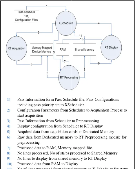
Figure 3 shows the DFD an XSTREAM software. The hardwa system is shown in Figure 4.
Figure 3. DFD-0 of XSTREA
pped Sequential
1) Pass Information form Pass Sched including pass priority etc to XSch 2) Configuration Parameters from Sc
start acquisition
3) Pass Information from Scheduler t 4) Display configuration from Sched 5) Acquired data from acquisition ca 6) Raw data from Dedicated memory
preprocessing
7) Processed data to RAM, Memory 8) No lines processed, No of strips pr 9) No lines to display from shared m 10) Processed data from RAM to Disp 11) No of lines processed from shared
updation
rocess architecture
TREAM softwareis designed ely ‘Real-Time(RT) stream ing’, ‘RT Full resolution scroll is to modularize and arrest the dule to others. Every process is independently.
is responsible for acquiring the es into host memory area.The in real-time or flushed after the k support. This procedure is tion in case of failure in RT
le is responsible for processing me. Processing includes all the
isplays the processed Level-1A lay. The display also provides h as scroll speed adjustments, ithin the strip and minimal stretch.This process can also be
ady processed strips.
the processes and displays the ges, alerts requiring immediate ll the real-time processes are f the main tasks of scheduler is iding pre-emptive priority based erride options.XScheduler polls ssion and updates the process
and process architecture of ware block diagram of the host
REAM Software modules edule file, Pass Configurations Scheduler
Scheduler to Acquisition Process to
er to Preprocessing eduler to RT Display cards to Dedicated Memory ory to RT Preprocessing module for
ory mapped file
ps processed to Shared Memory d memory to RT Display
isplay
red memory to X Scheduler for status The International Archives of the Photogrammetry, Remote Sensing and Spatial Information Sciences, Volume XL-8, 2014
Figure 4. Hardware block diagram of XSTREAM system
2.4 XSTREAM Software Implementation Specifications
The entire software is built on COTS hardware and Open platforms. Standard Linux Operating system with ANSI C/C++ language and gcc [18] compiler is used. On host side POSIX threads are used for exploiting all the cores in CPU, while OpenCL API is used for GP/GPU programming. OpenCL implementation is chosen because it is independent of the GPU provider and provides portability across all the computing devices viz., CPU, GPU, etc. OpenSceneGraph[19] is used for Real-time rendering of processed images on multi-screen display. The Scheduler module is developed using Qt [20] User Interface (UI) framework. Qt toolkit is lightweight and is an Open source project. For synchronize between all the modules within XSTREAM, standard POSIX inter process communication (IPC) mechanisms are adopted.
3. TEST RESULTS
The XSTREAM host systemhaving the configuration as listed in Table-2 is used for testing. The system was connected to COTS demodulator of M/S Cortex make at NRSC-Shadnagar. The COTS High Speed Data Acquisition Card supplied by M/S Apollo Microsystems[21], Hyderabad, was used to acquire data from the de-mod and was connected to PCI-X bus within the host system. The high speed acquisition card also had IRIG-B interface to stamp time on the valid frames.
CPU 2 x 12-core
Main Memory 32 GB DDR3
Operating System RHEL 6.2
GP-GPU for Compute NvidiaTesla-C2070 / AMDv9800
COTS Hardware Altera Stratix II FPGA GPU for Graphics
Display
2XnVidia Quadro6000 / 1xAMD v9800
Table-2: Hardware configuration of XSTREAM Host
The system was initially tested with Cartosat-2/2A/2B passes for all modes, such as Real-Time (RT), Solid State Recorder (SSR) Playback (PB) and mixed modes i.e., RT and PB. Later the software, with mission specific modifications, was also tested for Cartosat-1 and Resourcesat-2 missions. The system was continuously tested for more than a year and specific evaluations for the following data sets were performed to study the radiometric quality and geometric accuracies.
Test– 1:
Dataset: Cartosat-2A data, of orbit 18946 with a pass duration of 9 minutes 13 seconds.
The results of both processesi.e., conventional processing and XSTREAM processingare compared below.
No of Strips Latency Geometric
Accuracy Intended Sys-I Sys-II Sys-I Sys-II Sys-I Sys-II
6 6 6 ~2
hrs ~6 secs
100 mts
150 mts
Test - 2:
Dataset: Cartosat-2B data, of orbit number 68 with a pass duration of 10 minutes.
No of Strips within the pass Latency Geometric
Accuracy
Intended Sys-I Sys-II Sys-I Sys-II Sys-I
Sys-II
16 16 16 ~2 hrs ~6 secs 100
mts 130 mts
Sys-I as mentioned in the above table, is the conventional system, which consists of two Itanium based servers one performs data acquisition and Level-0 processing, while the second server performs the Level-1A processing in offline mode. The Sys-II is the XSTREAM host system having the configuration as shown in Table 2.
The radiometric quality was visually verified and found to be similar for both the products. Similarlythe Level-2 products generated from both chains showed similar accuracies.
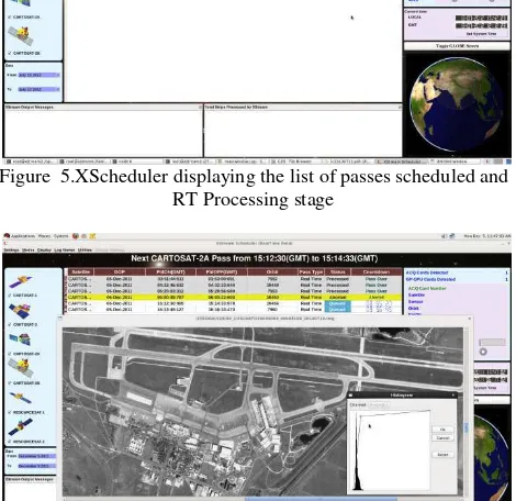
Sample Outputs:
Figure 5.XScheduler displaying the list of passes scheduled and RT Processing stage
Figure 6.XScheduler displaying the processes output The International Archives of the Photogrammetry, Remote Sensing and Spatial Information Sciences, Volume XL-8, 2014
4. CONCLUSIONS
Satellite payload data processing to generate level-1A product involves sequence of complex multiple tasks that need to be executed one after the other. Conventionally they are done on high server(s) in a sequential mode which is not only sub-optimal but also introduces substantial delays in actual usage of the data, thereby is not suitable for applications needing quick response. This work presents generation of level-1A products in real-time using a single heterogeneous computing platform namely XSTREAM having a combination of FPGA, GP/GPU and multi-core CPUs. The approach adopted involves re-engineering of all the software modules and careful orchestration among all computing entities within a single system and a single process.
The XSTREAM system is tested for Cartosat series of satellites having data rates of 105Mbps (2 (I&Q) X 52.5Mbps) and 210Mbps (4 X 52.5Mbps) downlink. All operational modes such as RT, PB, and SSR were tested and the products were generated in real-time (during the live-pass) with latencies between 6-10 seconds, by using 2 Socket CPU with 8 core each, along with one GP/GPU card per channel (I&Q) of data. The radiometric quality of both the products i.e., the product generated through normal offline mode and through XSTREAM appeared similar, while the geometric accuracies for generation level-1B was slightly inferior as compared to that of the offline processing. However, the level-2 product accuracy again showed similar results for the conventional offline processing as well as for on-line processing through XSTREAM.
The system is mission neutral, highly modular and independently scalable to support any future missions such as Cartosat-3 which has higher data rates. Future work is also oriented towards processing of SAR missions, such as RISAT-1 in which the challenge would be not only the high data rates but also signal processing. Another direction of work is to generate level-2 products in real-time with automatic identification of GCPs.
5. ACKNOWLEDGEMENTS
Authors would like to thank Director ADRIN, Director ISAC and Group Director-SEG-ADRIN for their continuous support and valuable guidance during the entire process of development of XSTREAM system.
The authors would also like to acknowledge and place on record the kind cooperation and support extended by Director NRSC, Scientist/Engineers, scientific staff and administration of NRSC for providing the necessary support to carryout developments and testing at NRSC Earth station Shadnagar.
REFERENCES
[1]http://www.nrsc.gov.in/pdf/hcartosat1.pdf : Cartosat-1 User
Handbook
[2]http://www.nrsc.gov.in/pdf/hresourcesat1.pdf : Resourcesat
User Handbook
[3] http://www.isro.org/satellites/cartosat-1.aspx
[4] http://www.isro.org/satellites/cartosat-2.aspx
[5] http://www.isro.org/satellites/irs-p6resourcesat-1.aspx
[6]
http://modaps.nascom.nasa.gov/services/about/nomenclature.ht ml
[7] http://en.wikipedia.org/wiki/PCI_Express
[8] https://www.khronos.org/opencl/
[9] http://openmp.org/wp/openmp-specifications/
[10] http://en.wikipedia.org/wiki/Heterogeneous_computing
[11] John E. Stone, David Gohara, andGuochun Shi. A Parallel Programming Standard for Heterogeneous Computing
Systems.Computing in Science and Engineering. May 2010; 12(3): 66-72. doi: 10.1109/MCSE.2010.69
[11] Craig Lee, Carl Kesselman, Stephen Schwab. Near-real-time Satellite Image Processing: Metacomputing in CC++. In CC++. Computer Graphics and Applications, 1996, pp 79-84.
[12]Yang Zhang, Dan Yu, Shilong Ma. Researches on real-time satellite data flow processing based on file buffer. Seventh International Conference on Natural Computation, ICNC 2011, DOI: 10.1109/ICNC.2011.6022348.
[13] Paolo Bientinesi, Jos R.Herrero, Enrique S. Quintana-Ort and Robert Strzodka.Parallel computing on graphics processing units and heterogeneous platforms. Concurrency and
Computation: Practice and Experience 2014. DOI: 10.1002/cpe.3411.
[14] DominikGrewe, Michael F.P.O'Boyle.A Static Task Partitioning Approach for Heterogeneous Systems Using OpenCL. Springer, Lecture Notes in Computer Science Volume 6601, 2011, pp 286-305.
[15]http://www.hdfgroup.org/HDF5/
[16] http://en.wikipedia.org/wiki/JPEG
[17]https://www.princeton.edu/~achaney/tmve/wiki100k/docs/R
edd-solmon_error_correction.html
[18] https://gcc.gnu.org
[19] http://www.openscenegraph.org
[20] http://qt-project.org
[21] High speed data acquisition and playback cards: www.apollo-micro.com/space.php