LEARNING FROM TYPHOON MIRINAE:
Urbanization and Climate Change
in Quy Nhon City, Vietnam
Dr. Michael DiGregorio
Boulder, CO USA
No part of this publication may be reproduced or copied in any form without written permission.
This project was funded by the Rockefeller Foundation
May 2013
Published by: Institute for Social and Environmental Transition-Vietnam Hanoi, Vietnam
Cover Image: Stephen Tyler Art Director: Michelle F. Fox
Editorial Assistance: Sarah O. Reed, and Bessie Delahunt
LEARNING FROM TYPHOON MIRINAE:
Urbanization and Climate Change
in Quy Nhon City, Vietnam
Dr. Michael DiGregorio
Institute for Social and Environmental Transition-Vietnam, DQGWKH%LQK'LQK&OLPDWH&KDQJH&RRUGLQDWLRQ2IÀFH
CONTENTS
1 Introduction 9
2 Methodology 11
3 Mirinae: A Chronology of the Flood 13
3.1 Cost of Damage 16
3.2 Reasons for the Storm’s Severity 20
3.3 Lack of Warning 21
3.4 Urbanization and Infrastructure Development 22
4 Evidence from Hydrological Modeling 27
4.1 Nhon Binh Area Plan 28
4.2 Climate Change 32
4.2.1 Temperature and Rainfall 33
4.2.2 Sea Level Rise 34
4.3.3 Increasing Frequency of Extreme Events 34
4.3 Nhon Binh Area Plan under the Impacts of Climate Change 37
5 Learning from Typhoon Mirinae 41
5.1 Recommendations and Rationale 42
5.2 Conclusions 47
ACKNOWLEDGEMENTS
Michael DiGregorio | 22 February 2013
and succinctly, combining the observations of our interviewees ZLWKVFLHQWLÀFUHVHDUFKDQGDQDO\VLV6DUDK5HHG'U1JKLHP Phuong Tuyen, Michelle Fox, and Bessie Delahunt reviewed WKHÀQDOGUDIWDQGIRUPDWWHGLWIRUSXEOLFDWLRQLQ(QJOLVKDQG Vietnamese. Ngo Le Mai, presided over our efforts, as she does with all ISET projects in Vietnam, as the chief negotiator, coordinator and enabler. Having worked with Mai for nearly a decade, I have to say she is a master of all three.
7KHÀQDOYHUVLRQRIWKLVUHSRUWZDVUHYLHZHGE\D
On November 2, 2009, typhoon Mirinae slammed into the coast of central Vietnam killing 122 people and causing $280 million in damage to property. While typhoons strike Vietnam each fall, the severity of this storm caught both meteorologists and local disaster relief professionals off guard. Storms like Mirinae are infrequent, but not unusual. Many have struck the coast of Central Vietnam in the past and, according to climate scientists, many more will do so in the future. Both citizens and the state are well aware of these seasonal risks and attempt to prepare for them before each storm season. Given this, the extent of damage and loss of life associated with typhoon Mirinae might come as a surprise. Has climate change begun to produce storms that are beyond their preparation and response capacities?1 Or have other factors within the
landscape changed to such a degree that former practices are no longer adequate?
1 Ministry of Natural Resources and the Environment. Power Plants not to Blame. Accessed on 30 NOV 2012 at http://www.monre.gov.vn/v35/ default.aspx?tabid=675&CateID=59&ID=75633&Code=KZZ8875633.
This report summarizes results that are provided in greater detail in two previously released studies. Both of these studies are available on request from the Binh Dinh Climate Change &RRUGLQDWLRQ2IÀFH&&&21 Our task in that research was to
analyze the causes of typhoon Mirinae’s severity and, using approved scenarios for climate change, assess the potential impacts resulting from implementation of the Area Plan for Nhon Binh to 2020. We carried out this research in nine stages.
1 Understand how farmers,
ÀVKHUPHQDQGVDOW
makers have historically
DGDSWHGWRWKHÁRRGSURQH
environment of the Ha Thanh River delta
2 Map a chronology of
WKHKLVWRULFDOÁRRGRI
November 2, 2009 based on detailed interviews, satellite imagery and site visits
3 Assess landscape changes in Nhon Binh prior to typhoon Mirinae
4 Determine whether and how landscape change
FRQWULEXWHGWRWKHÁRRGҋV
severity
5 Compare and evaluate previous studies of
ÁRRGLQJLQWKH+D7KDQK
River delta
6 Construct a hydrological model of the delta, using available rainfall, elevation
DQGVWUHDPÁRZGDWD
7 Apply the hydrological model to assess the
LPSDFWVRIDÁRRGHYHQW
similar to Mirinae under current conditions
8 Assess potential impacts
RIÁRRGLQJLIWKH1KRQ
Binh Area Plan is fully built, under various future climate change scenarios
9 Draw conclusions and suggest recommended actions
This process made it possible for us to start at the grassroots, XQGHUVWDQGWKHKLVWRU\RIÁRRGLQJLQWKH+D7KDQK5LYHUGHOWD and use the best available data to reach our conclusions and recommendations.
'L*UHJRULR0DQG+X\QK&9/LYLQJZLWK)ORRGV%RXOGHU&2 ,6(77R4XDQJ7RDQ;k\GЊQJP{KuQKWKЀ\YąQOȶXYЊFV{QJ+j
Thanh. HCMC: SIWRR.
On October 31, 2009, the Central Storm Forecasting Agency announced that typhoon Mirinae was powerful, rapid and would produce up to 400 mm of rain in Central Vietnam. On the same day, deputy Prime Minister Hoang Trung Hai issued disaster preparation instructions. On November 2, all public schools in Binh Dinh were closed and people were advised to prepare for a severe storm. As the moisture rich storm slammed into unusually cold air in the mountains that afternoon, heavy rain began to fall. Over the next two days, the hydro-meteorological station at Van Canh, Binh Dinh recorded 801 mm of rainfall. In Phu Yen, the province hardest hit by Mirinae, 78 people were killed. In Binh Dinh, 22 people were reported dead. In Khanh Hoa, to the south, another 14 deaths were reported.
7HUULEOHÁRRGVDUHQRWXQFRPPRQLQWKHÁRRGSODLQRIWKHORZHU Ha Thanh River. Men and women in their 80s can remember being told about the great Nham Ti storm of 1912, the mother of all storms, that wiped out whole villages. But these same people could also recall other extreme storms in their lifetimes. According to Binh Dinh’s Department of Agriculture and Rural Development, Mirinae was the worst storm in 34 years. Flood records analyzed by Province’s Hydro-Meteorological Center, however, show that extreme storms like Mirinae have occurred with a historical frequency of approximately once every 20 years.1
People living in Quy Nhon did not initially regard Mirinae as anything unusual. However, beginning at around 4 PM,
1 In other words, under historical climate conditions each year there is a 5% chance of experiencing such a storm, . As described in this report, under conditions of climate change, the frequency of extremes storms like Mirinae is likely to increase..
3.0
MIRINAE:
intensely heavy rain began to fall in the upper reaches of the Ha Thanh River near Van Canh. At its peak, the rainfall rate there was four times greater than rainfall in the city. Some residents of the highlands called friends and relatives in WKHORZODQGVWRGHVFULEHWKHXQSUHFHGHQWHGÁRRGWKDWZDV spreading across the landscape. Amazed at the stories, people LQWKHORZODQGVZHUHXQDZDUHWKDWWKHÁRRGZRXOGGHVFHQG on them. Looking out their windows, with no other information, Mirinae seemed to be just another seasonal storm.
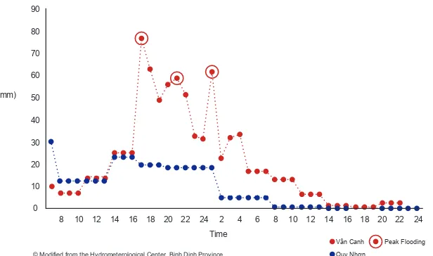
%\URXJKO\30WKHÁRRGWKDWKDGJDWKHUHGLQWKHXSSHU reaches of the Ha Thanh River had reached Dieu Tri town. Near the point where the Ha Thanh River divides into the 7UXRQJ8F5LYHUÁRZLQJWRWKHQRUWKDQGHDVWDQGWKH+XQJ Thanh River, to the south and east, a small seasonal stream, F I G U R E 1
HOURLY RAINFALL 2– 3 NOVEMBER 2009, VAN CANH AND QUY NHON
7KHÀJXUHEHORZVKRZVWKDWLWZDVUDLQLQJKHDYLHULQWKHKLOOVWKDQLWZDVLQWKHYDOOH\EHORZ This illustrates why the people in Quy Nhon felt like they were hit by a tsunami, because the amount of water that came down from Van Canh was like watching someone open a dam suddenly.
© Modified from the Hydrometerological Center, Binh Dinh Province
8 10 12 14 16 18 20 22 24 2 4 6 8 10 12 14 16 18 20 22 24
Vân Canh
4X\1KѫQ
NQRZQORFDOO\DVWKH&DW5LYHUEUDQFKHVRIIDQGÁRZVLQWR Nhon Phu ward. After entering the ward, the Cat River divides into a main branch, heading northeast towards Bridge No. 8, and a secondary branch, the Cay Me River, heading east to Bridge No. 7.
7KHÁRRGVODPPHGLQWR1KRQ3KXZDUGWKURXJKWKH&DW5LYHU at Van Ha village at around 6 PM, quickly spreading through the northern part of the ward, then under and over railroad bridges and into the eastern part of the ward near Highway 19. $WWKHVDPHWLPHÁRRGZDWHUVUXVKHGWKURXJK1JDQJ5LYHU Bridge into southern Nhon Phu ward. People living along a dike road between Van Ha and Ngang River Bridge watched the water rise, thinking they were safe, until they saw water swirling around the backs of their homes. Mr. Huynh Tan Son, who OLYHVRQWKHGLNHURDGVDLGKHKDGQHYHUVHHQÁRRGFRQGLWLRQV like this before. Shortly after passing the Ngang River Bridge, ÁRRGZDWHUVEURNHRYHUWKHEDQNVRIWKH+XQJ7KDQK5LYHU near Phu Vinh village. A local man sounded the alarm, banging on a makeshift gong as he yelled, “the dike is breached!” Between 7 and 8 PM, most areas of Nhon Phu ward had begun WRH[SHULHQFHÁRRGLQJ%\30ZDWHUUXVKLQJWKURXJKWKH'LQK Market River combined with water pouring through bridges on +LJKZD\WRSURGXFHÁRRGLQJQHDUWKH1KRQ%LQK,QGXVWULDO Area. Within a short time, houses in settlements near the river ZHUHÁRRGHGWRXQSUHFHGHQWHGOHYHOVDQGWKH,QGXVWULDO$UHD thought to be protected by its nearly two meter high foundation, P H OTO 1
DIVISION OF THE HA THANH RIVER NEAR VAN HA
M A P 1
R A NGE OF TIME FLOOD FIR S T A PPE A RED, BY FLOOD CELL S, 2-3 NOV EMBER
20 09. 12 HOUR S PA S SED FROM THE INITI A L A PPE A R A NCE OF THE FLOOD IN
VA N CA NH TO IT S A RRI VA L ON THE COA S T OF THI N A I L AGOON. DURING TH AT
TIME , THERE W ERE NO OFFICI A L WA RNINGS IN THE M A S S MEDI A .
4–5 pm
8–10 pm 7–9 pm
6–7 pm
10pm–4am TT TP
Quy Nhơn P. Nhơn Phú
TT Diêu Trì
TT Vân Canh Phú Yên Province
Hà Thanh River P. Nhơn
Bình
Thị Nại Lagoon
was also under water. By 10 PM, people living outside the eastern dike near Barrage No. 1 saw water rising in their yards. By 11 PM, they too were scrambling for safe places to escape WKHÁRRG$WWKHKHLJKWRIWKHÁRRGWKHZKROHGHOWDZDVXQGHU water ranging from roughly 1.5 to 2.5 m deep, depending on location.
3.1 COST OF DAMAGE
$FFRUGLQJWRWKHFLW\ҋV(FRQRPLF2IÀFHW\SKRRQ0LULQDH killed seven people and caused roughly $21 million US dollars ELOOLRQ91'LQGDPDJH2 Based only on this damage
assessment, Mirinae may have been the most costly storm to hit the city in living memory.
'HÁDWHG86GROODUVEDVHGRQDQH[FKDQJHUDWHRI91'SHU86'RQ
Table 1, below, lists the damage caused by the storm by HFRQRPLFVHFWRULQGHÁDWHG86GROODUV3 One number stands
out among the others. “Other Infrastructure,” accounting for nearly 50% of all damage due to Mirinae, primarily comprises losses to physical infrastructure, machinery, and goods within the city’s industrial areas, especially in the Nhon Binh Industrial Area. This area was built up about 2 m higher than surrounding land, yet still was severely damaged. Losses to the forestry sector, primarily in Phuoc My, follow with 12.9% of the total GDPDJH7KHQDJULFXOWXUHKRXVLQJOLYHVWRFN DQGGDPDJHWRGLNHVDQGLUULJDWLRQV\VWHPV ÀVKHULHVDQGWUDQVSRUW'DPDJHWRDOORWKHU categories was less than 1% of the total amount.
Map 2 and Table 2, on the following page, show the
distributionof damage caused by typhoon Mirinae by commune and ward.
3 Throughout this section, our reference is to the VND-USD exchange rate on 2NOV09.
TA B L E 1
DISTRIBUTION OF DAMAGE BY SECTOR
Sector Amount Percent
Health $784 0.0%
Education $40,031 0.2%
Boats & Tackle $87,397 0.4%
Transport $369,520 1.8%
Fisheries $379,710 1.8%
Dikes and Irrigation $1,076,368 5.1%
Livestock $1,207,715 5.8%
Housing $1,343,430 6.4%
Agriculture $1,975,813 9.4%
Forestry $2,708,023 12.9%
Other Infrastructure $10,432,171 49.8%
M A P 2 AND TABLE 2
DAMAGE ASSESSMENT BY COMMUNE AND WAR
1 2 3
4
5
1 Nhon Binh
$11,037,288 in damage, including nearly $10 million in damage within the Nhon Binh Industrial Area. The ward also
VXIIHUHGLQORVVHVWRDJULFXOWXUHDQGÀVKHULHVODUJHO\ UHSUHVHQWHGLQWKHYDOXHRISDGG\ORVWLQVWRUDJHWRQV DQGHURGHGÀVKDQGVKULPSSRQGVKD
2 DONG DA
$433,598 in damage. Fisheries, boats and tackle accounted for 70 percent of the total.
3 NHON PHU
$3,840,602 in damage. Out of 2,302 houses damaged or destroyed GXHWRWKHÁRRGZLWKDWRWDORI86 dollars, were in Nhon Phu. In addition, Nhon Phu lost nearly half the total number of chickens and ducks, 40 percent of the paddy
ORVWLQVWRUDJHSOXVRQHÀIWKRIWKHSLJVEXIIDORHVDQGFDWWOH
4 TRAN QUANG DIEU
$348,917 in total damage. Damage to dikes and irrigation systems accounted for about one-third of the cost.
5 BUI THI XUAN
$1,202,564 in damage. About half of the ward’s losses were related WRDJULFXOWXUHÀVKHULHVDQGIRUHVWU\DQGDERXWSHUFHQW were due to damage in the ward’s industrial zones.
6 PHUOC MY
The distribution of damage tells us something of the nature RIWKHVWRUP$JULFXOWXUDODQGÀVKHULHVORVVHVZHUHUHODWLYHO\ ORZEHFDXVHIDUPHUVDQGÀVKHUPHQKDUYHVWWKHLUÀHOGVDQG ponds before the annual storm season begins. However, stored paddy losses and livestock losses were relatively high. 7KLVWHOOVXVWKDWIDUPHUVKDGYHU\OLWWOHZDUQLQJRIWKHÁRRG With little time to react, they were not able to protect their paddy or move livestock to safety. The suddenness, force DQGGHSWKRIWKHÁRRGDOVROLPLWHGWKHLUDELOLW\WRSURWHFWWKHLU homes and property. This was particularly the case in Nhon Phu ward where nearly all the damage to homes occurred. In comparison, the coastal areas of Thi Nai lagoon, and the ocean front areas of the central city and Nhon Ly commune suffered relatively little damage. Typhoon Mirinae’s impacts ZHUHSULPDULO\DVVRFLDWHGZLWKÁRRGLQJRIULYHUVDQGVWUHDPV in the Ha Thanh River delta. These impacts extended up into the mountainous areas of Phuoc My commune where intense rainfall on thin soils produced sheet erosion that wiped out 19 square kilometers of industrial forest plantations.
3.2 REASONS FOR THE STORM’S SEVERITY
,QPRVWFDVHVÁRRGLQJLVFDXVHGE\DFRPELQDWLRQRIZHDWKHU conditions, watershed management practices, inappropriate mixtures of land uses, and infrastructure failures. In the case of typhoon Mirinae, heavy rainfall on the eroded slopes of mountains and populated agricultural valleys of the upper Ha Thanh River watershed created conditions for a disaster downstream. Between 4 and 5 PM on the evening of
November 2, 2009, rainfall in this area averaged nearly 80 mm SHUKRXU$WWKLVUDWHÁRRGZDWHUVZHSWRYHUWKHVWHHSVORSHV of eroded hills in the highlands down into the Ha Thanh River, bursting over dikes and other barriers as it gathered into a PDVVLYHÁRRG%DVHGRQRXUGDWDVRXUFHVÁRRGVJHQHUDOO\ RFFXUZKHQVWUHDPÁRZLQWKHXSSHU+D7KDQK5LYHULVJUHDWHU than 1,226 m3VHF'XULQJWKH1RYHPEHUÁRRGWKH
VWUHDPÁRZUDWHDW9DQ&DQKUHDFKHGDSHDNRIP3/
sec. At Dieu Tri town, where the Ha Thanh River enters the GHOWDWKHVWUHDPÁRZUDWHURVHWRP3/sec. In both cases,
VWUHDPÁRZZDVQHDUO\WKUHHWLPHVWKHVDIHOHYHO
opened. This was indeed the case of dams on the Ba Ha River in nearby Phu Yen province. The release of water from these dams, which contributed to the loss of 78 lives in the province, was reported in the media and debated in the National $VVHPEO\7KHVXGGHQQHVVRIWKHÁRRGFRPELQHGZLWKVWRULHV from Phu Yen led many of the people we interviewed to believe that the release of water from upstream reservoirs made the ÁRRGZRUVHWKDQLWVKRXOGKDYHEHHQ:KLOHRXUUHVHDUFK
3.3 LACK OF WARNING
Thi Nai Lagoon until after midnight, was a major failure of the disaster management system, and the cause of many personal tragedies.
3.4 URBANIZATION AND INFRASTRUCTURE DEVELOPMENT
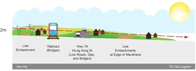
,QDGGLWLRQWRDODFNRIZDUQLQJUHVLGHQWVRIWKHÁRRGSODLQ LGHQWLÀHGXUEDQL]DWLRQDQGXQFRRUGLQDWHGLQIUDVWUXFWXUH GHYHORSPHQWDVFDXVHVIRUWKHVHYHULW\RIWKHÁRRG,QWKHSDVW there were relatively few barriers in the Ha Thanh River delta. Thus, with a slope of roughly 8 m over a distance of 8 m, DPKLJKÁRRGULVLQJLQ1KRQ3KXZRXOGJUDGXDOO\GLVVLSDWH as it passed through railroad bridges, over agricultural land, over the previously lower Highway 19 and Hung Vuong Street, and into Thi Nai Lagoon. Bamboo planted along rivers and VWUHDPVVORZHGÁRRGFXUUHQWVDQGUHGXFHGGDPDJHFDXVHGE\ IDVWÁRZLQJZDWHU0U'R7KDQK7LQQRZLQKLVVZDVWKH ÀUVWWRGHVFULEHWKLVSDWWHUQRIKLVWRULFDOÁRRGLQJWRXV2WKHU people offered additional details. We represent this model of KLVWRULFDOÁRRGLQJDVDWUDQVHFWRIWKHGHOWDLQ)LJXUHEHORZ
,QÁRRGZDWHUVXUJHGXSWKH&DW5LYHULQWR1KRQ3KX and swept over the rail line and Highway 19, over dikes along
F I G U R E 2
TRANSECT OF HISTORICAL FLOOD PAT TERN
2m
Railroad (Bridges)
Hwy 19 Hung Vong St (Low Roads, Dips,
and Bridges) Low
Embankment
Low Embankments at Edge of Marshland
© Michael DiGregario, 2009
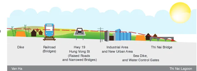
the Hung Thanh River, over the foundation of the Nhon Binh Industrial Area, and over the eastern dike. Floodwater also topped sections of the dike along the Truong Uc River in northern Nhon Binh and sections of Hung Vuong Street in southern Nhon Phu. Depending on the location, the depth of ÁRRGZDWHUFRPLQJRYHUWKHVHEDUULHUVZDVEHWZHHQDQG cm. In addition, the smooth surfaces of dikes and the narrowed FKDQQHOVRIÁRRGZD\VFUHDWHGVZLUOLQJSRROVDQGIDVWPRYLQJ currents that knocked down walls and undermined foundations.
)LJXUHLOOXVWUDWHVWKHQHZK\GURORJ\RIWKHÁRRGSODLQ P H OTO 2
Barriers such as raised highways, rail lines, and dikes create ´ÁRRGFHOOVµLQZKLFKZDWHUULVHVEHIRUHSRXULQJLQWRWKHQH[W FHOO,PDJLQHWKHVHÁRRGFHOOVOLNHDVHULHVRILQWHUFRQQHFWHG EDWKWXEV,IWKHÁRZRIZDWHUHQWHULQJHDFKWXELVJUHDWHUWKDQ WKHÁRZRIZDWHUGUDLQLQJRXWWKHOHYHORIZDWHULQHDFKWXEZLOO rise, until it spills over into the next tub. This analogy explains ZK\WKHÁRRGZKLFKDSSHDUHGLQ9DQ+DDW30URXJKO\ RQHKRXUDIWHUÁRRGLQJVWDUWHGPXFKIDUWKHUXSVWUHDPGLG not reach villages outside the eastern dike until 10 PM. Water SDVVHGWKURXJKEULGJHVDQGJDSVLQGLNHVIURPRQHÁRRGFHOO to the next. As the capacity of these bridges and gaps was UHDFKHGÁRRGZDWHUEHFDPHGHHSHU:KHQLWWRSSHGURDGV DQGGLNHVPRUHÁRRGZDWHUSRXUHGLQWRWKHQH[WÁRRGFHOO ZKLFKUHSHDWHGWKHSURFHVVXQWLOWKHÁRRGHYHQWXDOO\UHDFKHG the lagoon. Luckily, the tide in the lagoon was receding. If WKHWLGHKDGEHHQULVLQJWKDWHYHQLQJRULIWKHÁRRGKDGEHHQ DFFRPSDQLHGE\DVWRUPVXUJHWKHÁRRGLQJZRXOGKDYH been even higher and lasted longer. Experience of the 2009 storms very clearly demonstrates the importance of improving GUDLQDJHLQWKHGHOWDE\PDNLQJURRPIRUÁRRGVE\JUHDWO\ ZLGHQLQJEULGJHVLQÁRRGFKDQQHOVDQGVHWWLQJDVLGHZLGH ÁRRGSODLQV
F I G U R E 3
TRANSECT OF 2009 FLOOD PAT TERN
2m and New Urban Area
Thi Nai Bridge Dike
Sea Dike, and Water Control Gates
4.0
EVIDENCE FROM
HYDROLOGICAL
MODELING
Much of what we have noted so far is based on interviews, satellite imagery and damage assessments. As part of this research, the Southern Institute of Water Resources Research also constructed hydrological models based on historical UDLQIDOOVWUHDPÁRZDQGHOHYDWLRQGDWD:HXVHGWKHVHPRGHOV WRDQDO\]HDVHYHUHÁRRGLQDQGWKHH[WUHPHÁRRGRI 2009.1 The model suggests that new urban infrastructure
and construction up to 2009 increased the level of the 2009 ÁRRGE\URXJKO\FPRYHUDOOZLWKVLJQLÀFDQWO\GLIIHUHQW LPSDFWVDWVSHFLÀFORFDWLRQV)RUH[DPSOHZKLOHWKHLPSDFWV of urbanization and infrastructure construction were minimal at 'LHX7UL%ULGJHFPRXUPRGHOHVWLPDWHVWKDWLPSDFWVDW 1JDQJ5LYHU%ULGJHFPDQG%ULGJH1RFPZHUH PXFKPRUHVLJQLÀFDQW
2QFHZHXQGHUVWRRGKRZÁRRGZDWHUEHKDYHGXQGHUWKHVH FRQGLWLRQVZHZHUHDEOHWRXVHUDLQIDOOVWUHDPÁRZDQGÁRRG data to simulate full implementation of the current Area Plan for Nhon Binh, what we call the “build out” scenario. Using climate change scenarios developed by IMHEN, we then assessed WKHEXLOGRXWVFHQDULRLQWHUPVRISRWHQWLDOÁRRGULVNVXQGHU conditions of climate change and sea level rise.
1 Throughout this report, we use the words “seasonal”, “severe” and “extreme”
WRUHSODFHÁRRGSUREDELOLW\DVVHVVPHQWVEDVHGRQKLVWRULFDOGDWD&OLPDWH FKDQJHLVPDNLQJHVWLPDWHVIRUDQGÁRRGVXQUHOLDEOH
4.1 NHON BINH AREA PLAN
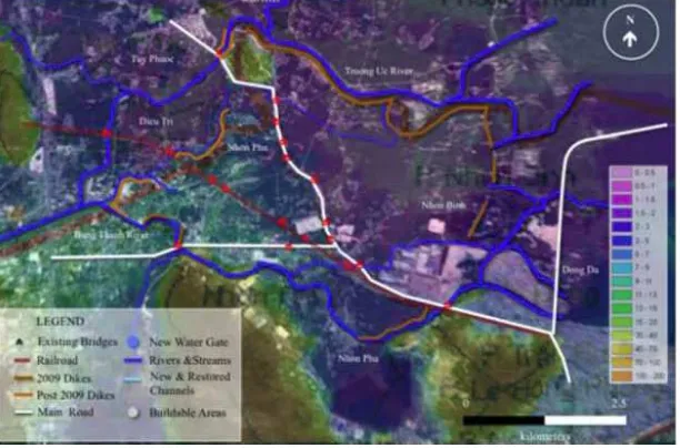
The Nhon Binh Area Plan2, presented in Map 3 on the following
page, calls for urbanizing roughly one-third of the ward’s area. Some of the planned infrastructure, residential areas, and public facilities have already been built or are currently under construction. This includes the Nhon Binh Industrial Area3
DQGWKUHHQHZUHVLGHQWLDODUHDVDVZHOODV4XDQJ7UXQJ 8QLYHUVLW\626YLOODJHDQHZ'LQKPDUNHWDQGD ZDVWHZDWHUWUHDWPHQWSODQW$QHZXUEDQDUHDVRXWKHDVW RIEULGJH1RRQ+LJKZD\DQGDUDLOFDUJRWUDLQVWDWLRQ have been planned but not yet constructed. A corridor behind KRXVHVZHVWRI+LJKZD\ZLOOEHXVHGWROLQNDÁRRGZD\ through New Bridge, now blocked by Quang Trung University, DQGDÁRRGZD\WKURXJK+LJK%ULGJHWRWKHQRUWK'RZQVWUHDP IURP1HZ%ULGJHÁRRGZDWHUZLOODOVREHURXWHGWKURXJKD 4.76 ha park, into a canal that connects to the urban drainage system, and eventually into the Dinh Market River. Below High Bridge, water will enter a 7.22 ha green space, pass under a QHZURDGDQGLQWRWKHUHVHUYHGÁRRGZD\WR%DUUDJHVDQG $ÁRRGZD\WKDWFXUUHQWO\SDVVHVXQGHU+XQJ9XRQJ6WUHHW and into southern Nhon Phu will be blocked by Quang Trung University. Another stream on the south side of the university passes under a bridge on Highway 19 and into the Dinh Market River. The university will also block this stream.
Using a baseline foundation level of 4 m above sea level, if the Area Plan for Nhon Binh is fully implemented without any LPSURYHPHQWRIH[LVWLQJGUDLQDJHLQWKH+XQJ7KDQK1JDQJ DQG7UXRQJ8F5LYHUVUDLQIDOODQGVWUHDPÁRZUDWHVVLPLODUWR FRQGLWLRQVGXULQJWKHÁRRGLQ1RYHPEHUFRXOGSURGXFH ÁRRGZDWHUFPGHHSHUDW'LHX7UL%ULGJHFPGHHSHU at Coconut Tree Weir, 70 cm deeper at Ngang River Bridge, and 76 cm deeper at Phu Hoa Weir. Under the same build out conditions, lower baseline foundation levels would result
2 On 13 SEP 2012, after research for this report was completed, the Binh Dinh People’s Committee approved a revised area plan for Nhon Binh and Nhon Phu. As will be noted below, some of the issues raised in this report have been incorporated in that plan.
LQORZHUÁRRGKHLJKWLQFUHDVHVDWHDFKRIWKHVHSRLQWVEXW increased overtopping of roads and new urban and industrial areas within Nhon Binh. In either case, these increases are VLJQLÀFDQW&RQVLGHU1JDQJ5LYHU%ULGJH0U+X\QK7DQ6RQ who lives on the dike road here, showed us a mobile phone video he took at around 1 AM on November 3, 2009. In the YLGHRÁRRGZDWHULVSRXULQJRYHUWKHPKLJKGLNHURDGLQIURQW of his house at a height of 20 to 40 cm. Now, consider adding DQRWKHUFPWRWKLVÁRRGOHYHO,QVWHDGRIWRFPRI water pouring over the dike, people living below would face a 1 m high wall of water descending on them. Consider also the situation in southern Nhon Phu ward. Mr. Nguyen Dinh Ba built his house near the Phu Hoa Weir on a 1 m high foundation. He thought one meter would be enough to protect his home IURPSRWHQWLDOÁRRGV+HZDVZURQJ'XULQJWKHKLVWRULFÁRRG
P H OTO 3
QUANG TRUNG UNIVERSIT Y AND NEW BRIDGE
Van Son, who also lives in Phu Hoa, told us about elderly people in the lowest areas of the village who were trapped in WKHDWWLFVRIWKHLUKRPHVVWUXJJOLQJWRÀQGDLULQWKHWLQ\VSDFH EHORZWKHSHDNRIWKHLUURRIV,IWKHÁRRGKDGEHHQMXVWDOLWWOH higher, they would have drowned. Now consider an increase of FPRIÁRRGZDWHUDW3KX+RD:HLUDQG\RXZLOOXQGHUVWDQG the potential impacts of building out the Nhon Binh Area Plan ZLWKRXWPRGLÀFDWLRQV
All of these risks increase under the conditions of climate change and sea level rise.
4.2 CLIMATE CHANGE
The global climate is changing as a result of human emissions of greenhouse gases.4 Most of these emissions have
historically come from the wealthy developed countries, but emerging economies like Vietnam and China are now contributing more and more to the problem. As long as emissions continue, climate change will accelerate. It is crucial to recognize that this is not a case of shifting from one historical climate to some future stable climate. As far as 0LQLVWU\RI1DWXUDO5HVRXUFHVDQG(QYLURQPHQWDO1DWLRQDO
we can see into the future, climate will continue to change more and more rapidly. Cities last a long time: Hanoi recently celebrated its 1000th anniversary. If Quy Nhon city expands LQDZD\WKDWGRHVQRWUHÁHFWFKDQJLQJFOLPDWHULVNVLWZLOOQRW only put many future residents in danger, but it may require future local governments to make massive investments in relocation or rebuilding. The best solution is good planning now.
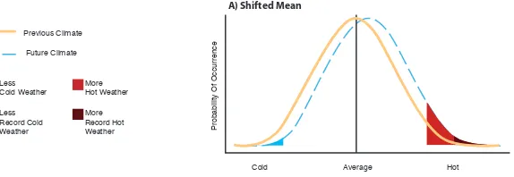
Planning for climate change means recognizing that events that now seem extreme will occur with greater frequency in the future. At the same time, the magnitude of extreme events may LQFUHDVHHJKHDWZDYHVZLOOEHKRWWHULQWHQVHVWRUPVZLOO EHFRPHHYHQPRUHLQWHQVH
Using even the most optimistic scenario for reduction of future emissions,5 the Institute of Meteorology, Hydrology and the
Environment has presented model projections showing that central Vietnam will experience hotter summers, longer and more intense periods of drought, and more frequent and more
5 The B2 scenario. See http://en.wikipedia.org/wiki/Special_Report_on_ Emissions_Scenarios for more information.
intense tropical storms. These climate changes would have the following impacts:
% LQFUHDVHGÁRRGLQJGXULQJWKHVWRUPVHDVRQ
% increased need to release water from hydropower dams in the storm season and store water during dry seasons,
UHVXOWLQJLQLQFUHDVHGÁXFWXDWLRQLQULYHUOHYHOV
% very high daytime temperatures in the summer with the possibility of extended heat waves;
% steadily rising sea levels;
% increased impacts from storm surges especially when combined with high tides; and
% increased salinization of groundwater during periods of annual drought.
4.2.1 Temperature and rainfall
IMHEN has projected6 that the current pattern of seasonally
intense rainfall will increase and that it will be accompanied by more frequent drought during the dry season. This is expressed in its reports as an increase in monthly mean precipitation of 4% in Quy Nhon during the storm season over WKHFRPLQJ²\HDUV+RZHYHUEHFDXVHRIWKHLQVWDELOLW\ of rainfall patterns, in any given year, Quy Nhon could be struck by either unusually heavy rainfall or an extreme drought. For this reason, IMHEN has forecast periodic water shortages in Quy Nhon as early as 2020. For hydropower dam operators, the variability of seasonal weather patterns will compel managers to make hard choices between power JHQHUDWLRQDQGÁRRGPDQDJHPHQW'XULQJGU\VHDVRQVZKHQ water is needed for agriculture, livestock and human use, dam operators will be forced to conserve water to protect power generation. During storm seasons, when dams could provide ÁRRGVWRUDJHFDSDFLW\GDPRSHUDWRUVZLOOEHIRUFHGWRUHOHDVH water to protect their infrastructure. Already, we have seen rivers below hydroelectric dams in nearby Phu Yen become 9DQDQG7KDL&OLPDWHFKDQJHLPSDFWVDQGDGDSWDWLRQPHDVXUHVIRU
GHVHUWVLQWKHGU\VHDVRQDQGÁRRGFKDQQHOVLQWKHVWRUP season.7
4.2.2 Sea level rise
$FFRUGLQJWRWKHPHGLXPHPLVVLRQVFHQDULR%VHDOHYHO could rise 26 cm by 2050. More recent research has shown that sea levels are actually rising 60% faster than earlier models predicted, so the latest science suggests these values need to be updated.8 In the dry season, when there is
less fresh water underground, rising sea levels would push saltwater further inland through groundwater, affecting fresh water wells, river systems, and agriculture. Rising sea levels also mean that higher tides will erode beaches and threaten coastal property. More severe storms will lead to even higher water from storm surges and waves.
4.2.3 Increasing frequency of extreme events
Weather is always variable and future climate cannot be SUHGLFWHGZLWKDKLJKGHJUHHRIFRQÀGHQFH:KDWZHFDQEH very sure of is that the future climate in Binh Dinh province, as everywhere else in the world, will be different than recent historical conditions. IMHEN’s climate scenario projections describe changes in average future conditions. These average conditions do not, however, provide much information about extreme events. In the past, whether we describe temperature or precipitation, the natural range of variability for any given day will most frequently be close to the mean value for that month or season. However, as climate changes, the probability of variations from this historical mean will also change. In the IXWXUHZKHQWKHPHDQYDOXHFKDQJHVHJDLUWHPSHUDWXUH LQFUHDVHVE\GHJUHHVRUSUHFLSLWDWLRQE\ZHGRQRW know whether the probability distribution of variability will stay 2IÀFLDOVDWGDPSURYLQFHSRLQWWRGHDGULYHUVSRRUOLYLQJ7KDQK1LHQ1HZV
December 29, 2011. Accessed on 7DEC2012 at http://www.thanhniennews.
FRPSDJHVRIÀFLDOVDWGDPSURYLQFHSRLQWDWGHDGULYHUV
poor-living.aspx
/HPRQLFN0'6HD/HYHO5LVH$FFHOHUDWLQJ)DVWHUWKDQ,QLWLDO
WKHVDPH)LJXUHD9RUZKHWKHUYDULDELOLW\ZLOOLQFUHDVHE
or if the shape of the probability distribution will itself change F1RWHWKDWLQDOOWKHVHFDVHVH[WUHPHHYHQWVPD\LQFUHDVH in frequency even with a small change in the mean value.
In the past we assumed that climate was stable, and so ZHFRXOGHVWLPDWHWKHSUREDELOLW\RIDÁRRGLQDQ\\HDUE\ comparing the historical frequency of extreme events. This is QRORQJHUSRVVLEOH7KHSUREDELOLW\RIDJLYHQOHYHORIÁRRGLQJ seems to be steadily and slowly increasing every year. It no ORQJHUPDNHVPXFKVHQVHWRWDONRID´ÁRRGµ$ÁRRGWKDW would occur with 1% probability this year may occur with a PXFKKLJKHUSUREDELOLW\LQ\HDUV6RWKHOHYHORIÁRRGLQJ WKDWZHFDOODRU\HDUÁRRGWRGD\PLJKWEHFRPHD
9 Lavell, A., M. Oppenheimer, C. Diop, J. Hess, R. Lempert, J. Li, R.
Muir-:RRGDQG60\HRQJ&OLPDWHFKDQJHQHZGLPHQVLRQVLQGLVDVWHU
risk, exposure, vulnerability, and resilience. In: Managing the Risks of Extreme Events and Disasters to Advance Climate Change Adaptation. In Field, C.B., V. Barros, T.F. Stocker, D. Qin, D.J. Dokken, K.L. Ebi, M.D. Mastrandrea, K.J. Mach, G.-K. Plattner, S.K. Allen, M. Tignor, and
300LGJOH\HGV$6SHFLDO5HSRUWRI:RUNLQJ*URXSV,DQG,,RIWKH ,QWHUJRYHUQPHQWDO3DQHORQ&OLPDWH&KDQJH,3&&&DPEULGJH8QLYHUVLW\
Press, Cambridge, UK, pp. 25-64.
F I G U R E 4
THE EFFECT OF CHANGES IN TEMPERATURE DISTRIBUTION ON EXTREMES.
RU\HDUÁRRGDQGVRRQ7KXV0LULQDHOLNHÁRRGVZLOOOLNHO\ become more common. This poses real challenges for civil engineers who have relied on these standards for decades. 6KRXOGWKH\UDLVHWKHLUWROHUDQFHWRÁRRGULVNIURPWR RUHYHQD\HDUÁRRG",IVRKRZKLJKVKRXOGWKH\ EXLOGIRXQGDWLRQVKRZZLGHVKRXOGWKH\EXLOGÁRRGZD\VKRZ high should dikes be, and how wide should they make bridges?
Flood risk assessments based on the probability of extreme climate events at some future point in time might be able to resolve these problems. Unfortunately, the data needed to conduct an extreme event analysis and project the results into the future was not available at the time of this project. But even if this kind of assessment were available, it could only SURYLGHDYHU\ZHDNEDVLVIRUGHFLVLRQPDNLQJDERXWÁRRG FRQWUROLQIUDVWUXFWXUHVSHFLÀFDWLRQV7KHFDOFXODWLRQWKDW FLW\PDQDJHUVZDQW²DFRPSDULVRQRIWKHFRVWVRIGDPDJH RYHUDFHUWDLQSHULRGRIWLPHUHODWLYHWRWKHFRVWRIVSHFLÀF ÁRRGFRQWUROLQIUDVWUXFWXUH²LVH[WUHPHO\GLIÀFXOWWRFDOFXODWH with reliability under changing climate conditions. For these reasons, we believe that planning for multiple mechanisms to reduce the impact of extreme climate events under a wide range of conditions offers more reliable risk reduction. This DSSURDFKZRXOGDYRLGFDWDVWURSKLFÁRRGVE\DFFHSWLQJWKDW design values for any climate related project may be exceeded
B) Increased Variability
&ROG $YHUDJH +RW
3UREDELOLW\2I2FFXUUHQFH 3UREDELOLW\2I2FFXUUHQFH
&ROG $YHUDJH +RW
under extreme conditions. This “safe failure” approach could mean designing dikes or roads that can be safely overtopped LQH[WUHPHÁRRGVDOORZLQJÁRRGZDWHUWRÁRZXQREVWUXFWHG through wide channels that are protected from intensive urban development, or preserving large areas of low-lying wetlands WRVWRUHDQGUHOHDVHÁRRGZDWHUWKDWZRXOGRWKHUZLVHLPSDFW newly urbanized areas. It could also mean strengthening upstream forest and reservoir management or improving warning systems and community disaster response. No VLQJOHVROXWLRQLVVXIÀFLHQWWRSURYLGHVDIHW\XQGHUDOOIXWXUH FRQGLWLRQV3ODQQHUVPXVWH[SHFWWKDWÁRRGVZLOOLQFUHDVHWKDW rainfall intensity will be unpredictable, and that every single preventive measure is likely to fail. Total reliance on single SXUSRVHGUDLQDJHDQGÁRRGFRQWUROGLNHVZLOOSURYLGHIDOVH security. By planning for safe failure multiple mechanisms for ÁRRGFRQWUROHQJLQHHUVFDQORZHUWKHULVNRIWKUHDWVEHFRPLQJ disasters under unpredictable climate conditions.
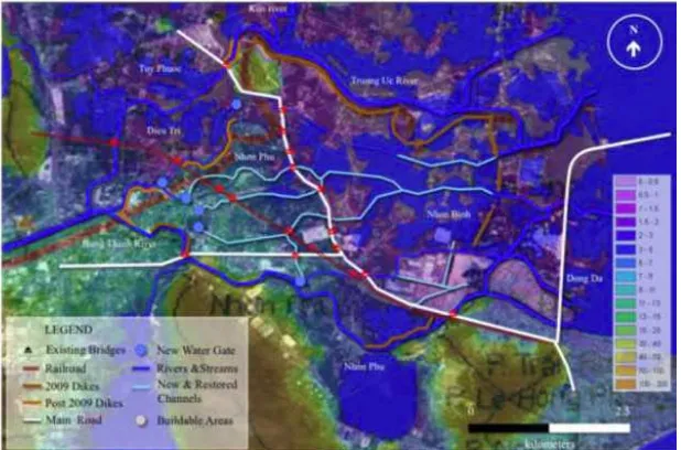
4.3 NHON BINH AREA PLAN UNDER THE IMPACTS OF CLIMATE CHANGE
Under all climate change scenarios, our hydrological model indicates that build out of the Nhon Binh Area Plan results LQLQFUHDVHGÁRRGLQJLQVXUURXQGLQJZDUGVDQGFRPPXQHV Under the medium climate scenario for 2050, for example, given sea level rise of just 26 cm, if the Area Plan for Nhon %LQKLVIXOO\LPSOHPHQWHGDÁRRGVLPLODUWRWKHKLVWRULFÁRRG of 2009 would produce water levels 77 cm higher at Dieu Tri Bridge, 90 cm higher at Ngang River Bridge, 41 cm higher at Coconut Tree Weir, and 89 cm higher at Phu Hoa Weir.
Our hydrological model could not be reliably calibrated for seasonal streams entering Nhon Binh through Bridge No. 7 and 8. For this reason, we have relied on information from our ÀHOGZRUNWRDVVHVVWKHLPSDFWVRIÁRRGLQJLQ1KRQ%LQKXQGHU conditions of climate change and full build out of the plan.
Following our digital elevation model, both bridges are located at low points in the terrain, each being roughly 1 m above sea OHYHO$GGLQJDOORIWKLVWRJHWKHUVXJJHVWVWKDWÁRRGZDWHUKHUH UHDFKHGDKHLJKWRIDERXWPDERYHQHDUE\ULFHÀHOGVGXULQJ WKHÁRRG7KLVÀWVZLWKLQWKHUDQJHRIÁRRGKHLJKWVDWRXU interview sites in Nhon Binh.
New construction in this area has been built on foundations at the same level or slightly higher than Highway 19, that is, roughly 3 m above sea level. During Typhoon Mirinae, ÁRRGZDWHUSDVVHGXQGHUHLJKWEULGJHVDORQJ+LJKZD\ DQGEHFDXVHWKLVGUDLQDJHFDSDFLW\ZDVLQVXIÀFLHQWWRSSHG over the highway into Nhon Binh. Currently, buildings lining both sides of the highway have created additional barriers to WKHGLVFKDUJHRIÁRRGZDWHU$VDUHVXOWLQDQRWKHUVWRUPOLNH 0LULQDHÁRRGZDWHUZLOOEHFRPHGHHSHUEHKLQGWKHFRPELQHG barriers of the road and buildings and will be forced primarily
M A P 4
INCREASED FLOOD HEIGHT DUE TO BUILD - OUT AND CLIMATE CHANGE (26 CM SEA LEVEL RISE SCENARIO)
north to Bridges No. 7 and 8. If the Nhon Binh Area Plan is FRQVWUXFWHGDVSODQQHGWKLVÁRRGFKDQQHOZRXOGEHERXQGHG on the north by a proposed highway connecting Nhon Hoi to Tuy Phuoc, and on the south, by the new residential area.
Under these conditions, we expect another storm like Mirinae to severely impact people living in settlements within the ÁRRGZD\LQERWK1KRQ%LQKDQG1KRQ3KX6XFKDVWRUPZRXOG DOVROLNHO\FDXVHGDPDJHWRDQHZUDLOFDUJRVWDWLRQDQGÁRRG Quang Trung University, Binh Dinh College, SOS village, the new Dinh Market, the new residential area, and all other urban DQGLQGXVWULDODUHDVLQ1KRQ%LQK0DS
Taking all this evidence together leads us to several general conclusions for the management of urbanization and climate change in the lower Ha Thanh River. We begin with an observation that we heard repeated many times by long-time residents of Nhon Binh: :KDWHYHUUHGXFHVWKHÁRZRIZDWHU LQWR7KL1DLODJRRQLQFUHDVHVÁRRGLQJ. As typhoon Mirinae has LOOXVWUDWHGLQDQH[WUHPHVWRUPÁRRGZDWHUZLOOEDFNXSEHKLQG URDGVDQGGLNHVZLWKLQWKHÁRRGSODLQ5HGXFLQJWKHHIIHFWRI EDUULHUVLQWKHÁRRGSODLQZKLOHFRQFXUUHQWO\PDQDJLQJWKHÁRRG protection and water management system to improve drainage is the only sustainable means of reducing threats associated ZLWKÁRRGLQJERWKQRZDQGXQGHUWKHORQJHUWHUPLQÁXHQFHRI climate change.
6HFRQGZHXQGHUVWDQGWKDWXQFRQWUROOHGÁRRGLQJLQH[WUHPH events is costly in terms of lives and property. At the same WLPHVHDVRQDOÁRRGLQJSURYLGHVEHQHÀWVWRDJULFXOWXUHZKLOH also recharging groundwater and holding salinization in check. ,QSULQFLSOHWKHUHIRUHÁRRGSURWHFWLRQDQGZDWHUPDQDJHPHQW LQIUDVWUXFWXUHVKRXOGDOORZIRUVHDVRQDOÁRRGLQJZKLOH
protecting people and property from life-threatening climate events.
Third, we expect that if the current Area Plan is fully
LPSOHPHQWHGZLWKRXWPRGLÀFDWLRQÁRRGLQJZLOOEHFRPHZRUVH and damage and loss of life from a storm like Mirinae would be much higher.
5.0
LEARNING FROM
Based on these conclusions, we offer some suggestions for ORFDOJRYHUQPHQWDFWLRQWRUHGXFHFXUUHQWÁRRGULVNVDQG increase resilience to future climate change. These actions are described below in order of priority. Each action would require further study and detailed design, but all are within the capacity and mandate of existing provincial technical departments.
5.1 RECOMMENDATIONS AND RATIONALE
1. 5HGXFHWKHÁRRGULVNWRH[LVWLQJVHWWOHPHQWVLQ
1KRQ%LQKDQG1KRQ3KXE\LPSURYLQJÁRRG ZDUQLQJDQGWUDLQLQJFRPPXQLW\OHDGHUV
a. Install automated gauges within the Ha Thanh and Kon river systems to provide real-time data.
b. 'HYHORSDQGPDLQWDLQDÁRRGPRQLWRULQJFHQWHU within Binh Dinh’s Hydro-Meteorology Center.
c. 8QGHUVHYHUHÁRRGFRQGLWLRQVSURYLGHWLPHO\ information and warnings directly to local FRPPXQLWLHVWRHPHUJHQF\VHUYLFHVPHGLD79 DQG5DGLRDQGWHOHFRPPXQLFDWLRQVFRPSDQLHV 606
d. Develop a community based disaster risk management program that provides improved information and training to local residents.
e. Encourage construction of safe areas in existing homes located in high risk areas.
:DUQLQJVVKRXOGKDYHEHHQWULJJHUHGÀUVWE\WKHKHDY\UDLQIDOO in upstream areas, then as water broke over dikes in Van &DQKDQGWKLUGDVÁRRGZDWHUVH[FHHGHGJDXJHPDUNHUVDW WKH'LHX7ULEULGJH$WHDFKVWDJHUDSLGQRWLÀFDWLRQVKRXOG have been provided to the media in the expectation that they issue immediate public warnings. None of this happened in 2009.
$V\VWHPRIDXWRPDWHGÁRRGJDXJHVDORQJWKH+D7KDQKDQG Kon Rivers should be set up to record and transmit rainfall DQGVWHDPÁRZGDWDWRDFHQWUDOVRXUFHVXFKDV%LQK'LQKҋV Hydro-Meteorology Center. Based on their modeling of the data, information should be immediately provided to the public through SMS emergency messages, through the broadcast media and directly to local emergency coordinators. This needs to be combined with community based disaster risk PDQDJHPHQWLQÁRRGSURQHDUHDVRIWKHFLW\
We recognized this as our top priority roughly one year ago, DQGWKH&OLPDWH&KDQJH&RRUGLQDWLRQ2IÀFHKDVDOUHDG\ submitted a proposal to the Rockefeller Foundation. The proposal has been approved for funding, and we will soon begin work on the project.
Safe areas in existing homes may offer a preventive measure for people who are unwilling to relocate from high-risk areas. But we offer this recommendation with some caution. Local residents should not be encouraged to build safe areas in older homes in existing settlements unless and until drainage LQWKHÁRRGSODLQVLVLPSURYHG,QWKHPHDQWLPHWKHVHSHRSOH need to be encouraged to make plans to stay with relatives or QHLJKERUVGXULQJSHULRGVRIÁRRGHPHUJHQF\
2. 5HVWRUHDQGLPSURYHGUDLQDJHLQWKH+D7KDQK
5LYHUÁRRGSODLQ
a. (VWDEOLVKLPSURYHDQGPDLQWDLQÁRRGZD\VWR Barrages 1, 2, and 3, and Double Bridge.
b. 5HVWRUHVWUHDPVZLWKLQWKHVHÁRRGZD\V
c. 3URWHFWÁRRGZD\VIRUUHFUHDWLRQDJULFXOWXUHDQG aquaculture.
d. Construct and maintain water control gates to PDQDJHVHDVRQDOÁRRGLQJ
e. :LGHQEULGJHVZLWKLQÁRRGZD\VDVPXFKDV ÀQDQFLDOO\SRVVLEOH7KLVLQFOXGHV'RXEOH%ULGJH Dinh Market Bridge, several bridges on the Quy Nhon Dieu Tri rail line, Bridge No. 7 and Bridge No. 8.
f. Use elevated roadways and dips in roads to provide better drainage beneath or over new URDGVLQWKHÁRRGSODLQ
g. Prevent encroachment on dikes and along streams.
h. 8VHVHDVRQDOÁRRGLQJWRPDLQWDLQWKHZDWHU supply and reduce salinization.
measures such as those listed above in order to improve GUDLQDJHDQGÁRRGPDQDJHPHQWLQ1KRQ3KXDQG1KRQ%LQK
3. /LPLWQHZUHVLGHQWLDOLQGXVWULDODQGLQIUDVWUXFWXUH
GHYHORSPHQWLQWKHÁRRGSODLQRIWKH+D7KDQK
River.
a. New residential construction should be focused RQLQÀOOLQJODQGZLWKLQWKHERXQGDULHVRIH[LVWLQJ settlements.
b. Other new construction can be shifted to safer areas on the Phuong Mai peninsula or to higher ground in Tuy Phuoc and Phu Cat.
c. Cluster new residential area that have already been approved on smaller sites to allow more VSDFHIRUXQREVWUXFWHGGUDLQDJHDQGÁRRG channels.
d. Encourage residents living in some high-risk areas to gradually move into safer residential zones.
e. Limit development along the shores of Thi Nai lagoon and prepare for a retreat from the coast DORQJGHVLJQDWHGÁRRGZD\V
will reduce and share risks more equitably. In addition, by GHVLJQDWLQJÁRRGZD\VIRUDJULFXOWXUDODQGUHFUHDWLRQDOXVHVDV sea levels rise and salinization increases, farmers will be able to convert land from agriculture to aquaculture at no great cost. If these same areas are urbanized, a retreat from the coast will be impossible.
The recommendations presented in this report all point to the need for local government to protect large areas of the lower +D7KDQK5LYHUÁRRGSODLQIURPIXWXUHXUEDQGHYHORSPHQW %XWWKLVGRHVQRWPHDQWKDWÁRRGZD\VDUHLQFRPSDWLEOHZLWKD modern city. In fact, just the contrary, many highly developed cities are now investing in protection and multiple use of ÁRRGZD\VDVWKH\IDFHLQFUHDVLQJO\YDULDEOHDQGH[WUHPH storms. We present some examples in the Appendix to this report. There are many design possibilities. Each of these options, and others we have not discovered, will require research, a means of engaging the public in a conversation regarding the future, careful consideration of the hydrological implications, a long-term vision, and courage.
4. 0DQDJHXSVWUHDPWKUHDWV
:KLOHQRWDVSHFLÀFIRFXVRIWKLVUHVHDUFKZHUHFRJQL]H the need for improved upstream reservoir and watershed PDQDJHPHQWDVDQDGGLWLRQDOPHDQVRIUHGXFLQJÁRRGLQJ in the lower Ha Thanh River delta. More effort needs to be devoted to watershed management through reforestation, terracing, improved upland agricultural practices, and use of ORFDODQGDUHDVSHFLÀFÁRRGUHWHQWLRQSRQGV$WWKHVDPHWLPH hydroelectric reservoir management needs to be coordinated within watersheds in order to limit impacts downstream.
5. 0RQLWRUDQGOHDUQIURPH[SHULHQFHZLWKÁRRGLQJ
LQWKHORZHU.RQDQG+D7KDQKEDVLQV
Flexibility combined with incremental action and careful monitoring are essential. This approach will require more effort from urban planners, landscape architects, and hydrologists. Rather than relying on historical standards, they will need WRLQYHVWLJDWHPDMRUÁRRGHYHQWVWRGHWHUPLQHWKHLUFDXVHV DQGGHYHORSUHVSRQVHV,QWHUPVRIÁRRGLQJWKH\ZLOOQHHG WRÀQGERWWOHQHFNVLQWKHÁRRGPDQDJHPHQWLQIUDVWUXFWXUH WKURXJKFDUHIXOPRQLWRULQJRIUDLQIDOODQGÁRRGGDWDÀQG weaknesses in land management through watershed studies, and improve risk management through evaluations of disaster preparedness and response. This research can create new tools for monitoring and predicting risk. They can also increase NQRZOHGJHDQGDZDUHQHVVRIÁRRGULVNVDPRQJGLVDVWHUDQG planning agencies within provincial and city government as well as the residents of Quy Nhon who need to make their own decisions on risk reduction.
5.2 CONCLUSIONS
The socio-economic development pathway that Vietnam is currently following favors the growth of coastal and lowland cities and towns.1 Increasingly, these cities and towns are
H[SDQGLQJLQWRDUHDVWKDWDUHSURQHWRÁRRGLQJDQGRWKHU storm related risks. As city administrators, investors, and urban planners confront these risks, they have focused their attention RQÁRRGSURRÀQJVLWHSODQVDQGFRQVWUXFWLQJDQGXSJUDGLQJ ÁRRGUHODWHGLQIUDVWUXFWXUH2 As a strategy for climate change
adaptation, this approach leaves much to be desired. Rather than reduce risk, our research suggests that these approaches are shifting risks to existing settlements, forcing local governments to fund new disaster management projects and programs and, in some cases, resettle affected people to safer areas. Moreover, the uncertainties of climate change mean that costly infrastructure built now may not be able to
1 Ngo Trung Hai. Presentation at the International Conference on Eco-Cities, 20-23 OCT 2010. Yokohama, Japan. Accessed on 30 NOV 2010 at http://siteresources.worldbank.org/INTURBANDEVELOPMENT/ Resources/336387-1270074782769/6925944-1288991290394/Day1_P8_9_ VIAP.pdf
2 Taking a climate chance: A procedural critique of Vietnam’s climate change
protect new urban areas in the future. From Katrina in 20053,
WRWKHGHYDVWDWLQJÁRRGVLQ7KDLODQGLQWR6DQG\LQ there is much evidence to suggest that it will be increasingly GLIÀFXOWWRGHVLJQDQGEXLOGLQIUDVWUXFWXUHWRKDQGOHH[WUHPH events now and in the future. When we rely on protection measures such as raising foundation levels or building dikes WRFKDQQHOÁRRGVWKLVFDQSURYLGHDIDOVHVHQVHRIVHFXULW\ and encourage development in areas that should never be GHYHORSHGLQWKHÀUVWSODFH)ORRGULVNVDUHFKDQJLQJLQ4X\ Nhon, and planners now have to prepare for unexpected climate extremes. Protective systems will fail. To avoid catastrophe, a new approach to urban planning is needed, one that is able to adapt to the risks imposed by a changing climate and thereby reduce risks to lives and property of all community residents.
6.0
$33(1',;
PLANNING APPROACHES
FOR THE LOWER
HA THANH RIVER
2Q6HSWHPEHUDVZHZHUHFRPSOHWLQJWKHÀUVW draft of this summary report, a new Area Plan for Nhon Binh and Nhon Phu was completed and approved by the People’s Committee of Binh Dinh Province. The plan has many features similar to those recommended in this report. This includes, for H[DPSOHFUHDWLQJQHZÁRRGFKDQQHOVWR%DUUDJHVDQG widening Bridge No. 7 and the Dinh Market Bridge; restoring WKHÁRRGFKDQQHOQRZEORFNHGE\4XDQJ7UXQJ8QLYHUVLW\DQG dredging and widening riverbeds. These actions alone would VLJQLÀFDQWO\UHGXFHÁRRGLQJ
While our strategy and the approved plan share many similarities, we differ in the way we approach the future. The approved plan is based on a report prepared by the Institute of Water Resources Planning. The Institute uses historical ÁRRGGDWDWRGHVLJQDWHÁRRGFKDQQHOVDQGGHVLJQGLNHVWKDW ZRXOGOLPLWWKHLPSDFWRIÁRRGVLQXUEDQDUHDVDQG ÁRRGVLQUXUDODUHDVRIWKHFLW\&OLPDWHFKDQJHLVPDNLQJWKH XVHRIKLVWRULFDOÁRRGGDWDLQFUHDVLQJO\XQUHOLDEOHLQDVVHVVLQJ WKHIUHTXHQF\DQGLQWHQVLW\RIÁRRGV$VDUHVXOWK\GURORJLVWV and urban planners worldwide are now abandoning use of KLVWRULFDOÁRRGIUHTXHQF\IRUHFDVWVDQGORRNLQJIRUQHZWRROV IRUIRUHFDVWLQJDQGSODQQLQJIRUIXWXUHÁRRGFRQGLWLRQV,Q7KH United States, the State of California, for example, uses the VWDQGDUGRI´UHDVRQDEO\IRUHVHHDEOHÁRRGµ7KH\FRPSDUH WKLVWRDÁRRGZKLFKKDGEHHQWKHEDVHVWDQGDUGIRU FRQVWUXFWLRQLQÁRRGSODLQV1, but note that under conditions of
FOLPDWHFKDQJHUHDVRQDEO\IRUHVHHDEOHÁRRGVPD\EHIDU ZRUVHWKDQKLVWRULFDOÁRRGV$´UHDVRQDEO\IRUHVHHDEOH ÁRRGµLVLQVXPDQH[WUHPHÁRRGZLWKLQUHFHQWPHPRU\
historical records, geologic evidence, or produced through hydrological modeling.2
*OREDOO\WKHDQDO\VLVRIH[WUHPHÁRRGVLVEHJLQQLQJWRUHSODFH GHSHQGHQFHRQKLVWRULFDOÁRRGIUHTXHQF\WDEOHVDVDWRRO in urban planning. The 2012 National Climate Assessment prepared for the President of the United States expresses this on page 6 of the draft now circulating for review. The authors write:
With regard to adaptation, the pace and magnitude of observed and projected climate changes emphasize the need for being prepared for a wide variety and intensity RIFOLPDWHLPSDFWV%HFDXVHRIWKHLQÁXHQFHRIKXPDQ DFWLYLWLHVWKHSDVWFOLPDWHLVQRORQJHUDVXIÀFLHQWLQGLFDWRU of future conditions. … The knowledge that climate change is real and accelerating points to the need to develop DQGUHÀQHDSSURDFKHVWKDWHQDEOHGHFLVLRQPDNLQJDQG LQFUHDVHÁH[LELOLW\UREXVWQHVVDQGUHVLOLHQFHLQWKHIDFHRI ongoing and future impacts.
National Climate Assessment, Draft for Comment, January 11, 2013, p. 6
$QH[WUHPHÁRRGOLNHWKHKLVWRULFDOÁRRGRIRIIHUV Quy Nhon an opportunity to re-assess hazards, reduce vulnerabilities, and plan for the future with a focus on adaptation. IMHEN has already forecast that, in the not too distant future, Quy Nhon will experience increasing storm intensity combined with longer periods of drought, hotter summer temperatures, and rising sea levels. The Ministry of Construction is now requiring many cities and towns, especially coastal cities and towns, to review and adjust their urban development plans in order to respond to climate change.
Quy Nhon has several options for addressing climate related risks. Planners can follow California’s example by using 0LULQDHDVWKH´UHDVRQDEO\IRUHVHHDEOHÁRRGµ8QGHUWKLV
KWWSZZZZDWHUFDJRYÁRRGPJPWOUDIPRIPEGRFVDSSURYHGBUHSRUWB
VWDQGDUGWKH\FDQXVHHPSLULFDOÁRRGGDWDWRFRQVWUXFWD hydrological model of the delta that can be used to test various urbanization options. They can also follow the example of Skidmore, Owens and Merrill, architects of the Golden Hills project on the Cu De River in Danang. SOM has decided not WRFRQVWUXFWDQ\URDGVEHORZWKHÁRRGOHYHODQGZLOOQRW FRQVWUXFWDQ\UHVLGHQFHVEHORZWKHÁRRGOHYHO,QHLWKHU case, the standard selected will need to be determined with a combination of quantitative information such as rainfall and VWUHDPÁRZUDWHVTXDOLWDWLYHLQIRUPDWLRQVXFKDVHYDOXDWLRQV of disaster preparedness and response, and community participation.
Our strategy follows the growing trend worldwide to adapt to climate change by making room for rivers.3 It uses the historical
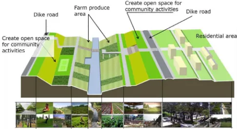
ÁRRGRIDVWKHEDVHÁRRG$WWKHKHLJKWRIWKHÁRRGWKH HQWLUHGHOWDZDVÁRRGHGWRDQDYHUDJHKHLJKWRIURXJKO\P 8QGHUFRQGLWLRQVVXFKDVWKLVIXUWKHULQÀOOLQJRIWKHÁRRGSODLQ can only take place alongside improvements in drainage. 'HVSLWHLWҋVKLVWRU\RIÁRRGLQJWKHORZHU+D7KDQK5LYHU delta’s relatively small size and 8 m slope create opportunities to construct a multifunctional space that provides room for urban growth while also preserving room for rivers in reserved ÁRRGZD\VWKDWFDQDOVREHXVHGIRUDJULFXOWXUHDTXDFXOWXUH and recreation. The concept design illustrated below is based on recommendations in this report. It is not a completed plan, but rather, using an overlay method that makes use of available data and a set of principles, it presents a logic for XUEDQL]DWLRQDQGÁRRGPDQDJHPHQWWKURXJKYLVXDOL]DWLRQ7KH concept design follows these principles:
% UHGXFHWKHULVNRIÁRRGLQJE\FUHDWLQJPXOWLIXQFWLRQDO DUHDVWKDWDOORZÁRRGZDWHUWRVSUHDGRXWHYHQO\DFURVV
the delta as it passes into Thi Nai lagoon;
% limit the need to resettle people living in existing villages by identifying buildable areas through a combination of
DWRSRJUDSK\EK\GURORJ\DQGFUHFHQWVHWWOHPHQW
history;
KWWSZZZVFLHQWLÀFDPHULFDQFRPDUWLFOHFIP"LG KRZWKHGXWFKPDNHURRP
% accept that new and ongoing construction in the
ÁRRGSODLQKDVEHFRPHSDUWRIWKHODQGVFDSHRIWKHGHOWD
and will need to be accommodated where possible and
PRGLÀHGZKHUHQHFHVVDU\
% create new spaces for urbanization primarily through
LQÀOOLQJDQGH[SDQVLRQRIH[LVWLQJVHWWOHPHQWDUHDVUDWKHU WKDQÀOOLQJDJULFXOWXUDOODQG
% LPSURYHGUDLQDJHE\GUHGJLQJH[LVWLQJÁRRGFKDQQHOV
and creating new channels through low-lying areas;
% limit the need for construction of new dike roads by building on existing roads wherever possible;
% widen bridges to the fulest extent possible in order to improve drainage and reduce overtopping of existing roads; and
% limit construction outside the eastern dike. This area
VKRXOGEHSUHVHUYHGDVDQRSHQÁRRGSODLQHFRORJLF ]RQHDQGÀUVWGHIHQVHDJDLQVWVHDOHYHOULVH
F I G U R E 5A AND 5B
F I G U R E 5C AND 5D
0DSLGHQWLÀHVÁRRGFKDQQHOVDQGEXLOGDEOHDUHDVZLWKRXW WKHHOHYDWLRQDQGÁRRGLQJOD\HUVLQSUHYLRXVVHULHV,PSURYLQJ drainage is the key requirement without which further
urbanization of the delta is not recommended. To do this, bridges should be widened as much as possible. There is no need to economize here. Opening space for water to pass through the rail line, Highway 19, Hung Vuong Street and Tran Hung Dao Street is insurance against overtopping. Since it is impossible to construct homes and businesses on bridges, it is also a form of preserving these open channels. An Phu Thinh should be reduced to roughly half its size, leaving the DUHDQRUWKRI%DUUDJHRSHQDQGOHDYLQJURRPIRUÁRRGZDWHU to spread outside the dike between Barrages 1 and 2. If improved drainage in northern Nhon Phu and Nhon Binh can UHGLUHFWÁRRGZDWHUDZD\IURPVRXWKHUQ1KRQ3KXLWPD\ be possible to create a residential area south of Tran Hung Dao Street. This will require further hydrological analysis. For now, we have removed this residential area to create more VSDFHIRUÁRRGZDWHU$GGLWLRQDOVHWWOHPHQWVSDFHLVDYDLODEOH
in Lac Truong, in northern Nhon Binh where the Kon and 7UXRQJ8F5LYHUVPHHW+RZHYHUÁRRGZD\VZLOOQHHGWREH maintained here to allow for overtopping the northern dike. In ÁRRGZDWHURYHUWRSSHGWKHGLNHLQSODFHVLQGLFDWHGLQWKH design. New construction in Van Ha will need to be set back from the dike both to leave space for overtopping the dike and to protect homes from potential damage. This area can be used as park space.
7KHSKRWRVÀJXUHVDQGWH[WEHORZRIIHUVRPHLGHDVIRUÁRRG channel restoration and urban development compatible with this conceptual design.
2XUÀUVWH[DPSOHLVWKH.DOODQJ5LYHU5HVWRUDWLRQ3URMHFWLQ Singapore.4 This project, which replaces a concrete drainage
FDQDOKDVWUDQVIRUPHGDVHDVRQDOÁRRGZD\LQWRDUHFUHDWLRQDO DUHD'XULQJGU\ZHDWKHUULYHUÁRZLVFRQÀQHGWRDQDUURZ VWUHDPLQWKHPLGGOHRIWKLVELRHQJLQHHUHGÁRRGZD\7KH gently sloped riverbanks form part of the park features, and park users are able to walk along the water’s edge. In the HYHQWRIDVWRUPWKHZDWHUOHYHOLQWKHULYHUFDQULVHWRÀOOWKH ÁRRGZD\DVLWGLVFKDUJHVLQWRWKHVHD$WWKHFRDVWDQHZ
4 http://www.pub.gov.sg/abcwaters/Publications/Pages/KallangRiver.aspx
P H OTO 4
barrage has been built at Marina Bay to store fresh water from the Kallang River or human consumptions. The river thus SURYLGHVDUHFUHDWLRQDODUHDDPHDQVRIUHGXFLQJÁRRGLQJDQG a fresh water source within the city.
Our second example is in Danang. In 2012, Skidmore, 2ZLQJV 0HUULOO//3620ZDVDZDUGHGWKHPDVWHU planning commission for a sustainable community on the Cu De River in Danang. Covering an area of 180 hectares, the plan is organized as a series of districts, including a Town Center, a Business District, and a series of residential neighborhoods. SOM’s concept is based on the key principle of reducing energy needs and carbon emissions by promoting best practices in mixed-use development. The design also PDLQWDLQVDQGLPSURYHVÁRRGZD\VWKURXJKFUHDWLRQRISDUNV and wildlife protection areas. New residential and other urban DUHDVDUHSURWHFWHGIURPÁRRGLQJE\XVHRIÁRRGZD\VDQG natural elevation. The developers believe that by improving the ÁRRGZD\VDQGORFDWLQJUHVLGHQFHVRQKLJKHUHOHYDWHGODQG WKH\ZLOOEHDEOHWRSUHYHQWÁRRGLQJLQUHVLGHQWLDODUHDVXSWR \HDUÁRRGV5 This extreme standard has been used
due to the uncertainties of climate change.
Our third example is from Hanoi. Floodways can be used for more than recreation and wildlife protection. In many cases, ÁRRGZD\VDUHDOVRUHVHUYHGDUHDVIRUDJULFXOWXUH,Q+DQRL for example, bananas, herbs, and corn are grown in the VHDVRQDOO\ÁRRGHGDUHDRIWKH5HG5LYHUDQGLQWKHFLW\ҋV PDVWHUSODQDQGWKHÁRRGZD\RIWKH'D\5LYHULVUHVHUYHG for agriculture.6 A proposed master plan for Can Tho City
FUHDWHVVLPLODUDJULFXOWXUDODUHDVZLWKLQÁRRGZD\V8UEDQ farming will become important as food prices rise due to rising temperatures, drought and energy costs.
Many of the farmers we talked to in Nhon Phu and Nhon Binh said they would agree to resettle in new urban areas if they could keep part of their farmland. For some, this was a lifecycle
KWWSZZZ\RXWXEHFRPZDWFK"Y U+OKB&&;N
/XX'XF&XRQJ5HVSRQGLQJWRQDWXUDOKD]DUGVDQGFOLPDWHFKDQJH
LVVXH²WKH\DUHVLPSO\EH\RQGWKHDJHRIHPSOR\PHQWLQWKH city’s industrial zones. For others it was a lifestyle choice. Right now, Quy Nhon offers its residents the possibility of living on a small farm while one or more family members work in urban and industrial areas. This allows families to combine income from various sources, which keeps wages down while also providing families with food security. Encouraging urban agriculture is considered to be an important climate adaptation strategy for cities worldwide, by providing diverse food sources in times of local or global shortage.7 It also
creates an opportunity for urban planners to create agricultural ]RQHVZLWKLQWKHFLW\ҋVÁRRGSODLQV'HWHUPLQLQJZKHUH
and how to create these agricultural spaces will take time, public participation, and coordination between several city departments.
Ms. Truong Thi Thau offered us some suggestions on how a transition from village to city might take place.
Suppose the government cuts a part of my rice land to build a new urban area. In my example, … everyone would
$FKDU\D$+RRUQZHJ'DQG'XEEHOLQJ8UEDQ$JULFXOWXUHLV
Climate Smart. In Axel Baeumler, Ede Ijjasz-Vasquez, Shomik Mehndiratta
(GVSustainable Low-Carbon City Development in China. Washington: The World Bank.
F I G U R E 6
F I G U R E 7
RESTORING THE DAY RIVER FLOODWAY
VDFULÀFHDOLWWOHLQRUGHUWRFRQVROLGDWHODQGVRWKDWZHFDQ all have a proper life together in that new urban area.
I am quite willing to live in a new urban area as long as some land is reserved for agriculture…This would be a consolidated area where we would be able to manage, to FRQWUROGLVHDVHVWRNHHSWKHHQYLURQPHQWFOHDQ²,ZRXOGQRW raise animals in a residential area.
This option is good, clean and beautiful.
I have longed for that kind of life, and now that I am older, I still wish for that, because it is clean.
of central Vietnam killing 122 people and causing $280 million in damage to property. While typhoons strike Vietnam each fall, the severity of this storm caught both meteorologists and local disaster relief professionals off guard. Storms like Mirinae are infrequent, but not unusual. Many have struck the coast of Central Vietnam in the past and, according to climate scientists, many more will do so in the future. Both citizens and the state are well aware of these seasonal risks and attempt to prepare for them before each storm season. Given this, the extent of damage and loss of life associated with typhoon Mirinae might come as a surprise.
Our task in this research was to analyze the causes of typhoon Mirinae’s severity and, using approved scenarios for climate change, assess the potential impacts resulting from implementation of the Area Plan for Nhon Binh to 2020.
The Institute for Social and Environmental Transition-International www.i-s-e-t.org/Vietnam
Ngo Thi Le Mai [email protected]