Geochemical of Soil
at Gedongsongo Geothermal Prospect Area
T. Listyani R.A.1 and Ev. Budiadi 11Department of Geological Engineering, Sekolah Tinggi Teknologi Nasional Yogyakarta [email protected]
Abstract
Gedongsongo geothermal prospect area is located in Ungaran, Semarang Regency, Central Java. Various geothermal manifestations appeared in the area, such as warm ground, hot spring, rock alteration and fumaroles. Geothermal phenomena is interesting to study, especially on the geochemistry of soil, to see the relationship with geothermal activity. Objective of this study is to determine geological structure and their relationship with geothermal systems by analysis the appearance of some chemical elements in soil. Method of the study were geological and geochemical field study, accompanied by soil sampling. Value of CO2 of soil were taken directly in field, while
H2O and Hg (mercury) content were determined in the laboratory. Soil geochemistry testing of
research area performed by looking at the levels of CO2, H2O and Hg. These three compound
anomalies occur in several places, indicating closures around Gedongsongo area. This indication is interpreted closely related with rim structure formed by faults encircling Gedongsongo area.
Key words: : geochemistry, soil, mercury, Gedongsongo
1. Introduction
Java Province, including one of the very prospect of the existence of geothermal energy, this is indicated by the amount of Quaternary volcanic spread in the region of Central Java province, for example, Mt. Ungaran, Semarang District. Geothermal manifestations of this mountain can be found mainly in Gedongsongo area. Manifestation is shown, among others, in the presence of warm ground, hot springs, fumaroles, rock alteration and so on.
Gedongsongo geothermal prospect area is located in Ungaran, Semarang regency, Central Java (Figure 1). Administratively, this area was included in the District of Bawen, Bandungan and Ambarawa. Geographically the research areas included in the map RBI Digital Indonesia, Sheet 541 (Sumowono) and Sheet 1408-542 (Ungaran) scale of 1: 25,000, published by the Bakosurtanal (2001). Regionally the research areas included in the Geological Map Sheet Magelang and Semarang, scale 1: 100,000, published by the Geological Research and
Development Centre, Bandung (Thanden et
al,1996).
Gedongsongo area occupies the area at an altitude of approximately 1300 m above sea level, and is located on the southern slopes of Mount Ungaran, one of the Quaternary volcanoes located in Central Java Province. The research area has undulating to hilly morphology, where some places are tourist areas and forestry.
Figure 1. Location of research area.
On of some geothermal problem is its geological structure. The aim of this study is knowing the geological structure by analysis of chemical compound contents of soil. The geochemical study usually helpful for geological structure study, especially for determining some minor structures.
One of the interesting things in the area to be studied is the geochemical characteristics of soil which certainly influenced by the geothermal activity in the area. Geochemistry of soil can supported the interpretation of geological
structure in order to know about geothermal system.
2. Methods
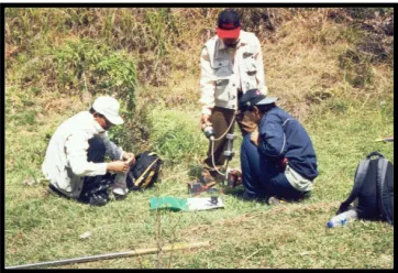
Geochemistry of soil in geothermal prospect areas studied by the chemical data of three compounds i.e. CO2, H2O and Hg (mercury) obtain from soil. These chemical data obtained as the results of the geological survey field from Central Java Mining & Energy Agency and STTNAS, project in 2004. Soil sampling have been carried out directly in the field. Analysis of the three soil chemistry is useful to determine geological structure of geothermal prospect area. Geochemical of soil have been investigated by analyzing the content of H2O, CO2 and mercury (Hg) of soil. Determination of the amount of CO2 is done directly on the ground in the field while the content of H2O, and Hg were analyzed in the laboratory BPPTK Yogyakarta from 70 soil samples (Anonim, 2004). The field work is shown in Figure 2).
Figure 2. Sampling and soil testing in field.
3. Regional Geology of Gedongsongo
The research area is located in the area and surrounding Ungaran, Central Java. The area is included in the regional physiographic Zone Kendeng (Van Bemmelen, 1949). This zone has been incorporated in the physiographic Antiklinorium Bogor - North Serayu - Kendeng. The landscape of Mt. Ungaran is a volcanic cone morphology, hilly areas and the expanse of volcanic plains region. Volcanic cones occupies most of the study area, especially in the middle. This cone morphology composed by series of andesitic volcanic rocks consisting of lava, sandstone, volcanic breccia and andesite. Stratigraphically complex of Mt. Ungaran map based regional geological sheet of Magelang and Semarang (Thanden et al, 1996), can be classified into five groups: (1) Tertiary Rocks Group consisting of Kerek Formation (consists of intercalation of claystone, marl, tuffaceous sandstone, conglomerates, volcanic breccias and
limestone), Kalibeng Formation (consists of marl with intercalation of sandstone); (2) Quaternary Sedimentary Rocks Group covering Kaligetas Formation (consists of volcanic breccias, lava, tuff, tuffaceous sandstone, and claystone), Damar Formation (composed by tuffaceous sandstones, conglomerates and volcanic breccias), Jongkong Formation (composed of andesite breccias; (3) Flow Quaternary Rocks Group composed by Kaligesik Volcanic Rock (consists of olivine-augite basalt lava flows), Gajahmungkur Volcanic Rock (composed of andesite-hornblende lava flows), Sumbing lava (composed by lava flows and dome), (4) Intrusion rocks composed of augite basalt and andesite intrusion; and (5) Alluvial composed of loose rock in clay to boulder grain size.
4. Overview of Geothermal Gedongsongo
Geothermal manifestations at Gedongsongo indicate the prospects for development in the direction of exploration. It is supported by the existence of geothermal manifestations such as fumaroles (89,7oC), hot springs (temperature ranging 61,4oC - 71,6oC), warm springs (temperatures ranging from 45oC - 46oC), boasting gas (gas bubble) measurable ranges 33oC - 37oC and rock alteration in the form of argilit (Anonim, 2004).
Geothermal manifestations in Gedongsongo area consists of fumaroles, hot springs, hot springs, boasting gas (gas bubble) and rock teralterasi. Gedongsongo included in Bandungan subdistrict, Semarang regency. This region occupies a height of approximately 1300 m above sea level and is located on the southern slopes of Mt. Ungaran. Temperatures in this region 24,9o C. geothermal manifestations in this area is located along the river are relatively straight with directions N 5o E. Joints can be found at directions of N100oE / 70o. Fumaroles appear at the valley and the western part of the river canyon and has a gas blowing relatively constant with temperature 89,7o C (Anonim, 2004).
The hot springs have turbid and muddy water with gray color , occupying the part of the river valley western and eastern parts. The springs temperature ranges 61,4oC - 71,6oC. warm springs have turbid water and a little muddy with mud gray color, occupies the eastern part of the valley. Temperatures range from 45oC - 46oC. bluff gas indicated by the discharge of gases on the surface of the water and the rock bottom that is located in the south pass through small
fractures-fractures. This gas boasting
springs are the deposition of yellow sulphur (Anonim, 2004)..
Rock alteration occupies at the valley until the top of the river bank with the spreading of approximately 30 m, blackish-grey color. Type of alteration of rocks in this area are generally in the form of argilitization. This alteration regarding the volcanic rocks are breccias and lava (Anonim, 2004).
5. Discussion
Relatively high Hg anomalies are characteristic of a structure associated with geothermal water source (Capoana and Rampord, 1976, in Trend Team Jawa – IBT, 1997). It was stated that the geothermal activity beneath the surface reflected by anomalous Hg has close links with the fault.
Appearances of Hg and CO2 is strong controlled by faults because Hg is transferred to the surface by the difference in temperature from the earth through weak zones. Anomalies both elements provide indications of potential hydrothermal. Van Kooten (1987) suggest that shallow, soil-mercury surveys can be used effectively in exploration for geothermal resource. Mercury data can significantly enhance the structural understanding of prospect area of geothermal. Moreover, it can yield important information about geothermal resource. It means that by mercury data, some prospect areas of geothermal can be interpreted. Even, it can be effective in identifying drilling targets (Matlick & Shiraki, 1981).
Hg concentrations in the soil studied had an average price of 122.74 ppb. Anomalies occur in northwest area of Gedongsongo. This anomaly is thought to occur due to the fault that encourages discharge of hydrothermal solutions that result in the accumulation of sediment Hg considerable ground.
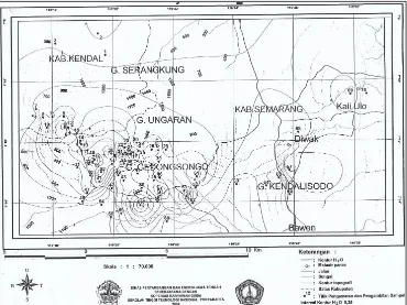
CO2 anomaly found in some observation stations with the maximum concentration more than 250%. The anamaly areas are also clear located at northwest of Gedongsongo manifestation area.
H2O anomaly encountered in some stations by 12.62%, 12.56% and 12.02%. Compared with others elements, the H2O anomaly is almost unclear, and spread into some places. However, this anomaly still supported for evaluating minor structures.
Some geologic structures which are quite intensive in a geothermal field can serve as a medium or hot spring outlet (Risdianto & Kusnadi, 2017). This can be characterized by the
presence of high anomalies of both Hg and CO2 values. The appearance of mineral anomalies Hg and CO2 is controlled by the presence of fault structure. At the intersection of several faults there may be a reserve that allows the accumulation of geothermal fluid. Thus, the presence of fluids that cause accumulation of Hg and CO2 in the soil can be used to localized the geothermal prospecting zones. According to this statement, Gedongsongo and its surrounding area may have some both major and minor faults.
Map of the distribution of Hg concentrations, CO2 and H2O shows the closure in several places around the area Gedongsongo (Figure 3-6). This indication is interpreted is closely linked to the rim structure in the form of fault circling Gedongsongo area.
In order to evaluate the suitable of the soil mercury geothermal survey as a geothermal exploration technique, soil concentrations of mercury are compared to the distribution of measured geothermal gradients (Matlick & Shiraki, 1981). Zones containing high-mercury values are found to closely correspond to high geothermal gradient zone. Moreover, the highest mercury values within the anomalies are usually found near the wells with the highest geothermal gradient. Unfortunately, there was only one exploration well of shallow depth which have been conducted in at Gedongsongo (Anonim, 2005).
6. Conclusion
Geochemistry of soil in the area of geothermal prospects Gedongsongo influenced by the geothermal activity. Geochemistry of soil performed by looking at the levels of CO2, H2O and Hg (mercury). Hg concentrations in the soil at Gedongsongo have an average value of 122.74 ppb, with an anomaly occurs in the northwest Gedngsongo. CO2 anomaly found in some observation stations with the maximum concentration as >250% in the west Gedongsongo. Map of the distribution of Hg, CO2 and H2O concentrations show the closure in several places around the area Gedongsongo. This phenomena is interpreted as rim structure that closely related to faults encircling Gedongsongo area.
Acknowledgement
Reference
Anonim, 2004, Pengembangan Pemanfaatan
Energi Panas bumi (Survei Geokimia) di Kompleks Panas bumi Gedongsongo, Kabupaten Semarang, Central Java Mining & Energy Agency – STTNAS Final Report, unpublished.
Anonim, 2005, Survai Landaian Suhu di
Kompleks Panas Bumi Gedongsongo, Kabupaten Semarang, Central Java Mining & Energy Agency – Geomap, Final Report, unpublished.
Bakosurtanal, 2001, Topographic Map of
Indonesia, Sumowono Sheet, No. 1408-541, Bakosurtanal, Cibinong.
Bakosurtanal, 2001, Topographic Map of
Indonesia, Ungaran Sheet, No.1408-542, Bakosurtanal, Cibinong.
Budiardjo, B., Nugroho dan Budihardi, M., 1997, Resources Characteristics of the Ungaran Field, Central Java, Indonesia, Proceeding of National Seminar of Human Resources Indonesian Geologist, Yogyakarta.
Matlick, J.S. and Shiraki, M., 1981, Evaluation of The Mercury Soil Mapping Geothermal
Exploration techniques, https://www.
researchgate.net.
Risdianto, D. and Kusnadi, D., Aplikasi Grafik Probability dalam Pengolahan Data
Eksplorasi Panas Bumi,
http://psdg.bgl.esdm.go.id
Thanden RE., Sumadirdja H., Richard PW., Sutisna K. dan Amin TC., 1996, Regional Geological Map of Magelang dan Semarang Quadrangle, scale 1 : 100.000, Pusat Penelitian Dan Pengembangan Geologi, Bandung.
Trend Team Jawa – IBT, 1997, Prospek Panas Bumi Daerah Ungaran Jawa Tengah, Geothermal Exploration Agency – Pertamina, Jakarta.
Van Bemmelen, R.W., 1949, The Geology of Indonesia, Vol. 1A, Martinus Nijhoff, The Hague, Netherland.
Van Kooten, G.K., 1987, Geothermal Exploration using Surface Mercury Geochemistry, Journal of Volcanology and Geothermal Research, Vol. 31, Issues 3-4, April 1987, Pages 269-280.
Figure 4. Distribution map of CO2 (Anonim, 2004).