A RESEARCH ON SPATIAL TOPOLOGICAL ASSOCIATION RULES MINING
Jiangping Chen 1, Song Liu 1, Penglin Zhang1, Zongyao Sha1
(1 School of Remote Sensing and Information Engineering ,Wuhan University ,
129 Luoyu Road ,Wuhan ,China ,430079)
Commission II, WG II/3
KEY WORDS: Geography, Research, Data mining, GIS, Algorithms
ABSTRACT:
Spatial association rules mining is a process of acquiring information and knowledge from large databases. Due to the nature of
geographic space and the complexity of spatial objects and relations, the classical association rule mining methods are not suitable
for the spatial association rule mining. Classical association rule mining treats all input data as independent, while spatial association
rules often show high autocorrelation among nearby objects. The contiguous, adjacent and neighboring relations between spatial
objects are important topological relations.
In this paper a new approach based on topological predictions to discover spatial association rules is presented. First, we
develop a fast method to get the topological relationship of spatial data with its algebraic structure. Then the interested spatial objects
are selected. To find the interested spatial objects, topological relations combining with distance were used. In this step, the frequent
topological predications are gained. Next, the attribute datasets of the selected interested spatial objects are mined with Apriori
algorithm. Last, get the spatial topological association rules. The presented approach has been implemented and tested by the data of
GDP per capita, railroads and roads in China in the year of 2005 at county level. The results of the experiments show that the
approach is effective and valid.
0. INTRODUCTION
Spatial association rules mining is a technique which mines the
association rules in spatial databases by considering spatial
properties and predicates[1,2,3]. One important problem is how to get those spatial relations that compose the spatial properties
and predicates from the spatial objects, and translate the
non-structured spatial relations to structural expression so that
they can be mined with the non-spatial data together. There are
many researches about spatial association rules mining,
Algorithm ARM involving the spatial relations such as
direction, distance and topology has been well discussed in
some literatures[2,4–7], whereas Fenzhen Su[8] centered on using spatial difference to express how spatial relations affect the
interested spatial association rules we can get.
As spatial topological relation is one of the most important
spatial relations, many literatures about spatial association rules
mining fasten on it and presented many ways to get the
topological relation, such as RCC (Region Connection
Calculus), the classical MBR (minimum bounding rectangle),
9-intersection model. Ickjai Lee etc. Compared different RCC
models’ efficiency when used to get topological relations of a group of objects. MBR is a fast method to get the rough
topological relations, so it is often used with other precise but
expensive means. Eliseo Clementini etc.[3] put forward a method mining the spatial objects with uncertainty which uses
the objects with a broad boundary to take the uncertainty of
spatial information into account. The topological relations
between objects with broad boundaries is described by
9-intersection which can be concisely represented by a special
3×3 matrix and can distinguish 56 kind of topological
relations between objects with broad boundaries. All those
methods have a common problem when extracting topological
relations, they are very time consuming.
Paralleled to the concept of algebraic structure in
axiomatic system of set theory, topological structure has
continuously been the organization of spatial data in GIS, such
as the typical data format of ArcInfo--Coverage and the new
data model after ArcInfo 8--Geodatabase. Both algebraic
structure and topological structure can express topological
relations. For the reason that algebraic structure is the
topological connected effect however the spatial data changes.
Nevertheless, topological structure possesses multilayer
dependence, leading to the reconstruction of topological
structure when spatial data changes, which is disastrous to the
maintenance of magnanimity data.
In this paper, a new approach based on topological
predications gaining by algebraic structure of spatial graph to
discover spatial association rules is proposed.
1. MATERIALS AND STUDY AREA
This paper deals with China region, which has been mapped at
1:4,000,000 scale. All the data are downloaded from Data
Sharing Infrastructure of Earth System Science
(http://www.geodata.cn/Portal/?isCookieChecked=true) of
China.
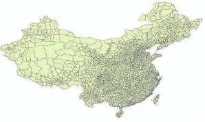
As an indicator of a country's standard of living, GDP per
capita is regarded as a kind of attribute data and represented by
polygons in the level of county(figure 1), summing up to 3406
polygons.
Figure 1. Counties with GDP per capita attribute in China
Railroads and roads are the most significant means of
ground transportation. This paper selects arterial railroads and
roads with massive freight and passenger transportation in
China(figure 2).
Figure 2. Railroad and road data in China
2. METHODS
2.1 Definitions
Definition 1 (Unit) According to theory of cell structure proposed by J.Corbett[9], spatial feature should be divided into point, line, surface and volume. For instance, roads are directed
lines and buildings are polygons. For the reason that polygon is
made up of line, and point can be regarded as degraded line,
line unit algebraic structure is the most basic as well as
significant content in this paper.
Definition 2 (Permutation) Suppose domain X represents index
set (+1, -1, +2, -2, ···, +n, -n), and unit variable
x
X
is given, then expression y=a(x) is the permutation of x under theprecondition of
y
X
[10] .Definition 3 (Involution) Involution can be seen as a particular case of permutation, if y=a(x)=a[a(x)]=x came into existence,
this particular permutation would be called involution.
Definition 4 (Zero-order permutation
a
0(x) ) Zero-orderpermutation is defined as the transformation from unit variable
+x to -x or from -x to +x based on the concept of involution.
Zero-order permutation gives a line with direction +x to -x.
Definition 5 (First-order permutation
a
1(x)) First-orderpermutation records all the adjacent line units in
counterclockwise order. First-order permutation gives the
expression of point with all its crossing lines.
Definition 6 (Algebraic Structure) Based on the concepts and
idea above, the expression {X ,
a
0(x),a
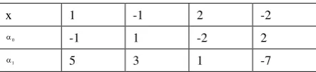
1(x)} is called the algebraic structure of spatial graphic.2.2 Construction of Topological Relation from Algebraic Structure
Taking line graphic in figure 3 as an example, the process of
producing line unit algebraic structure expression can be
divided into two steps. The first step is the unitization of spatial
graphic, at the same time, the unitized result needs numbering
in the same order with unitization to constitute index of unit
variables X. The fundamental principles of unitization are
there must not exist any point unit in the middle of any line
unit;
line units are not allowed to cross with each other.
Then the second step is producing zero-order permutation
0
a
(x) and first-order permutationa
1(x) withx
X
, astable 1 shows. In order to save memory space,
a
1(x) isrecorded as the nearest adjacent line unit in the
counterclockwise rotation searching, instead of all the adjacent
line units. For instance, line unit 1 rotates in counterclockwise
order with P1 as pivot, and gets
a
1(1) =5, while line unit -1rotates in counterclockwise order with P2 as pivot and gets
1
a
(-1) =3.Figure 3. Sample line graphic
x 1 -1 2 -2
0
-1 1 -2 2
1
5 3 1 -7
Table 1. Part of line unit algebraic structure of Figure 3
From the line unit algebraic structure could we get
topological relation easily by different combination of
zero-order permutation
a
0 (x) and first-order permutation1
a
(x). Let us take intersecting relation for instance, since wehave combined polygon layer with line layer into one line layer,
this intersecting relation of polygon and line can be treated as
adjacency relation of lines with two kind of attribute. Suppose
L(x) = {x,
a
0(x)} = {x, y} is the given line, we are able toelicit the adjacent lines R(L) by
N(x) =
a
1(x) = (x
0,x
1,···,x
n );N(y) =
a
1(y) = {y
0,y
1,···,y
n};R(L) = {(
x
0,a
0(x
0)), (x
1,a
0(x
1)),···,(
x
n,a
0(x
n)), (y
0,a
0(y
0)),(
y
1,a
0(y
1)),···,(y
n,a
0(y
n))}[10].Since the topological relation is represented as functional
relation of units, the topological operation upon given unit will
only affect adjacent units. Therefore, the method of
representing topological relation by line unit algebraic structure
can effectively eliminate the phenomenon of data linkage and
topological redundancy, bringing the improvement of spatial
analysis efficiency.
2.3 Association Rules Mining
The topological relation matrix in part 2.2 is regarded as
waiting mining transaction database, and needs inspection.
Representing the topological relation by line unit algebraic
structure and qualitatively storing the result render this spatial
relation can be processed in the same mining way with attribute
data. This step is to complete association rules mining with
typical Apriori algorithm, based on the given minimum support
and minimum confidence. Apriori algorithm is a primary
algorithm of mining association rules of attribute, aiming at
finding out relation among items of a data set.
3. EXPERIMENTS
In order to reduce the recorded points as well as display the
graph more clearly, one step before construction of algebraic
structure is to simplify the polygons by Point Remove
algorithm, which is a fast, simple algorithm that reduces a
polygon boundary quite effectively by removing redundant
points. A relatively sketchy outline is precise enough and
shows the visualization of simplified polygons of GDP per
capita source data.
Figure 4. Simplify polygon
After the preprocessing such as filling out incomplete
data and noise treatment, the next step is unitization and
numbering. Based on the principles and multi-layer
characteristic of GIS data, we overlay layers into one, for
example, the railway layer and county layer is combined into
one line layer in figure 5. Then we treat all the features as lines
and split these lines wherever exits a point. For the reason that
the source data has no direction, we unitize the line unit with
random direction, which is splitting every line into '+' part and
'-' part randomly. At the same time, uniquely number the line
units and organize the index of unit variables X like (+1, -1, +2,
-2,···, +n, -n).
Figure 5. Unitization and numbering
From the numbering graphic and index of unit variables
X could we produce zero-order permutation
a
0 (x) andfirst-order permutation
a
1(x). For instance, the originalrailway layer is represented like figure 6, while GDP per capita
layer seems more complex as figure 7 shows.
Figure 6. Line unit algebraic structure-railway
Figure 7. Polygon unit algebraic structure-GDP per capita
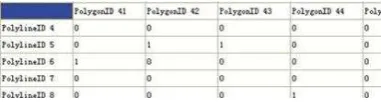
By means of algebraic structure in figure 6 and 7, we can
easily derive the basic topological relation matrix like figure 8
with acceptable operation time like figure 9.
Figure 8. Topological relation--intersecting matrix
Figure 9. Operation time
In order to apply association rules mining algorithm,
firstly we need to generalize the continuous attribute--GDP per
capita data. For the specific experiment, generalizing the GDP
per capita data into three levels based on its value, that is, the
upper third of GDP per capita in the order from the most to the
least is "high", the middle third is "medium" and the rest is
Using generalized GDP per capita data as consequent of
rules, and using intersecting relation between county and
railroad as well as intersecting relation between county and
road as antecedent of rules, we can apply typical Apriori
algorithm to mine associate rules.
4. RESULTS AND DISCUSSION
Since the original GDP per capita data has nearly 3000
polygons, it is painful to deal with its topological operation in
the ESRI ArcObject or ArcEngine, taking no account of speed
optimization like gaining index. Nevertheless, taking
intersecting matrix as an example, algebraic structure could
construct intersecting matrix in approximately ten seconds, and
deal with topological operation, for example, adding, removing
and modification, in less than one second.
With minimum support 10, we could get the mining
results, which are mostly omitted here due to page limitation. It
can be seen that GDP per capita of counties with railway and
highway simultaneously crossing is universally higher, and
these railways and highways are usually main artey of
communications, connecting diverse regions all around the
country. Through setting the minimum confidence as 0.8 could
we filter the frequent 3-itemsets and get the filtered result in
Table 2. Filtered result of frequent 3-itemsets
After further analyzing the filtered result, we find that
these railways and highways are built relatively earlier, and
they remarkably stimulated the economic development of
perimeter zone and even the whole nation. Therefore, the
mining result shows that railroads and roads could drive the
economic growth of circumjacent counties and cities. This
conclusion fits the fact and proves that the mining result is
believable.
5. CONCLUSIONS
It can be concluded that the brand new method to organize
spatial data based on algebraic structure can deal with
topological relation effectively and efficiently, for either
topological construction or maintenance. Furthermore, the
association rules mining results based on it are believable.
However, there still are a few problems should be
considered. Even though the process of constructing
topological relation from algebraic structure costs little time,
the efficiency of constructing of algebraic structure of mass
data needs further studies. Moreover, the containing relation is
not optimized in the algebraic structure.
6. ACKOWLEDGEMENTS
This study was supported by the National Science and
Technology Pillar Program during the Twelfth Five-Year Plan
Period (No. 2012BAJ15B04) and the National Nature Science
Foundation of China (No. 40801152, No. 61172175 and No.
41071249).
7. REFERENCES
[1] Mennis J, Guo D. Spatial data mining and geographic
knowledge discovery—An introduction. Computers, Environment and Urban Systems, 2009, 33(6), pp.403-408.
[2] Fang G, Xiong J, Tu C. An algorithm of mining spatial
topology association rules based on Apriori. Intelligent
[3] Clementini E, Di Felice P, Koperski K. Mining
multiple-level spatial association rules for objects with a broad
boundary. Data & Knowledge Engineering, 2000, 34(3),
pp.251-270.
[4] Gongquan L, Keyan X. Spatial Data-mining Technology
Assisting in Petroleum Reservoir Modeling. Procedia
Environmental Sciences, 2011, 11, pp.1334-1338.
[5] Birant D, Kut A. ST-DBSCAN: An algorithm for
clustering spatial–temporal data. Data & Knowledge Engineering, 2007, 60(1), pp.208-221.
[6] Estivill-Castro V, Lee I. Clustering with obstacles for
Geographical Data Mining. ISPRS Journal of Photogrammetry
and Remote Sensing, 2004, 59(1-2), pp.21-34.
[7] Lee I, Qu Y, Lee K. Mining qualitative patterns in spatial
cluster analysis. Expert Systems with Applications, 2012, 39(2),
pp.1753-1762.
[8] Su F, Zhou C, Lyne V, et al. A data-mining approach to
determine the spatio-temporal relationship between
environmental factors and fish distribution. Ecological
Modelling, 2004, 174(4), pp.421-431.
[9] Corbett, 1985. A General Topological model for Spatial
reference, U.S.Census, pp.3-15.
[10] Jingshegn Z, Changqing Z, 2005. Algebraic
representation and morphological transformation of spatial