IJOG
Depositional Cycles of Muara Wahau Coals, Kutai Basin, East Kalimantan
Komang Anggayana1, Basuki Rahmad2, and Agus Haris Widayat1
1Research Group of Earth Resource Exploration, Faculty of Mining and Petroleum Engineering, ITB
Jln. Ganesha No. 10, Bandung
2Study Programme of Geology, Faculty of Mineral Technologies, UPN “Veteran” Yogyakarta
Jln. Swk 104 (Lingkar Utara), Condongcatur, Yogyakarta
Corresponding author: [email protected]; [email protected]; [email protected] Manuscript received: April 1, 2014, revised: May 12, 2014, approved: August 19, 2014
Abstract - Fifteen samples were taken ply by ply from a 33 m thick drill core of Muara Wahau coal seams for
in-terpretation of depositional environments. Generally, lithotype variation in the bottom part of the coal seams has a lower frequency than in the upper part. Petrographical analysis was performed to determine the maceral composition, groundwater index (GWI), and gelification index (GI). The samples from lower sections show much higher GWI-GI values and lower variation frequency than from the upper section. This characteristic is interpreted as the result of development of mesotrophic to ombrotrophic peats during the deposition of lower to upper parts of the section, re-spectively. During the development of the mesotrophic peat, water was more abundant and relatively stable in budget. However, during the development of ombrotrophic peat, water was less abundant and relatively not stable in budget. The latter is related to the water supply depending only on rain, resulted in the more sensitive water table in the om-brotrophic peat. The unstable water table is thought as the reason of higher variation frequency of lithotype, GWI, GI, as well as maceral composition in the upper part of the core. Unstable water table would lead to moist condition in the uppermost layer of the ombrotrophic peat, favoring fungi to grow. This is confirmed by the higher abundance of sclerotinite maceral in samples from the upper part of the coal core.
Keywords: coal seam facies, Muara Wahau, Kutai Basin
Introduction
Muara Wahau coals are part of Early Miocene Wahau Formation, Kutai Basin, East Kalimantan,
consisting of several thick coal seams. The thick
-ness of each seam is up to 60 m. The coal has not been disturbed by exploitation, as the site is located in a very remote area.
Peat accumulation is controlled by at least two
key factors: subsidence rate creating accommoda
-tion space and organic matter (trees) supply rate
(Taylor et al., 1998). The interplay between the
two factors in equilibrium state brings through peat accumulation. The longer equilibrium state
time is reached, the thicker peat would be accu
-mulated. Another important aspect is the presence of water which takes a role as media of nutrient
supply and deposited-organic matter preserva
-tion. Peat water may originate from groundwater, rain water, and intrusion of sea water. The peat water table is fluctuative and sensitive to season or climate changes. The hydrological condition in peats determined the vegetation and peat type accumulated in a basin.
In the present case, the Muara Wahau coals are interesting to investigate. The thick coal seams can provide more detailed indications of
chemical and physical changes during peatifica
-tion. With respect to hydrological condition, the succession of early development of Muara Wahau coals will be reconstructed and discussed in detail. Petrographical analysis was carried out to characterize the maceral composition of the Muara Wahau coals.
INDONESIAN JOURNAL ON GEOSCIENCE
Geological AgencyMinistry of Energy and Mineral Resources Journal homepage: h�p://ijog.bgl.esdm.go.id ISSN 2355-9314 (Print), e-ISSN 2355-9306 (Online)
IJOG
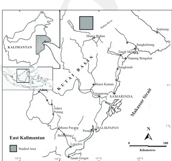
Geological SettingsThe studied area is located in Muara Wahau
Sub-regency, East Kutai Regency, East Kali
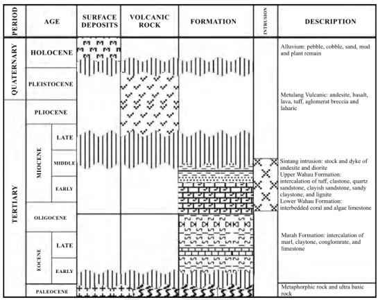
-mantan, Indonesia (Figure 1). The area is mostly composed of Early Miocene Wahau Formation according to Supriatna and Abidin (1995) (Figure 2). The formation was deposited in Upper Kutai
Basin (Calvert, 1999). The lower part of the for
-mation consists of interbedded coralline and algal limestones. The upper part of Wahau Formation comprises interbedded tuff, claystones, quartz sandstones, sandy claystones, and coal layers.
There are two major coal seams in the area (Fig
-ure 3), showing variation in the thickness from
15 to 62 m, with gentle dips that range from 8o
to 12o. The cropline distribution is controlled by
the presence of syncline in the area. Generally, the coals are blackish brown, hard, brittle, dull in luster, and contain resin and fossilized wood in some parts.
Methods
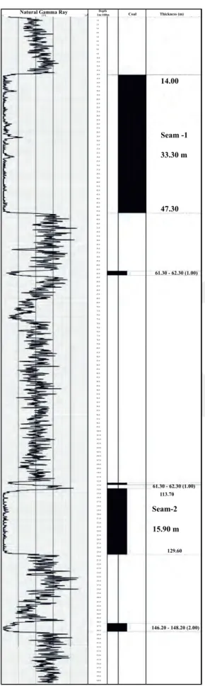
The study was commenced by collecting rep
-resentative samples from the coal field. Drilling programme, which was conducted, penetrated Seam 1 and Seam 2 in the coal field (Figure 4).
The selected coal samples were then taken di
-rectly ply-by-ply/ply sampling (Thomas, 2002) from Seam 1 core. The samples were separated based on the lithotype observed along the core,
then they were crushed and split for further labo
-ratory analysis.
For maceral composition, fifteen samples were investigated using Zeiss Axio Imager A2m polarized microscope in the Laboratory of Earth Resources Exploration, Faculty of Mining and Petroleum Engineering, ITB. During the maceral analysis, five hundred points with a minimum distance of 0.2 mm between each point were counted from the polished sections. The maceral composition is stated as percent (%-volume).
KALIMANTAN SAMARINDA Tenggarong BALIKPAPAN 0 100 o 1 S o 1 N o 0 N Sepinang Sangkulirang Tanah Merah Tanjung Bengalun Sangkinah Muara Kaman Adara Muara Payang Belimbing Studied Area Longikis Penajam Adara Pulung Muara Wahau Wahau River Telen River Tanah Grogot East Kalimantan Makassar Strait o 115 E 116 Eo 117 Eo 118 Eo K U T A I B A S I N Kilometres
IJOG
PE R IO D IN T R U SI O N AGE HOLOCENE PLEISTOCENE PLIOCENE M IO C E N E LATE LATE MIDDLE OLIGOCENE PALEOCENE E O C E N E EARLY EARLY DESCRIPTION FORMATION SURFACEDEPOSITS VOLCANICROCK
Q U A T E R N A RY T E RT IA RY
Sintang intrusion: stock and dyke of andesite and diorite
Upper Wahau Formation: intercalation of tuff, clastone, quartz sandstone, clayish sandstone, sandy claystone, and lignite
Lower Wahau Formation: interbedded coral and algae limestone Marah Formation: intercalation of marl, claytone, conglomrate, and limestone
Metaphorphic rock and ultra basic rock
Metulang Vulcanic: andesite, basalt, lava, tuff, aglomerat breccia and laharic
Alluvium: pebble, cobble, sand, mud and plant remain
Figure. 2. Regional stratigraphy of Upper Kutai Basin (Supriatna and Abidin, 1995). o 116 42'E o18'N o18'N o 116 44'E o110'N o110'N o 116 46'E o112'N o112'N o 116 48'E o114'N o114'N o 116 50'E o116'N o116'N o 116 42'E
Geological Map of Study Area o 116 44'E LEGEND : Tomw A B PMB-01-08 GT-03 GT-02 0 1 2 4 N Km
Coal Seam 1 Coal Seam 2Coal Seam 2
Wahau Fm Strike adn deep strata Sample location Sintang andesite intrusion Anticline, Syncline Coal Cropline Seam A Lineament River Coal Cropline Seam B
o
116 46'E 116 48'Eo 116 50'Eo
A B 0 0 100 100 m m Coal Seam 1 Coal Seam 2 ''
IJOG
Coal Thickness (m) 14.00 Seam -1 33.30 m 47.30 15.90 m Depth CPS 34 1.0 9.0 5.0 13.0 20.0 29.0 33.0 40.0 44.0 50.0 54.0 61.0 70.0 85.0 77.0 92.0 100.0 107.0 114.0 125.0 137.0 151.0 65.0 74.0 89.0 81.0 96.0 104.0 111.0 122.0 134.0 148.0 118.0 129.0 141.0 155.0 160.0 3.0 11.0 18.0 27.0 7.0 15.0 24.0 22.0 31.0 38.0 35.0 42.0 48.0 46.0 52.0 59.0 56.0 63.0 72.0 87.0 79.0 94.0 102.0 109.0 116.0 127.0 139.0 153.0 158.0 67.0 76.0 91.0 99.0 83.0 98.0 106.0 113.0 124.0 136.0 150.0 120.0 132.0 146.0 131.0 145.0 143.0 157.0 2.0 10.0 17.0 26.0 6.0 14.0 21.0 30.0 37.0 34.0 41.0 45.0 51.0 58.0 55.0 62.0 71.0 86.0 78.0 93.0 101.0 108.0 Seam-2 115.0 126.0 138.0 152.0 66.0 75.0 90.0 82.0 97.0 105.0 112.0 123.0 135.0 149.0 Natural Gamma Ray119.0 130.0 144.0 142.0 156.0 4.0 12.0 19.0 28.0 8.0 16.0 25.0 23.0 32.0 39.0 36.0 43.0 49.0 47.0 53.0 60.0 69.0 84.0 57.0 64.0 73.0 88.0 80.0 95.0 103.0 110.0 121.0 133.0 147.0 117.0 128.0 140.0 154.0 159.0 68.0 61.30 - 62.30 (1.00) 61.30 - 62.30 (1.00) 146.20 - 148.20 (2.00) 113.70 129.60 -1 1m:100m
Figure 4. Coal seam profiles (Seam 1 and Seam 2) from density log interpretations of Borehole GT-02.
Vitrinite (huminite) reflectance measurement was
also carried out in the Centre of Geological Re
-sources, Geological Agency, Ministry of Energy and Mineral Resources. Mean random vitrinite reflectance measurements were performed on the surface of vitrinite particles under oil immersion. Fifty points of vitrinite reflectance were taken on each sample. The identification and classification
of macerals in this study are based on ICCP Sys
-tem 1994 (ICCP, 1998, 2001, 2011), Suarez-Ruiz
and Crelling (2008), and Sykorova et al. (2011).
In order to investigate the hydrological regime of the ancient peat, two indices were determined.
Groundwater index (GWI) based on Calder et al.
(1991) was used to indicate the ratio of strongly gelified macerals (humocollinite), as well as the
mineral matter, to weakly gelified ones (humotel
-linite, humodetrinite). Mineral matter is considered to be related to water carrying detritral material to the former peat during flood (Crosdale, 1995).
GWI = Humocollinite + HumodetriniteHumocollinite + Minerals ...(1)
The second indicator used in this study is geli
-fication index (GI) based on Diessel (1986). GI is a tool to contrast gelified macerals to nongelified ones as the indicator of peat wetness. When the
peat is flooded by water, vitrinite and geloiner
-tinite tend to form. On the other hand, when the water table is lower and the peat surface becomes dryer or moist, teloinertinite and detroinertinite will form in the peat surface due to oxidation
(Lamberson et al., 1991)
GWI =Fusinite + Semifusinite + Sclerotinite + InertedotriniteHuminite + Macrinite
GWI and GI have different concepts. GWI changes reflect the fluctuation of water table which could happen in both high and low moor peat
types. In high moor, the water table would typi
-cally raise, following the development of rising peat surface. GI assumes that gelification process takes place in reduced water where the water table is static regardless of peat surface development.
The GWI could be correlated with GI on the development of peat as follows:
1. GWI < 0.5 and weak gelification (GI < 1) reflect lower water table of a marsh (Diessel,
IJOG
1986) and ombrotrophic peat type (Calder et
al., 1991).
2. GWI 0.5 - 1 and moderate gelification (GI ~
1) reflect higher water table of a fen? (Dies
-sel, 1986) and mesotrophic peat type (Calder
et al., 1991).
3. GWI > 1 and strong gelification (GI > 1) re
-flect higher water table of a wet forest swamp (Diessel, 1986) and rheotrophic peat type
(Calder et al., 1991). GI > 1 is characterized
by limited influx of clastics.
Result and Discussions Coal Lithotype
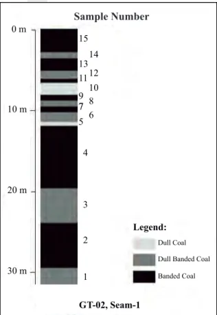
Lithotype classification used in this study is based on Stopes (1919) and Diessel (1965). Coal from the Seam 1 of the Muara Wahau Formation could be classified into three lithotypes, those are banded coal (clarain), dull banded coal (clarain), and dull coal (durain). Coal lithotype profile shows cycle changes in the vertical section as presented in Figure 5. Lithotype variation may indicate changes of vegetation type composing coals
(Bustin et al., 1983) or changes in sedimentary
facies, especially related to water table conditions during peat depositional process. Facies changes in both vertical and lateral trends could control the variation of maceral composition.
Coal Petrology
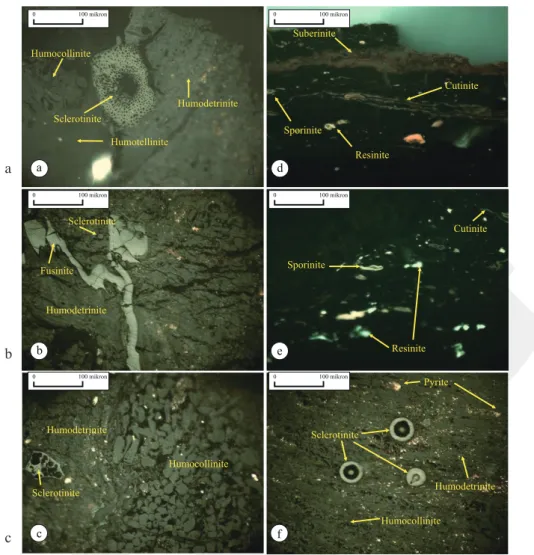
Microscopic analysis shows that huminite reflectance of the Muara Wahau coals is 0.44 % on the average, suggesting brown coal maceral nomenclature based on ICCP System 1994. The coals predominantly consist of huminite macerals, with minor liptinite and inertinite (Figure 6). Huminite maceral of the coals comprises humotelinite, humodetrinite, densinite, and humocollinite. Liptinite maceral consists of cutinite, resinite, suberinite, and sporinite. Inertinite maceral is dominated by fusinite, semifusinite, and sclerotinite.
Humotelinite (Figure 6a) is mostly found as thick layers in association with humodetrinite and cutinite, grey to dark in colour, sometimes forming lighter layers. This maceral may originate from the lignin of high plants.
Sample Number 0 m 15 14 12 10 8 6 13 11 9 77 5 4 3 Legend: GT-02, Seam-1 Dull Coal Dull Banded Coal Banded Coal 2 1 10 m 20 m 30 m
Figure 5. Coal lithotype profile of seam 1 from Drillhole GT-02.
Humodetrinite (Figure 6b) shows fragmented materials associated with inertinite, liptinite, or minerals. Densinite appears as a mixture of fine fragments of vitrinite. It is more homogenous than attrinite. Humocollinite (Figure 6c) was found as homogenous, rounded to oval bodies, and often isolated one within desmocollinite.
Cutinite (Figure 6d) is mainly present as thin continuous bands in association with vitrinite maceral. Suberinite (Figure 6d) looks as cell walls filled by other macerals, typically humocollinite. Resinite (Figure 6e) appears as rounded, oval, and unstructured material. Sporinite (Figure 6e) is present only in a minor amount. It appears as individual body with distinct cell walls and a higher relief.
Sclerotinite shows rounded to oval forms and has high reflectance (Figure 6f). This maceral is present in all coal samples.
Mineralogical analayis shows that the coal seam from the Seam 1 contains pyrite which is present mostly as fine crystals within the dense macerals (Figure 6f). The coal seam profiles
IJOG
obtain the mineralogial distribution and variation in vertical sequence.
Coal Facies/Coal Deposition
Based on the maceral quantification, the Muara Wahau coals consist of higher amount of huminite (73.4 to 88%), lower proportion of liptinite (0.6%-6.8%), and inertinite (5.8%-18%)
macerals (Table 1). The abundance of the macer
-als and miner-als along the vertical coal profile are shown in Figures 7a - d.
Figure 7a shows the variation of huminite macerals along the coal profile. Humotelinite and
attrinite amount to about 9% and 8% on the aver
-age, respectively, and exhibit no vertical varia
-tion. Humodetrinite and humocollinite average
Figure 6. Photomicrographs of macerals in the Muara Wahau coals (Seam 1). a. Sclerotinite associated with huminite; b. Sclerotinite and fusinite associated with humodetrinite; c. Humodetrinite in association with round bodies of sclerotinite and humocollinite; d. Suberinite, sporinite, resinite, and cutinite as individual bodies with distinct cell walls; e. Sporinite, resinite, and cutinite as individual bodies with distinct cell walls; f. Huminite macerals in association with round bodies of sclerotinite and pyrite mineral. a, b, c, and f in reflected light mode, while d and e in fluorescence mode.
0 100 mikron 0 100 mikron 0 100 mikron 0 100 mikron 0 100 mikron 0 100 mikron Cutinite Sporinite Humodetrinite Humocollinite Sclerotinite Sclerotinite Sclerotinite Humotellinite Humocollinite Humocollinite Sclerotinite Sporinite Cutinite Resinite Fusinite Humodetrinite Humodetrinite Humodetrinite Pyrite Resinite Suberinite a b c d e f a d b e c f
at 47% and 18%, respectively. Generally, humo
-detrinite abundance exhibits a decrease in depth, the opposite condition with that of humocollinite. In segment 1 (sample 1 - 4), the variation is low, while in segment 2 (sample 5 - 15) the variation is higher. The higher variation of humodetrinite - humocollinite in segment 2 may reflect that the groundwater in the ancient peat fluctuated more intensively.
Figure 7b indicates that the abundance of liptinite macerals generally decrease in depth.
Sporinite and cutinite only appear in some of seg
-ment 2 samples. Resinite is consistently present in all samples, averaging 1.3%. Alginite is present only in some samples of segment 2. Suberinite appears in sample 3 - 15 with varying amounts.
IJOG
Sample Number 1 2 3 4 5 6 7 8 9 10 11 12 13 14 15
Maceral group Maceral subgroup Maceral % Volume of each sample
HUMINITE 83.6 81.4 78.6 82.6 86.6 88.0 80.4 73.4 87.8 83.2 75.0 77.4 86.0 81.4 86.8 Humotelinite 12.6 11.0 10.6 10.0 10.6 12.2 8.6 5.0 12.6 10.0 2.8 6.0 8.6 7.4 7.6 Telocollinite 12.6 11.0 10.6 10.0 10.6 12.2 8.6 5.0 12.6 10.0 2.8 6.0 8.6 7.4 7.6 Humodetrinite 52.2 45.0 51.8 49.0 39.4 52.4 53.4 57.6 48.4 56.2 67.4 64.4 63.6 61.2 64.2 Attrinite 8.6 6.0 6.6 7.6 5.2 8.4 8.8 9.2 6.6 11.4 5.0 3.4 8.8 7.2 13.8 Densinite 43.6 39.0 45.2 41.4 34.2 44.0 44.6 48.4 41.8 44.8 62.4 61.0 54.8 54.0 50.4 Humocollinite 18.8 25.4 16.2 23.6 36.6 23.4 18.4 10.8 26.8 17.0 4.8 7.0 13.8 12.8 15.0 Corpogelinite 18.8 25.4 16.2 23.6 36.6 23.4 18.4 10.8 26.8 17.0 4.8 7.0 13.8 12.8 15.0 LIPTINITE 0.8 0.6 2.0 3.2 1.0 1.6 1.6 4.8 1.8 4.0 6.8 5.6 3.0 2.4 1.4 Sporinite 0.0 0.0 0.0 0.0 0.0 0.0 0.2 0.0 0.0 0.6 0.2 0.6 0.2 0.2 0.2 Cutinite 0.0 0.0 0.0 0.0 0.2 0.0 0.0 0.8 0.2 0.4 0.4 1.0 0.2 Resinite 0.8 0.6 0.6 1.2 0.8 1.0 0.6 2.4 0.6 2.4 3.4 1.4 1.4 1.6 0.4 Alginite 0.0 0.0 0.0 0.0 0.0 0.0 0.0 0.0 0.0 0.0 0.0 0.2 0.0 0.0 0.2 Suberinite 0.0 0.0 1.4 2.0 0.0 0.6 0.8 1.6 1.0 0.6 2.8 2.4 1.4 0.6 0.4 INERTINITE 8.8 12.0 15.0 7.6 6.4 5.8 13.6 18.4 6.4 9.6 11.8 13.6 8.6 12.0 9.4 Fusinite 0.4 0.2 1.2 0.8 0.4 0.0 1.2 1.2 0.4 0.6 0.4 0.6 1.4 0.6 0.0 Semifusinite 0.8 1.8 3.0 2.8 0.8 0.2 2.8 2.6 0.2 1.4 1.6 1.6 0.4 1.2 2.0 Sclerotinite 5.8 7.6 7.4 3.4 3.8 4.8 5.6 9.8 5.6 6.0 7.2 8.8 5.8 7.6 5.2 Inertodetrinite 1.8 2.4 3.4 0.6 1.4 0.8 4.0 4.8 0.2 1.6 2.4 2.6 1.0 2.6 2.2 Macrinite 0.0 0.0 0.0 0.0 0.0 0.0 0.0 0.0 0.0 0.0 0.2 0.0 0.0 0.0 0.0 MINERAL MATTER 6.8 6.0 4.4 6.6 6.0 4.6 4.4 3.4 4.0 3.2 6.4 3.4 2.4 4.2 2.4 Oxide 0.6 4.6 2.0 0.6 0.0 0.0 Pyrite 1.8 0.4 2.0 1.6 3.6 1.6 1.8 1.0 1.2 0.6 2.8 2.4 0.6 1.6 1.2 Clay 4.4 5.6 2.4 0.4 2.0 1.6 1.8 1.0 1.2 0.6 2.8 2.4 0.6 1.6 1.2 TOTAL (%) 100.0 100.0 100.0 100.0 100.0 100.0 100.0 100.0 100.0 100.0 100.0 100.0 100.0 100.0 100.0 Rv. mean (%) 0.45 0.46 0.45 0.45 0.45 0.43 0.45 0.43 0.43 0.42 0.44 0.45 0.45 0.45 0.44 Table 1. Maceral Composition of Seam 1 the Muara Wahau Coal
Resinite may originate from various plants. Thus, this maceral is not a
paleoenvironmental-indicative in the present case. Suberinite origi
-nates from cork tissues, plant components which
are similar to cuticles deriving cutinite. The su
-berinite source is easier to be destructed during coalification, consequently, suberinite is rare and
infrequently found in some coals (Taylor et al.,
1998). In the Muara Wahau coal, suberinite oc
-curs in almost entire vertical coal seam profiles, except in the lower part (sample 1 and sample 2). This may indicate that during the deposition of sample 1 - 2, trees were firstly not present in the peat. After that, the peat was starting to develop trees, forming ombrogenous peat.
In Tertiary coals, sporinite originates gen
-erally from pollen of angiospermae. Thus, the mechanism transport of pollen to the peat swamp might be dominaned by wind (Esterle and Ferm, 1994). The preservation of spore and
pollen is generally/mainly controlled by depo
-sitional environments. Taylor et al. (1998) for
example, revealed that the marine and brackish environments would be more effective for spore
and polen preservation than freshwater environ
-ments. In addition, the preservation of spore and pollen would be less efficient when exposed to atmosphere. In the Muara Wahau coal, sporinite is present only in segment 2 which might not be related to a specific environment. The absence
of sporinite in segment 1 may suggest that dur
-ing the development of the segment, there were very limited spore/pollen producing plants as the peat was still mesotrophic and dominated by aquatic plants.
Inertinite macerals of the Muara Wahau coals
mainly consist of sclerotinite maceral. In verti
-cal sequence, sclerotinite is the most abundant maceral in the top and bottom parts of the seam (Figure 7c). Sclerotinite was derived from fungi dwelling in moist environments. The presence of sclerotinite in all investigated samples suggests
that moist conditions intermittently occurred dur
IJOG
Sample No. Sample No. Sample No. Sample No. 86.8 % 81.4 % 86.0 % 77.4 % 75.0 % 83.2 % 87.8 % 73.4 % 80.4 % 88.0 % 86.6 % 82.6 % 78.6 % 81.4 % 83.6 % Maceral Gr oup Huminite (%) Maceral Gr oup Liptinite (%) Maceral Gr oup Inertinite (%) Mineral Matter (%) 15 15 15 15 1.4 % 9.4 % 2.4 % 4.2 % 2.4 % 3.4 % 6.4 % 3.2 % 4.0 % 3.4 % 4.4 % 4.6 % 6.0 % 6.6 % 4.4 % 6.0 % 6.8 % 12.0 % 8.6 % 13.6 % 11.6 % 9.6 % 6.4 % 18.4 % 13.4 % 5.8 % 6.4 % 7.6 % 15.0 % 12.0 % 8.8 % 2.4 % 3.0 % 5.6 % 6.8 % 4.0 % 1.8 % 4.8 % 1.6 % 1.6 % 1.0 % 3.2 % 2.0 % 0.6 % 0.8 % 14 14 14 14 13 13 13 13 12 12 12 12 11 11 11 11 10 10 10 10 9 9 9 9 8 8 8 8 7 7 7 7 6 6 6 6 5 5 5 5 4 4 4 4 3 3 3 3 2 2 2 2 1 1 1 1 10 1 20 = Telocollinite = Desmocollinite = Sporinite = Resinite = Fusinite = Macrinite = Sclerotinite = Inertodetinite = Semifusinite = Suberinite = Pyrite = Oxides = Clay = Densinite = Corpogelinite = Cutinite = Alginite 2 30 3 40 4 50 50 50 50 50 40 40 40 40 30 30 30 30 20 20 20 20 13 13 13 13 14 14 14 14 15 7,6 7,4 8,6 6,0 2,8 10,0 12,6 5,0 8,6 12,2 10,6 10,0 10,6 11,0 12,6 11,4 6,6 9,2 8,8 8,4 5,2 7,6 6,6 6,0 8,6 44,8 41,8 48,4 44,6 44,0 44,0 41,4 45,2 39,0 43,6 17,0 26,8 10,8 18,4 23,4 23,4 23,6 16,2 25,4 18,8 3,4 5,0 61,0 62,4 7,0 4,8 7,2 8,8 54,0 54,8 12,8 13,8 13,8 2,0 0,6 1,4 0,4 0,6 1,2 1,2 0,8 1,2 1,8 0,8 3,4 7,4 2,4 1,8 4,8 3,0 0,8 1,4 0,6 0,6 50,4 5,2 1,2 1,6 0,6 2,4 2,8 0,6 1,2 1,0 1,8 1,6 7,6 5,8 1,2 9,8 6,0 5,6 5,6 8,8 1,2 0,4 1,6 2,6 1,4 2,8 2,8 3,0 7,6 5,8 0,6 3,4 0,1 0,1 1,8 15,0 2,2 1,2 2,6 1,8 1,0 2,6 2,2 2,4 2,6 3,0 3,0 3,6 2,0 0,4 1,8 0,4 0,4 2,4 5,6 4,4 0,6 2,0 2,0 0,6 3,6 2,6 1,0 2,4 4,8 1,6 4,0 2,6 15 15 15 16 16 0,2 0,2 0,2 0,6 0,2 0,6 0,2 0,8 0,2 0,2 1,2 0,6 0,6 0,8 0,2 0,4 1,6 1,4 1,0 0,4 0,6 0,6 1,0 0,8 2,4 2,0 7,4 0,4 3,4 0,2 2,8 0,4 0,6 1,4 1,4 2,4 1,0 0,8 0,6 1,6 1,4 2,4 0,2 0,6 16 16 17 17 17 17 18 18 18 18 19 19 19 19 20 20 20 20 21 21 21 21 22 22 22 22 23 23 23 23 24 24 24 24 25 25 25 25 26 26 26 26 27 27 27 27 28 28 28 28 29 29 29 29 30 30 30 30 31 31 31 31 36 36 36 36 32 32 32 32 37 37 37 37 33 33 33 33 38 38 38 38 34 34 34 34 39 39 39 39 35 35 35 35 40 40 40 40 44 44 44 44 41 41 41 41 45 45 45 45 42 42 42 42 46 46 46 46 43 43 43 43 47 47 47 47 48 48 48 48 49 49 49 49 50 50 50 50 5 60 6 70 7 80 8 90 9 2 2 4 4 6 6 8 8 10 10 12 12 14 14 16 18 20 100 Deepness (meter) Deepness (meter) Deepness (meter) Deepness (meter)Figure 7. Comparison of maceral distribution in vertical section of the Seam-1, Muara
W
ahau coals a. huminite; b. liptinite; c. inertinite; d. minerals.
a
b
c
IJOG
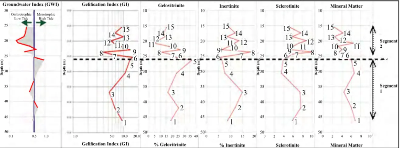
30Groundwater Index (GWI) Gelification Index (GI)
Gelification Index (GI)
Gelovitrinite % Gelovitrinite Inertinite % Inertinite Sclerotinite Sclerotinite Mineral Matter Segment 2 Segment 1 Mineral Matter 30 Ombrotrophic Low Tide MesotrophicHigh Tide
15 15 15 15 15 14 14 14 14 14 10 11 5 4 3 2 1 8 97 6 12 13 13 13 13 13 12 12 12 12 11 10 97 8 6 5 4 1110 11 10 9 9 1110 8 7 6 6 7 8 5 4 3 3 2 2 1 1 5 4 3 2 1 9 8 7 6 5 4 3 2 1 25 20 25 30 35 40 45 50 0.1 0.5 1.0 1.0 5.0 10.0 20.0 0 5 10 15 20 25 30 35 40 0 5 10 15 20 0 2 4 6 8 10 0 2 4 6 8 10
Depth (m) Depth (m) Depth (m) Depth (m) Depth (m) Depth (m)
10 10 10 10 15 15 15 15 20 20 20 20 25 25 25 25 30 30 30 30 35 35 35 35 40 40 40 40 45 45 45 45 50 50 50 50
Figure 8. Vertical variation of GWI, GI, humocollinite, inertinite, sclerotinite, and minerals.
Maceral variation and distribution in vertical section of the coal profile, as mentioned above clearly reveal that the peat developed under the mesotrophic to ombrotrophic conditions. Mesotrophic peat was mainly developed in segment 1 of the coal profile indicated by the presence of aquatic plants. On the other hand, the ombrotrophic peat might occur during the deposition of segment 2 dominated by trees with less water influence.
Figure 8 shows the vertical variation of GWI, GI, humocollinite, inertinite, sclerotinite, and mineral matter profiles. Segment 1 (sample 1 - 4) shows lower fluctuation profiles, while segment 2 (sample 5 - 15) indicates high fluctuation profiles. The change of the fluctuation pattern in the vertical coal profiles matches with that of coal lithotype.
Segmen 1 represents the development of the mesotrophic peat type. In the peat, the
hydrological regime was influenced by both groundwater and rain water. Such condition would lead to the relatively more stable water table. Segmen 2 represents the development of the ombrotrophic peat type. The hydrological regime in the ombrotrophic peat relied only on rain water. This condition would promote less stable water table, as rain water is very sensitive to season and climate changes. Water table fluctuation might occur faster resulting in a more frequent moist condition in the peat surface. This could allow fungi to grow. Thus, consequently the coal in segment 2 contains relatively more sclerotinite.
In order to investigate the relation between the above parameters, some correlation plots were made. Some of the plots are shown in Figure 9, while the complete coefficients of determination are listed in Table 2. The parameters are
16 y= 9.986x+4.589 2 R =0.371 14 12 10 8 6 4 2 0 0 0.2 Gelification Index ( G I) 0.4 0.6 0.8 1
Groundwater Index (GWI)
IJOG
Table 2. Correlation of GWI, GI, Macerals, and Minerals
No Parameter Correlation Coefficient of determination (R2)
1 GWI vs. GI + 0,37 2 GWI vs. humocollinite + 0,96 3 GWI vs. inertinite - 0,29 4 GWI vs. sclerotinite - 0,39 5 GWI vs. minerals + 0,24 6 GI vs. humocollinite + 0,49 7 GI vs. inertinite - 0,89 8 GI vs. sclerotinite - 0,62 9 GI vs. minerals + 0,02 10 Humocollinite vs. minerals + 0,13
typically positively correlated. GWI is positively correlated with GI, as both indices are sensitive to groundwater influence. Both indices are also positively correlated with mineral and some macerals which are well preserved in a wet condition under water table. Several parameters show negative correlation as shown by inertinite
and sclerotinite vs. GWI and GI. These macerals
developed under a moist condition, in parts where sometimes covered by water.
A strong negative correlation occurs in
parameters GI vs. inertinite. It is normal, as the
two parameters require opposite depositional environments. Gelification can only occur below water table (reduction) condition, while inertinite could only be derived in moist or oxidation condition. The correlation between GI and mineral matter is very weak. It is confirmed that the mineral might be epigenetic, rather than related to groundwater flow in the peat. This also confirms that the peat development was not initiated by eutrophic peat type, but it was directly commenced by mesotrophic and then ombrotrophic peats. Eutrophic peat generally depends on groundwater flow for nutrient supply. Coal which was deposited in such peatland should have well correlation with mineral matter content.
Conclusions
The thick Muara coal seam has been investi
-gated and is considered representative to indicate
variation in depositional cycles. The variation of lithotype and maceral composition reveals two segments showing different patterns along the vertical profile. Segmen 1 (lower part of the coal profile) shows depositional cycles related to relatively stable water table, as interpreted by the less frequent changes of sclerotinite, GWI, and GI. Segmen 2 (upper part of the coal profile) shows depositional cycles related to less stable water table, as it shows more frequent changes of the latter parameters. Based on the relatively low GWI, GI, and the absence of correlation between the two parameters and mineral matter content, the Muara Wahau coal is interpreted to be deposited in mesotrophic peat (segment 1) which subsequently developed to ombrotrophic peat (segmen 2).
Acknowledgment
The authors are most grateful for permission of data publication from PT. Bhakti Persada Energi. Supports from Physics Laboratory of Centre of
Geological Resources (PSDG) for petrographi
-cal analysis are gratefully acknowledged.
References
Bustin, R.M., Cameron, A.R., Grieve, D.A., and Kalkreuth, W.D., 1983. Coal Petrology - Its
IJOG
Course Notes, 3. Geological Association of
Canada, Victoria.
Calder, J.H., Gibling, M.R., and Mukhopadhay, P.K., 1991. Peat formation in a Westphalian B piedmont setting, Cumberland basin, Nova Scotia: implications for the maceral-based
interpretation of rheotrophic and raised pa
-leomires. Bulletin de la Societe Geologique
France, 162, p.283-298.
Calvert, S.J., 1999. The Cenozoic Evolution of the Larlang and Karama Basin, Sulawesi,
Proceedings of IPA 28thAnnual Convention,
p.97- 115.
Crosdale, P.J., 1995. Coal facies studies in
Australia. International Journal of Coal
Geology, 58, p.125-130.
Diessel, C.F.K., 1965. Correlation of macro- and micropetrography of some New South Wales
coals. In: Woodcock, J.T., Madigan, R.T., and
Thomas, R.G. (eds.), Proceedings-General,
8th Commonwealth Mineral and Metallurgy
Congress, 6, p.669-677.
Diessel, C.F.K., 1986. On the correlation be
-tween coal facies and depositional environ
-ment, Advances in the Study of the Sydney
Basin. Proceedings of the 20th
Symposium-The University Newcastle-Department of
Geology, Publication, 246, p.19-22.
Esterle, J.S. and Ferm, J.C.,1994. Spatial vari
-ability in modern tropical peat deposits from Sarawak, Malaysia, and Sumatra, Indonesia:
analogues for coal. International Journal of
Coal Geology, 26, p.1-41.
ICCP (International Committee for Coal Petrol
-ogy), 1998. The new vitrinite classification
(ICCP System 1994). Fuel, 77, p.349-358.
ICCP (International Committee for Coal Petrol
-ogy), 2001. The new inertinite classification
(ICCP system 1994). Fuel, 80, p.459-471.
ICCP (International Committee for Coal Petrol
-ogy), 2011. Organic petrology, macerals, microlithotypes, lithotypes, mineral, rank.
ICCP Training Course on DOM, Universi
-dade do Porto, Portugal.
Lamberson, M.N., Bustin, R.M., and Kalkreuth, W., 1991. Lithotype (maceral) composition and variationas correlated with paleo-wetland environments, Gates Formation,
northeastern British Columbia. International
Journal of Coal Geology, 18, p.87-124.
Stopes, M.C., 1919. On the four visible ingre
-dients in banded bituminous coals.
Proceed-ings of Royal Society, 90B, p.470-487.
Suárez-Ruiz, I. and Crelling, J.C. (eds.), 2008.
Applied Coal Petrology. The Role of
Petrol-ogy in Coal Utilization. Elsevier Ltd, 388pp.
Supriatna, S. and Abidin, Z.A., 1995.
Geo-logical Map of Muara Wahau Sheet, Scale
1:250.000. Geological Research and Devel
-opment Centre, Bandung.
Sykorova, I., Pickel, W., Christanis, K., Wolf,
M., Taylor, G.H., and Flores, D., 2005. Clas
-sification of huminite ICCP System 1994.
International Journal of Coal Geology, 62,
p.85-106
Taylor, G.H., Teichmuller, M., Davis, A., Dies
-sel, C.F.K., Littke, R., and Robert, P., 1998.
Organic Petrology. Gebruder Borntraeger.
Berlin . Stuttgart. 704pp.
Thomas, L., 2002. Coal Geology. John Wiley