F21 Proceeding Forum in Research, Science, and Technology (FIRST) 2016
U
NMANNED
A
ERIAL
V
EHICLES FOR
P
IONEER
F
OREST
F
IRE
M
ONITORING
Nyayu Latifah Husni
1), Ade Silvia Handayani
2), Masayu Annisah
3), DewiPermata Sari
4) 1)Electronic Department, Electrical Engineering, Politeknik Negeri Sriwijaya
E-mail: nyayu_latifah@polsri.ac.id
2)
Telecommunication Department, Electrical Engineering, Politeknik Negeri Sriwijaya
E-mail:ade_silvia_armin@yahoo.co.id
3)
Electronic Department, Electrical Engineering, Politeknik Negeri Sriwijaya
E-mail:masayu05@gmail.com
4)
Electronic Department, Electrical Engineering, Politeknik Negeri Sriwijaya
E-mail:depeesbaker@gmail.com
Abstract.This paper presents a role of UAV (Unmanned Aerial Vehicle) in monitoring the forest fire. The Usage of UAV promises better solution than remote sensingsatellite. It promises faster, cheaper, and accurate information. Moreover, due to its application below the cloud, it brings trough to be used every time.When human does self-monitoring on forest using UAV, the fire can be prevented earlier. Self-self-monitoring enables a bigger self-monitoring. The monitoring is divided into some monitored points. When human in different position and location of the same monitored area do self-monitoring, the data got can be collected and analyzed in one central monitoring. This paper shows how the UAV gets the information of the forest situation by means of visual camera and then transmitted to the android or personal computer.
Keywords: Unmanned Aerial Vehicles,Flight Controller, forest fire
I. INTRODUCTION
Human needs air for the continuing of their life. They cannot live without it although only for a few minutes. Therefore, as an important substance, it has become the obligation of human to keep the quality of the air in the right manner. There are a lot of causes that can change the quality of the air, for instance: the human daily activities [1], [2], subway station [3], [4], road traffic [5], vehicles emission[6], etc.
The changing of the air quality into a bad one or always called air pollution is one of the problems faced by most of people in the world. Some scientist made an observation about the pollution effect for the health [7], [8], [9], [10], [11]. Whereas, some researchers developed many air pollution systems that can monitor the quality of the air by making improvement in the existing methods, techniques or the sensors used. Some of the researches used artificial intelligent, i.e. fuzzy logic [12], [13], wireless sensor networks [14], [15], [16], TDLS optical gas sensing device [17], etc.
This paper focuses on forest fire monitoring. Forest fire has become a big problem in Indonesia nowadays. It happened almost every year. From the article made by greenpeace.org [18], It is known that in the peat land, the fire hotspot is five times bigger than the other land. The fire forest can occur intentionally or unintentionally. For the
intentionally one, the forest fire is usually done in order to open new land. It is very useful to clear the land quickly with a little cost. However, the condition of the dried peat land can spread the fire to other points. Therefore the fire can be bigger and wider. For the unintentionally, the peat land can be fired because of the contact of the dried peat land with the sun or the lightning splash [18].
The latest article published by detik.com [19] stated that on 17th of August 2016, USAModis satellite using Terra and Aqua sensor detected 482 hotspot forest and land fire in Indonesia. August till October become the peak of dry season. They become the critical period of forest and land fire. Not only in Indonesia, in 15th of August 2016, forest fire also happened in California [20]. The fire destroyed thousand of civil houses and forced them to move to the safe place. Moreover, the forest fire can cause some other difficulties. The destruction of the forest occurs quickly. Among of them are: many animals lose their places, some injuries will occur, a lot of diseases threaten, and some of the death intimidate.
fire. Therefore, a system that can predict the location of the fire is really useful.
In this research, a forest fire monitoring using Unmanned Aerial Vehicle (UAV) is offered. Using UAV, an operator can monitor the condition of the fire from the other place far from the exact location. By having the information collected by the UAV, human can make a correct strategy so that the loss can be minimized. UAV provides the position of the forest fire, the latitude and also the longitude of the location using the GPS supplied on them. The situation of the fire can also be seen from the camera inserted in the UAV. Moreover, when there is no information about the fire, the UAV can be used to detect the existing smoke or heat of fire by employing the sensors implemented to UAV. Unfortunately, in this research, such sensors have not been installed yet, so the UAV can only monitor the location and situation of the fire using the GPS and camera. That's why the tittle of this paper used the word 'pioneer'. This research is the first step of the complete and complicated future forest fire monitoring.
Fig 1. Effect of forest fire in California [20]
The contribution of this paper is to give an alternative solution in controlling the forest fire. This paper intends to enlarge the consciousness of the reader that the forest fire can be prevented by self-monitoring using UAV. It is hoped that early detection of forest fire can be achieved. Early detection will lead to early rescue and it means that any losses that may be occurred can be decreased. This instrument promises faster, cheaper, and accurate information than remote sensingsatellite[21]. By self-monitoring, the forest and land condition and situation can be updated every time. The fact that it works below the cloud allows it to be used to monitor the forest every time even in the rainy seasons. By deploying some UAVs into some points of monitoring, the preservation of forest can be kept.
II. UNMANNEDAERIALVEHICLES
Unmanned aerial vehicle (UAV) is an aircraft without a human pilot aboard. It can be operated autonomously by onboard computers or by human using remote control. There are many kinds of UAV. It can be classified based on its mode of flight, its characteristic of the task and design[22], and also its flight endurance and payload. According to the mode of flight, UAV can be divided into fixed wing
unmanned aircraft, Rotor UAV, unmanned airship etc. And according to the characteristics of the design and task classification, UAVs generally include persistent type without one aircraft, tactical UAV, a miniature unmanned aircraft, pocket UAVs and so on. According to its flight endurance and payload [23], UAV can be divided into:
• High Altitude Long Endurance (HALE) UAVs, as for
example the Northrop Grumman Ryan’s Global Hawks (65000 ft altitude, 35 hours flight and 1900 lbs. payload).
• Medium Altitude Long Endurance (MALE) UAVs, as for
example the General Atomics’ Preda- tor (see Figure 2.15, left, with 27000 ft altitude, 30/40 hours flight and 450 lbs payload)
• Tactical UAVs such as the Pioneer with 15000 ft altitude, 5-6 hours flight and 25 Kg. payload
The miniature unmanned aircraft vehicle has some advantages, namely: low cost, small volume, light weight, flexible, landing with relative few restrictions, and can adapt to the complicated and changeable environment advantage[22]. Therefore, there are a lot of researchers who are interesting in it. Moreover, due to the high flexibility and strong adaptability, the miniature unmanned aircraft in the military and civilian have a wide application prospect. It also becomes the reason of using the miniature unmanned aircraft as the UAV forest fire detection[22].
UAV is also widely used for many application, for instances: electronic jamming task in military, target indication and biochemical weapons detection, the communication relay, environmental studies, natural disasters monitor and support, border patrol, agricultural survey, and large-scale ranch and forest fire detection[22].The unmanned vehicle’s advantage is
particularly prominent when it fights in the city. It can fly in slow speed, in order to avoid hitting buildings; it can fly to large buildings on hold for urban reconnaissance mission in the civil context[22].
Table 1. Recent Researches of UAVs application on forest monitoring
Authors Research Scopes References
Lan Zhang tries software application on UAV for forest monitoring
[22]
Jian Zhang evaluates the value of drone applications in long-term ecological studies
[26]
Rakan A.Zahawi
assesses whether remote sensing measurements from lightweight unmanned aerial vehicles (UAV) are a cost-effective substitute for tradi-tional field measures
[27]
Max Messinger
comparesSFM- and airborne Light Detection and Ranging (LiDAR).
[28]
Chi Yuan makes a survey on technologies for automatic forest fire monitoring
[24]
Hendry Cruz uses a novel method for detecting forest fires, through the use of a new
Proceeding Forum in Research, Science, and
color index, called the Forest Fi Detection Index (FFDI)
Khaled A. Ghamry
investigates forest monitoring an fire detection strategies using a tea of unmanned aerial vehicles (UAV and unmanned ground vehicl (UGVs)
UAV with computer vision based on systems provides rapid, mobile, and low-cos monitoring, detecting, and even fighting f integration of UAV with remote sensing te for the execution of long-term, monotonou tasks beyond human capabilities[24]. It critical spatial, spectral, and temp requirements, offering the potential to serv supplement to existing methods[24]
The Global Positioning System (GPS) was developed by the Department of Defense (DoD) primarily for the U.S. military to provide precise estimates of position, velocity, and time[25]. GPS is not the first satellite navigation system. The first operational system was fielded by the U.S. Navy in 1964, and was named the Navy Navigation Satellite System [25].GPS consists of three segments: the space segment; the control segment; and the user segment. The space segment comprises the satellites and the control segment deals with the management of their operations. The user segment covers activities related to the development of GPS user equipment and services[25].
Table 1 describes some recent researches of UAVs' application that are used for forest fire monitoring. It shows that the use of UAVs are still interesting to develop.
III. DEVELOPMENT, TESTING ANDMEA
The block diagram of the UAV in this
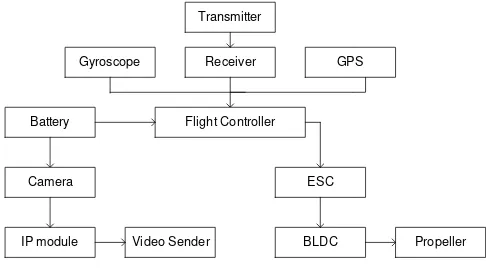
Fig. 2. Block diagram of UAV
The roles of each components in t diagramin Fig.2 can be explained as follow: 1. The battery of the UAV is used for th
battery used is LIPO 3 cells 220 mAh battery used is power swithching that gi the FC, GPS, and also the receiver.
and Technology (FIRST) 2016 nous, and repeated It also meets the poral resolution erve as a powerful The Global Positioning System (GPS) was developed by the Department of Defense (DoD) primarily for the U.S. military to provide precise estimates of position, velocity, and time[25]. GPS is not the first satellite navigation system. The first operational system was fielded by the U.S. Navy in 1964, and was named the Navy Navigation Satellite System [25].GPS consists of three segments: the space segment; the control segment; and the user segment. The space segment comprises the satellites and the control segment deals with the management of their operations. The user segment covers activities related to the development of GPS user equipment and services
Table 1 describes some recent researches of UAVs' application that are used for forest fire monitoring. It shows that the use of UAVs are still interesting to develop.
EASUREMENT t gives the power to
2. Radio Transmitter and R this research is also used remote Transmitter has fu that sends signal 2.4 GHz 3. Flight Controller (FC) is th
Signal received by the rec In addition, the data from accelerometer is also pro achieve the balancing of th 4. Electronic Speed Controlle
driver motor of Brushle PWM signal received from the ESC to the BLDC. 5. Brushless DC Motor(BLD
the propeller so that the UA 6. Camera is used to take
camera transmitter to tran receiver.
7. Global Positioning System position controller of UAV. 8. Propellers used is propelle
propellers, Clock Wise (C (CCW). CW and CCW p puller respectively. Be ca UAV.
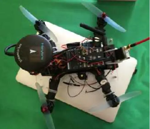
The frame of the UAV and th in the UAV frame can be see physical shape of the UAV use Fig. 5, while the flowchart of th
Fig. 3. QAV 250 frame [31].
F23
Khaled A. Ghamry
The Global Positioning System (GPS) was developed by the Department of Defense (DoD) primarily for the U.S. military to provide precise estimates of position, velocity, and time[25]. GPS is not the first satellite navigation system. The first operational system was fielded by the U.S. Navy in 1964, and was named the Navy Navigation Satellite System [25].GPS consists of three segments: the space segment; the control segment; and the user segment. The space segment comprises the satellites and the control segment deals with the management of their operations. The user segment covers activities related to the development of GPS user equipment and services
Table 1 describes some recent researches of UAVs' application that are used for forest fire monitoring. It shows that the use of UAVs are still interesting to develop.
Radio Receiver. The UAV in sed the remote controller. The function as the remote control GHz to the receiver .
is the main controller of the UAV. receiver will be processed in FC.
m other sensor, such as gyro and rocessed in this FC in order to f the UAV.
troller (ESC) has function as the hless DC Motor(BLDC). The rom the FC will be transferred by LDC) is the actuator to actuate
eller 5x3 Inch. There are 2 kind (CW) and Counter Clock Wise propeller is used as pusher and careful when install these to the
d the position of each component seen in Fig. 3 and Fig. 4. The used in this research is showed in f the UAV can be seen in Fig. 6
Fig. 4. The position of components in UAV The body of the UAV uses the fram Lumenier [31]. The QAV250 is a symme airframe that accommodates 5" props. measured motor shaft to motor shaft diago QAV 250 was chosen in this research becau size, its performance is also great, and it is Moreover, it can be upgraded and it is equip accessories and add ons, so that it becom customizable. Fig. 5. shows the QAV 250 f
The remote transmitter sends signals tha the receiver placed on board of the UAV. connected to the flight controller. The GP the information to the flight controller abou or the information of the target location a addition, the FC is also inputted the s gyroscope. The flight controller then proce and gives signal to the BLDC motor to mo position. The ESC (Electronic Speed function to send signal to the BLDC. This chosen properly, it should be compatible with also the battery.
V
rame produced by metric 250mm size . The 250mm is gonally [31]. The cause it has a small it is low cost frame. quipped with many omes flexible and 0 frame.
that are captured by V. The receiver is GPS will also give bout the coordinate n and position. In signal from the cesses the data got move to the target d Controller) has his ESC should be with the motors and
Fig. 5. Physical shape of UAV .
Sta
Finish Gyroscope gives
the balancing data
RC Transmitter sends signal to the receiver
Flight Controller proce RC Receiver, Gyro
ESC gets the PWM
BLDC actuates
RC Receiver receives the signal
Fig. 6. Flowchart of the UAV The display of UAV mon android. The user only need tower planner to its mobile ph UAV taken from the android. different height, 20 - 50 m from
Some photograps of forest in this research can be seen in in different height and view.
Besides using android, th displayed on PC using missio application should be installed seen in Fig. 9.
AV
tart
inish
GPS provides the position data
IP Camera Captures the environment photos
Video Sender sends the photos
PC/Smart Phone receives the photos
cesses the data from yroscope and GPS
M signal from FC
es the propeller
V
onitoring can be seen from the eds to install the application of phone. Fig. 7 is the data of the id. The photos are taken from rom the surface of the sea. est monitoring taken from UAV in Fig. 8. The photos were taken .
Proceeding Forum in Research, Science, and
Fig. 8.thephotograph of the UAV from diff 20 m, (b) 30 m, (c) 40 m, and (d) 50 m.
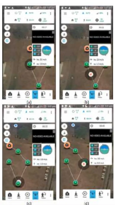
The path of the UAV can be monitored u 9 shows the path of the UAV that it should can be arranged using the mission planner ap the path is set, the UAV will follow the setti Fig. 9 shows the setting path and the respectively. The measurements of the path two modes, manual and auto pilot mode. F UAV in manual mode take off.
From the measurement, there were some It can be seen from the yellow line and the p 9. Yellow line is the settingpath, while the way path of the UAV. This error happen possible reasons. First, it is due to the bad w calibration of the UAV setting. Therefore, the setting to this UAV, that conditions attention.
and Technology (FIRST) 2016
different height. (a)
d using the PC. Fig. uld take. The path r application. Once setting way-points. e UAV way path ath can be done in . Fig. 9 shows the me errors occurred. e purple line in Fig. he purple one is the pened due to some d weather or missed re, before applying ns should be paid
Fig. 8. (a, b, c, and d) forest fir different side, height, and view
Fig. 9. UAV way path in manu
IV. PROPO
For the future development, th with the gas and heat sen concentration of the air and the It is hoped using these sensors can be detected more quickly s successful. In addition, next re deployments in some points. to a sensor network. When forest area, a central monitorin and easy monitoring can be do
V. CON
From this research, it can provides a great promise in forest fire monitoring. It ca android easily. It is hoped developed to be a perfect UA monitoring in the future.
F25
t fire monitoring using UAV from iew.
anual take off mode
OSEDWORK
t, the UAV will be accomplished ensors in order to know the the predicted location of the fire. ors, the fire spot in specific area y so that monitoring can be more t research will focus on the UAV ts. Each point will be connected n it deploys to some points in itoring can be built. Thus, a real
done.
NCLUSION
ACKNOWLEDGMENT
Authors thank to Higher Education General Director (DIKTI), the Ministry of National Education Department Indonesia and State Polytechnic of Sriwijaya under Research Collaboration for their financial supports in Competitive Grants Project. Our earnest gratitude also goes to all researchers in Signal Processing and Control Laboratory, Electrical Engineering, State Polytechnic of Sriwijaya who provided companionship and sharing of their knowledge. We also thank to Syahidal Wahid, Dwi Ramzy and Darussalam for their cooperation in setting and developing the UAV.
REFERENCES
[1] E. Sfax, “A prediction distribution of atmospheric pollutants using
support vector machines , discriminant analysis and mapping tools ( Case study : Tunisia ),” vol. 2, no. 1, pp. 11–23, 2016. [2] Z. Chowdhury, L. Campanella, C. Gray, A. Al, J. Marter-kenyon,
D. Pennise, D. Charron, and X. Zuzhang, “Measurement and
modeling of indoor air pollution in rural households with multiple stove interventions in Yunnan, China,”Atmos. Environ., vol. 67, pp. 161–169, 2013.
[3] H. Liu, M. Kim, O. Kang, B. Sankararao, J. Kim, J. C. Kim, and
C. K. Yoo, “Sensor Validation for Monitoring Indoor Air Quality in a Subway Station,”Indoor Built Environ., vol. 21, no. 1, pp. 205–221, 2012.
[4] Y. Kim, M. Kim, J. Lim, J. T. Kim, and C. Yoo, “Predictive
monitoring and diagnosis of periodic air pollution in a subway
station,”J. Hazard. Mater., vol. 183, no. 1–3, pp. 448–459, 2010. [5] N. Castell, M. Kobernus, H. Y. Liu, P. Schneider, W. Lahoz, A. J.
Berre, and J. Noll, “Mobile technologies and services for
environmental monitoring: The Citi-Sense-MOB approach,”
Urban Clim., vol. 14, pp. 370–382, 2015.
[6] K. Z. and S. Batterman, “Air Pollution and Health Risks due toVvehicle Traffic,”no. 2, pp. 307–316, 2014.
[7] K.-H. Kim, E. Kabir, and S. Kabir, “A review on the human health impact of airborne particulate matter,”Environ. Int., vol. 74, pp. 136–143, 2015.
[8] B. Brunekreef and S. T. Holgate, “Air pollution and health,”
Lancet, vol. 360, no. 9341, pp. 1233–1242, 2002.
[9] N. Künzli, R. Kaier, S. Medina, M. Studnicka, O. Chanel, P. Filliger, M. Herry, F. H. Jr, V. Puybonnieux-Texier, P. Quénel, J.
Schneider, R. Seethaler, J. C. Vergnaud, and H. Sommer, “Public
health impact of outdoor and traffic related air pollution: a
European assessment,”Lancet, vol. 356, pp. 795–801, 2000. [10] P. N. Ruparel, N. J. Mistry, and N. D. Jariwala, “Health impacts
of urban road traffic noise,”Iciet’2013, pp. 259–261, 2013.
[11] B. Barnes, A. Mathee, E. Thomas, and N. Bruce, “Household
energy, indoor air pollution and child respiratory health in South
Africa,”J. Energy South. Africa, vol. 20, no. 1, pp. 4–13, 2009. [12] M. Abdel and K. Jaradat, “FUZZY LOGIC CONTROLLER
DEPLOYED FOR INDOOR AIR QUALITY CONTROL IN
NATURALLY VENTILATED ENVIRONMENTS,” vol. 60, no.
1, pp. 12–17, 2009.
[13] M. N. Assimakopoulos, A. Dounis, A. Spanou, and M.
Santamouris, “Indoor air quality in a metropolitan area metro using fuzzy logic assessment system,”Sci. Total Environ., vol. 449, pp. 461–469, 2013.
[14] S. Abraham and X. Li, “A cost-effective wireless sensor network
system for indoor air quality monitoring applications,”Procedia Comput. Sci., vol. 34, pp. 165–171, 2014.
[15] S. C. Hu, Y. C. Wang, C. Y. Huang, and Y. C. Tseng, “Measuring air quality in city areas by vehicular wireless sensor networks,”J. Syst. Softw., vol. 84, no. 11, pp. 2005–2012, 2011.
[16] K. K. Khedo, R. Perseedoss, A. Mungur, U. O. Mauritius, and
Mauritius, “A Wireless Sensor Network Air Pollution Monitoring System,”Science (80-. )., vol. 2, no. 2, p. 15, 2010.
[17] S. Ag and C. Technology, “Miniaturized TDLS optical gas
sensing device for air quality monitoring Alexandru Popescu,” no.
February 2010, p. 2013.
[18] http://www.greenpeace.org/seasia/id/press/reports/Sumatera-Akan-Tertutup-Dengan-Asap/, “Sumatera : Akan Tertutup
Dengan Asap,” 2014.
[19] Detik.com, “(http://news.detik.com/berit a/3277135/satelit-modis-deteksi-482-hotspot-kebakaran-hutan-dan-lahan-di-indonesia).”
2016.
[20] News.detik.com,
“Http://news.detik.com/internasional/3276074/kebakaran -hutan-di-california-meluas-4-ribu-warga-mengungsi.” 2016.
[21] Cifor.org, “http://blog.c ifor.org/26689/drone-murah-dapat-
merevolusi-pemantauan-hutan-walau-menghadapi-guncangan?fnl=id.” 2015.
[22] L. Zhang, B. Wang, W. Peng, C. Li, Z. Lu, and Y. Guo, “A Method for Forest Fire Detection Using UAV,” vol. 81, no. Cst,
pp. 69–74, 2015.
[23] D. Ingeniero and D. E. T. On, “Cooperative Perception
Techniques for Multiple Unmanned Aerial Vehicles :
Applications to the Cooperative Detection , Localization and
Monitoring of Forest Fires,” 2007.
[24] C. Yuan, Y. Zhang, and Z. Liu, “A survey on technologiesfor automatic forest fire monitoring , detection , and fighting using
unmanned aerial vehicles and remote sensing techniques,” vol.
792, no. August 2014, pp. 783–792, 2015.
[25] P. Enge, “PROCEEDINGS OF THE IEEE, VOL. 87, NO. 1, JANUARY 1999.” 1999.
[26] J. Zhang, J. Hu, J. Lian, Z. Fan, X. Ouyang, and W. Ye, “Seeing
the forest from drones : Testing the potential of lightweight drones
as a tool for long-term forest monitoring,”BIOC, vol. 198, pp. 60–69, 2016.
[27] R. A. Zahawi, “Using lightweight unmannedaerial vehicles to
monitor tropical forest recovery,”Biol. Conserv. 186 287–295,
2015.
[28] M. Messinger, G. P. Asner, and M. Silman, “Rapid Assessments
of Amazon Forest Structure and Biomass Using Small Unmanned
Aerial Systems,” pp. 1–15, 2016.
[29] H.Cruz, M. Eckert, J. Meneses, and J. Martínez, “Efficient Forest
Fire Detection Index for Application in Unmanned Aerial
Systems ( UASs ),” 2016.
[30] K. A. Ghamry, M. A. Kamel, and Y. Zhang, “Cooperative Forest
Monitoring and Fire Detection Using a Team of UAVs-UGVs,”
pp. 1206–1211, 2016.
![Fig 1. Effect of forest fire in California [20]](https://thumb-ap.123doks.com/thumbv2/123dok/1462595.2032318/2.595.311.553.539.757/fig-effect-forest-california.webp)