©2014 Pusat Penelitian Geoteknologi
GEOCHEMICAL EVIDENCE OF ISLAND-ARC ORIGIN IN
VOLCANIC ROCKS OF CENTRAL SUMATERA
Bukti Geokimia Asal Mula Busur Kepulauan dalam Batuan
Volkanik di Sumatera Tengah
Iskandar Zulkarnain
11
Kedeputian Bidang IPK LIPI
ABSTRACT Geochemical study on volcanic in Lampung and Bengkulu regions proposed a preposition that the western part of Sumatera is formed by a separated fragment with island-arc character and does not belong to continental margin of Eurasia. Geochemical signatures of western and eastern volcanic in Central Sumatera have confirmed the preposition indicated by evidences of existing island-arc tectonic environment on the western volcanic and both island-arc and continental tectonic environments on the eastern volcanic. Besides that, the geochemical data in this region have revealed the third tectonic environment reflecting development of back-arc tectonic setting in the geological history of the island. The island-arc tectonic setting is marked by higher ratio of (Ti/Ce)N, varying from 0.15 to 0.3, but in narrow ratio of (Ta/Nb)N, between 1.0 to 1.5, while the Active Continental Margin tectonic environment is characterized by wide range of (Ta/Nb)N ratio, ranging from 1.2 to 2.8 but with ratio of (Ti/Ce)N less than 0.1. The back-arc basin tectonic setting is marked by high ratio of (Ti/Ce)N, up to more
than 0.8. The results are made based on rock
chemistry analysis including major, trace and rare earth elements.
Keywords: geochemical, volcanic, Sumatera, island-arc, continental, preposition, back-arc basin.
ABSTRAK. Studi geokimia batuan gunungapi di
wilayah Lampung dan Bengkulu telah menghasilkan sebuah preposisi yang menyatakan bahwa bagian barat pulau Sumatera dibentuk oleh sebuah fragmen yang terpisah dengan ciri busur kepulauan dan ia tidak termasuk tepian benua Eurasia. Pola geokimia batuan gunungapi di sisi barat dan timur Sumatera Tengah, telah mengkonfirmasi preposisi tersebut yang ditunjukkan oleh bukti-bukti tentang keberadaan lingkungan tektonik busur kepulauan pada batuan gunungapi di sisi barat dan kedua lingkungan tektonik busur kepulauan dan benua pada batuan gunungapi di sisi timur. Di samping itu, data geokimia wilayah ini telah mengungkap lingkungan tektonik ketiga yang mencerminkan perkembangan lingkungan tektonik busur belakang dalam sejarah geologi pulau ini. Lingkungan tektonik busur kepulauan ditandai oleh rasio (Ti/Ce)N yang tinggi, berkisar antara 0.15-0.3, tetapi dalam rasio (Ta/Nb)N yang sempit antara 1.0 dan 1.5. Sementara itu, lingkungan tektonik tepian benua aktif dicirikan oleh rasio (Ta/Nb)N yang lebar, berkisar dari 1.2 s/d 2.8, tetapi dengan rasio (Ti/Ce)N kurang dari 01. Lingkungan tektonik busur belakang ditandai oleh rasio (Ti/Ce)N yang tinggi, hingga lebih dari 0.8. Semua hasil tersebut di atas didasarkan pada analisis kimia batuan yang mencakup unsur utama, jejak dan unsur jarang.
Kata kunci: geokimia, volkanik, Sumatera, busur kepulauan, benua, preposisi, cekungan busur belakang Jalan Jenderal Gatot Subroto 10 Jakarta 12710
Telp. (021) 52251804 Fax. (021) 5225 1804 Email : [email protected]
INTRODUCTION
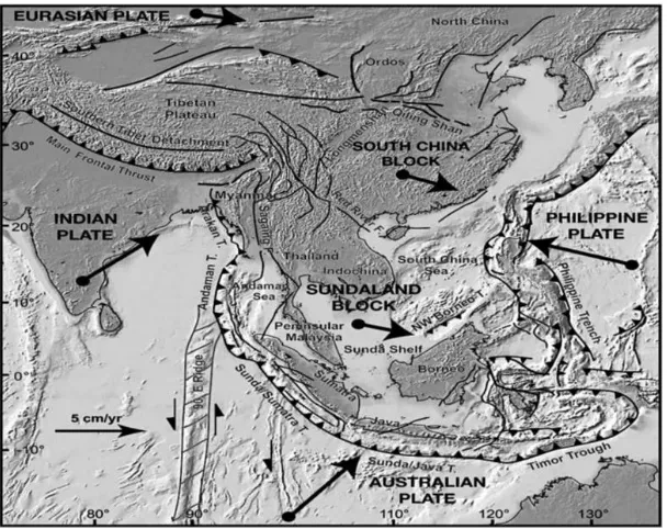
Sumatera is situated in the westernmost of Indonesia region and one of developing islands among five main islands in the archipelago country. Geologically, the island is composed by different rocks, dominated by volcanic and sedimentary rocks, with different age, from Paleozoic Era to Quaternary Period. Regionally, Sumatera together with Java, Kalimantan, Sulawesi, Malaya Peninsula, Indochina, Thailand and shallow water among them (Sunda Shelf), have formed the Sundaland Block (Figure 1). This Block is believed as the Eurasia continental margin in the southeast, where the Indian Australian oceanic crust subducted oblique beneath the Sumatera (Fitch TJ., 1972; Hamilton W., 1974, 1979). Therefore, many authors classify Sumatera as continental margin of Eurasia or in other words, the island belongs to active continental margin tectonic setting (Hamilton, 1979; Curray, 1989; Barber, 2000; Barber and Crow, 2003; Crow, 2005).
From the geological history point of view,
Sumatera has cropped out different rocks with various ages, from Paleozoic era to Quaternary period. The geochronological rock data lead to an understanding that the island consists of several
parts of micro continents, namely Sikuleh Continental Fragment, Natal Continental Fragment, and three micro continents, such as Mergui Micro Continent, Malaka Micro Continent and East Malaya Micro Continent (Cameron et al., 1980; Pulunggono and Cameron, 1984). Along the western side, between the Sikuleh and Natal continental fragments with the Mergui Micro Continent, the Woyla Terrains (Mesozoic in age) extent from NW to SE (Figure 2). Meanwhile, the same region is recognized also to be formed by two different micro continents, known as Sibumasu and Indochina micro continents (Metcalfe, 1998).
Two above point of views confirmed that Sumatera has been formed by the continental components and belongs to active continental margin tectonic setting.
Different from the above opinions, a recent geochemical study, based on trace elements and REEs, that has been conducted on volcanic rocks along the western side of the Sumatera Island, particularly in Lampung and Bengkulu has
revealed different evidences indicating the presence of strongly island-arc character in the western side of the island. It has changed gradually into continental character eastwards Figure 1. Sumatera as part of Sundaland Block where Australian Plate subducted
©2014 Pusat Penelitian Geoteknologi
and become fully continental from Sumatera Fault Zone areas to the east side of the island. The phenomenon has been recognized clearly in Lampung and Bengkulu regions. These evidences lead to a preposition that the western side component of the Sumatera consisting of Sikuleh and Natal continental fragments and Woyla
Terrains should be developed in island-arc tectonic setting before it moved and collided to the continental margin of Eurasia. It means that all volcanic produced by interaction between the Indian oceanic crust and the western component of the Sumatera has to be island-arc in character.
Figure 2. Tectonic map of the Sumatera and surrounding area showing micro continent components as the main components of the Sundaland Block (after
Pulunggono & Cameron, 1984 and Metcalfe, 1998)
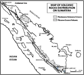
As anywhere in the world, the subduction system has controlled the formation of volcanic activities as well as the volcanic chains in the western coast of the Sumatera. The volcanic age ranges from Pliocene to Holocene and the younger ones has been distributed widely along the western side of the island (Figure 3).
As mentioned above, the volcanic generated by subducting of Indian oceanic crust beneath the western component of Sumatera has to be island-arc character, so that the geochemical signatures of all volcanic along the western side of the island can be used to confirm whether the western component of the island is island-arc fragment or not. The confirmation for the above preposition is already obtained from the volcanic in Lampung (Zulkarnain, 2011) and in Bengkulu (Zulkarnain, 2012).
So, the aim of this paper is to demonstrate the geochemical signatures of volcanic in Central Sumatera in order to confirm the continuation of the island-arc character of the volcanic along the western side of Sumatera in proofing the above preposition.
SAMPLE LOCATIONS AND ANALYTICAL METHOD
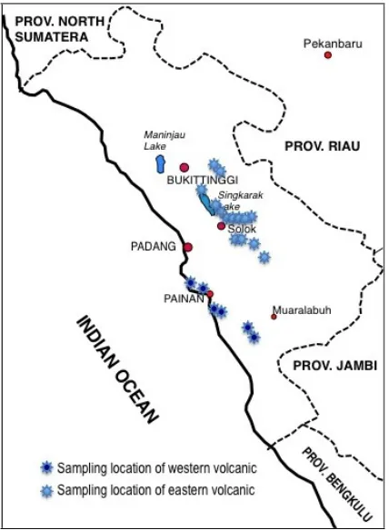
Volcanic samples were collected in Painan and Muara Labuh areas representing the western volcanic and in Solok area which belongs to eastern volcanic. Due to lack of fresh rock samples from the western side, only six samples were chemically analyzed, while from the eastern volcanic there are 18 samples were analyzed. All samples were analyzed for major-, trace- and rare earth elements (REE). The analysis was done by Activation Laboratories in Canada under analysis code 4Litho. They offered a lithium metaborate/ tetraborate fusion ICP Whole Rock Package and a trace element ICP/MS package that is unique for scope of elements and detection limits. The two packages are combined in Code 4Litho and Code 4Lithoresearch.
The western side volcanic were sampled near to the coast, therefore it should represent the island-arc character, while the eastern side ones have been collected around the Sumatera Fault Zone which is expected to reflect gradually change into continental character (Figure 4).
Figure 4. Sample locations map showing the location where samples of the western and eastern volcanic in Central
©2014 Pusat Penelitian Geoteknologi ANALYTICAL RESULTS
The analytical results will be discussed separately from major elements through trace elements to REE. The samples of the western volcanic are labeled with PN (for Painan) and ML (for Muara Labuh), while the samples of eastern volcanic are labeled with SL (for Solok).
Major Elements
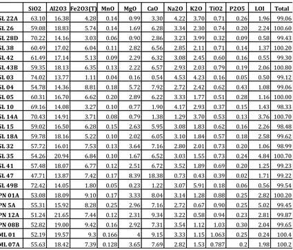
The analytical results of the major elements are given in the Table 1. Eighteen samples of the eastern volcanic show wide range of SiO2 content, varying from 47.71 weight % to around 74.4 weight %. Compositionally, they range from andesitic basalt to granite or rhyolite, but most of them are andesite or dacite. The wide range of rocks composition and domination of more acidic rocks are character of the continental setting volcanic, generating in the subduction zone
where oceanic crust subducted beneath continental margin. It indicates that the eastern volcanic should be derived from magma generated in the continental setting. Meanwhile, the four samples of western volcanic are very similar in composition with SiO2 content around 51 to 55 weight %. This pattern is common in the volcanic derived from magma in the subduction system where oceanic crust subducted beneath another oceanic crust (island-arc type). Volcanic derived from magmas in the subduction system can be classified as continental and island-arc types depend on the type of the crust beneath which the oceanic crust subducted. Therefore, it is necessary to identify more detail in order to find out the character of the western volcanic.
Statistically, it is clear in the above table that among the eastern volcanic samples, there is one unusual sample containing extreme high CaO
Table 1. Analytical results of the Major Elements of western and eastern volcanic from Central Sumatera (Painan and Solok regions)(in weight %).
SiO2 Al2O3 Fe2O3(T) MnO MgO CaO Na2O K2O TiO2 P2O5 LOI Total SL 22A 63.10 16.38 4.28 0.14 0.99 3.30 4.22 3.70 0.71 0.26 1.96 99.06
SL 26 59.08 18.83 5.74 0.14 1.69 6.28 3.34 2.30 0.74 0.20 2.24 100.60
SL 28D 70.22 14.16 3.03 0.06 0.90 2.86 3.23 3.99 0.32 0.09 0.58 99.43
SL 38 60.49 17.02 6.04 0.11 2.82 6.56 2.85 2.11 0.71 0.14 1.37 100.20
SL 42 61.49 17.14 5.13 0.09 2.29 6.32 3.08 2.45 0.60 0.16 0.55 99.30
SL 43B 59.35 18.13 6.35 0.13 2.22 6.57 2.93 2.03 0.79 0.19 2.06 100.80
SL 03 74.02 13.77 1.11 0.04 0.16 0.54 4.53 4.23 0.16 0.05 0.50 99.12
SL 04 54.78 14.36 8.81 0.18 5.72 7.92 2.72 2.42 0.62 0.43 1.08 99.06
SL 05 60.31 16.70 6.62 0.20 2.89 6.22 3.33 1.77 0.51 0.28 1.16 100.00
SL 10 69.16 14.08 3.27 0.10 0.77 1.90 4.17 2.93 0.37 0.15 1.43 98.33
SL 14A 70.43 14.91 3.71 0.08 0.79 1.38 1.29 3.70 0.53 0.13 3.76 100.70
SL 15 59.02 16.50 6.28 0.15 2.63 5.95 3.08 1.83 0.62 0.16 2.26 98.48
SL 18A 59.78 18.16 5.22 0.10 2.02 6.05 3.10 1.84 0.57 0.18 2.58 99.62
SL 32 57.72 16.01 7.53 0.13 3.64 7.16 2.80 2.01 0.73 0.20 1.06 98.99
SL 35 54.26 20.94 6.84 0.10 1.67 6.52 3.03 1.55 0.73 0.24 4.84 100.70
SL 41 57.48 18.07 6.77 0.12 2.51 6.72 3.52 1.89 0.69 0.20 1.25 99.23
SL 47 47.71 13.87 7.42 0.17 8.39 18.38 0.73 0.43 0.39 0.02 1.71 99.22
SL 49B 72.42 14.05 1.80 0.05 0.23 1.22 3.07 5.91 0.18 0.06 0.56 99.54
PN 01A 53.08 18.09 9.10 0.17 3.33 8.04 3.14 1.28 0.88 0.25 2.82 100.20
PN 5A 55.31 15.92 8.28 0.25 2.96 7.16 2.72 0.67 0.90 0.25 5.02 99.45
PN 12A 51.24 21.65 7.44 0.12 2.31 9.34 3.22 0.58 0.94 0.23 2.81 99.87
PN 08B 52.82 19.00 9.42 0.16 2.92 7.31 3.54 1.12 1.03 0.30 2.04 99.65
ML 01 52.19 19.57 9.3 0.166 4 9.15 3.33 1.15 1.063 0.25 0.24 100.4
content, up to 18 weight % and high MgO content, up to 8.39 weight % (sample SL 47). This sample contains low Al2O3, about 13 weight % and extreme low Na2O, less than 1 weight % and K2O, less than 0.5 weight %. This sample should not be derived from magmas either in the continental environment or in the island-arc setting. It must be crystallized from magmas generated in different tectonic setting.
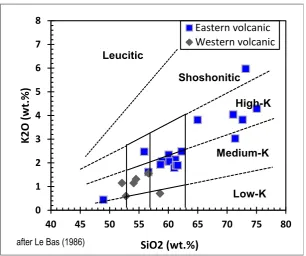
Plot the samples in the correlation diagram of SiO2 versus K2O (Le Bass et al., 1986) shows clearly that all volcanic are classified as medium-K to high-medium-K types, while one sample is identified as shoshonitic rock (Figure 5). It is also clear that most of the eastern volcanic are andesite (SiO2 ranging from 53 to 57 weight %) and dacitic (SiO2 varying from 57 to 63 weight %) to rhyolite (SiO2 more than 63 weight %), while one sample is categorized as basalt. The shoshonitic rock looks like originally to be derived from crystallized magma, because it does not show indication of metasomatism process (very low LoI and high potassium and sodium). The basalt sample (most basic one with SiO2 around 48 weights %) is the unusual sample and it is plotted
separately far away in the diagram from the others. In other side, the samples of western volcanic are distributed randomly where four samples are classified as andesite medium-K, while the other two samples are distributed along the border between Low-K and Medium-K.
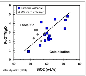
As volcanic expected to be derived from the island-arc environment, the six samples of western volcanic should belong to the Low-K type, but four of them show enrichment on potassium. It is probably related to its original magma composition containing higher potassium. However, plot of all samples in the affinity diagram of SiO2 versus FeO*/MgO (Miyashiro, 1974) confirm that almost all samples of western volcanic classify as tholeiitic rocks (only one sample lying at the border), together with a few samples of eastern volcanic, while most of the samples from eastern side belongs to calc-alkaline affinity (Figure 6). The unusual sample, although it shows basic composition, is plotted as calc-alkaline rocks and it means the sample
©2014 Pusat Penelitian Geoteknologi changing of chemical and mineralogical compositions of the rocks. In other side, trace elements and REE are more stable and not so easy to be influenced by the surrounding processes, chemically or physically, particularly the compatible elements.
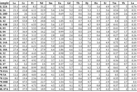
All 22 samples of western and eastern volcanic in Central Sumatera were analyzed for selected trace elements and the results are shown in the Table 2. All concentration of the elements is in ppm. Table 2 shows that there are some different in concentration of certain elements between the eastern volcanic and western volcanic. The western volcanic that probably derived from island-arc tectonic setting are lower in potassium content (less than 10000 ppm, except sample
PN01A) than the eastern volcanic (continental origin) having higher K, ranging from 13000 to more than 49000 ppm. The unusual sample of the eastern volcanic (SL-47) shows very low potassium content (3659ppm) and this data confirm that the rock does not belong to either continental setting or island-arc environment. Furthermore, the western volcanic are also lower in P, Rb, Th, Ta, Ce but higher in Ti and Sr than the eastern volcanic.
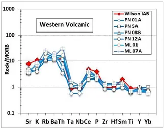
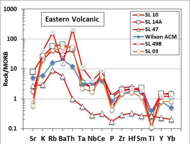
To get more evidences in revealing the origin of the rocks, all analytical results of the selected trace elements will be plotted in spider diagrams. For the purpose, the results have been normalized using method introduced by Pearce (1983). Plot of the western volcanic in trace elements spider diagram is demonstrated in the Figure 7. The trace elements patterns of the western volcanic show insignificant enrichment in incompatible elements (Sr, K, Rb, Ba, Th), but almost similar abundance in compatible elements (P, Zr, Hf, Sm, Ti, Y, Yb) compared to Mid Oceanic Ridge Basalt (MORB).
Figure 7. Plot of the western volcanic showing matched pattern with the rocks derived from island-arc setting, represented by Island Arc Basalt (Wilson, 1989) These patterns show strong similarity with the
pattern of Island Arc Basalt (taken from Wilson, 1989) and directly confirm that the western volcanic of Central Sumatera is subduction
related volcanic derived from island-arc tectonic setting. It means, the western part of the island is not continental component, but island-arc fragment.
Table 2. Analytical Trace Elements results of volcanic from Central Sumatera (in ppm)
Sample Sr K Rb Ba Th Ta Nb Ce P Zr Hf Sm Ti Y Yb
SL 22A 314 31619 99 677 10.7 0.7 11 69.3 1169 290 7.3 7 4389 46 5
SL 26 352 19403 80 365 7.7 0.3 4 43.8 887.8 144 4.2 5.4 4528 30 3.5
SL 28D 165 33494 134 454 6.4 0.4 3 26 397.5 112 3.4 3.1 1910 21 2.6
SL 38 318 17716 77 311 7.8 0.3 4 34.9 618.5 120 3.5 3.6 4282 18 2
SL 42 308 20587 110 407 12.7 0.5 5 53.8 707.4 169 4.9 4.5 3642 24 2.5
SL 43B 332 17060 79 359 8.6 0.5 6 51.7 840.2 170 4.9 5.6 4790 25 2.5
SL 03 68 35591 82 1033 10.8 0.4 6 53.1 221.4 133 3.9 3.7 984.6 24 2.7
SL 04 516 20495 63 450 3.1 0.2 3 36.9 1916 84 2.3 3.6 3811 15 1.7
SL 05 697 14860 51 350 3.2 0.2 3 25.4 1237 108 2.9 2.8 3081 14 1.8
SL 10 209 25091 84 617 8.9 0.7 8 55.5 675.9 211 6.1 5.7 2283 43 5.2
SL 14A 967 31671 115 1300 9.4 0.6 8 68.7 585.5 181 5.1 7.7 3296 45 4.7
SL 15 330 15782 53 415 6.2 0.3 4 41.2 726 112 2.8 5.8 3875 75 6.8
SL 18A 366 15734 62 380 6.4 0.4 4 46.8 809.9 142 3.9 6.4 3545 40 3.9
SL 32 366 17031 61 335 6.6 0.2 3 35.8 891.7 131 3.6 4 4456 21 2.4
SL 35 412 13417 43 376 6 0.3 4 45.7 1093 128 3.3 5.4 4558 34 3.1
SL 41 427 16006 61 414 7.2 0.6 7 44.7 891.2 127 3.3 3.7 4239 21 2.3
SL 47 330 3659 18 114 0.2 0.1 1 3.2 89.55 26 0.8 0.9 2410 7 0.7
SL 49B 104 49546 323 316 41.3 2 14 86.6 264.7 164 5.2 6.3 1066 37 4
PN 01A 418 10907 25 411 1.2 0.1 2 21.8 1121 81 2 3.3 5404 24 2.4
PN 5A 429 5888 21 218 2.3 0.2 4 28.5 1156 108 3 4.1 5725 28 3.3
PN 12A 578 4959 40 277 0.7 0.2 3 19.4 1035 74 1.9 3 5774 20 2.2
PN 08B 494 9521 23 323 3.3 0.2 4 47.5 1342 125 3.3 5.3 6331 26 2.7
ML 01 513 9521 28 237 3.3 0.3 4 34.7 1342 106 3 4.5 6331 22 2.3
©2014 Pusat Penelitian Geoteknologi
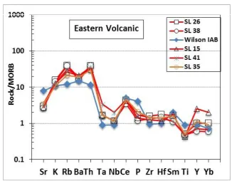
Figure 9. Plot of five samples of eastern volcanic showing strong similarity in pattern with the island-arc group.
Samples from the eastern volcanic are also Figure 10. Plot of five samples of eastern volcanic showing continental character and
matched with the pattern of Active Continental Margin, represented by ACM (taken from Wilson, 1989)
©2014 Pusat Penelitian Geoteknologi
plotted in spider diagrams and they show several different pattern. These various patterns indicate that the tectonic environment has been changed gradually eastwards, from island-arc character to continental character. Eight samples of eastern volcanic show very similar pattern with the arc segment of the Central Sumatera.
Plot of other 10 samples from eastern volcanic group in spider diagram give a good confirmation about the continental character of the region, although they show various enrichment in incompatible elements and depletion in compatible elements (figure 10 and 11). However, the unusual sample (SL 47) shows different pattern than the continental group
(Figure 11). The rock is slightly enriched on incompatible elements but very depleted on compatible elements and it confirms strongly that this rock is not derived from magma in the Central Sumatera. The evidences found through the geochemical signatures of volcanic in Lampung and Bengkulu regions (Zulkarnain, 2011, 2012) are strongly confirmed by the geochemical patterns of major and trace elements of the volcanic in Central Sumatera. However, to get more supporting data and reasons for that, it is still necessary to find out more evidences from their REE. All 18 samples of the eastern volcanic were analyzed chemically for REE and the results are given in the Table 3.
Table 3 shows various content of the REE among the western and eastern volcanic groups itself and between the two groups. No significant different content can be recognized based only on their elements content, except one sample, the unusual sample (SL 47). The last sample contains very low abundance on all rare earth elements compared to other samples.
To get more clear comparison of the REE abundance among all samples, the analytical results are normalized to chondrite and then chondrite. This pattern is typically for the island-arc environment. volcanic, although they have a small kick point at Eu element, probably resulted by effect of crystallization of plagioclase (Figure 13). This
phenomenon reflects influence trace of continental character in the island-arc environment, so that the region should be a transition zone from island-arc to continental settings.
The other five samples having also island-arc character in trace elements spider diagram (Figure 9) are also plotted in the REE spider diagram. Their patterns in the spider diagrams seem to be similar with the western volcanic, but they are more enriched on the HREE (Figure 14). The rocks are slightly high on LREE compared to the western volcanic and small kick point at Eu element still can be recognized in some of them. These patterns reflect also influence trace of continental character in island-arc environments.
Meanwhile, ten other samples of eastern volcanic are also plotted in the REE spider diagrams and the results are shown in Figure 15 and 16. Five of the ten samples are significantly enriched on
LREE (up to more than 100 times of chondrite), except sample SL 28D and they are also slightly enriched on HREE (Figure 15). However, they show similar patterns among them with clear kick points on Eu element and it is a very common mark on rocks derived from magma in continental environments.
©2014 Pusat Penelitian Geoteknologi
Four of the other five samples show similar pattern with the previous mentioned five samples, where they are significantly enriched on LREE,
showing clear kick points at Eu element and slightly enriched on HREE (Figure 16). They are completely reflecting the common signatures for Figure 13. Plot of three samples of eastern volcanic showing pattern of island-arc
environment, but with small kick point on Eu reflecting continental influences.
rocks derived from magma in the continental environment.
In the above spider diagram, it can be recognized
Figure 15. Plot of five samples of eastern volcanic showing continental character.
©2014 Pusat Penelitian Geoteknologi
clearly that one of the samples show very different pattern compared to other samples from eastern volcanic, namely the unusual sample. The rock shows a flat trend from LREE to HREE and showing ratio rock/chondrite less than 7 times chondrite. This pattern is very similar with rocks pattern derived from magma in the back-arc basin environment (Wilson, 1986).
DISCUSSION
It is already mentioned previously that the aim of this paper is to discuss the geochemical signatures of the volcanic in Central Sumatera in order to confirm whether the island-arc character of the western part of Sumatera continues from Lampung and Bengkulu to the north or it is only pseudo evidences that rise locally. Based on the trace and rare earth elements signatures found out in the volcanic in Lampung and Bengkulu regions, a preposition for the tectonic environment of the western part of Sumatera was proposed. It is believed that the western part of Sumatera is a strange fragment having long and complicated geological history before it came and collided to the eastern part of Sumatera that belongs to continental margin of Eurasia. Although the fragment nowadays has been identified consisting of several micro continents or continental fragments and covered also by Woyla Terrains, but the bedrock or the main component of the western part of Sumatera shows island-arc character. These evidences lead to understanding that Sumatera is not a homogeneous island that belongs to active continental margin of Eurasia, but it consists of two different parts where the western part is island-arc fragment and the eastern part belong to Eurasia continental margin. The evidences for island-arc character of the western part of Sumatera have been revealed through geochemical signatures of volcanic in Lampung and Bengkulu regions (Zulkarnain, 2011, 2012). Therefore, it is needed to trace and to find out such evidences in all volcanic that cropped out in the western coast of the island in order to proof the preposition.
Major elements signatures of the samples reflect the occurrences of two different tectonic environments where the rocks have been formed.
The western volcanic is typically subduction related products with island-arc character having intermediate composition in narrow range, while the eastern volcanic shows wide range composition dominated by more acidic rocks indicating subduction related volcanic with continental character (Figure 5). The clues are confirmed when the rocks plotted in the affinity diagram, where all rocks of western volcanic belong to tholeiitic type and most of the eastern volcanic classify as calc-alkaline type (Figure 6). Some of the rocks of eastern volcanic are also distributed in the tholeiitic zone and it indicates that the changing of the tectonic environment in the regions occurred gradually to the east.
The existing of two different tectonic environments in Central Sumatera is strongly supported by the geochemical signatures of trace elements. Patterns of the samples in the spider diagrams show clearly that there are two different tectonic setting where the rocks have been generated from magmas. All samples of western volcanic represent strong similar pattern with Island Arc Basalt, as well as some samples of the eastern volcanic (Figure 7, 8 and 9). It has tectonic setting, indicating influence traces of the island-arc character. Besides that, the trace elements signatures reveal also the third tectonic environment, namely back-arc basin tectonic setting to where one of the eastern volcanic samples belongs (Figure 11). These data indicate that the tectonic history of the Sumatera is not as simple as thought before. The western part of Sumatera is classified as fragment with island-arc character and it is confirmed from Lampung to Bengkulu region. However, in Central Sumatera, the fragment does not show only the island-arc character but there is evidence indicating their development into back-arc basin.
consisting of Active Continental Margin (ACM), Island-arc and Back-arc basin tectonic settings. The ACM setting are characterized by wide range of (Ta/Nb)N ranging from 1.2 to 2.8 but with ratio of (Ti/Ce)N less than 0.1, while the island-arc setting are marked by higher ratio of (Ti/Ce)N, varying from 0.15 to 0.3, but in narrow ratio of (Ta/Nb)N, between 1.0 to 1.5 (Figure 17). The back-arc basin setting is separated far away from the others and marked by high ratio of (Ti/Ce)N, up to more than 0.8.
The three identified tectonic environments are also confirmed by the geochemical signatures of rare earth elements. The patterns of REE in spider diagram for western volcanic show various enrichment in LREE but less than 100 times of chondrite and slightly enrichment on HREE, less than 30 times of chondrite (Figure 12). These patterns are matched with the rocks pattern generated in island-arc tectonic setting. The
patterns of eastern volcanic in spider diagrams figure three different patterns reflecting three different tectonic environments. The first pattern is quite similar with the western volcanic, representing the island-arc tectonic environment (Figure 13 and 14). The second one is characterized by higher enrichment on LREE and HREE than the island-arc ones and marked by clear kick points at Eu element (Figure 15 and 16). These kick points are interpreted as effect of plagioclase crystallization during magma
fractionation and it is a common feature in the continental tectonic setting. The third pattern is shown only by one sample (previously mentioned as unusual sample) where the rocks are depleted in all rare earth elements and showing almost flat pattern (Figure 16). This pattern is similar with rocks pattern derived from magmas in the back-arc basin environment.
©2014 Pusat Penelitian Geoteknologi
To get clearer figure of the three tectonic environments based on the REE, all samples are plotted in the diagram of (La/Lu)N versus (Sm/Eu)N as shown in Figure 18. The island-arc tectonic setting is characterized by relatively wide range of ratio (La/Lu)N ranging from 2.6 to 8, but they have ratio of (Sm/Eu)N less than 1.4. In the other hand, the ACM tectonic setting is represented by higher ratio of (Sm/Eu)N that is more than 1.5 and having similar ratio of
(Sm/Eu)N with the island-arc ones. Meanwhile, the back-arc basin tectonic setting is marked by low ratio of (La/Lu)N, less than 1.9.
CONCLUSION
Based on the above discussion, it can be conclude that the geochemical signatures of western and eastern volcanic in Central Sumatera have confirmed that the island-arc character of the western part of Sumatera can be traced clearly from Lampung through Bengkulu to Central Sumatera. In other words, it can be concluded that the preposition assuming the western part of Sumatera is island-arc fragment and not part of
Eurasia continental margin is still confirmed up to Central Sumatera. In Central Sumatera, the western fragment of the island does not give evidences only for island-arc character, but also Figure 18. Plot of the samples from western and eastern volcanic in Central
include indications for developing back-arc basin in the region in the past. These data have given signals that the tectonic history of Sumatera looks like to be more complicated and could be different from one segment to another segment along the western coast of the island.
ACKNOWLEDGMENT
This paper is written based on data carried out through research activities that was conducted in Research Center for Geotechnology (RCG), Indonesian Institute of Sciences that financed through the National Budget of the Republic of Indonesia. The research focus on volcanic rocks covering the western part of Sumatera Island from the most southern province (Lampung Province) up to North Sumatera Province in the north. The fieldwork and sample preparation were conducted by researchers in Hydrothermal Mineral Deposit Research Group in RCG into which I belong to. I thank so much to all colleagues in the Research Group for nice collaboration and supports during fieldwork and sample preparation activities.
REFERENCES
Barber, A.J., 2000. The origin of the Woyla Terranes in Sumatra and the Late Mesozoic evolution of the Sundaland margin. Journal of Asian Earth Sciences, 18, 713–738.
Barber, A.J. & Crow, M.J., 2003. Evaluation of plate tectonic models for the development of Sumatera. Gondwana Research, vol. 20, 1-28.
Cameron, N.R., M.C.G. Clarke, D.T. Aldis, A.A. Aspden, dan A. Djunuddin, 1980. The geological evolution of Northern Sumatra. Procc Indon. Petrol. Assoc. 9th Ann Conv. hal. 149-187.
Crow M.J., 2005. Pre-Tertiary volcanic rocks, In: Barber, A.J., Crow, M.J & Milsom, J.S., 2005, Sumatra: Geology, Resources and Tectonic Evolution, The Geological Society, London.
Curray, J.R., 1989, The Sunda Arc: a model for oblique plate convergence, Netherlands
Journal of Sea Research, vol.24, 131-140.
Fitch TJ., 1972, Plate convergence, transcurrent faults and internal deformation adjacent to southeast Asia and the western Pacific, J. Geophys. Res., 77:4432–60.
Hamilton W., 1974, Earthquake map of the Indonesian region, USGS Misc. Invest. Ser. Map I-875C classification of volcanic rocks based on the total alkali–silica diagram, Journal of Petrology, vol. 27, 745–750.
Metcalfe, I., 1998, Paleozoic and Mesozoic geological evolution of the SE Asia Region: multidisciplinary constraints and implications for biogeography, Biogeography and Geological Evolution of SE Asia, (edt) R. Hall dan J.D. Holloway, Backhuys Publishers, Leiden, The Netherlands, hal. 25-41.
Miyashiro, A., 1974, Volcanic rock series in island-arcs and active continental margins, American Journal of Science, vol.274, 321–355.
Pearce, J.A., 1983, The role of sub-continental lithosphere in magma genesis at destructive plate margins. In Hawkesworth, C.J. & Norry, M.J. (eds), Continental basalts and mantle xenoliths, Nantwich: Shiva, 230-249.
Pulunggono, A. and N. R. Cameron, 1984, Sumatran microplates, their characteristics and their role in the evolution of the central and South Sumatra basins, Procc Indon. Petrol. Assoc. 30th Ann Conv, hal. 121-144.
©2014 Pusat Penelitian Geoteknologi
Geophys.Res.,112,
B06420.doi:10.1029/2005JB003868
Wilson, M., 1989, Igneous Petrogenesis; a global tectonic approach, Unwin Hyman, London, 466pp.
Zulkarnain, I., 2007, Geochemical character of Hulusimpang Formation volcanic around Kota Agung area and their genetic implication, Jurnal JTM international edition, vol. XIV, No.3, 156-167.
Zulkarnain, I., 2011, Geochemical Evidence of Island-arc Origin for Sumatera Island; A New Perspective based on Volcanic Rocks in Lampung Province, Indonesia, Jurnal Geologi Indonesia, vol.6, No.4.