Abstract
Urban area management in developed countries such as the United States and Japan which have implemented
“Transit Oriented Development” (TOD), shows that TOD seems capable of increasing the property values and
and reducing household expenditure for transportation costs. However, applying the TOD concept in Indonesian cities such as Jakarta, Surabaya, and Medan, is a unique and considerable challenge, considering urban transportation condition in Indonesia that is far different from the conditions in urban areas in developed countries. One of important infrastructure policy issues for Jakarta and other rapidly growing cities in Indonesia is how to raise fiscal revenues through “value capture”, in which the increase the property values is due to better access and services from the existances of the railway stations. The research is based on a case study in Serpong, a neighborhood in Jakarta Metropolitan Area (JMA), Indonesia. The focus of this study is to test the basic viewpoint of TOD strategy which is how transport infrastructure such as railway stations influence the property values of a neighborhood. Following Anselin and Lozano-Gracia’s (2009) framework, this paper uses a spatial hedonic pricing model that allows to measure both “direct and in-direct effects” or “externality spillovers” from the existence of the railway stations.
Keywords:Transit oriented development, value capture, spatial hedonic pricing, railway station, Jakarta metropolitan area.
Abstrak
Pengelolaan kawasan perkotaan di negara-negara maju seperti Amerika Serikat, Jepang, dan lain-lain yang telah menerapkankonsep "Pembangunan berorientasi Transit" atau lazim disebut dengan istilah “transit oriented
development” (TOD), menunjukkan bahwaTOD tampaknya mampumeningkatkannilai propertidan danmampu mengurangi pengeluaran rumah tanggauntuk biayatransportasi.Namun demikian,menerapkankonsepTODdi kota-kotaIndonesiaseperti Jakarta,Surabaya,dan Medan,merupakan tantanganyang unik dimana kondisitata -ruang kota dan transportasi perkotaan di Indonesia yang jauh berbeda dari kondisi di daerah perkotaan dinegara-negara maju.Salah satu isukebijakan infrastruktur penting untuk Jakartadan kota-kotaberkembang pesatdi Indonesia adalah bagaimana memberikan jastifikasi meningkatkan pendapatan fiskal melalui konsep
"value capture", di mana nilai properti meningkat karena akses dan layanan yang baik dari keberadaan stasiun kereta api. Penelitian ini didasarkan pada studi kasus di Serpong, sebuah lingkungan di Jakarta Metropolitan Area (JMA), Indonesia. Fokus dari penelitian ini adalah untuk menguji sudut pandang dasar strategi TOD yaitu bagaimana infrastruktur transportasi, seperti stasiun kereta api, mempengaruhi nilai properti yang ada disekitarnya. Dengan menggunakan kerangka metodoologi yang sama dengan Anselin dan Lozano-Gracia (2009),”spatial hedonic pricing models” studi ini mampu mengukurbaik "efeklangsung” maupun “tidak langsung"dari "limpahaneksternalitas" keberadaan stasiun kereta api.
Kata-kata Kunci:Pembangunan berorientasi transit, value capture, pemodelan spatial hedonic pricing, metro-politan Jakarta.
The Influence of Railway Station on Residential Property Values-Spatial
Hedonic Approach The Case of Serpong’s Railway Station
Ibnu Syabri
Department of Urban and Regional Planning, Institut Teknologi Bandung, Jl. Ganesa No. 10 Bandung E-mail: [email protected]
Jurnal Teoretis dan Terapan Bidang Rekayasa Sipil
Jurnal Teoretis dan Terapan Bidang Rekayasa Sipil
1. Introduction
In large cities of Indonesia, travel times are generally high and increasing, and destinations accessible within limited time are decreasing. The average one
-way commute in Jakarta is 90 min. In Bandung it is 55 min. The average vehicle speed in Surabaya is 15 kilometers per hour. The average car in Jakarta is motionless in traffic for the equivalent of 50 days
292
than 15% a year - the number of vehicles doubling in
five year. The cities include Jakarta (15%), Bandung
(17%), Semarang (14%), Surabaya (18%), Medan,
Palembang, and Makassar (BPS, 2010). This problem is further worsened by the high cost of land acquisition, limited fund for the financing of the development and maintenance of transportation infrastructure in genaral and road transport in particular.
Since transit systems promote more efficient resource usage, cities in developed countries are increasingly applying transit-based strategies, called transit oriented
development (TOD) strategy, for example through the construction or extension of a rapid rail transit system along with the creation of compact, walkable neighborhoods around transit stations. The results of TOD is expected, as suggested by many, to increase transit ridership by creating destinations within a short walk of stations. It also offers residents a convenient commute to jobs, shopping and entertainment in the region. Moreover, combined neighborhood development with rail transit system, it will reduce the number of drivers on the road and encourage more compact patterns of growth by drawing residents close to rail stations (see, among others, Bowes and Ihlanfeldt, 2001; and Cervero et. al 2004).
Urban area management in developed countries such as the United States, and Japan which have implemented TOD as planning strategies for station areas (Cervero et. al 2004; Cervero and Kockelman, 1997), shows that TOD seems capable of increasing urban economic growth, increasing financial resources for the maintenance of transportation infrastructure, and reducing household expenditure for transportation cost. However, applying the TOD strategy in Indonesian cities such as Jakarta, Surabaya, and Medan, is a unique and considerable challenge, considering urban transportation condition in Indonesia that is far different from the conditions in urban areas in developed countries.
The research is based on a case study of Jakarta Metropolitan Area (JMA), Indonesia. This city is the financial and business hub of Indonesia and a center of various governmental, social, economical, cultural as well as political activities. The focus of this study is to test the basic viewpoint of TOD strategy which is how the existance of transport infrastructure and systems in general, and railway stations in particular influence the property values of a neighborhood in JMA.
Specifically, this paper looks at gains in accessibility as an opportunity for a comprehensive land value capture mechanism collected as a funding source towards the infrastructure operation and maintenance of the railway itself. This would reduce the burden on the public sector to raise the money for light rail network development, and distribute it across a larger set of beneficiaries. One way to investigate this argument is to
measure the premium that homeowners are willing to pay to be close to a rail station. If transit service provides a real economic benefit, the value of that benefit should be capitalized into the price of nearby parcels (see Bowes and Ihlanfeldt, 2001; and Billings, 2011; for recent reviews). Hedonic analysis of house rents conditional on railway station access will therefore yield estimates of the contribution of individual housing unit characteristics and thus the willingness-to-pay (WTP) of residents for those marginal benefit of a uniform improvement in parking and traffic congestion nearby railway station can be estimated and measured from traditional hedonic housing-price models. The more recent development of
spatial-hedonic housing price models (see Anselin and
Lozano-Garcia, 2009, among others), however,
introduces a spatial dimension to this model that may capture more accurate estimation.
Following Anselin and Lozano-Gracia’s (2009)
framework, this paper uses a spatial hedonic pricing model that allows to measure both “direct effects and externality spillovers” from the improvement of the railway station. Georeferenced information of the house location is collected using GPS (global positioning system) and applied it to estimate the valuation of access and amenity of the railway station. The remainder of the paper is structured as follows. The next section discusses the TOD and mobility in Indonesia in general. The use of hedonic models for valuation purposes and the estimation strategy are discussed in Section 3. The data used in this analysis and estimation results are described in Sections 4. The marginal willingness to pay for the access improvement to railway station is discussed in Section 5. The paper is concluded in Section 6.
2.
Mobility
and
Transit
Oriented
Development
Mobility can be defined as a set of movements that are linked to specific urban activities and their land use
(i.e, immobility factors). According to Rodrigue et. al (2009, p. 212) each type of land use involves the
generation and attraction of a particular array of movements. This relationship is complex, but is linked to factors such as repetition, income, urban form, spatial accumulation, level of development and technology.
conditions of local demand that far exceed the capacity of facilities, the incompatibility of urban structure with increased motorization, lack of adequate road maintenance and limited agreement among responsible officials as to appropriate forms of approach to the problem (see Gakenheimer, 1999; among others). Mobility in Jakarta is declining even more for public transport users. Gakenheimer claims that in many developing countries such as Jakarta this is largely because transit routes characteristically follow the highest volume arteries, those most badly affected with congestion. Further, transit networks are usually dominantly radial, not permitting cross-town
avoidance of congestion. Finally, transit users are not able to follow trip destinations that are shifted into the higher auto-accessible locations at the periphery
because the transit network does not serve them. A policy emphasis on expanding the road system rather than improving transit often makes this situation worse. For these reasons, it is very important to provide interventions to alleviate the mobility burden of the urban households by reducing their commuting time and monetary costs. One approach is using TOD strategy.
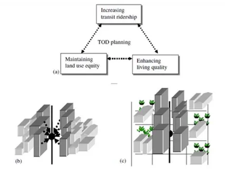
Figure 1. TOD Concepts (Lin and Gau, 2006)
In this paper, TOD is terms used to describe immobility factors as an approach to neighborhood development. Such strategies are emerging across the developed countries showing how transportation systems in general and railway stations in particular can effectively be integrated with neighborhood design principles. The goal of this concept is to reduce automobile dependency and automobile dominance. The concept of TOD applied in this study is inspired by the work of Lin and Gau (2006). Thi is based on transport sustainability displayed as illustrated in
Figure 1 (a). The first is optimizing railway system
ridership. Increased railway utilization enhances both railway operation and resource utilization efficiency. Optimizing railway system ridership, thus, helps economic sustainability. Land use density, around station areas, is a critical factor in increasing subway system ridership, as illustrated in Figure 1 (b). The
second objective is enhancing the quality of the living environment around station areas. Public facilities
(such as parks, squares, green fields, schools, and so
on) play an important role in determining living environment quality, as shown in Figure 1 (c); living
294
an improved living environment stimulate land values. Thus, the value of that improved living condition should be capitalized into the price of nearby parcels.
3. Spatial Hedonic Pricing Models
It has long been known that residential property values depend on not only the attributes of the proerty itself but also the current levels of residential amenities or local public goods such as access to a railway station. That dependence provides a way to measure households’ willingness to pay forsuch amenities or public goods. Numerous studies and and comprehensive reviews have discussed this valuation through methods such as contingent valuation
(Whittington, 2002), discrete choice analysis (Earnhart,
2002) and hedonic specifications (Palmquist, 2005). However, some of characteristics of such as the availability of public services or access to transportation services are not readily observed, but their influences may be captured using spatialeconometric techniques. Among these techniques is the use of “spatial lags”, also known as spatial autoregression, in which the prices or characteristics of neighboring properties are explicitly included in hedonic regressions (Anselin, 2002).
The literature on the influence of railway station access on residential property values in Asia in general is not nearly as well examined, with Thailand as an exception. Recently, Chalermpong (2007) studied the influence of resediential property values, and Chalermpong and Wattana (2010) studied the impact of access to railway station not on residential property but their study on commercial property values have provided useful insight to develop a similar model for Indonesia. However, a few researchers have applied spatial econo-metric technique to hedonic modeling of residential property values in Asia (Kim and Zhang (2005); Shin et al. (2007); and recently Chalermpong and Wattana
(2010)).
Since the property valuation of dwelling units inherently may embrace spatial dimension or spatial pattern, the house prices could be considered as segmented if housing characteristics are different across submarket and there are some informational or geographical barriers between submarkets. If the market under investigation is really segmented and ignored, the potential bias and loss of efficiency will happpen in the estimation of hedonic models. Recent empirical econometric work has addressed these potential bias and loss of efficiency when this spatial dimension is ignored in the estimation of hedonic models (Anselin and Lozano-Gracia, 2009).
Different from the work of Chalermpong (2007), we assume that access distance to the railway station are capitalized in the value of a dwelling unit. Hedonic
analysis of house rents conditional on service access will therefore yield estimates of the contribution of individual housing unit characteristics and thus the willingness-to-pay (WTP) of residents for those
characteristics. This study hypothesizes that housing market of Serpong is segmented due to the geographical barrier, i.e. division of the neighborhood by the railway line. In order to test this hypothesis, this paper follows a spatial-hedonic model formulated by
Anselin and Lozano-Garcia (2009) to estimate the
benefits of a uniform improvement of access to a railway station in Serpong, Jakarta. The preferred model is a spatial-lag specification of the following
form:
log p= Xβx + Tβt + ρW log p+ ε (1)
where p is a vector of housing prices, T is a vector of transportation access to the railway line, X is a matrix of other covariates, W is a spatial-weight matrix, ε is an
error vector, and ρ, βx,βt are parameters to be estimated.
The spatial-lag specification in (1) can be expressed in
reduced form, provided ρ<1, by solving for log(p):
log p= (I – ρW)-1 Zβ + u
(2)
where I is an identity matrix with dimensions equal to the number of locations, Z=[X, T] is the
matrix of all covariates, β = (β’x , β’t) is the vector of
their coefficients, and u = (I – ρW)-1 ε is a vector of
spatially-weighted error terms.
From (2), the marginal effects on prices of a change in
S is given by the matrix
( log p) / (T)= βt . (I – ρW)-1 (3)
where both log(r) and T are vectors. In the case of a uniform improvement in T by amount θ, the total effect on price at each location is given by the vector
( log p) / ( θ) = βt . (I – ρW)-1 (4)
This expression reflects the direct and indirect price changes induced by the uniform access improvement. The direct effect, βSpi, estimates the amenity value of a
marginal transportation access improvement at each location, while the indirect effect is βtpi multiplied by
[(1-ρ)-1] = ρ/(1-ρ).
In this study, the valuation of rail station accessibility is computed from the parameter estimates. In a hedonic framework, the marginal willingness-to-pay (MWTP)
is defined as the derivative of the hedonic price equilibrium equation with respect to the characteristic of interest, in this case access to rail station. In a non
-spatial log-linear model, the MWTP equals the
estimated coefficient for the walk distance variable
MWTPθ = ( p) / ( θ) = βθ. p, (5)
where θ is WDIST
For the spatial lag model, the total effect consists of the direct effect and a spatial multiplier. This spatial multiplier effect needs to be accounted for to accurately compute the MWTP (see Anselin and Lozano-Garcia, 2009). For a uniform change across all
observations, the multiplier effect is:
MWTPθ = ( p) / ( θ) = βθ. p.(1/(1 – ρ)), (6)
with ρ as the estimate of the spatial autoregressive coefficient.
4. Study Area, Data, Variables and Results
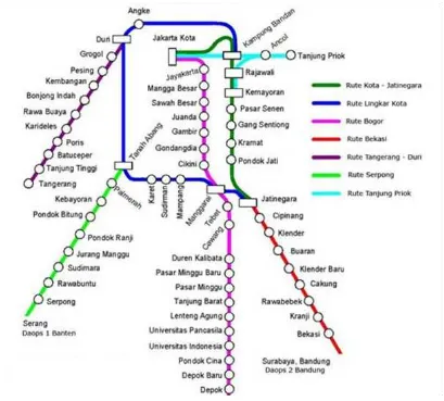
4.1 The study areaThe study area is the Southwest corridor, connecting southwest of Jakarta (Serpong station) with the central bisnis areas (Dukuh Atas station) of Jakarta. Figure 2
shows the general spatial structure of the railway lines. Over the past few decades, the Jakarta government has actively pursued a decentralization policy to
redistrib-ute population and economic activities away from the core metropolitan areas. The development of new towns such as Bintaro city, Tangerang city, Depok city, and Bekasi city since 1990 was a major means to achieve this decentralization goal. Up to 2010, four new towns have been developed in the Jakarta metro-politan area. Transport infrastructural development played a critical role in supporting the population decentralization. As of 2010, all of were accessible by the heavy railway system. The key importance of the heavy railway system in JMA can be shown by the figure that as much as 33% of the total public transport passenger journeys were carried on the system (Dishub, 2010).
4.2 Data
Serpong is located at the southwest of the outer-ring
road, and its neighborhoods is served by the green line and have primarily market-based residential housing.
Serpong’s station is established in 2007 featuring medium densities, local retail uses, and good cycling infrastructure. As shown in Figure 3, Serpong is also
a mixed-use, transit-oriented neighborhood with
296
Figure 3. Serpong station, its access path, and the sampling areas
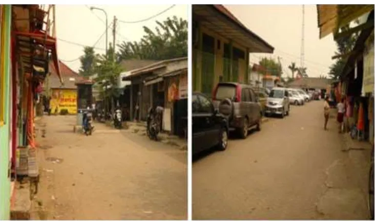
Access to the station is by a rather narrow dead-end
road, lined with small houses and retail stores on the
both sides of the street. Figure 4 shows that the access
to the station is only from a narrow gate and difficult since the space in front of the station is limited to a microlette parking line, and no space reserved for buses. Developments will then be necessary in front of the station, such as clearing the street vendors to allow a suitable drop-off point for buses and microlettes.
A sample of 197 houses from the area within 1000 meter radius of the train station is used for the analysis. In this paper, I also use geographically referenced information that includes 197 sample. This survey was conducted between April and June 2011. The data collected for the property valuation of the dwelling unit is problematic, since most recorded sales do not reflect actual transaction amounts. In order to obtain a more accurate valuation of housing services, this study follow the same approach that Anselin and Lozano
-Garcia (2009) did in India. The surveys asked households to report what they believe would be the market rent for a similar house in their neighborhood. This variable is not based on an actual transaction, but it represents an estimated value reported by the owner
-occupier of the dwelling unit. The survey team also checked these values to actual transaction data obtained from a local real estate agent. However, in the data set there may be some potential errors the due to it is characterized by the subjectivity that refers to the way of advertising and the object of the property being advertized. Therefore, the data potentially has errors in variables.
GIS is employed to calculate a spatial-related variable:
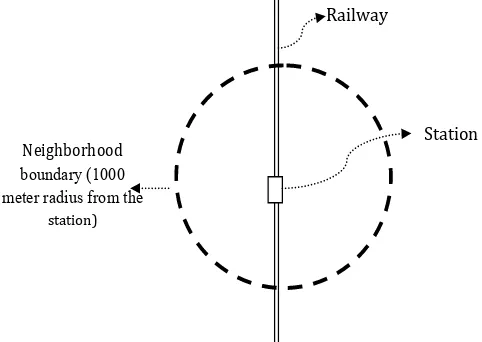
distance to the railway station. This is the focus variables in this study. Figure 5 illustrates the
neighborhood environment surrounding a railway station. The neighborhood may have residencial, commercial zones, and public facilities such schools, hospitals, sport centers to serve people who live there. All transit riders within the boundary use this station to access the railway by walk or feeders such as motorcycle taxi, microbus, and other transit modes.
Neighborhood
Figure 5. A typical neighborhood with a rail station
House characteristics such as lot size, floor size, number of rooms, number of bathrooms, and the availability of transportation services are also contained in the survey. The data to represent the availability of bus and microbus transit for short trip from home to station is estimated using the daily schedules of bus and microbus routes that pass through the areas. These data are available in digital format that can be processed using a geographical information system software. The data for availability of becak, ojek, and taxi are collected from the household survey based on their experience living in the neighborhood. The households was asked for approximated time of getting those feeders. The variables representing those feeders are set to 1 the waiting time is less than 15 minute and 0. Variables definitions and descriptive statistics are presented in the Table 1 with variables describing neighborhood,
transportation facilities and services and environmental condition.
4.3 Regression results
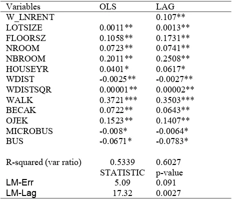
Using Geoda statistical software developed by Anselin and Syabri (2006), the spatial regressions discussed above, based on the contiguity spatial weights matrix, is estimated. Table 2 shows that most
of the variables are significant at least at the 0.05 level, one exception is the house age. That is to say, prices tend to decrease with age, but much older houses may enjoy a price premium. Another possible explanation is that old houses are more likely to have been renovated.
298
Variable Names Description of variables Mean Std. Dev Min Max
Dependent Variable
RENT House rent (in thousand Indonesian Rupiah, IDR) 6,544.1 6,926.4 2,400 84,000
LNRENT Log of estimated house rent 15.69 15.75 14.69 18.25
House Characteristics
W_LNRENT Spatial lag variable of log house rent
LOTSIZE Lot size in sqr. Meter 123.52 510.49 60 1,300
FLOORSZ Floor size in sqr. Meter 90.30 890.20 45 2,400
NROOM Number of rooms 2.73 1.10 1.00 12.00
NBROOM Number of bathrooms 1.80 0.56 1.00 7.00
HOUSEYR Age of House 3.20 3.11 1.00 20.00
WDIST Walking distance to train station (within 1000 meter radius) 103.63 315.04 85 703
WALK The availability pedestrian walk to train station 0.217 0.414 0 1
The availability of transportation feeder modes from home to station (1 if < 15 minute waiting; 0 otherwise)
BECAK The availability of Becak 0.134 0.342 0 1
OJEK The availability of motorcycle taxi or Ojek 0.433 0.498 0 1
MICROBUS The availability of microbus / opelet route to train station 0.309 0.464 0 1
BUS The availability of bus route to train station 0.463 0.501 0 1
Table 1. Description of variables and descriptive statistics ofSerpong Station Neighborhood (N=197)
Variables OLS LAG
R-squared (var ratio) 0.5339 0.6027
STATISTIC p-value
LM-Err 5.09 0.091
LM-Lag 17.32 0.0027
Table 2. Coefficient estimates in hedonic equation
Notes: *** Significant at 1%; ** Significant at 5% * Significant only at 10%
Building square meter and lot size are significant at the 0.05. Housing price goes up with increased house size but at a declining rate. Housing prices tend to go up with the availability of pedestrian walk and motorcycle taxi or Ojek. The coefficient for the spatial lag is above 0.107 and very significant. The LM statistic in the lag model confirms the presence of remaining residual spatial autocorrelation.
The log of estimated house rent is used as the dependent variable. The walking distance from home to the rail station and its square term (the accessibility effect), WDIST and WDISTSQR respectively, are used for the main policy variable of interest. The estimation results show the expected patterns in terms of signs and significance. As expected, the house characteristics have positive and significant effects.
On average, the walking distance from houses to the station is around 103.63 meter. The obvious interpretation is that the housing price decreases when its distance to the LRT station increases, but at a declining rate because the effect of the square term of distance to station increases at an accelerated rate. The minimum price is reached at 703 meters away from stations, which implies a 17.3% price difference. After that, the estimated prices start to go back up, but within the actual distance for all houses in the sample.
The total effect of the station on the house values, this study reports the results for a queen spatial weights matrix and with standard errors based on the classic form, MWTP are estimated for a change in walk distance for accessing the station. This study finds some difference between the OLS estimate and the result from the LAG model, in general, with the LAG estimate being larger. The MWTP show the OLS
-based estimate as 16,360 IDR, whereas the spatial lag model based estimate is 18,320 IDR. For example, the direct effect at 100 meters away from stations, each additional meter further away from the station will result in a 16,360 IDR (i.e, direct effect) and a 18,320 IDR (i.e, total effect) decrease in price for an average price house at 6,5 million IDR.
5.
Conclusion
2. The results of this study confirm that our hypothesis that the rail station has positive effect
(i.e, accessibility effect) on the property values,
which implies a declining price gradient as one moves away from the station. By incorporating neighborhood effects in spatial hedonic estimates of the capitalization of better access distance to rail station, we show that total benefits that include direct effects and neighborhood multipliers are considerably higher than estimates from nonspatial estimation. Specifically, the spatial estimates exceed standard MWTP estimates by over 10 percent.
3. This research has important policy implications. The obtained econometric results suggest that residents in Serpong do value access to the rail
Geographical Analysis, Vol. 38 (1),pp. 5–22 Anselin, L. and Lozano-Gracia, N., 2009, Spatial
Hedonic Models. In T.C. Mills and K.
Patterson (Eds), Palgrave Handbook of Econometrics, Volume 2: Applied Econometrics, pp. 1213-1250. Basingstoke:
Palgrave Macmillan.
Billings, S.B., 2011, Estimating the Value of a New Transit Option, Reg. Sci. Urban Econ. Article
in Press.
Beron, K.J., Hanson, Y., Murdoch, J.C., and Thayer, M.A., 2004, Hedonic Price Functions and Spatial Dependence: Implications for the Demand for Urban air Quality. In Anselin, L.,
Florax, R.J., and Rey, S.J., editors, Advances in Spatial Econometrics: Methodology, Tools and Applications, pp. 267-281. Springer
-Verlag, Berlin.
Bowes, D.R., Ihlanfeldt, K.R., 2001, Identifying the Impacts of Rail Transit Stations on Residential Poperty Values. Journal of Urban Economics,
50 (1), pp. 1–25.
D.E., W.B. Allen, and Tang F., 1976, Impact of Rapid Rail Transit on Residential-Property Sales Prices, in ‘‘Location and Regional Space
Development’’ M Chatterji, Ed., Pion, Ltd., London
BPS, Biro Pusat Statistik, 2010, Sensus Penduduk 2010
Cervero, R., Murphy, S., Ferrel, C., Goguts, N., Tsai, Y., Arrington, G.B., Boroski, J., Smith
-Heimer, J., Golem, R., Peninger, P., Nakajima, E., Chui, E., Dunphy, R., Myers, M., McKay, S., Witenstein, N., 2004, Transit-Oriented Development in the United States: Experiences, Challenges, and Prospects,
Transit Cooperative Research Program (TCRP) Report 102. Washington: Transportation Research Board, National Academy Press. Cervero, R.. 1994, Transit-based Housing in
California: Evidence on Ridership Impact.
Transport Policy, Vol. 3, pp. 174–183. Land Use in Developing Countries: A Hedonic Study of Residential Property Prices in Bangkok, Thailand, Transportation Research Record: Journal of the Transportation Research Board, No. 2038, pp. 111-119.
Chalermpong, S., and Wattana, K., 2010, Rent Capitalization of Access to Rail Transit Stations: Spatial Hedonic Models of Office Rent in Bangkok, Journal of the Eastern Asia Society for Transportation Studies, Vol. 8, pp.
926-940.
Dishub, DKI Jakarta, 2010, Laporan Tahunan Transportasi
Earnhart, D., 2002, Combining Revealed and Stated Data to Examine Housing Decisions Using Discrete Choice Analysis. Journal of Urban Economics, 51, pp. 143-169.
Gakenheimer R., 1999, Urban Mobility in the Developing World, Transportation Research
Part A, 33, pp. 671-689
http://maps.google.com/maps?hl=en&tab=ml
Kim, J., and Zhang, M., 2005, Determining Transit’s Impact on Seoul Commercial Land Values: An Application of Spatial Econometrics,
300
Lin, J.J., and Gau. C.C.. (2006, A TOD Planning Model to Review the Regulation of Allowable Development Densities Around Subway Stations. Land Use Policy 23(3): 353-360.
Nations Online, 2011, "First, Second and Third
World". http://www.nationsonline.org/ oneworld/third_world_countries.htm.
Retrieved November 2011.
Palmquist, R.B., 2005, Property Value Models, in Handbook of Environmental Economics,
Volume 2. Karl-Göran Mäler and Jeffery
Vincent eds. Amsterdam: North Holland Press. PT Kereta Api Devisi Jabodetabek, http://
id.wikipedia.org/wiki/KRL_Jabotabek, last accessed July 1, 2011
Rodrigue J.P, Comtois C., Slack, B., 2009,
The Geography of Transport Systems,
Routledge, 352 pages.
Shin, K., Washington, S., and Choi, K., 2007, Effects of Transportation Accessibility on Residential Property Values: An Application of Spatial Hedonic Price Model in the Seoul Metropolitan Area. Washington, D.C:
Presented at the 86th Annual Meeting of the Transportation Research Board.
Whittington, D., 2002, Improving the Performance of
Contingent Valuation Studies in Developing Countries. Environmental and Resource
