Open Geospatial Consortium
Submission Date: 2015-02-10
Approval Date: 2015-05-29
Publication Date: 2016-01-29
External identifier of this OGC® document:http://www.opengis.net/doc/BP/dgiwg-wms1.3-profile/2.0
Internal reference number of this OGC® document: OGC 09-102r3
Version: 2.0
Category: OGC® Best Practice
Editors: Stefan Strobel, Dimitri Sarafinof, David Wesloh, Paul Lacey
DGIWG – Web Map Service 1.3 Profile – Revision
Copyright notice
Copyright © 2016 Open Geospatial Consortium
To obtain additional rights of use, visit http://www.opengeospatial.org/legal/.
Warning
This document defines an OGC Best Practices on a particular technology or approach related to an OGC standard. This document is not an OGC Standard and may not be referred to as an OGC Standard. It is subject to change without notice. However, this document is an official position of the OGC membership on this particular technology topic.
Document type:
OGC Best Practice
Document subtype:
Profile
License Agreement
Permission is hereby granted by the Open Geospatial Consortium, ("Licensor"), free of charge and subject to the terms set forth below, to any person obtaining a copy of this Intellectual Property and any associated documentation, to deal in the Intellectual Property without restriction (except as set forth below), including without limitation the rights to implement, use, copy, modify, merge, publish, distribute, and/or sublicense copies of the Intellectual Property, and to permit persons to whom the Intellectual Property is furnished to do so, provided that all copyright notices on the intellectual property are retained intact and that each person to whom the Intellectual Property is furnished agrees to the terms of this Agreement.
If you modify the Intellectual Property, all copies of the modified Intellectual Property must include, in addition to the above copyright notice, a notice that the Intellectual Property includes modifications that have not been approved or adopted by LICENSOR.
THIS LICENSE IS A COPYRIGHT LICENSE ONLY, AND DOES NOT CONVEY ANY RIGHTS UNDER ANY PATENTS THAT MAY BE IN FORCE ANYWHERE IN THE WORLD.
THE INTELLECTUAL PROPERTY IS PROVIDED "AS IS", WITHOUT WARRANTY OF ANY KIND, EXPRESS OR IMPLIED, INCLUDING BUT NOT LIMITED TO THE WARRANTIES OF MERCHANTABILITY, FITNESS FOR A PARTICULAR PURPOSE, AND NONINFRINGEMENT OF THIRD PARTY RIGHTS. THE COPYRIGHT HOLDER OR HOLDERS INCLUDED IN THIS NOTICE DO NOT WARRANT THAT THE FUNCTIONS CONTAINED IN THE INTELLECTUAL PROPERTY WILL MEET YOUR REQUIREMENTS OR THAT THE OPERATION OF THE INTELLECTUAL PROPERTY WILL BE UNINTERRUPTED OR ERROR FREE. ANY USE OF THE INTELLECTUAL PROPERTY SHALL BE MADE ENTIRELY AT THE USER’S OWN RISK. IN NO EVENT SHALL THE COPYRIGHT HOLDER OR ANY CONTRIBUTOR OF INTELLECTUAL PROPERTY RIGHTS TO THE INTELLECTUAL PROPERTY BE LIABLE FOR ANY CLAIM, OR ANY DIRECT, SPECIAL, INDIRECT OR CONSEQUENTIAL DAMAGES, OR ANY DAMAGES WHATSOEVER RESULTING FROM ANY ALLEGED INFRINGEMENT OR ANY LOSS OF USE, DATA OR PROFITS, WHETHER IN AN ACTION OF CONTRACT, NEGLIGENCE OR UNDER ANY OTHER LEGAL THEORY, ARISING OUT OF OR IN CONNECTION WITH THE IMPLEMENTATION, USE, COMMERCIALIZATION OR PERFORMANCE OF THIS INTELLECTUAL PROPERTY.
This license is effective until terminated. You may terminate it at any time by destroying the Intellectual Property together with all copies in any form. The license will also terminate if you fail to comply with any term or condition of this Agreement. Except as provided in the following sentence, no such termination of this license shall require the termination of any third party end-user sublicense to the Intellectual Property which is in force as of the date of notice of such termination. In addition, should the Intellectual Property, or the operation of the Intellectual Property, infringe, or in LICENSOR’s sole opinion be likely to infringe, any patent, copyright, trademark or other right of a third party, you agree that LICENSOR, in its sole discretion, may terminate this license without any compensation or liability to you, your licensees or any other party. You agree upon termination of any kind to destroy or cause to be destroyed the Intellectual Property together with all copies in any form, whether held by you or by any third party.
DGIWG – 112
DGIWG – Web Map Service 1.3 Profile – Revision
Document type: Standard
Document subtype: Implementation Profile
Document date: 16 November 2015
Edition number: 2.1.0
Supersedes: This document supersedes DGIWG – 112 Ed. 2.0.0, Web Feature Service (WFS) Profile, dated 04 February 2015.
Responsible Party: DGIWG
Audience: DGIWG participants and liaisons
Abstract: This document defines specific DGIWG requirements,
recommendations and guidelines for implementations of the ISO and OGC Web Map Service standards; ISO 19128:2005 Web Map Server Interface and the OpenGIS Web Map Server Implementation Specification 1.3.0.
Copyright: (C) Copyright DGIWG, some rights reserved - (CC) (By:) Attribution You are free:
- to copy, distribute, display, and perform/execute the work - to make derivative works
- to make commercial use of the work Under the following conditions:
- (By:) Attribution. You must give the original author (DGIWG) credit.
- For any reuse or distribution, you must make clear to others the license terms of this work.
Any of these conditions can be waived if you get permission from the copyright holder DGIWG.
Your fair use and other rights are in no way affected by the above.
Table of Contents
1. INTRODUCTION ... 1
2. SCOPE ... 2
3. CONFORMANCE ... 2
4. NORMATIVE AND INFORMATIVE REFERENCES ... 2
4.1. NORMATIVE REFERENCES ... 2
4.2. INFORMATIVE REFERENCES ... 3
5. TERMS, DEFINITIONS, AND ABBREVIATIONS ... 3
5.1. DEFINITIONS ... 3
5.2. ABBREVIATIONS ... 3
6. DGIWG WMS PROFILE (NORMATIVE) ... 6
6.1. INTRODUCTION ... 6
6.2. NORMATIVE REQUIREMENTS ... 6
6.3. NON-NORMATIVE RECOMMENDATIONS FOR IMPLEMENTATION ... 8
6.4. SERVICE TYPE ... 9
6.5. BASIC SERVICE ELEMENTS ... 9
6.5.1. VERSION NUMBER ... 9
6.5.2. BINDING ... 9
6.5.3. OUTPUT FORMATS ... 9
6.5.4. COORDINATE SYSTEMS ... 10
6.5.5. REQUEST PARAMETER RULES ... 11
6.6. OPERATIONS ... 12
6.6.1. GETCAPABILITIES OPERATION REQUEST ... 12
6.6.2. GETCAPABILITIES OPERATION RESPONSE ... 12
6.6.3. GETMAP OPERATION REQUEST ... 17
6.6.5. GETFEATUREINFO OPERATION REQUEST ... 19
6.6.6. GETFEATUREINFO RESPONSE ... 21
7. QUALITY OF SERVICE ... 22
7.1. PERFORMANCE ... 22
7.2. CAPACITY ... 22
7.3. AVAILABILITY ... 22
ANNEX A – ABSTRACT TEST SUITE ... 23
A.1 DGIWGSERVICE TYPE ... 23
A.1.1 DGIWG SERVICE TYPE ... 23
A.1.2 DGIWGWMSBINDING ... 23
A.1.3 DGIWGWMSOUTPUT FORMAT ... 23
A.1.4 DGIWG WMS CRS ... 24
A.1.5 DGIWGWMSREQUEST PARAMETERS -EXCEPTIONS ... 24
A.2 DGIWGWMSOPERATIONS ... 24
A.2.1 DGIWG WMS GETCAPABILITIES REQUEST ... 24
A.2.2 DGIWGWMSGETCAPABILITES RESPONSE ... 24
A.2.3 DGIWG WMS GETMAP REQUEST ... 25
A.2.4 DGIWG GETFEATUREINFO OPERATION REQUEST - FEATURE_COUNT ... 26
A.2.5 DGIWGGETFEATUREINFO OPERATION REQUEST -EXCEPTIONS ... 26
A.2.6 DGIWG WMS GETFEATUREINFO RESPONSE ... 26
ANNEX B – USE CASES ... 27
ANNEX C – EXAMPLES ... 29
ANNEX D – CLIENT REQUIREMENTS AND RECOMMENDATIONS ... 35
List of Tables
Table 1: DGIWG WMS Profile Normative Server Requirements ... 8
Table 2: DGIWG WMS Profile Non-normative Recommendations for Server Implementation8 Table 3: The parameters of a GetCapabilities request URL as per Normative Reference [1] ... 12
Table 4: Layer attributes ... 16
Table 5: GetMap request parameters ... 17
Table 6: GetFeatureInfo Request parameters ... 20
Table 7: Normative client requirements ... 36
Executive Summary
This document defines specific DGIWG requirements, recommendations and guidelines for implementations of the ISO / OGC Web Map Service standard which is based on ISO 19128:2005 Web Map Server Interface / OpenGIS Web Map Server Implementation Specification 1.3.0.
ISO 19128: 2005 defines a Web Map Service as:
"A Web Map Service (WMS) produces maps of spatially referenced data dynamically from geographic information. This International Standard defines a “map” to be a portrayal of geographic information as a digital image file suitable for display on a computer screen. A map is not the data itself. WMS-produced maps are generally rendered in a pictorial format such as PNG, GIF or JPEG, or occasionally as vector-based graphical elements in Scalable Vector Graphics (SVG) or Web Computer Graphics Metafile (WebCGM) formats."
Previous versions of the WMS standard have not been considered in this profile. The WMS Interface offers 3 Operations:
GetCapabilities (mandatory): Allows for obtaining Service Metadata GetMap (mandatory): Returns a map
GetFeatureInfo (optional): Provides additional information about features in the pictures of maps that were returned by previous GetMap requests
The WMS Implementation Specification defines two conformance classes, “Basic WMS” and “Queryable WMS”. The Basic WMS supports the mandatory GetCapabilities and GetMap operations (requests and responses) whereas the Queryable WMS supports all Basic WMS operations and the GetFeatureInfo operation. The DGIWG WMS profile mandates the implementation of the Queryable WMS.
Software implementations that claim to be conformant with the DGIWG WMS profile shall support all mandatory operations, parameters and elements of the base standard, as well as the specifically defined requirements in this document.
i.
Submitting organizations
For the Defence Geospatial Information Working Group (DGIWG):
Nation Parent organization
Germany Bundeswehr Geoinformation Centre (BGIC) France Institut Géographique National (IGN)
United States National Geospatial-Intelligence Agency (NGA) United Kingdom Defence Science and Technology Laboratory (DSTL)
ii. Revision history
This document is a revision of OGC Best Practice 09-102 DGIWG WMS 1.3 Profile and systems requirements for interoperability for use within a military environment (0.9.0). This document is also a revision of NGA.STND.0038_1.0.1_ WMS National System for Geospatial-Intelligence (NSG) OGC Web Map Service 1.3 Interoperability Standard, version 1.0.1, 22 May 2013.
iii. Future work
1. Introduction
This document defines specific DGIWG requirements, recommendations and guidelines for implementations of the ISO / OGC Web Map Service standard which is based on ISO 19128:2005 Web Map Server Interface / OpenGIS Web Map Server Implementation Specification 1.3.0.
A Web Map Service (WMS) produces maps of spatially referenced data dynamically from geographic information.
The OGC WMS Interface offers 3 Operations:
GetCapabilities (mandatory): Allows for obtaining Service Metadata GetMap (mandatory): Returns a map
GetFeatureInfo (optional): Provides additional information about features in the pictures of maps that were returned by previous GetMap requests
The WMS Implementation Specification defines two conformance classes, “Basic WMS” and “Queryable WMS”.
The Basic WMS supports the mandatory GetCapabilities and GetMap operations (requests and responses) whereas the Queryable WMS supports all Basic WMS operations and the GetFeatureInfo operation.
Software implementations that claim to be conformant with the DGIWG WMS profile shall support the Queryable WMS, as well as the specifically defined requirements in this document.
2. Scope
This document defines specific DGIWG requirements, recommendations and guidelines for implementations of the ISO / OGC Web Map Service standard which is based on ISO 19128:2005 Web Map Server Interface / OpenGIS Web Map Server Implementation Specification 1.3.0.
3. Conformance
This document establishes one conformance class: DGIWG WMS. Annex A lists the conformance abstract tests which shall be exercised on any software artefact claiming to implement a DGIWG WMS profile.
DGIWG WMS Profile conformance class defines requirements for WMS servers allowing distribution of geographic data in a military environment.
Conformance class name
Operation or behavior OGC WMS Conformance Test
DGIWG WMS Conformance Test
WMS Basic The server shall implement the Basic WMS conformance class
A.1 Basic WMS
WMS Queryable
The server shall implement the Basic WMS conformance class
DGIWG Requirement 1
A.2 Queryable WMS
DGIWG WMS DGIWG requirements
DGIWG WMS Profile (normative) Requirement 2 to Requirement 32
Annex A
4. Normative and informative References
4.1. Normative references
ID Title Reference Version
[1] OGC Web Map Service Implementation Specification 1.3.0, 2006 (same as ISO 19128)
OGC 06-042 1.3.0
[2] Best Practices for using OGC WMS with Time-Dependent or Elevation-Time-Dependent Data
12-111r1 1.0
[3] DGIWG Metadata Foundation DGIWG – 114 1.10 (7-2014)
4.2. Informative References
Title Reference Version
DGIWG WMS 1.3 Profile and Systems Requirements for Interoperability for Use within a Military Environment, STD-08-054-ED1.3, 2008.
OGC 09-102 0.9
National System for Geospatial-Intelligence (NSG) OGC Web Map Service 1.3 Interoperability Standard, 22 May 2013
GBR Web Map Service Draft Implementation Profile for WMS 1.3.0, 2012
1.0
DEU Web Map Service Draft Implementation Profile for WMS 1.3.0
1.0
UK MOD CGTS Phase 2 Research Project - Core Profile and Best Practice Guide for Use of OpenGIS Web Map Service Version 1.3.0 in support of Military Operations, 2011.
600\10012459\SPC\ 63\1
1.0
OGC NSG Plugweek Engineering Report, 2010 OGC 09-140r2
OGC TESTBED 10 CCI Profile Interoperability Engineering Report
OGC 14-021r2 3.0
OpenGIS Wrapping OGC HTTP-GET and -POST Services with SOAP - Discussion Paper; dated: 2008-01-24
OGC 07-158
NOTE: Implementers of the DGIWG WMS 1.3 Profile should verify all Reference documents for latest edition against the holdings found under http://www.dgiwg.org/dgiwg/htm/documents/documents.htm, Open Geospatial Consortium (OGC) documents are located at: http://www.opengeospatial.org/standards and https://nsgreg.nga.mil/index.jsp
5. Terms, definitions, and abbreviations
5.1. Definitions
For the purposes of this document, terms and definitions found in WMS 1.3, ISO 19128:2005 / [OGC 06-042] apply.
5.2. Abbreviations
BBox Bounding Box
CRS Coordinate Reference System CS Coordinate System
CSW Catalogue Service for the Web
DMF DGIWG Metadata Framework EPSG European Petroleum Survey Group FES Filter Encoding Specification FGDC Federal Geographic Data Committee GI Georeferenced Information
GIF Graphics Interchange Format GeoInf Geospatial Information GeoInt Geospatial Intelligence
GML Geography Markup Language GZIP GNU Zip File format
HTTP Hypertext Transfer Protocol IETF Internet Engineering Task Force
ISO International Organization for Standardization ISO/DIS ISO Draft International Standard
JPEG Joint Photographics Expert Group JSON JavaScript Object Notation
KVP Keyword Value Pairs LAN Local Area Network
MIME Multipurpose Internet Mail Extension NATO North Atlantic Treaty Organization
NGIF NATO Geospatial Information Framework NSG National System for Geospatial-Intelligence OGC Open Geospatial Consortium
OWS OGC Web Service PNG Portable Network Graphics SDI Spatial Data Infrastructure
SOAP Simple Object Access Protocol SQL Structured Query Language SVG Scalable Vector Graphics
UML Unified Modelling Language
UPS Universal polar stereographic coordinate system URI Uniform Resource Identifier
WFS Web Feature Service WMS Web Map Service WMTS Web Map Tile Service WAN Wide Area Network
WFS Web Feature Service WSDL Web Services Description Language XML Extensible Markup Language XPath XML Path Language
6. DGIWG WMS Profile (normative)
6.1. Introduction
A WMS that complies with the DGIWG WMS profile will
a) satisfy all requirements stipulated in the OGC WMS 1.3.0 Specification; b) satisfy all requirements stipulated in this document.
This profile provides advice on the implementation of the WMS so that tests can be provided to ensure objective compliance to the profile. The profile provides a “Normative Clause” to describe how each component shall be implemented. The Normative Clause defines requirements where mandatory compliance is required for attainment of conformance. However, the profile also includes optional Recommendations which may require a subjective test.
The following syntax is used to indicate the compliance requirement within the profile: Mandatory (M) – The requirement shall be implemented
Conditional (C) – Mandatory when “If” statement applies Optional (O) – Should be implemented
Note: All Requirements and Recommendations presented within this document are the result of information gathered during the DGIWG Nations questionnaire/survey process. Implementers should be aware that certain requirements are unique to a national profile such as the metadata requirements for the US shall include conformance with the NSG Metadata Framework while the DGIWG requires conformance with the DGIWG
Metadata Framework. These two metadata profiles have been synchronized to the fullest extent possible.
6.2. Normative Requirements
The Normative requirements requested by this profile are summarized in Table 1
No. Requirement Compliance
1 A DGIWG WMS server shall be compliant to the Queryable WMS conformance class.
M
2 A DGIWG WMS server shall support HTTP GET. M 3 A DGIWG WMS server shall support text/xml and text/html as
output formats for the GetCapabilities and the GetFeatureInfo Operations.
M
4 A DGIWG WMS server shall provide metadata content in a response to a "GetCapabilities" or “GetFeatureInfo” request in English language.
M
5 A DGIWG WMS server shall support the following raster formats for the GetMap operation:
image/png (Portable Network Graphics) image/gif (Graphics Interchange Format) image/jpeg (Joint Photographics Expert Group)
M
6 A DGIWG WMS server shall support the following coordinate reference systems:
CRS:84 WGS84 geographic longitude, then latitude, expressed in decimal degrees
EPSG:4326 WGS84 geographic latitude, then longitude, expressed in decimal degrees
EPSG:3395 World Mercator projection
Among the following Coordinate Reference Systems, the service shall support all those which validity zone overlaps data published by the service:
UTM projections over WGS84 (north zones)… EPSG:32601 to EPSG:32660
UTM projections over WGS84 (south zones)… EPSG:32701 to EPSG:32760
UPS projection over WGS84 (north zone)…… EPSG:32661 UPS projection over WGS84 (south zone)…… EPSG:32761 7 A DGIWG WMS server shall provide service exceptions in English
language.
M
8 A DGIWG WMS server shall support all GetCapabilities request parameters.
M
9 A DGIWG WMS server shall provide all mandatory and optional service metadata elements.
M
10 A DGIWG WMS server shall identify the highest classification level of the content accessible through the WMS service by populating the wms:AccessConstraints element.
M
11 A DGIWG WMS server shall include the following information in the abstract element of the service metadata: "This service implements the DGIWG WMS 1.3 profile version 1.0."
M
12 A DGIWG WMS server shall provide a minimum keyword list based on the DFDD groups.
M
13 A DGIWG WMS server shall provide information on the supported styles.
M
14 A DGIWG WMS server shall always provide at least one style element and that style shall be advertised even if it's only the default style.
M
15 The MaxWidth and MaxHeight shall be greater or equal to 800 pixels.
M
16 Each vector data layer's style shall have an associated legend, available as an image in one of the following formats: PNG, GIF or JPEG.
M
17 This legend shall be accessible online at the URL specified by LegendURL.
M
18 A DGIWG WMS server shall provide scale denominators for all layers it provides.
M
19 The <MinScaleDenominator> value shall always be less than or equal to the <MaxScaleDenominator> value.
M
20 If the GetCapabilities document identifies support for FeatureListURL then the list of features that are in the particular layer shall be resolvable through the provided URL.
C
21 If the GetCapabilities document identifies support for DataURL then the underlying data of the particular layer shall be resolvable through the provided URL.
C
22 A DGIWG WMS server shall provide the XML Attributes according to Table 4.
M
23 A DGIWG WMS server shall support all GetMap request parameters.
M
27 If a DGIWG WMS server provides multi-dimensional data then it shall:
0PKKJMO OC@ Q@MOD><G "G@Q<ODJI <I? O@HKJM<G 1DH@ M@LP@NO
parameters.
W%<I?G@?<O<PODGDU@?DIOC@N@K<M<H@O@MNDI<>>JM?<I>@RDOCOC@
"OGC Best Practices for using OGC WMS with Time-Dependent or Elevation-Dependent Data [2]"
C
28 A DGIWG WMS server that announces available sample dimensions in its service metadata shall resolve the corresponding parameters provided in the GetMap operation for requesting these dimensional values.
M
29 A DGIWG WMS server shall support the FEATURE_COUNT parameter to enable the increase of the number of features per layer for which the server returns information.
M
30 A DGIWG WMS server shall support the EXCEPTIONS parameter support of text/xml and text/html.
M
31 A DGIWG WMS server shall provide a response according to the INFO_Format.
M
32 A DGIWG WMS server shall return the units of measure for dimensional values returned in a GetFeatureInfo response.
M
Table 1: DGIWG WMS Profile Normative Server Requirements
6.3. Non-Normative Recommendations for
Implementation
The non-normative requirements requested by this profile are summarized in Table 2
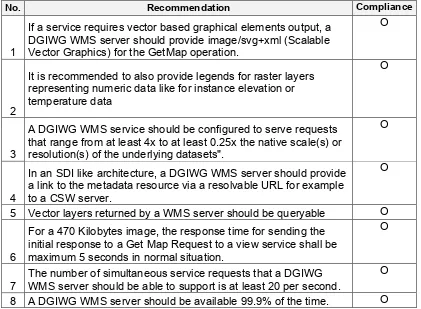
No. Recommendation Compliance
1
If a service requires vector based graphical elements output, a DGIWG WMS server should provide image/svg+xml (Scalable Vector Graphics) for the GetMap operation.
O
2
It is recommended to also provide legends for raster layers representing numeric data like for instance elevation or temperature data
O
3
A DGIWG WMS service should be configured to serve requests that range from at least 4x to at least 0.25x the native scale(s) or resolution(s) of the underlying datasets".
O
4
In an SDI like architecture, a DGIWG WMS server should provide a link to the metadata resource via a resolvable URL for example to a CSW server.
O
5 Vector layers returned by a WMS server should be queryable O
6
For a 470 Kilobytes image, the response time for sending the initial response to a Get Map Request to a view service shall be maximum 5 seconds in normal situation.
O
7
The number of simultaneous service requests that a DGIWG WMS server should be able to support is at least 20 per second.
6.4. Service Type
The OGC WMS Implementation Specification defines two conformance classes, “Basic WMS” and “Queryable WMS”. A Basic WMS supports the GetCapabilities and GetMap operations (requests and responses); a Queryable WMS includes all Basic WMS operations and an additional GetFeatureInfo operation.
Requirement 1: A DGIWG WMS server shall be compliant to the Queryable WMS conformance class.
According to this requirement a DGIWG WMS server shall support the GetCapabilities, GetMap and GetFeatureInfo operations. This requirement ensures compatibility with the base standard.
6.5. Basic service elements
The Basic service elements specify aspects of Web Map Server behavior that are independent of particular operations or are common to several operations.
6.5.1. Version number
The VERSION parameter is mandatory in GetMap and GetFeatureInfo requests. The version number is 1.3.0.
6.5.2. Binding
The OGC WMS 1.3.0 standard requires support for HTTP Get. Support for HTTP Post is optional. A SOAP binding is not defined in the standard.
Requirement 2: A DGIWG WMS server shall support HTTP GET.
6.5.3. Output Formats
The response to a Web Map Service request is always a computer file. The file may contain text, or the file may represent a map image depending on the operation. For the particular operations a DGIWG WMS server shall support the following output formats.
6.5.3.1.
Output formats for GetCapabilities and GetFeatureInfo
requests
The response to a GetCapabilities or GetFeatureInfo request is always a text file.
Requirement 3: A DGIWG WMS server shall support text/xml and text/html as output formats for the GetCapabilities and the GetFeatureInfo Operations.
Requirement 4: A DGIWG WMS server shall provide metadata content in a response to a "GetCapabilities" or “GetFeatureInfo” request in English language.
NOTE: Services can also be provided using alternative languages to English: This profile does not specify the details for implementation of multilingual services.
6.5.3.2.
Output formats for GetMap requests
The response to a GetMap request is either a raster or vector file.Requirement 5: A DGIWG WMS server shall support the following raster formats for the GetMap operation:
W image/gif (Graphics Interchange Format)
W image/jpeg (Joint Photographics Expert Group)
Recommendation 1: If a service requires vector based graphical elements output, a DGIWG WMS server should provide image/svg+xml (Scalable Vector Graphics) for the GetMap operation.
NOTE: Users should be aware that only the output formats GIF and PNG support transparency.
6.5.4. Coordinate Systems
The Web Map Service standard uses two principal classes of Coordinate Systems: a Map CS applicable to the map portrayal generated by the WMS, and a Layer CRS for a Bounding Box applied to the source data. During a portrayal operation, a WMS converts or transforms geographic information from a Layer CRS into a Map CS. In addition, a Layer may have an associated vertical, temporal or other coordinate system.
6.5.4.1.
Map CS
A Map CS is a coordinate reference system for a map produced by a WMS. A WMS map is a rectangular grid of pixels displayed on a computer screen (or a digital file that could be so displayed). The Map CS has a horizontal axis denoted i, and a vertical axis denoted j. i and j shall have only nonnegative integer values. The origin (i,j) =(0,0) is the pixel in the upper left corner of the map; i increases to the right and j increases downward.
6.5.4.2.
Layer CRS
A Layer CRS is a horizontal coordinate reference system for the geographic information that serves as the source for a map. A WMS must support at least one CRS, and maps from multiple servers may be overlaid only if all the selected servers support at least one CRS in common.
Requirement 6: A DGIWG WMS server shall support the following coordinate reference systems:
W CRS:84 WGS84 geographic longitude, then latitude, expressed in decimal degrees
W EPSG:4326 WGS84 geographic latitude, then longitude, expressed in decimal degrees
W EPSG:3395 World Mercator projection
Among the following Coordinate Reference Systems, the service shall support all those which validity zone overlaps data published by the service:
W UTM projections over WGS84 (north zones)… EPSG:32601 to EPSG:32660 W UTM projections over WGS84 (south zones)… EPSG:32701 to EPSG:32760 W UPS projection over WGS84 (north zone)… EPSG:32661
W UPS projection over WGS84 (south zone)… EPSG:32761 Implementation guidance:
<EX_GeographicBoundingBox> shall not be used as a substitute for <BoundingBox CRS="CRS:84">. If the server wishes to provide bounding box information in the CRS:84 CRS, then a separate
BoundingBox element explicitly naming CRS:84 shall be included in the service metadata.
This means that Ex_GeographicBoundingBox within a DGIWG server shall always be in CRS="CRS:84".
Some geographic information may be available at other dimensions like for instance elevation or time (3D / 4D). For example, in the case of elevation, atmospheric information like ozone concentrations, may be available at different altitudes. Similarly, geographic information may be available at multiple times, like hourly tidal information.
NOTE: Appropriate vertical and temporal coordinate systems have to be defined in the context of the particular application.
The verticalCRSid “CRS:88” refers to the vertical CRS defined in B.6 (elevation in meters in the North American Vertical Datum 1988). The unitSymbol “m” would be used.. See Normative Reference 1, Annex C “Handling multi-dimensional data” for more information.
6.5.5. Request Parameter Rules
Parameter names shall not be case sensitive, but parameter values shall be. Parameters in a request may be specified in any order.
6.5.5.1.
Common Request Parameters
There are three common request parameters:W Version: The VERSION parameter specifies the protocol version number. W Request: The REQUEST parameter indicates which service operation is being
invoked.
W Format: The FORMAT parameter specifies the output format of the response to an operation.
6.5.5.2.
Exceptions
The EXCEPTIONS request parameter states the format in which to report errors.
Requirement 7: A DGIWG WMS server shall provide service exceptions in English language.
6.5.5.3.
Extended capabilities and operations
6.6. Operations
The WMS Interface offers 3 Operations.
W GetCapabilities (mandatory): Allows for obtaining Service Metadata W GetMap (mandatory): Returns a map
W GetFeatureInfo (optional): Provides additional information about features in the pictures of maps that were returned by previous GetMap requests
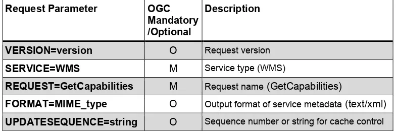
6.6.1. GetCapabilities Operation Request
The purpose of the mandatory GetCapabilities operation is to obtain service metadata, which is a machine readable (and human-readable) description of the server’s information content and acceptable request parameter values. Table 3 lists the GetCapabilities request parameters.
Request Parameter OGC Mandatory /Optional
Description
VERSION=version O Request version
SERVICE=WMS M Service type (WMS)
REQUEST=GetCapabilities M Request name (GetCapabilities)
FORMAT=MIME_type O Output format of service metadata (text/xml)
UPDATESEQUENCE=string O Sequence number or string for cache control
Table 3: The parameters of a GetCapabilities request URL as per Normative Reference [1]
Requirement 8: A DGIWG WMS server shall support all GetCapabilities request parameters.
6.6.2. GetCapabilities Operation Response
When invoked on a WMS, the response to a GetCapabilities request shall be an XML document containing service metadata formatted according to the XML Schema in annex E.1 of the OGC WMS 1.3 standard Normative Reference [1].
6.6.2.1.
Names and titles
A number of elements have both a <Name> and a <Title>. The Name is a text string used for machine-to-machine communication while the Title is for the benefit of humans.
6.6.2.2.
General service metadata
The first part of the service metadata is a <Service> element providing general metadata for the server as a whole. It shall include a Name, Title, and Online Resource URL. Optional service metadata includes Abstract, Keyword List, Contact Information, Fees, Access Constraints, and limits the number of layers in a request or the output size of maps.
Requirement 9: A DGIWG WMS server shall provide all mandatory and optional service metadata elements.
The elements <Fees> and <AccessConstraints> may be omitted in an OGC WMS if they do not apply to the server. If either of those elements is present, the reserved word "none" (case-insensitive) shall be used if there are no fees or access constraints, as follows: <Fees>none</Fees>, <AccessConstraints>none</AccessConstraints>.
In a DGIWG WMS server the AccessConstraints element shall always be used. In an NATO environment, the common NATO classification scheme has to be applied (see Normative Reference [3] DMF chapter 5.6.1.4 Classification Level Codelist).
Requirement 10: A DGIWG WMS server shall identify the highest classification level of the content accessible through the WMS service by populating the wms:AccessConstraints element.
6.6.2.3.
Capability metadata
The <Capability> element of the service metadata names the actual operations that are supported by the server, the output formats offered for those operations, and the URL prefix for each operation. The XML schema includes placeholders for Distributed Computing Platforms other than HTTP, but currently only the HTTP platform is defined.
W Layers and styles: Each available map is advertised by a <Layer> element in the service metadata. A server shall include at least one <Layer> element for each map layer offered.
W Layer properties: The <Layer> element can enclose child elements providing
metadata about the Layer. The values of some of these elements can be inherited by subsidiary layers. The following metadata elements are available:
o Title: A <Title> is mandatory for all layers; it is a human-readable string for presentation in a menu. The Title is not inherited by child Layers.
o Name: If, and only if, a layer has a <Name>, then it is a map layer that can be requested by using that Name in the LAYERS parameter of a GetMap request. If the layer has a Title but no Name, then that layer is only a category title for all the layers nested within. A containing category itself may include a Name by which a map portraying all of the nested layers can be requested at once. For example, a parent layer "Roads" may have children “Interstates” and “State Highways” and allow the user to request either child individually or both together. o The elements <Abstract> and <KeywordList> are optional in the base
Requirement 11: A DGIWG WMS server shall include the following information in the abstract element of the service metadata: "This service implements the DGIWG WMS 1.3 profile version 1.0."
Requirement 12: A DGIWG WMS server shall provide a minimum keyword list based on the DFDD groups:
Aeronautical Biota
Characteristics Demarcation
Hydrography and Oceanography Industries and Services
Metadata and References Military
Names and Designations Physiography
Socio-economic Geography Transportation
Weather and Climate
NOTE: Additional keywords may be added to the list as appropriate to support data discovery.
o Zero or more Styles may be advertised for a Layer or collection of layers using <Style> elements, each of which shall have <Name> and <Title> elements.
§ The style's Name is used in the Map request STYLES parameter.
§ The Title is a human-readable string. If only a single style is available, that style is known as the “default” style and need not be advertised by the server.
Requirement 13: A DGIWG WMS server shall provide information on the supported styles.
Requirement 14: A DGIWG WMS server shall always provide at least one style element and that style shall be advertised even if it's only the default style.
Requirement 15: The MaxWidth and MaxHeight shall be greater or equal to 800 pixels.
o <LegendURL> contains the location of an image of a map legend appropriate to the enclosing style.
Requirement 16: Each vector data layer's style shall have an associated legend, available as an image in one of the following formats: PNG, GIF or JPEG.
Recommendation 2: It is recommended to also provide legends for raster layers representing numeric data like for instance elevation or temperature data
Requirement 17: This legend shall be accessible online at the URL specified by LegendURL.
o Scale denominators: The <MinScaleDenominator> and
Requirement 18: A DGIWG WMS server shall provide scale denominators for all layers it provides.
Requirement 19: The <MinScaleDenominator> value shall always be less than or equal to the <MaxScaleDenominator> value.
Recommendation 3: A DGIWG WMS service should be configured to serve requests that range from at least 4x to at least 0.25x the native scale(s) or resolution(s) of the underlying datasets".
NOTE: Users should be aware that changing the resolution at a range of 4 times to 0.25 times effects the accuracy of the displayed data significantly and will influence the usability of the data for certain use cases (e.g. measurements in the map).
o Sample dimensions: Some geographic information may be available at other dimensions (for example, satellite images in different wavelength bands). The dimensions other than the four space-time dimensions are referred to as “sample dimensions. A DGIWG WMS server may allow for requesting a particular layer along one or more dimensional axes other than time or elevation.
o MetadataURL: A server should use one or more <MetadataURL> elements to offer detailed, standardized metadata about the data corresponding to a
particular layer. The “type” attribute indicates the standard to which the metadata complies. Two “type” attribute values are defined in ISO 19128:2005, "ISO 19115:2003" and “FGDC:1998”. The enclosed <Format> element indicates the file format MIME type of the metadata record.
Recommendation 4: In an SDI like architecture, a DGIWG WMS server should provide a link to the metadata resource via a resolvable URL for example to a CSW server.
o FeatureListURL: A server may use a <FeatureListURL> element to point to a list of the features represented in a Layer. The enclosed Format element indicates the file format MIME type of the feature list.
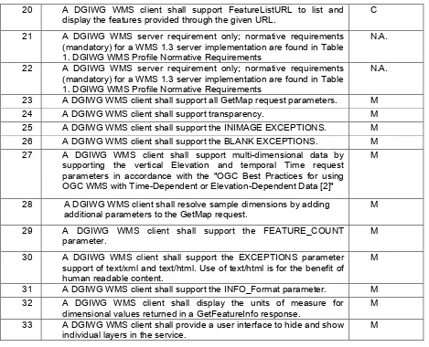
Requirement 20: If the GetCapabilities document identifies support for FeatureListURL then the list of features that are in the particular layer shall be resolvable through the provided URL.
o DataURL: A server may use DataURL to offer a link to the underlying data represented by a particular layer. The enclosed Format element indicates the file format MIME type of the data file.
Requirement 21: If the GetCapabilities document identifies support for DataURL then the underlying data of the particular layer shall be resolvable through the provided URL.
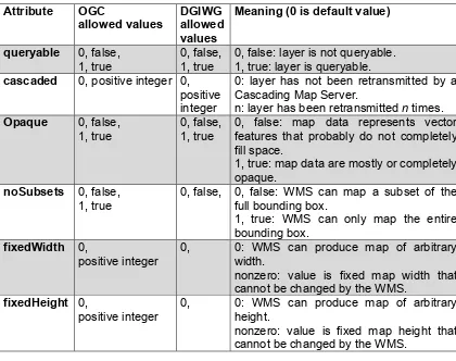
Attribute OGC
0, false: layer is not queryable. 1, true: layer is queryable. cascaded 0, positive integer 0,
positive integer
0: layer has not been retransmitted by a Cascading Map Server.
0, false: map data represents vector features that probably do not completely fill space.
1, true: map data are mostly or completely opaque.
noSubsets 0, false, 1, true
0, false, 0, false: WMS can map a subset of the full bounding box.
1, true: WMS can only map the entire bounding box.
fixedWidth 0,
positive integer
0, 0: WMS can produce map of arbitrary width.
nonzero: value is fixed map width that cannot be changed by the WMS.
fixedHeight 0,
positive integer
0, 0: WMS can produce map of arbitrary height.
nonzero: value is fixed map height that cannot be changed by the WMS.
Table 4: Layer attributes
Requirement 22: A DGIWG WMS server shall provide the Layer Attributes according to Table 4.
Recommendation 5: A DGIWG WMS server offering vector layers should be queryable The Layer metadata may also include three optional attributes that indicate a map server that is less functional than a normal WMS, because it is not able to extract a subset of a larger dataset or because it only serves maps of a fixed size and cannot resize them.
When set to a true value, noSubsets indicates that the server is not able to make a map of a geographic area other than the layer's bounding box.
6.6.3. GetMap Operation Request
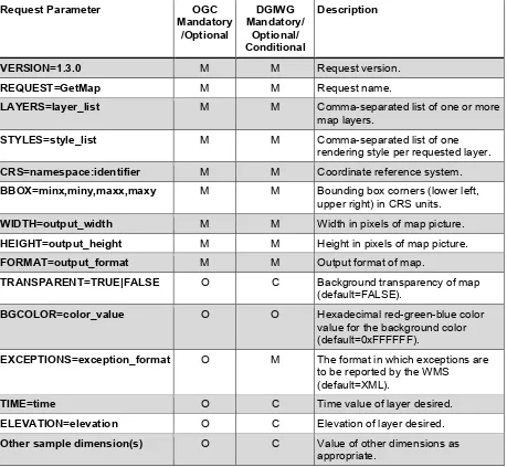
The GetMap operation returns a map. Upon receiving a GetMap request, a WMS shall either satisfy the request or issue a service exception. Table 5 lists the parameters of a GetMap request.
Request Parameter OGC
Mandatory /Optional
DGIWG Mandatory/
Optional/ Conditional
Description
VERSION=1.3.0 M M Request version.
REQUEST=GetMap M M Request name.
LAYERS=layer_list M M Comma-separated list of one or more
map layers.
STYLES=style_list M M Comma-separated list of one
rendering style per requested layer.
CRS=namespace:identifier M M Coordinate reference system.
BBOX=minx,miny,maxx,maxy M M Bounding box corners (lower left, upper right) in CRS units.
WIDTH=output_width M M Width in pixels of map picture.
HEIGHT=output_height M M Height in pixels of map picture.
FORMAT=output_format M M Output format of map.
TRANSPARENT=TRUE|FALSE O C Background transparency of map (default=FALSE).
BGCOLOR=color_value O O Hexadecimal red-green-blue color value for the background color (default=0xFFFFFF).
EXCEPTIONS=exception_format O M The format in which exceptions are to be reported by the WMS
(default=XML).
TIME=time O C Time value of layer desired.
ELEVATION=elevation O C Elevation of layer desired.
Other sample dimension(s) O C Value of other dimensions as appropriate.
Requirement 23: A DGIWG WMS server shall support all GetMap request parameters.
W Styles: The mandatory STYLES parameter lists the style in which each layer is to be rendered.
W Width, Height: The mandatory WIDTH and HEIGHT parameters specify the size in integer pixels of the map to be produced.
W TRANSPARENT: The optional TRANSPARENT parameter specifies whether the map background is to be made transparent or not. TRANSPARENT can take on two values, "TRUE" or "FALSE". The default value is FALSE if this parameter is absent from the request.
Requirement 24: A DGIWG WMS Service shall support transparency
W EXCEPTIONS: The optional EXCEPTIONS parameter defines the format of an error message. XML is mandatory and the default format for exceptions.
o INIMAGE: If the EXCEPTIONS parameter is set to INIMAGE, the WMS shall, upon detecting an error, return an object of the MIME type specified in the FORMAT parameter whose content includes text describing the nature of the error. In the case of a picture format, the error message shall be drawn on the returned picture. In the case of a graphic element format, the text of the error message shall be rendered in the manner that text is normally represented in that format.
Requirement 25: A DGIWG WMS server shall support the INIMAGE EXCEPTIONS.
o BLANK: If the EXCEPTIONS parameter is set to BLANK, the WMS shall, upon detecting an error, return an object of the type specified in FORMAT whose content is uniformly “off”. In the case of a picture format, that response shall be an image containing only pixels of one color (the background color). In the case of a picture format supporting transparency, if TRANSPARENT=TRUE is specified the pixels shall all be transparent. In the case of a graphic element output format, no visible graphic elements shall be included in the response output.
Requirement 26: A DGIWG WMS server shall support the BLANK EXCEPTIONS.
W Time, Elevation, Other sample dimensions: An example would be the request for a single ozone map at specified time and height:
Example
http://ageobwserver.org/...?VERSION=1.3.0&REQUEST=GetMap&CRS=CRS:84&BBOX =-180,-90,180,90&WIDTH=600&HEIGHT=300&LAYERS=
Requirement 27: If a DGIWG WMS server provides multi-dimensional data then it shall:
W Support the vertical Elevation and temporal Time request parameters.
W Handle data utilized in these parameters in accordance with the "OGC Best Practices for using OGC WMS with Time-Dependent or Elevation-Dependent Data [2]"
NOTE: Conformant WMS servers should express the values of the time dimension either as one time interval with non-zero resolution when the temporal dependency of the data is time instants or as a comma separated list of timestamps.
The WMS 1.3 specification allows the possibility to define multiple times as several triplets: start/end/interval. The triplets define sets of time instants that may overlap. It is difficult for a human reader to determine the allowed times of the time dimension. Hence, the time dimension should not be specified as a list of triplets, except if the time instants are regularly spaced with a unique interval of time. If not the time instance should be specified as a comma separated list.
Requirement 28: A DGIWG WMS server that announces available sample dimensions in its service metadata shall resolve the corresponding parameters provided in the GetMap operation for requesting these dimensional values.
Example
A WMS Layer is described as having an extent along a dimension named “wavelength” as follows:
<Dimension name="wavelength" units="Angstrom"
unitSymbol="Ao">3000,4000,5000,6000<Dimension>.A GetMap request for a portrayal of the data at 4000 Angstroms would include the parameter “DIM_WAVELENGTH=4000”."
6.6.4. GetMap Response
The response to a valid GetMap request shall be a map of the spatially referenced information layer requested, in the desired style, and having the specified coordinate reference system, bounding box, size, format and transparency.
6.6.5. GetFeatureInfo Operation Request
GetFeatureInfo is an optional operation. It is only supported for those Layers for which the attribute queryable="1" (true) has been defined or inherited. A client shall not issue a GetFeatureInfo request for other layers. A WMS shall respond with a properly formatted service exception (XML) response (code = OperationNotSupported) if it receives a GetFeatureInfo request but does not support it.
WIDTH, HEIGHT) in that GetMap request, along with the I,J position the user chose, the WMS can (possibly) return additional information about that position.
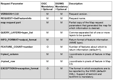
The parameters of a GetFeatureInfo request are listed in Table 6.
Request Parameter OGC
Mandatory / Optional
DGIWG Mandatory / Optional
Description
VERSION=1.3.0 M M Request version.
REQUEST=GetFeatureInfo M M Request name.
map request part M M Partial copy of the Map request parameters that generated the map for which information is desired.
QUERY_LAYERS=layer_list M M Comma-separated list of one or more layers to be queried.
INFO_FORMAT=output_format M M Return format of feature information (MIME type).
FEATURE_COUNT=number O M Number of features about which to return information (default=1).
I=pixel_column M M i coordinate in pixels of feature in Map CS.
J=pixel_row M M j coordinate in pixels of feature in Map CS.
EXCEPTIONS=exception_format O M The format in which exceptions are to be reported by the WMS (default= XML). Support of text/xml and text/html is mandatory.
Table 6: GetFeatureInfo Request parameters
6.6.5.1.
Version
The VERSION parameter is mandatory. The value “1.3.0” shall be used for GetFeatureInfo requests that comply with ISO 19128:2005.
6.6.5.2.
Request
The REQUEST parameter is mandatory. For GetFeatureInfo, the value “GetFeatureInfo” shall be used.
6.6.5.3.
Map request part
The mandatory “map request part” represents a sequence of parameters from the GetMap request that generated the original map. Two of the GetMap parameters are omitted because GetFeatureInfo provides its own values: VERSION and REQUEST. The remainder of the GetMap request shall be embedded contiguously in the GetFeatureInfo request.
6.6.5.4.
Query_Layers
6.6.5.5.
INFO_FORMAT
The mandatory INFO_FORMAT parameter indicates what format to use when returning the feature information.
6.6.5.6.
Feature_COUNT
The optional FEATURE_COUNT parameter states the maximum number of features per layer for which feature information shall be returned. Its value is a positive integer. The default value is 1 if this parameter is omitted or is other than a positive integer.
Requirement 29: A DGIWG WMS server shall support the FEATURE_COUNT parameter to enable the increase of the number of features per layer for which the server returns information.
NOTE: Using a high value for the Feature_COUNT parameter may affect server performance. A server might restrict the number of features for which information is retrievable. This limitation has to be advertised in the capabilities document.
6.6.5.7.
I, J
The mandatory I and J request parameters are integers that indicate a point of interest on the map that was produced by the embedded GetMap request (the “map request part” described in 7.4.3.3). The point (I,J) is a point in the (i,j) space defined by the Map CS (see 6.7.2). Therefore:
W the value of I shall be between 0 and the maximum value of the i axis; W the value of J shall be between 0 and the maximum value of the j axis; W the point I=0, J=0 indicates the pixel at the upper left corner of the map; W I increases to the right and J increases downward.
The point (I,J) represents the centre of the indicated pixel.
If the value of I or of J is invalid, the server shall issue a service exception (code = InvalidPoint).
6.6.5.8.
EXCEPTIONS
The EXCEPTIONS parameter is optional. If this parameter is absent from the request, the default value is "XML". No other values are defined by ISO 19128:2005 for the WMS GetFeatureInfo request. Use of text/html is for the benefit of human readable content.
Requirement 30: A DGIWG WMS server shall support the EXCEPTIONS parameter support of text/xml and text/html.
6.6.6. GetFeatureInfo response
The server shall return a response according to the requested INFO_FORMAT if the request is valid, or issue a service exception otherwise. The nature of the response is at the discretion of the service provider, but it shall pertain to the feature(s) nearest to (I,J).
Requirement 31: A DGIWG WMS server shall provide a response according to the INFO_Format.
7. Quality of Service
Quality of service comprises requirements on all the aspects of a connection. A DGIWG WMS server should meet the following guidelines for performance, availability and capacity.
7.1. Performance
Recommendation 6: For a 470 Kilobytes image, the response time for sending the initial response to a Get Map Request to a view service shall be maximum 5 seconds in normal situation.
NOTE: Normal situation represents periods out of peak load. It is set at 90% of the time.
7.2. Capacity
Recommendation 7: The number of simultaneous service requests that a DGIWG WMS server should be able to support is at least 20 per second.
7.3. Availability
Recommendation 8: A DGIWG WMS server should be available 99.9% of the time.
Annex A – Abstract Test Suite
(normative)
A.1
DGIWG Service Type
A.1.1
DGIWG Service Type
a) Test Purpose: Verify that a DGIWG WMS server satisfies all requirements for a OGC Queryable WMS conformance class (DGIWG Requirement 1)
b) Test Method: Submit a GetFeatureInfo requests to the server and verify that it is providing a proper response.
c) References: Clauses 6.4 d) Test Type: Capability
A.1.2
DGIWG WMS Binding
a) Test Purpose: Verify that a DGIWG WMS server supports HTTP Get requests (DGIWG Requirement 2).
b) Test Methods:
1. Submit HTTP Get GetCapabilities request and verify that the server is providing a proper response.
2. Submit HTTP Get GetMap request and verify that the server is providing a proper response.
c) References: Clauses 6.5.2 d) Test Type: Capability
A.1.3
DGIWG WMS Output format
a) Test Purpose: Verify that a DGIWG WMS server satisfies all the requirements for supported outputs (DGIWG Requirement 3, 4 and 5).
b) Test Method: Submit requests and verify that the server implements support for: 1. Submit a GetCapabilities request (FORMAT = text/xml) and verify that the
response is text/xml
2. Submit a GetCapabilities request (FORMAT = text/html) and verify that the response is text/html
3. Submit a GetFeatureInfo request (FORMAT = text/xml) and verify that the response is text/xml
4. Submit a GetFeatureInfo request (FORMAT = text/html) and verify that the response is text/html
5. A response to a "GetCapabilities" request in English language
6. Submit a GetMap request (FORMAT = image/png) and verify that the response is image/png
7. Submit a GetMap request (FORMAT = image/gif) and verify that the response is image/gif
c) References: Clauses 6.5.3 d) Test Type: Capability
A.1.4
DGIWG WMS CRS
a) Test Purpose: Verify that a DGIWG WMS server satisfies all the requirements for handling CRS’s (DGIWG Requirement 2).
b) Test Method:
1. Submit requests and verify that all supported CRS are advertised for all available data in the XML response (Capabilities document) to a valid GetCapabilities request.
2. Submit GetMap requests and verify that maps are provided in the mandatory CRSs and the appropriate projections for each validity zone.
c) References: Clauses 6.5.4 d) Test Type: Capability
A.1.5
DGIWG WMS Request Parameters - Exceptions
a) Test Purpose: Verify that a DGIWG WMS server satisfies all the requirements for the exceptions request parameter rule (DGIWG Requirement 7).
b) Test Method: Generate a sample of invalid requests from a client. Verify that the server provides an appropriate response in English.
c) References: Clauses 6.5.5.2 d) Test Type: Capability
A.2
DGIWG WMS Operations
A.2.1
DGIWG WMS GetCapabilities request
a) Test Purpose: Verify that a DGIWG WMS server satisfies all the requirements for a GetCapabilities operation request (DGIWG Requirement 8).
b) Test Method: Generate sufficient GetCapabilities requests from the client to verify that each parameter is supported.
c) References: Clauses 6.6.1 d) Test Type: Capability
A.2.2
DGIWG WMS GetCapabilites Response
a) Test Purpose: Verify that a DGIWG WMS server satisfies all the requirements for a GetCapabilities operation request (DGIWG Requirements 9 - 22).
b) Test Method:
2. Submit a GetCapabilities request and verify that the response uses <AccessContraints> to identify classification levels for the service.
3. Submit a GetCapabilities request and verify that the response in the Abstract element contains the following information: "This service implements the DGIWG WMS 1.3 profile version 1.0."
4. Submit a GetCapabilities request and verify that the response provides a keywordlist that is based on the DFDD groups.
5. Submit a GetCapabilities request and verify that the response provides information on the supported styles.
6. Submit a GetCapabilities request and verify that the response provides a defined style for the default style.
7. Submit a GetCapabilities request and verify that the values for MaxWidth and MaxHeight, when used, are greater than or equal to 800 pixels.
8. Submit a GetCapabilities request and verify that the response provides an associated legend in at least one of the following formats: PNG, GIF, JPEG. 9. Submit a GetCapabilities request and verify that the provided LegendURL is
accessible online.
10. Submit a GetCapabilities request and verify that the response provides scale denominators for all layers.
11. Submit a GetCapabilities request and verify that the provided <MinScaleDenominator> value is less than or equal to the <MaxScaleDenominator>.
12. Submit a GetCapabilities request and verify that for all provided FeatureListURLs the list of features is resolvable through the provided URL. 13. Submit a GetCapabilities request and verify that for all provided DatURLs the
data is resolvable through the provided URL.
14. Submit a GetCapabilities request and verify that all XML attributes are provided according to Table 4.
c) References: Clauses 6.6.2 d) Test Type: Capability
A.2.3
DGIWG WMS GetMap Request
a) Test Purpose: Verify that a basic WMS client satisfies all requirements for a GetMap request (DGIWG Requirements 23 - 28).
b) Test Method:
1. Submit a GetMap request and verify support for all GetMap request parameters according to Table 5.
2. Submit a GetMap request and verify support for transparency.
3. Submit a GetMap request and verify support for INIMAGE_EXCEPTIONS. 4. Submit a GetMap request and verify support for BLANK_EXCEPTIONS. 5. Submit a GetMap request and verify that for WMS that serve
multi-dimensional data support for ELEVATION and TIME parameters is provided. 6. Submit a GetMap request and verify that for WMS that serve
multi-dimensional data the data utilized is provided according to OGC MetOc “Best Practices for using OGC WMS with Time-Dependent or Elevation-Dependent Data”.
7. Submit a GetMap request and verify that for WMS servers that advertise sample dimensions resolve corresponding parameters correctly.
c) References: Clauses 6.6.3 d) Test Type: Capability
A.2.4
DGIWG GetFeatureInfo Operation Request -
FEATURE_COUNT
a) Test Purpose: Verify that a DGIWG WMS server satisfy all the requirements for the FEATURE_COUNT parameter (DGIWG Requirement 29).
b) Test Method: Submit a GetFeatureInfo request from the client and verify that the FEATURE_COUNT parameter can be used to increase the number of features per layer for which the server returns information.
c) References: Clauses 6.6.5.1 d) Test Type: Capability
A.2.5
DGIWG GetFeatureInfo Operation Request - EXCEPTIONS
a) Test Purpose: Verify that a DGIWG WMS server satisfies all the requirements for the EXCEPTIONS parameter (DGIWG Requirement 30).
b) Test Method: Submit a GetFeatureInfo request from the client and verify that the EXCEPTIONS parameter is used and supports both text/xml and text/html formats. c) References: Clauses 6.6.5.3
d) Test Type: Capability
A.2.6
DGIWG WMS GetFeatureInfo Response
a) Test Purpose: Verify that a DGIWG WMS interface satisfies all requirements for the operation
GetFeatureInfo
(DGIWG Requirement 31).b) Test Method: Submit a GetFeatureInfo request from the client and verify that an appropriate response is returned according to the requested INFO_Format.
Annex B – Use cases
(informative)
Type Title Use Case Description Relevance
Discover Discover georeferenced information (GI) for task
The ability to locate GI available for exploitation within an
application. The Basic User can navigate lists of GI datasets to decide which are appropriate to his task.
The ability to retrieve a list of layers served by WMS through the use of a GetCapabilities request.
Discover Load GI into applications
The Basic User has identified GI and/or services of interest which have a geospatial context and wishes to use them within the application.
The ability to use WMS to load GI into applications or clients which support the OGC WMS specification.
Discover Unload GI from application
The Basic User wishes to unload data or services from application
The ability to remove
connections to WMS services or hide visibility of layers using clients which support the OGC WMS specification
Create Populate Metadata
The Advanced User populates pre-defined metadata fields.
The ability to add descriptive information about a data service and layer in the <Abstract> Create Link
textual/audio/vis ual data to GeoINT
The Advanced User links textual / audio / visual data to GI.
The ability to incorporate URL links to other documents and resources within WMS attributes.
Create Create Custom Symbology (S)
The Advanced User
creates/edits custom symbology and saves it.
The ability to define how layers should be symbolised within a WMS map service, including thematic ranges.
Analysis Identify Query GI at a
pixel/feature/obj ect on the display
The Basic User queries information about GI for a pixel/feature/object on the display.
The ability to perform a GetFeatureInfo request to retrieve information about a feature at a specific location.
Analysis Select
features/objects based on spatial extent
The Basic User selects features/objects based on a spatial extent in a graphical display.
The ability to display map features following the submission of a request containing a bounding box map extent.
Analysis Select GI based on temporal data
The Basic User selects GI based on temporal data.
The ability to submit a GetMap request incorporating a time parameter to retrieve data for a specific point in time
Analysis Select Raster or Grid Cells
The Advanced User selects raster or grid cells based on cell or cell values
The ability to query raster data values in WMS layers and display them thematically based on their value
Display View 2D and/or 3D GI
The Basic User views 2D and/or 3D GI (including GeoINF (base mapping), GeoINT and other geo-referenced information) rendered in an appropriate manner vector and/or raster in a single coherent view.
Type Title Use Case Description Relevance Display View the quality,
accuracy or confidence level of the GI
The Basic User views the quality, accuracy or confidence level of the GI.
The ability to view additional information about the accuracy of a layer as part of its metadata
Display Set the scale threshold at which data shall be displayed (for user created data)
The Advanced User sets the scale threshold at which user created data shall be displayed.
The ability to define zoom scale thresholds for the appearance of layers
Display Display Legend The Basic User views a display legend and the corresponding real-world objects.
The ability to view a legend containing representations of each layer’s symbology Display Projections and
Datums Views
The Basic User views GI displayed using a pre-defined operational datum and views GeoINF in the approved projection for the area and the data provided.
The ability to display data in defined projections
Display Projections and Datums
Changes (S)
The Advanced User changes the projection of the display or the datum to another approved projection/datum.
The ability to modify projections used to display data
Display View Temporal sequences of environmental events
The Basic User views temporal sequences of environmental events.
The ability to submit a GetMap request incorporating a time parameter to retrieve data for a specific point in time
Display Layer Display and
Management
The Basic User performs layer display and management functions
The ability to define layer ordering within a map service and define which layers to request for display. Display View GI Labels The Basic User views the GI
labels and turns off the label display.
The ability to present labels as layers within the WMS
Display View GI Attributes
The Basic User view the attributes or metadata of the GI.
The ability to query a feature within a WMS layer to retrieve associated information or view related metadata
The Advanced User shares user created GI to LAN or WAN or other users cross domain.
The ability to share access to data through WMS services.
Share or Export
Publish to Web Service
The Advanced User can publish to a Web Service to support the sharing of GI to other users and applications.
The ability to publish data via WMS services.
Share or Export
Unpublish from a Web Service
The Advanced User can
unpublish GI from a web service which has been previously been published.