The Development of Image-based Algorithm to
Identify Altitude Change of a Quadcopter
Nemuel Daniel Pah, Henry Hermawan
Electrical EngineeringUniversity of Surabaya Surabaya, Indonesia [email protected]
Abstract—Quadcopter, a popular Unmanned Aerial Vehicle (UAV), is able to land, take off, hover, and move on 3D trajectory. The ability requires accurate control of the rotors velocity based on input from its sensors. One of the control mechanisms is the altitude control. This paper presents a new algorithm to identify altitude change of a quadcopter based on image processing techniques. The algorithm is designed to be simple and efficient in terms of computation and memory usage. The algorithm identifies altitude change by calculating correlation function of 10 sampled rows of pixels. This paper also presents some experiments conducted to investigate the performance of the algorithm. The results indicated that the algorithm is able to properly identify altitude change with accuracy of more than 96%.
Keywords—Quadcopter; quadrotor; altitude control; image-based distance measurement
I. INTRODUCTION
The research and development of Unmanned Aerial Vehicles (UAV) has become an interesting field since the 1990s [1]. The development was initially driven by military applications. In the recent years, small UAV has been developed for public applications such as traffic observations, rescue missions, environmental observations, photography, and other hobby related activities.
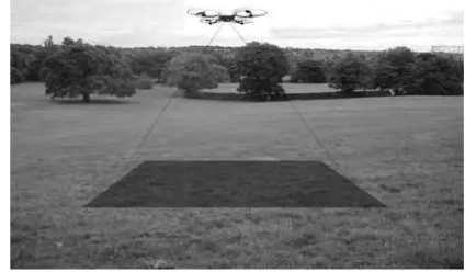
Quadcopter, a type of small UAV, has become popular among public users due to its size, price, and controllability [2]. Quadcopter is a four rotors helicopter as shown in Fig. 1. The rotors are directing upwards and arranged in a square formation. The movement of quadcopter is controlled by the angular velocity of the rotors. By properly controlling the velocity of each rotor, a quadcopter can move along a specific 3D trajectory and hover steadily. The accuracy of such movements is depending on its control systems and the accuracy of information from its sensors [3].
One of the important control mechanisms is the altitude control. Various control methods have been used, such as PID controllers [4-6] and fuzzy controllers [7-10]. These controllers need accurate altitude information from sensors. Some of the commonly used sensors are accelerometer, barometer, GPS, sonar, and laser sensor [2], [5], [11]. Camera, mounted on most quadcopters, can also be used as a sensor to provide position-related information, including altitude.
Fig. 1. Illustration of quadcopter with facing down camera.
This research is conducted to develop image-based algorithm that is able to sense altitude change. The algorithm is commonly known as image-based distance measurements system. Image–based distance measurement can be classified into three approaches. The parallax approaches [12-14] determine object distance by computing variance of position in two images captured by two cameras or combination of mirrors. The approach requires complex computation and a stereo camera arrangement. This approach is not suitable for a small quadcopter. The second approach measures object distance with an aid of some markers. Barreto [15] and Muljowidodo [16] based their algorithm on triangulation of a single laser beam, while Deng [12] and Lu [17] used two parallel laser beam projected to the object. The other approach is based on a priori knowledge of object physical size [19]. Such a requirement is not easily implemented in quadcopter. Quadcopters are designed to fly above different fields with various objects in different sizes.
This paper reports the development of an efficient image-based algorithm to identify the change of distance between camera and the captured object. The algorithm is designed to work on a single camera without the aid of image marker such as laser beam. The algorithm is to be applied in quadcopter as a sensor to provide information about altitude change to its controller. The current development reported in this paper shows a promising result. The algorithm can identify altitude change with a successful rate above 76% and altitude change accuracy of more than 96%.
This paper is organized into four sections. Section II introduces the algorithm with detailed explanation on each 2015 7th International Conference on Information Technology and Electrical Engineering (ICITEE), Chiang Mai, Thailand