T
HE FORTUNES OF
THE TLATEPUZCAN CHINANTECS
OF SAN JUAN PALANTLA
1928–2005
William R. Merrifield
SIL International
SIL e-Books 15
©2009 SIL International ISBN: 978-1-55671-242-5
ISSN: 1934-2470
Fair Use Policy
Books published in the SIL e-Books (SILEB) series are intended for scholarly research and educational use. You may make copies of these publications for research or instructional purposes free of charge (within fair use guidelines) and without further permission. Republication or commercial use of SILEB or the documents contained therein is expressly prohibited without the written consent of the copyright holder(s).
Series Editor George Huttar
Volume Editor Doris Blood
FOREWORD
It is my high privilege to introduce this book authored by Bill Merrifield. My wife Pat and I and our two small children first arrived in Palantla in December of 1965 to assist the Merrifields in the linguistic project they had started nine years previously. In perusing this book I have found many of the friends we have known over the years and also the neighborhoods so familiar to us from our fifteen years as residents of Palantla.
This volume is being published posthumously as an e-book since Bill passed away on March 24, 2008. He had other titles that he had not finished, including a detailed description of the Chinantec worldview and a collection of Chinantec texts.
Bill Merrifield was a passionate man and also one who possessed a variety of talents. His passion and the talents are displayed in the publication before us.
He loved his God, his wife, Grace, his children and grandchildren. After these priorities came his love for research and for people he met along the way. His love for research and for people drove Bill to produce the present volume.
The book is a chronicle of the Tlatepuzcan Chinantec people, recording details of marriages, births, deaths, and changing residence patterns at various stages of their lives. Bill exhibited a stupendous amount of patience and perseverance in assembling such minute detail. Reading the large body of information Bill put together is a dizzying experience. Sprinkled throughout the book are examples of Bill’s wry wit.
Along with the history of these people, Bill produced an orderly presentation of their material culture and the social, familial, and political organization, as well as a picture of how the Chinantecs lived their lives in this remote corner of the world. This history shows evidence of forces and events beyond their control and how they responded and are responding to their situation. “Insufficient Land” is not always explicit, but it is the undercurrent driving changing residence in Palantla history.
In addition to the countless hours of research that produced this volume, the presentation of charts and drawings and the many photographs of people and places give an expanded view of the subject matter— real people who were and are living in the real world in which they have found themselves.
I commend to you this work that I trust will enhance your view of our world and the human condition.
Alfred E. Anderson SIL International
Contents
Contents
Abstract
1 Insufficient Land Documentation Names
Ages Marriage
Personal Identification
2 The Founding of Palantla, 1501–1928 Who are the Chinantecs
The Otomangueans Internal Diversity
Palantla’s Early Roots Catastrophic events La Gran Chinantla Two Palantla locations The Languages
Four summary statements from Manuel Martínez Gracida San Juan Bautista Valle Nacional
Santa María de la Asunción Jacatepec San Pedro Tlatepuzco
Santa Cruz Tepetotutla Onset of the Twentieth Century
Pre-1930s Palantla The Justo Families
The Apolinar Justo Family The José María Justo Family The José Villar Vicente Family Summary
The Move from San Pedro Tlatepuzco to Palantla
3 Repopulating Palantla, 1928–1935 1930s Westbrook
The Pedro José Family The Bernardo Juan Family The Martínez families
The Norberto and Sixto Martínez Families 1930s Uptown
The Andrés Martínez Family The Pedro Juan Domínguez Family The Norberto Martínez Family
The Sabino Martínez Ramírez Family The Miguel Martínez Ramírez Family Interpreting Tlatepuzco Censuses The Julián Pérez Family
The Juan Próspero Family 1930s West Side
The Martín Manuel González Family The Isidro Mariano Family
The José Villar Family The Pedro Pablo Juan Family The José María Antonio Family The Juan Neponoceno José Family The Ignacio Hilario Family
The Isidro Hilario Antonio Family The Junior Felipe Manuel Family 1930s South End
The José Bonifacio Antonio Family The Justo Domínguez Family The Francisco Eufracio Family The Pablo Ventura Family The Lucas Esteban Family 1930s East Side
The Bernardo Juan Family The Manuel de la Cruz Family The Pedro José Family
The Apolonio Bartolo Family The North End 1935
The Apolinar Justo Family
The Pedro de la Cruz Rivera Family The Senior Felipe Manuel Family The José María Justo Family Summing Up
4 The First Twenty-Five Years, 1931–1957 Westbrook in 1957
The Isidro José Juan Family The Francisco Juan Family
The Sixto Martínez Ramírez Family Uptown 1957
The Martínez families The Andrés Martínez Family
The Agustín Martínez Ramírez Family The Ricardo Martínez Family
The Julián Pérez Family The Agustín García Family The Felipe Próspero Family
The Pedro Juan Domínguez Family The Roberto Manuel González Family The Juan Crisanto Valdez Family The West Side in 1957
The Martín Manuel González Family The Isidro Mariano Family
The Rafael Justo Villar Family The José Villar Vicente Family The Pedro Pablo Juan Family
The Joaquín Antonio Rodríguez Family The Juan José Neponoceno Family The José Isidro Antonio Family The Máximo Hilario Carlos Family The Isidro Hilario Family
The South End in 1957
The Agustín Antonio Manuel Family The Justo Domínguez Family
The Francisco Eufracio Family The Mateo Ventura Manuel Family The Lucas Esteban Family
The East Side in 1957
The Ignacio Juan de la Cruz Family The Juan de la Cruz Family
The Pedro José Family
The Apolonio Antonio Family The Miguel José Domínguez Family The Hipólito Justo Family
The Apolonio Bartolo Family Healers
Death by Witchery The North End in 1957
The Ignacio Martínez Navarro Family The Prisciliano Gregorio Family The Simón Crisanto Family
The Pedro de la Cruz Rivera Family The Juan Crisanto Manuel Family The William Merrifield Family Summing Up
5 Palantla Social Organization
Palantla Chinantec Kinship Terminology Relative Age
Marriage The Kindred Ritual Kinship
Voluntary Associations
6 Palantla Political Organization Oaxacan Political Units Citizenship
Office
Election and Installation The Town Meeting Elections
Town work The Army The Ejido
The School Summary
7 Religion and Beliefs The Catholic Church Patrons
Songs and Prayers Candles
Festivals All Saints’ Day Holy Week Christmas Baptism Death
The Afterlife
Church Government Church Funds
A New Church House The Palantla Aerodrome
Rural development and the entrance of Evangelical Christianity
8 Everyday Life 222 Collecting 223 Fowling
224 Hunting and Trapping 226 Fishing
231 Domesticated Animals 241 Tillage
252 Food Preparation 264 Eating
285 Mats and Basketry 286 Woven Fabrics 294 Clothing Manufacture
296 Garment Cleaning and Repair 302 Toilet
303 Manufacture of Toilet Accessories 313 Lumbering
314 Forest Products 323 Ceramic Industries 324 Stone Industry
342 House Construction and Maintenance 422 and 423 Ownership
443 Retail Marketing
702 Military Recruitment and Training 744 Public Health and Sanitation 754 Witchcraft
757 Medical Therapy
787 Revelation and Divination 788 Ritual
796 Organized Ceremonial 827 Ethnopsychology 844 Childbirth
9 The Second Twenty-Five Years, 1957–1982 The Straw that Broke the Camel’s Back
Villanueva (first location) Villanueva Segundo Plan Perico
Other Locations
Palantla Regenerates in the Face of Mass Emigration Westbrook in 1982
The Isidro José Family
The Sixto Martínez Ramírez Family The Hilario Hernández Martínez Family The Francisco Juan de la Cruz Family Uptown
The Miguel Martínez Ramírez Family The José Cruz Martínez Velasco Family The Isidro José Juan Family.
The Julián Pérez Family The Andrés Martínez Family
The Ignacio Martínez Navarro Family The Ramón Martínez Hernández Family The Ricardo Martínez Family
An Archaeological Diversion
The José Manuel Hernández Family The José Concepción de la Cruz Family The West Side in 1982
The Martín Manuel González Family The José Villar Family
The Mateo Ventura Manuel Family The Joaquín Antonio Rodríguez Family The Juan Neponoceno Family
The José Isidro Antonio Family The Isidro Martínez Antonio Family The Teodoro de la Cruz Justo Family The Juan Antonio Antonio Family The Francisco Manuel de la Cruz Family The South End in 1982
The Julián Mendoza Sevilla Family The Agustín Antonio Manuel Family The Roberto José Cabrera Family The Félix Esteban Ramírez Family The Bartolomé Martínez Acevedo Family The East Side
The Ignacio Juan de la Cruz Family The Pedro José Cabrera Family The Agapito Vidal Salinas Family The Faustino Antonio Morales Family The Joaquín Justo Family
The Antonio José Montoya Family The Hipólito Justo Family
The Apolonio Bartolo Family The North End
The Ignacio Martínez Navarro Family The Prisciliano Gregorio Family
The Simón Crisanto Family The Fortino Justo Roque Family
The Martín Martínez Family The Juan Crisanto Manuel Family The Alfred Anderson Family Marriages
The Family
10 The Third Twenty-Five Years, 1982–2005 Northbrook Creek
Housing and Industry The 1991 Exodus
Westbrook in 2005
The Isidro José Juan Family The Mushroom Industry
The Francisco Juan de la Cruz family Uptown in 2005
The Bonifacio José Martínez Family The Miguel Martínez Ramírez Family The Agustín Domínguez Terán Family The Jerónimo Martínez Antonio Family The José Manuel Hernández Family The José Concepción de la Cruz Family The Anastacio Pérez Hernández Family Satellite Telephone Communications
The Andrés Martínez Family
The Ignacio Martínez Navarro Family The Ramón Martínez Hernández Family The Ricardo Martínez Family
The Teresa Martínez Domínguez Family The Miguel Juan Martínez Family The Roberto Manuel González Family The West Side in 2005
The Francisco Martínez Miguel Family The Agapito Manuel García Family The Joel de Jesús Manuel Family The Juana Martínez Peralta Family The Joaquín Antonio Rodríguez Family The Hilario Hernández Martínez Family The Domingo Antonio Simeón Family The Gumercindo José Rivera Family The Isidro Martínez Antonio Family The Mario José Martínez Family The Theodoro de la Cruz Justo Family The Juan Antonio Antonio Family The Marcelino Manuel García Family The South End in 2005
The Reynaldo Fermín Pérez Family The Justo Domínguez Family
The Ricardo Arteaga Mendoza Family The Alberto Martínez Hernández Family The Bulmaro Domínguez Martínez Family The Julián Mendoza Sevilla Family
The Lorenzo Esteban Ventura Family The Bartolomé Martínez Acevedo Family The East Side in 2005
The José–Antonio Families
The Antonio–Manuel/Cardel Families The Faustino Antonio Morales Family The Alfredo Antonio Sixto Family The Eudoxio de Jesús Manuel Family The Tomás Sixto Antonio Family The Valentín Juan Martínez Family The Justo–Antonio Families
The Agapito Vidal Salinas Family New Middle School Buildings Eucario Antonio Martínez The North End in 2006
The Gregorio–Martínez Family Departs
Return of the Apolinar Justo Family to the North End The Fortino Justo Roque Family
The Ignacio Martínez Navarro Family The Martín Martínez Family
The Juan Crisanto Manuel Family Newcomers to the North End
The Ignacio Rivera Antonio Family The Jaime Rivera González Family The Juan Hernández Osorio Family The Cirilo Martínez Hilario Family The José Mendoza Juan Family
The Jerónimo Martínez Antonio family The Bulmaro Moreno Manzano Family The Silverio Manuel García Family The Pascasio Antonio Ramos Family The Pedro Hernández Martínez Family A Final Summing Up
Abstract
MAP OF MEXICO WITH LINKS:
Chapter 1
Insufficient Land
This study intimately reviews the lives and culture of Tlatepuzcan Chinantecs who re-established the small village of San Juan Palantla in northeast Oaxaca State in Southern Mexico in 1928.1 The study follows their journey from their ancient home in San Pedro Tlatepuzco to Palantla, over a period of eighty-five years, from 1920 to 2005. But before attending to a few technical matters relating to documentation of the underlying research, I wish to remark on a recurring theme that emerges throughout this period of Palantla history, that of Insufficient Land.
This theme undoubtedly also had relevance to Chinantecs of earlier periods as well.
One simple statement comes to mind when I think of the Tlatepuzcan Chinantecs of the twentieth century, just two Chinantec words, a verb and a noun—tsa¹jøg² huø¹ ‘there is insufficient land’. This phrase is more to the point than any attempt to interpret it. The noun huø¹, in this context, is simply ‘the land’; and the verb prefix tsa¹- negates the verb. But the verb root jøg² that I here render ‘is (not) sufficient’ really states that there is not enough room—not enough room to contain all the people and not enough room for all who occupy it to work and to provide an adequate living for themselves and their families.
An Illinois farmer might find Palantla land insufficient in other ways. It is located on the side of a limestone mountain. Bottom lands are negligible. The use of tractors and plows is out of the question. Slash it and burn it! Poke it with a stick and drop in seed! And if you do not do it in the same place too often, it yields quite well. No problem with rain, except for the fact that there may be too much. We will not go into the presence of mountain lions, vipers, and life-threatening disease. The primary problem, for a long, long time has been that the land is not as extensive as it needs to be.
Mesoamericans, from whom the Tlatepuzcan Chinantecs descend, have been small farmers for well over a thousand years. Their forebears first domesticated maize somewhere along the very mountain range that is still home to the Chinantecs today, perhaps as long ago as a Chinantec-speaking community even existed as such. I actually have a hunch, unverified by any scientific inquiry of my own, that prehistoric Otomangueans had probably already transitioned from an earlier semi-nomadic existence based on foraging to one of more settled horticulture before they divided into communities speaking distinct languages such as the one from which today’s Chinantec languages have descended. And while it is presumptuous to assume to know the thoughts of an entire people, I am inclined to believe that maize farming, along with that of associated crops, has provided a satisfactory economic foundation of life for this people and for their neighbors during most, if not all, of this long period.
The Tlatepuzcans I began to study in San Juan Palantla fifty years ago had a pretty tough life compared to the one I had personally experienced growing up in Midwestern United States. Communication with the Spanish-speaking community was absolutely minimal. Professional health services, as we know them, were utterly inferior. You know this last is true if you consider
1
that, with a few informal lessons in tropical medicine, I became (for awhile) something of a renowned purveyor of “modern medicine” to Palantla and its neighboring communities! Formal public education was pitiful (not meaning to be disrespectful of the few teachers who taught).
And yet, most of the people I met were generally well-fed and happy. Do I dare say,
contented? They displayed a healthy sense of humor. To be sure, the last of the century brought change and new opportunities, but economic life, if you will, was tolerable before that.
Resources were limited. People suffered and died when in other circumstances they might have found recovery and relief. A few inevitably drowned their sorrows in alcohol. I met a few who had decided that farming was not for them, and they left Palantla in search of ‘something better’. But the people were not generally in despair, except for one important factor that was a constant burden: There was not enough land for the children who were being born each year.
This is the essence of their story, over recent years, since I first became acquainted with the Tlatepuzcans. “If there is no more land here, we will somehow have to go look for it somewhere else.” This is what they have done and continue to do, because: Tsa¹jøg² huø¹.
This theme emerges over and over in the chapters that follow. The Tlatepuzcans of Palantla have found themselves in a terrible bind. On the one hand, they are trapped and bound by culture and heritage to the place of their birth and of their forebears. On the other hand, they find it necessary to travel elsewhere, to a place where there will be land sufficient to provide for their own families and for those of their posterity.
I will not further detail here what the following chapters document in this regard, except to excerpt one ancient record that evidences the existence of this challenge for Tlatepuzcans long before 1928. Through the kindness of Palantla friends I was able to examine and copy portions of an eighteenth-century record of land litigations between San Pedro Tlatepuzco, from whence recent Palantla immigrants have come, and its near neighbor, Santiago Tlatepuzco. This record, currently kept by officials of the small village of San Felipe de León, a former dependency of San Pedro, is a 103-page, 1908 compilation of litigation records from Mexico’s National Public Archive.
We learn from these records that Santiago and San Pedro, whose village centers lie perhaps seven or eight miles apart, along the San Pedro River, were once a single political unit, but with most political representation and power in the hands of the larger San Pedro group. The Santiago group then successfully separated politically from San Pedro in 1715, but without a clear demarcation of the land that had traditionally been theirs until 3 February, 1718. On that date, in court in the District town of Teutila of that era, a boundary line was established between them from a point along the San Pedro River where there then stood a certain large tree (palo de gobo) marked by a machete with a cross, the boundary leading to the south toward Santa Cruz Tepetotutla and to the north toward San Juan Palantla (which was at that time not occupied by Tlatepuzcans).
I here present in English translation just one short excerpt from those documents that comments on the land fights between San Pedro and Santiago of that day:
the unlawful quarrels that they were having at every step, and that each side would clearly mark the lands that were assigned them.
Many more examples could, of course, be brought forward of wars and disputes over land that have been one of the key factors in the diversification of Chinantecan, Otomanguean, and other populations in Mesoamerica throughout the last millennium. But I will let the rest of this volume tell its own story.
Documentation
This study is based primarily upon long-time residence in Palantla, under the auspices of the Summer Institute of Linguistics (now SIL International) and by contract with Mexico’s Secretary of Education. This time entailed language learning, participant observation, the collection and study of oral literature, formal inquiry with individual Chinantec language associates (known as “informants” in 1950s parlance), and numerous research visits to Palantla that postdate our years of residence in the community. My wife and I, she seven-months pregnant, emigrated to Mexico in December 1955, to take up residence among one of several Chinantec linguistic communities, to learn, analyze, and document their language; form an alphabet based on Spanish-language writing traditions and descriptive linguistic principles; provide reading instruction; and initiate the development of a published vernacular literature that would include translations of Christian scriptures.
Accordingly, two SIL colleagues (Cal Rensch and Frank Robbins) and I toured the Chinantec region on foot throughout most of the month of January 1956, looking for appropriate communities from which the Rensch and Merrifield families might undertake such language research and development. My choice for Grace and me became San Juan Palantla, which lay a three-hour brisk walk over a trail that rises 1500 feet above and to the WNW of Valle Nacional, Oaxaca. At the time, Valle Nacional was located 60-some kilometers south from Tuxtepec, Oaxaca, at the end of a dirt road that was still under construction and required two bridgeless river crossings and most of a day’s travel. Tuxtepec, Oaxaca, is around 600 kilometers from Mexico City by a circuitous route through the States of Puebla and Veracruz.
My first visit to Tuxtepec and Valle Nacional, however, was not by that route. Rather, on 5 January, I traveled by bus from Mexico City to the City of Oaxaca and Mitla, where I rendezvoused with Cal and Frank. The following day we went on to Juchitán, in the Isthmus of Tehuantepec, where we boarded a train for an eleven-hour ride to Villa Azueta, Veracruz, arriving on 7 January. From there we traveled three hours by truck and one hour on foot to Playa Vicente. From there, we walked seven and one-half hours into Oaxaca, crossing two rivers on vine suspension bridges, finally arriving in Chinantec territory on the ninth.
After our first daughter was born in Mexico City on 9 March, 1956, we gave support assistance to SIL in Mexico City while we became acclimated to Mexico and the SIL operation there, also assisting on staff at the SIL school at the University of Oklahoma during the summer. We finally moved to Palantla with our 8-month-old firstborn in late October, 1956. Our assignment for several years was to teach at SIL schools each summer and spend the rest of the time on our Chinantec project, until 1962, when a furlough period in the U.S. found us at Cornell University for graduate work in General Linguistics (M.A. 1963) and Cultural Anthropology (Ph.D. 1965).
After returning to Mexico in 1965, a greater part of my time was directed to teaching and consulting with other colleagues on their projects, with less time available for Chinantec research; and another couple, Al and Pat Anderson, took on part of the Chinantec language development load. Then, in 1974, Grace and I gave up our immigrant status in Mexico when our
primary assignment changed from Chinantec research and development to anthropological and community development training on an international level. From that time we have been occupied at SIL International’s International Linguistics Center, in Dallas, Texas, until “official” retirement on 1 July 2000, only returning to Mexico as occasional visitors since then.
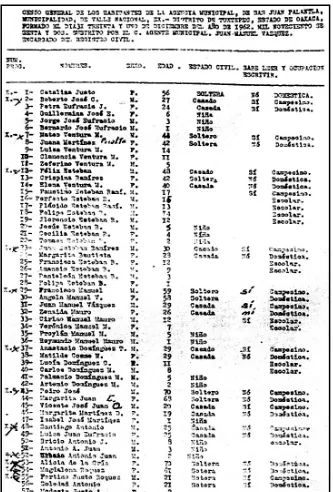
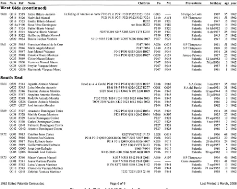
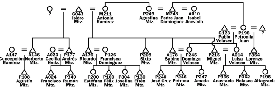
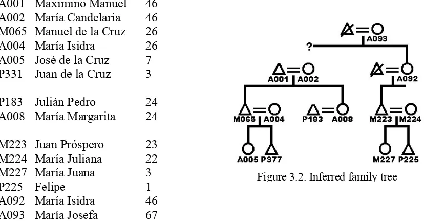
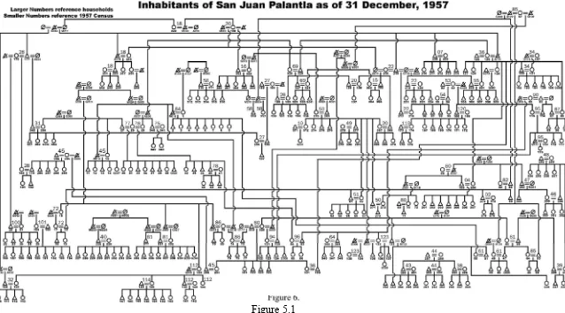
Apart from published forms of my own research and of many others that will be referenced throughout this study, several additional documents are very important to this narrative. One of the first things I did to help me effectively enter Palantla life was to obtain copies, first of the 1956 and 1957 Palantla censuses—documents produced at the end of each year as part of the responsibilities of the village Secretary. I made a sketch of village streets, paths, dwellings, and public buildings. I then made inquiry concerning the distribution of all residents among the various dwellings, and asked how all 357 members of the community, at that time, were related to one another filially and through marriage.
Many additional documents were later collected, although they were not all studied immediately. These included census lists from San Pedro Tlatepuzco, one list of males only from San Antonio Ocote and San Felipe de León, numerous other Palantla census lists, and birth and death records for several years. Most recently, with the aid of the computer, these lists have all been keyboarded or scanned and then assembled into a composite list of 15,409 lines of data, each line providing personal names, dates, ages, parents, children, place of birth, and reference codes for each individual. All records are not complete—we do not know everyone’s date and place of birth, parents, and so forth—but most are.
Individuals are identified throughout this study by reference to these lines of data in the following way. The 179 persons named in the 1920 San Pedro Tlatepuzco are referenced in order of their listing in the census as A001, A002, … , A179; the 191 individuals found in birth records from 1948 through 1957 are referenced in the order of their birth as B001, B002, … , B191, and so forth. Some birth records also include the names of parents and grandparents.
The complete list of documents of this type that I have been able to assemble for this study is as follows, with their corresponding reference codes:
A001–A179 1920 Census San Pedro Tlatepuzco
B001–B191 1948–1957 Birth Records
C001–C209 1921 Census San Pedro Tlatepuzco
D001–D250 1925 Census San Pedro Tlatepuzco
E001–E038 1921 Males San Antonio Ocote
F001–F053 1921 Males San Felipe de León
G001–G121 Parentage data (personal research)
J001–J515 1946 Census Palantla
K001–K345 1947 Census Palantla
L001–L364 1948 Census Palantla
M001–M374 1949 Census Palantla
N001–N340 1956 Census Palantla
P001–P377 1957 Census Palantla
Q001–Q351 1962 Census Palantla
R001–R306 1968 Census Palantla
T001–T315 1979 Census Palantla
U001–U362 1981 Census Palantla
V001–V380 1982 Census Palantla
W001–W421 1985 Census Palantla
X001–X443 1986 Census Palantla
Y001–Y234 1982 location of emigrants
Z001–Z117 1947–1954 death records
1001–1453 1987 Census Palantla
2001–2453 1988 Census Palantla
3001–3473 1989 Census Palantla
4001–4393 1991 Census Palantla
5001–5427 1995 Census Palantla
6001–6511 1998 Census Palantla
7001–7552 2000 Census Palantla
8001–8543 2002 Census Palantla
9001–9532 2004 Census Palantla
€001–€183 1991 Communal Land Request Just one primary reference code is chosen to identify each individual cited in this narrative regardless of how many sources reference that individual. The algorithm for choosing the primary identity reference for each individual is a bit complex, simply because the various sources of data came into my possession at various stages over the course of the study. This is essentially the algorithm:
1. Inasmuch as I first devoted intensive time to the 1957 census record, the primary identity reference of all individuals listed in the 1957 census is that of the 1957 census, which is to say, P001–P377.
2. The primary identity reference of any individual named in one or more of the Tlatepuzco census records, but in none of the subsequent Palantla census records, is that of the EARLIEST
Tlatepuzco reference code with which he or she is associated; i.e., Annn (1920) over Cnnn
(1921), and Cnnn over Dnnn (1925).
3. The primary identity reference of any individual named only in the San Antonio Ocote or San Felipe León lists of 1921 is that of the respective list; i.e.,Ennn (1921) or Fnnn (1921).
4. The primary identity reference of any individual who is only listed in Palantla census records prior to the 1957 census, is that of the MOST RECENT of those references; i.e., Nnnn (1956) over Mnnn (1949), Mnnn over Lnnn (1948), Lnnn over Knnn (1947), and Knnn over Jnnn
(1946).
5. The primary identity reference of any individual who is only listed in Palantla census records subsequent to the 1957 census, is that of the EARLIEST of those references; i.e.,Qnnn (1962) over Rnnn (1968), Rnnn over Snnn (1973), and so forth to 8nnn (2002) over 9nnn (2004). 6. The primary identity reference of any individual who is only listed in the 1991 Communal
Land Request, is that of that document; i.e.,€nnn (1991).
7. The primary identity reference of any individual who is only listed in a birth and a death record is that of the birth record: i.e.,by a Bnnn reference code.
8. References in relocation records (i.e., Ynnn references) or in death records (i.e., Znnn
references) are never cited as primary identities; references in parentage records (i.e., Gnnn
references) are only cited as primary identities for individuals for whom no other documentation is available.
I had no idea when collecting these early materials that I would ever undertake this particular study. If I had, I could have studied the materials more carefully at an earlier date when many questions that still remain could have been easily answered. I was very much interested in getting to know the people and understand their way of life, but my primary assignment related to the Chinantec language.
For illustrative purposes, I attach a photocopy of the first page of the 1962 census and a portion of the partially corresponding edited version (p. 7) that is part of the database assembled from all available data sources.
Names
I do not claim that every name found in the composite list of documents or in the related narrative is exactly the name each referenced individual has adopted as his or her own name. This would have required a personal interview with all of those individuals, which did not happen. The original documents do not always give full names of all individuals nor are they fully accurate. Many discrepancies in names and ages are found in comparing the available records. The reasons for the discrepancies are multiple. I have tried to choose a correct personal name for each person followed by correct surnames.
Scribal error is only part of the problem. All official records are created each year by the current town secretary, a man who is normally among the most literate and bilingual in the community. The Secretary, sitting at a typewriter2 in the town hall, typically assembles a new census almost exclusively on the basis of his personal knowledge of the community in any given year, without direct investigation beyond asking a question or two of a fellow town official. Not only are names misspelled, individuals and entire households are occasionally inadvertently omitted altogether from the record when they have most certainly been present in the community throughout the year. They are, from one year to the next, sometimes identified by incorrect names, since a current Secretary will often also rely upon a previous census when creating a new one.
2
A more significant problem in regard to personal names is that the Chinantec form of a Spanish personal name is the only name normally used, or even known, throughout the community. Such Chinantec names are usually, but not always, based phonologically on the Spanish name, but most of the people who use a name in daily affairs do not really know what a person’s real Spanish name is, not even the village Secretary. Since many Chinantec personal names can serve for a variety of Spanish names, the Secretary can easily get it wrong in the census. For example, Guii³liug¹³ may stand for Luciana, Luminosa, or Lourdes. Sø³tín³ may stand for Agustín, Justino, or Celestino.
Personal names are traditionally chosen at Christian baptism from a published list of Roman Catholic Saints associated with each day of the year, although the names of popular Mexican celebrities are now being chosen as the twenty-first century begins. Traditionally, however, a girl born on 2 February might be named María Candelaria because that is the date recognized in the church calendar for commemorating the Virgin Mary of Candlemas. Curiously enough, one man,
P282 Pedro Pablo Juan, is listed in the 1920 census as Pedro Pablo, where we would expect his surname to be Juan. The author suspected, and research later confirmed, that this young man was born on 29 July, the day in the church calendar that commemorates together the Apostles Peter and Paul. That very day was set aside in San Pedro Tlatepuzco, and later in Palantla, to honor
their Patron, San Pedro, whose image now stands in the prominent place over the altar of the Palantla church sanctuary. Having been born on the Day of Peter and Paul, it would seem that young Master Pedro Pablo Juan was given two personal names by his forebears. As it turns out, however, with an increased use of paternal and maternal surnames by the Chinantec people in recent years, Pablo was eventually recorded as his official surname, as well as that of his sons, no matter that his father and siblings bear the expected surname Juan.
The issue of accurate surnames is even more difficult. The Chinantec have not long used surnames in the consistent fashion found in the Spanish-speaking community around them. Standard Spanish usage is for an individual to take his or her father’s paternal surname followed by his or her mother’s paternal surname as their own. Roberto Hernández Maximino is, thus, so named because his father is Antonio Hernández Martínez and his mother is Virginia Maximino
Pérez. In the earliest available census records, Chinantec adult males are usually listed with one surname, but adult sons seem sometimes to be listed with their father’s personal name as their surname.
Furthermore, the ubiquity of certain surnames across several families in the community, or the use of personal names like Juan or Pedro as surnames by some, has motivated school teachers, in recent years, to introduce new surnames into the community by giving them to some of their students for one reason or another. One particular school teacher, Andrés Pérez Olivares, from Usila, who taught in Palantla in the 1940s, issued a number of surnames to his pupils, including Cabrera, Cardel, Ramírez, Vásquez, and probably others, but primarily as maternal surnames, which are less likely to be passed on to their children.
While early records usually list adult Chinantec males with one surname, women and children usually, until very recently, were listed without any surnames at all. After all, there was no normal use of a surname in Chinantec daily life. If there are more than two Robertos in the community, they are given nicknames like Fat Robert or Little Robert, which are often coined by peers based on a humorous event in their life. A certain young man in Palantla in the late 1950s was dubbed Quiu³ ‘his thigh’ when he was encountered with a young woman sitting on his lap (ni³ quiu³ dsa). Another was dubbed Jme³ ‘skunk’ after reportedly acting like an animal trying to sneak into its lair, after he had been seen with a young woman at the edge of town. For unknown reasons, all his peers refer to one fellow as Compadre Anastacio, in spite of the fact that he is not an actual compadre (a type of ritual kinsman) to all of them.
By comparing all available documents in a single file and by establishing, as best possible, the identity of each individual’s parents, personal names and surnames have been standardized, using standard Spanish practice except where there seems to be strong evidence that a different set of names has been adopted by the individual. I make no claim regarding absolute accuracy; only that an effort has been made to present as accurate a record as possible.
Ages
learned that such records are no longer filed locally, but rather at the civic offices at the municipal center of Valle Nacional. Their collection is also much more laborious, since each birth and death is now apparently recorded individually on a separate form, rather than in a bound ledger. In years gone by, apparently annual or semiannual composite reports were assembled each year, which made such data easier to access.
On the positive side, some more recent lists not only purport to state the age of an individual, but also an actual day of birth. The earliest records merely listed the current age of each person. But even the new, more complete information, appears to contain errors. We are often left only with an educated guess in regard to the ages of individuals. Represented dates of birth should, therefore, be considered in this light. There is no information at all concerning the ages of some individuals. Where there is information, be aware that dates are normally presented definitively to avoid constant repetition of approximating phrases.
Marriage
Chinantecs may marry in three ways. They marry traditionally by making arrangements between families or between individuals, as described in some detail later in this study. They marry at the church, either when the priest arrives in town for a major religious festival, or by travelling to a town that has a resident priest. And they marry politically, travelling to the town hall at a municipal center such as Valle Nacional. Some couples marry in all three of these ways, some just make a private pact and move in with each other, especially after a first liaison has failed or a first partner has died. Marriage is usually more formal today than it was in the early twentieth century, especially first marriages. I do not have official marriage records nor have I made serious inquiry into how each marriage partnership has been formed, although earlier census lists recorded the political status of older couples as ‘single’ if they lacked official sanction of their marriage by a trip to the town hall. In this study, when people are actually living together as spouses, I simply refer to this as marriage without reference to the legal niceties of how the liaison was formed.
Personal Identification
Chapter 2
The Founding of Palantla, 1501–1928
This study presents a detailed picture of one, small, Chinantec community, known as San Juan Palantla, as it has developed and changed through most of the twentieth century. This village, located within Valle Nacional municipality of the Tuxtepec district of the southern Mexican State of Oaxaca, is today populated by Chinantec people who hark back to San Pedro Tlatepuzco as their original home. Long ago, however, before the sixteenth-century conquest of Mexico by the Spanish, Palantla already existed as an important city of a great Chinantec Kingdom, then populated by a different Chinantec people who spoke a related, but different Chinantec language from that spoken by the Tlatepuzcans.
Of primary interest to us are the twentieth-century events and personalities associated with Palantla, but I also sketch the 400-year antecedents of this location and introduce the Chinantec as a larger entity and family of communities that speak a dozen or more related languages.
At the beginning of the twenty-first century, Palantla is a village of 101 homes and some 530 residents. It lies at 17° 51′ 00″N 96° 23′ 00″44″W, at the confluence of the Palantla River (along its eastern boundary) and an unnamed minor tributary (along its southern boundary), seven air miles WNW and 1500 feet above Valle Nacional. The village is situated in a small, sloping valley that rises, at first gradually, but very soon much more persistently to the north and west toward peaks high above that ring the valley about on all sides, with only a small enough rift below for the river to weave on through to lower altitudes.
Beyond the furthermost sources of the Palantla River to the west, and high above Palantla, lies Santo Tomás Tejas, whose water sources flow away from Palantla, to the west and into the Usila River that continues on to the Santo Domingo far upriver from its confluence with the Valle Nacional River. The two Tlatepuzcos, San Pedro and Santiago, lie upriver from Usila, far to the southwest of Palantla.
The most direct footpath up to Palantla from Valle Nacional runs from two kilometers or so south of Valle Nacional. In the final decade of the twentieth century that path became an unpaved, earth and gravel road that accommodates high-axle vehicles most days of the year. The road travels along the north bank of the Palantla River to Arroyo de Banco, proceeding in a northwest by northerly direction to Arroyo Palomo. Finally it runs over a high ridge above Arroyo Palomo and down to the Palantla River, perhaps five hundred meters below the southern edge of the occupied community of Palantla. From there, the village is organized by two parallel streets, here referenced fictitiously as
Main Street and Second Avenue respectively, which run at 311º to the Village Green.
Main Street leads up directly to the green, whose slope has been reduced by the creation of an uncut-stone retaining wall along its lower edge where Main Street meets it. This street requires a climb over large stones arranged as a rough stairway that makes other than foot passage difficult and impossible for vehicles. It is Second Avenue, to the right of Main Street that has become the through business route or camino real between Valle Nacional and Usila, providing the better approach for riding animals, beasts of burdens, and more recently, motorized vehicles, to reach the upper end of the village or to pass on through to Santo Tomás Tejas. A San Lucas family currently has the transportation franchise and runs at least two small trucks for passengers and cargo between Palantla and Valle Nacional several times a day from early morning to dark.
Pigs and turkeys that once roamed the village, polluting the trails with their waste, are no longer seen since the government began to require that they be fenced in, resulting in most families finding that it was not worth the bother to raise them. Each home now has a government-required outhouse as toilet. Water is run to a spigot in each patio through plastic tubing from concrete water-collection tanks built at the source of three major springs emerging from the foot of the hill that arises directly behind the village to the NW. This water has been tested and found suitable for drinking without treatment.
To accommodate the installation of electric power in the community in the 1980s, the layout of the community was modified to provide a grid of new streets required by the government before they would plant the power poles that now support lines that bring electricity into each home. A single satellite telephone in one home now provides communication with the outside world as long as the telephone bill is paid, which is not all the time. The school situation has blossomed from a single non-Federal school teacher in the 1950s who knew no Chinantec, to a half dozen or so teachers, some of whom speak one or another Chinantec language, and instruction from preschool to satellite-assisted middle-school education.
been replaced almost completely by concrete block homes with flat concrete roofs and floors. These houses are paid for by cash income from the production of improved coffee plantations introduced with direct encouragement and assistance of the Mexican government in the 1980s. This situation moved the Chinantec from a primary dependence upon maize for subsistence, a crop they no longer grow in any large measure, to a primary dependence upon cash in the world coffee market. Wooden beds and mattresses have replaced woven straw mats cushioned by crushed sugar-cane-stalk mats laid out on an earthen floor. Hearths consisting of three rocks on the floor to support a clay griddle have been raised to waist-high cooking tables, often enshrined within brick shelves and complete with chimneys, but still utilizing the traditional rocks, clay griddle, and requiring fire sticks gathered from the countryside.
In 2005, most every Tlatepuzcan home in the region had one or more family members illegally in the U.S., working to help pay the inflationary costs of contemporary rural Mexican life. The following narrative will perhaps help to explain the antecedents of this present situation.
Who are the Chinantecs
The Chinantec people are not well known to any but a few scholars. Those who have studied little of the linguistic diversity of pre-Columbian Mexico have perhaps heard only of the Aztecs or the Mayans, whom many incorrectly assume to have long
ago disappeared from view at the hands of Spanish
Conquistadores. Not so. There are hundreds of thousands of Aztec and Mayan speakers living today in the twenty-first century in Mexico and Guatemala, and many others who, though they no longer speak the languages, recognize their pre-Hispanic heritage.
But the Mayans, once the architects of a great civilization, reside at the far southeastern edge of Mexico, from the State of Chiapas eastward and throughout Guatemala. They probably never occupied, in any significant measure, territories to the north and west of their present locations.
On the other hand, the Republic of Mexico today bears the very name of the Mexica [me´sheekä] warriors who ruled the land from their great capital city Tenochtitlán when the Spaniards arrived, a city that is Mexico City today. These were the ‘Aztecs’, reportedly originating before descending
into Mexico in a land called Aztlán ‘land of the heron’. These Aztecs ruled most of the territory now known as Mexico and extracted annual tribute all around. However, they had not subdued all the peoples of the land nor did they by any means occupy all of the territory other than by small military garrisons spread across the countryside to keep order and extract tariffs. More importantly, these Aztecs were relatively late-comers to the area, from this mythic, northern land of Aztlán.
The Otomangueans
Otomangueans, a family of peoples who long ago settled on and populated large territories of Mexico from what is now San Luis Potosí in the north to the Isthmus of Tehuantepec in the southeast and even, in pre-Hispanic times, to Nicaragua in Central America. The late-arriving Nahuatl-speaking peoples that included the Aztecs settled among the Otomangueans, but the latter had preceded them into the land.
The Otomanguean languages constitute a stock of language families, of which the Chinantec family is but one. Otomanguean is, thus, not unlike the stock of Indo-European languages that includes families of languages such as the Germanic and Romance languages to which English and Spanish belong. Otomanguean languages are still spoken by several millions of native peoples of Mexico today. They live hundreds of miles north of Mexico City and on down to the southern State of Oaxaca, where most of them are now found.
The Chinantec peoples speak a dozen or more languages of one of these families, and are linguistic cousins of the Zapotecan peoples, the Otopamean peoples, the Mixtecan peoples, and several others. The Chinantec home territory lies
in a narrow strip along the eastern slopes of the Mexican Sierra Madre at the northern edge of the southern Mexican State of Oaxaca, within the Districts of Tuxtepec, Choapan, Ixtlán, and Cuicatlán.
The immediate neighbors of the Chinantecs are the Zapotecs to the South, the Cuicatecs to the West, the Mazatecs to the Northwest, and the Popolucas to the North and East. All of these are Otomangueans except the Popolucas, whose language pertains to the Popoluca-Mixe-Zoque family with affiliations that are not altogether known, but who are most likely distant linguistic cousins of the Mayans who live further to the east. Their ancient territory separated southern Otomangueans from the Mayans at the border of what is now the Mexican State of Chiapas.
Tlatepuzco Chinantecs, the subgroup of Chinantecs that constitutes the focus of this study, have little or no memory of the Popoluca today. At an early stage of research, I was given the Chinantec term Hiigh³ for a people who formerly lived in or around Tuxtepec. Forty years later, younger speakers have no knowledge of this word which, for lack of confirmation, was not included in the published version of the Chinantec–Spanish Spanish–Chinantec bilingual dictionary (Merrifield and Anderson 1999). These supposed former inhabitants of Tuxtepec may very well have been Popolucas since Espinosa (1910, in Cline 1961:132) reported that the Spanish- and Aztec-speaking inhabitants of the region were ethnically Popolucan. Or, less likely, the term may have referenced the Aztecs who were garrisoned there to collect tribute at the time of the Spanish conquest. We cannot be sure.
The Tlatepuzco Chinantecs have names in their language for their Otomanguean neighbors, the ZAPOTECS (Nøng²), CUICATECS (Quiun¹²), and MAZATECS (Chieg³). The languages these
The fifth term, Lih² ‘ladino’, names native speakers of Spanish. It is possible that Hiigh³ may have once belonged to this set, referring to the Popoluca or, perhaps, to Aztec overlords.
Internal Diversity
The Tlatepuzcans have no single word that sets all Chinantecs apart as speakers of a Chinantec language. They must resort to a circumlocution, dsa² hløah¹² jǿg³ jmei¹² ‘those who speak the Chinantec language’, that is opposed, for example, to dsa² hløah¹² jǿg³ ŋiíh¹ ‘those who speak the Spanish language’, where the derivational reference of jǿg³ jmei¹² could possibly be from ‘unseasoned words’ and jǿg³ ŋiíh¹ from ‘salty words’.
But the Tlatepuzco Chinantecs do have terms for several distinct Chinantec subgroups. These are elaborated upon in Merrifield 1966,1 but the essence is that six lowland neighbors of the Tlatepuzcans, and the Tlatepuzcans themselves, are today referenced by simple phrases, of the form dsa² X ‘X People’. In each case these peoples are associated with an ancient civic
center that is correspondingly named jø³juøi² X ‘X town’. With only one clear exception, these phrases seem to be derived from animal names. The derivations are not certain, but suggest emblematic relationships. The seven phrase pairs are listed below in association with the word that names the supposed emblem:
1. dsa² cøh³ ‘Tlatepuzco People’ Jø³Juøi² Cøh³ ‘Tlatepuzco’ cøh¹³ ‘lizard’ 2. dsa² hiég³ ‘Chiltepec People’ Jø³juøi² Hiég³ ‘Chiltepec’ hiég³ ‘spider wasp’ 3. dsa² huøin³ ‘Ojitlán People’ Jø³Juøi² Huøin³ ‘Ojitlán’ huøin³ ‘lacewing’ 4. dsa² jinh² ‘Usila People’ Jø³Juøi² Jinh¹ ‘Usila’ jinh² ‘black wasp’ 5. dsa² møi² ‘Hawk People’ Jø³juøi² Møi² ‘Valle Nacional’ møi² ‘hawk, eagle’ 6. dsa² tien¹² ‘Tepetotutla People’ Jø³Juøi² Tien¹² ‘Tepetotutla’ tan¹² ‘bird’ 7. dsa² mu¹jai³ ‘Ozumacín People’ Jø³Juøi² Mu¹jai³ ‘Ozumacín’ mu² jai¹² ‘emaciated’
Unfortunately, there is no documentary or other known corroboration of this system of terminology to tie it more securely to Chinantec prehistory.
Palantla’s Early Roots
As indicated above, San Juan Palantla, the particular community that is the topic of this study, is reported to have first been founded in 1501 A.D. The brief historical synthesis that follows is due primarily to the very important ethnohistorical work of the late Dr. Howard Cline, who took
1
a special interest in Chinantec matters, as well as an early, personal interest in my own development in Chinantec-related pursuits. It was Cline who undertook to gather together a comprehensive bibliography of the known sources of Chinantec research up through the 1950s and to actually search out and republish or replicate a number of very old and otherwise obscure manuscripts, cloth diagrams, and maps of ancient Chinantec materials (e.g., Cline 1960, 1961).
One of the sources that Cline has made available to us is the work of a remarkable Tuxtepec schoolmaster with a deep interest in matters Chinantec, Mariano Espinosa (1910, in Cline 1961). Cline lauds Espinosa for much of what he has done to make the Chinantec people known, but also cautions us concerning the dependability of certain details, such as that of very early dates and of specific information concerning early Chinantec culture and religion, among other things. Espinosa’s audience was elementary students of the Tuxtepec region, in whom he intended to instill a sense of pride in their cultural heritage. He does not, therefore, document his sources in the manner we expect of a more technical presentation. We will try to take this weakness into account in the following synopsis.
Catastrophic events
There were, of course, wars. The Chinantecs fought among themselves; they fought their linguistic neighbors, and they fought the Aztecs. They are not known to have fought the Spanish; but, rather, they assisted Cortez in his fight with the Totonacs of Cempoala (Bevan 1938:47). But in addition to wars, Espinosa includes numerous references to two other major factors that dramatically effected change in Chinantec demographics over the six hundred years his account spans, namely, highly destructive floods and devastating plagues. In his introductory chapter, Bevan (1938) provides an apt description well worth reading of the beautiful and, yet, overpowering rain forest that “binds the Chinantec down to his surroundings, fighting for his very existence, and fighting no human adversary but a wild forest whose strength is continually fortified by the almost incessant rains” (p. 10).
These rains have brought numerous, town-destroying floods through the years of the very type that destroyed San Pedro Tlatepuzco on 6 July 1928, precipitating the rebirth of Palantla by those who fled from it. Espinosa records no less than three major floods of this type in one ninety-year period: at Gran Chinantla in 1482, at the Tlatepuzcos in 1507, and at Ozumacín in 1572.
We now know that it was the Europeans who unknowingly brought such diseases as measles, smallpox, and typhus to the New World which decimated Native Americans from New Foundland to Tierra del Fuego. The Chinantecs did not escape this threat. Espinosa records six terrible plagues that destroyed entire villages and precipitated dramatic relocations of people. The first mention is at Tecalco in 1527, then at Chapultigupe in 1565, at Pexidiana in 1570, at Tecalco again and Tecalco Tepilepi in 1571, at Moyulteptl in 1601, and at Palantla in 1609. In his 1569 Chinantec Report, the Spanish Chief Magistrate of the city of Chinantla, Diego de Esquivel, reported to the King of Spain that pestilence had reduced just the district under Chinantla’s jurisdiction from 100,000 fighting men to a total population of 1,000 subjects (Bevan 1938:136). In the corresponding 1579 Usila Report by Hernán Quijada (Bevan 1938:129–34), the Spanish Chief Magistrate in that town, reports as follows:
La Gran Chinantla
Espinosa provides a striking picture of various cycles of existence of the great, lost City of Chinantla. I begin here with an English rendition of some of his prose that romantically portrays the splendor of this early Chinantec capital, then situated on the west bank of the Valle Nacional River, near where the Palantla River flows into it:
The time at which this city was flourishing is unknown, when its kings and lords were raising their weapons in victory over all the lands they had contended for against innumerable tribes who in their long pilgrimages traversed its territories, perhaps with a strong desire to take possession of it, or against conquering tribes like the Cuetlalchinca.2
The City of Chinantla, flourishing and majestic, rises on the banks of its river; and its founding king, shrouded in myth, has been transformed through the ages into a God who, proud of his empire, contemplates his subjects from his granite throne as they prostrate themselves before him, offering him praise and laying their gifts at his feet. (translated from Cline 1961:77)
Among other things, Espinosa presents a catalog of ancient Chinantec communities, which, he says, were given Aztec names because of the inability of the conquering Aztecs to comprehend the Chinantec language (Cline 1961:78). I will recount below from this informative presentation primarily those details which name or provide context for the earliest known history of Palantla.
900–1100 A.D. Chinantla (a Nahuatl term of disputed derivation) is said to have been founded in 1110 A.D. Espinosa gives no support for this date, nor is any available to us. But Cline, in original sources unavailable to me concerning early Zapotec land wars in the region (fn., 1961.75), calculates that Highland Chinantecs of Yólox successfully fought neighboring Zapotecs ca. 940 A.D., forcing them back and requiring them to found early Ixtepec (Ixtepeji), which continues today to lie at the boundary between Zapotec and Chinantec territories.
1300 A.D. Espinosa then says that between 1240 and 1305, the Chinantec kingdom was divided because of infighting between two royal brothers, one part of the kingdom encompassing areas lying west of Palantla, the other part being precisely the area of our more specific interest.
Towns specifically named that relate to this first group are Yólox, to the southwest in the Sierra de Juárez, Usila, which lies at a six-hour walk immediately west of present-day Palantla, and Ojitlán, that lies at the far northern edge of Chinantec territory, but visible from the heights of Cerro Armadillo that today pertains to the area of our interest. This southern-highland to western to northern-lowland region of the ‘Chinantla’ has been called the Chinantla Pichinche, which Espinosa claims referred to their ancient hair style, borrowed from the Mixtecs of SW Oaxaca, who are said to have shaved their heads, except for a small circle of hair in front (Cline 1961:88).
2
The people of the second region of the kingdom, referred to as Lowland Chinantec, are said to have let their hair grow long. This kingdom, and the name of its Capital City, were called La Gran (grandiose) Chinantla.
Another major region of Chinantecs, that lays SE of the Cajonos River, in the drainage of the Chiquito, Manso, and Lalana Rivers, separated from Yólox and other communities of the southern highlands by Zapotecs, goes without mention in this early narrative.
1400 A.D. A further division reportedly took
place in 1420 A.D., due to civil wars, resulting in three feudal estates: Yólox, Usila, and Chinantla, essentially splitting the Chinantla Pichinche. Fifty years later civil wars between Lowland and Highland Chinantecs caused the abandonment of ancient Cuasomulco, on the border between them on the northern slopes beneath Mount Cuasimulco, the tallest peak of the region.3 And then, about the same time, the Zapotecs returned the town of Temazolapam to the Highland Chinantecs in order to encourage an alliance together against an emerging Aztec threat.
The Aztec ruler, Moctezuma I, enters the scene to conquer the Chinantecs in 1457; and a few years later, in 1464, the northern-lowland village of Chiltepec at its early location (Pueblo Viejo)4 comes into view, when its inhabitants, along with unnamed others, emigrate southward into the Cojonos River valley in apparent response to an Aztec threat from the coastal north. They move toward Ozumacín and the territory of the southeastern Chinantecs referred to above.
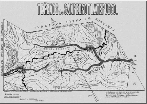
Espinosa also reports that a significant portion of the lowland capital city of Chinantla was destroyed by flood around 1480. The city seems to have been located near the southern end of the Valle Nacional valley at that time; but this was not its earliest known site. Esquivel (1569) indicates that the city of that era was named for an earlier one located perhaps twenty-five miles [eleven leagues] upriver from it. The best guess at this earlier location of Chinantla is probably near the headwaters of the Nopalera River near present-day Nopalera del Rosario, in the next valley north of where ancient Cuasomulco stood.
However, by 1480, Chinantla thrived in a broad valley, on the west bank of the Valle Nacional River. Above average flash floods must have descended from one or more of the several upriver sources of the Valle Nacional River—the Palantla, San Felipe, Nopalera, and the Cuasimulco Rivers—causing it to overflow its banks to the point that many of its inhabitants were forced to move to a new location. Espinosa indicates that this first move was just about a mile away, probably further upriver and keeping to the west bank of the river, where they founded the town of Teanguisco, which lasted only a few decades.
1500 A.D. During the sixteenth century, there was a bewildering sequence of movements between the National Valley and upriver locations near the sources of the Palantla, and perhaps, San Lucas Rivers. Before this, however, Chinantec farms were undoubtedly to be found all
3
Also, Cuasomulco, known to Palantla Chinantecs as Cerro Pelón (mah¹cuuh² ‘bald mountain’) because its peak rises well above the tree line.
4
across the Chinantla landscape, including the higher elevations along these rivers. But then, larger population movements took place, from time to time, changing the overall picture.
1501 is the otherwise undocumented date that Espinosa gives for the first founding of Palantla
as a town. Those who had been forced by flood from the City of Chinantla, after only a short time in their new, nearby town of Teanguisco, abandoned that location and removed to the headwaters of the Palantla River, well above the 1500-foot elevation of today’s village of that name. Here is Espinosa’s account in translation:
About 1501 A.D., the inhabitants of the Gran Chinantla arrived at [Palantla] after having remained in Teanguisco for 52 years.5 … At that time Palantla was situated 2½ kilometers from the small ranch which is today called Agua Paloma.6 … With the arrival of new inhabitants the town grew and, as indicated above, it pertained to the royal line; so it continued to govern those Chinantec towns that remained, because many people had moved away and others had died [in the plagues] … Although they were subject to paying tribute to the king in Mexico City, they also continued to recognized their own king; but in view of new years of such extreme famine that they were reduced to eating herbs from the forest, they had to move back to where they planted their winter corn crop, called tonamil, which they accomplished in low country, returning to live at a place near the ruins of Teanguisco which in 1542 came to be known as Provincia Real, and leaving in Palantla only a few inhabitants and some early residents of that location. (Cline 1961:81f)
In 1565, the little-known but reportedly long-standing community of Chapultigupe (by Espinosa’s description must have been situated somewhere near the current locations of San Antonio Ocote and San Isidro Laguna, one valley to the southwest of the Palantla of today) was abandoned because of an unnamed pestilence; and its inhabitants are reported to have gone to live in Palantla.
About 1569, … it was decreed that these peoples should congregate together into communities, and the people of Provincia Real petitioned to establish a town at Palantla, at the foot of the peak of that name, four kilometers to the north of its old location.
After 142 years of living in this location [i.e., to 1711–1712],7 [they finally received title to their] lands and waterways, but in 1609 a terrible typhus fever had so decimated them that the only 31 families who had remained to that time where they had established themselves had to leave for the current [town of] Valle Nacional, in possession of the title to Valle Real in memory of their noble heritage. (Cline 1961:82)
We are indebted to Cline for having researched national archives in Mexico and Europe to recover documents of Chinantec interest, including the title documents referenced in the preceding 1910 quote from Espinosa. Among other things, these title documents indicate that the Palantla of that era continued to be the Administrative Center (Cabecera) of the entire region of the Valle Nacional River basin, including the upriver town of San Pedro Ozumacín in the south, San Mateo Yetla at the upper end of National Valley, and Santa María de la Asunción Jacatepec at its downriver end; thus, it was all the territory between Zapotecan Villa Alta in the south, Tuxtepec in the North, and Usila and Ojitlán in the west.
5
Only a few pages earlier these fifty-two years are stated to be thirty-two years. A further problem is that it is only twenty-one years between the reported 1480 founding of Teanguisco and the claimed 1501 founding of Palantla.
6
Chinantecs call this village, San Lucas Arroyo Palomo. The actual current distance is closer to 5–6 kilometers.
7
Two Palantla locations
There seem to have been at least two locations where Chinantecs from the valley had gathered into congregated communities they called Palantla. And, as a matter of fact, there are two known locations where old church ruins are to be found. One of these I have seen, the other I have not. The first is located immediately north of and across the small path from the 1957 Palantla household at !R114 [see below], covered by forest growth. It was a stone building of which only the wall foundations and some rubble remain. Chinantec friends have told me of the second location, where an ancient community reportedly existed on Cerro Campanario (máh² u²guøh¹²), a peak which lies beyond the high ridge that stands to the north of present-day Palantla. That location was apparently between the headwaters of the Palantla River and those of the San Lucas River to the east, which runs down past the tiny settlement of Santo Domingo (Máh² Dsii³ Lah³) to join the Palantla River at San Eulogio Arroyo de Banco. Spanish
campanario means ‘bell tower’ and Chinantec Máh² U²guøh¹² means ‘old church mountain’. I have been told that the ruins of an old church are to be found there.
I have also been told that there is evidence of a former settlement long years ago on top of Mount San Eulogio (Máh² Sø²u²ló³), which lies two or three hours almost due north of Palantla, probably also of the so-called Hawk People.
The full ecclesiastical name of Palantla is San Juan Palantla. It was in one or both of these earlier locations, presumably, that the San Juan of today’s San Juan Bautista Valle Nacional was originally revered, before his final departure to the valley below in the early eighteenth century. Palantla today continues officially to bear John’s name, but the resident patron of today’s Palantla church house is Saint Peter, brought from San Pedro Tlatepuzco. After John’s departure, we have no evidence that Palantla existed as a community until it was repopulated from San Pedro in 1928. Espinosa wrote in 1910 that “today, in Palantla, only ruins and a few farms are to be found” (Cline 1961:82).
The Languages
One very important fact needs to be mentioned about these peoples of Chinantla, Teanguisco, Palantla, Provincia Real, and Valle Nacional (and very likely those of Chapultigupe and others), who occupied early Palantla and its environs; namely, these peoples spoke a different Chinantec language and are of a different immediate heritage than the Chinantecs from San Pedro Tlatepuzco who inhabit this entire region today, from Nopalera in the south to Arroyo Frijol in the north. These people were the descendents of the Gran Chinantla with their noble king of great influence throughout his wide domain. They are known by today’s residents of Palantla as Dsa² Møi² ‘Hawk People’ of Jø³juøi² Møi², ‘Hawk Town’, today’s Valle Nacional; whereas San Pedro Tlatepuzco folk are called Dsa² Cøh³ ‘Lizard People’ and San Pedro Tlatepuzco Jø³juøi² Cøh³ ‘Lizard town’, before it was reduced to the small village of today.
San Pedro Tlatepuzco. There are two Tlatepuzcos, San Pedro and Santiago (St. Peter and St. James). In Chinantec, the village of San Pedro, which lies 1.5 hours-walk upriver from Santiago, is called Cøh³ ŋií² ‘upriver Tlatepuzco’, while Santiago is called Cøh³ quiín² ‘downriver Tlatepuzco’. Santiago lies 2.5 hours walk upriver from San Felipe Usila.
place it far downriver from Usila towards Ojitlán and separated a great distance from the two Tlatepuzcos of today, raising some doubt that this is actually to be identified with the Santiago Tlatepuzco of today. Today’s Santiago is close to San Pedro, and the languages of the two towns are linguistically very close, which is not the case for either Usila or Ojitlán.
The Ayotixtlas (or Ayotustlas, as they are called in the 1579 Chinantla Report, Bevan 1938:136; Cline 1961:202), are listed as dependencies of the City of Chinantla of that day, along with Palantla, Yetla, Ozumacín, and Jacaltepec, among others. It should be noted that, unless there were complete changes of population in some of these towns that we do not know of, the peoples of Chinantla, Yetla, and Jacaltepec, of that day, formed a closely related linguistic group. On the other hand, Ozumacín was very likely already somewhat more diverse, as were the two closely-linked Ayotixtlas, which have become the two Tlatepuzcos we know today. Espinosa reports that two Ayotixtla chieftains separated the community into two areas in 1462, with the Santiago group eventually moving from a location upriver from San Pedro to a downriver location closer to Usila (Cline 82f).
Espinosa later reports (Cline 1961:136f): “In 1810, [San Pedro Tlatepuzco] was a village of significance, having 110 indigenous families, producing maize, rubber, sarsaparilla, and much vanilla at a value of $10,000 pesos, being under the civil authority of the Mayor of Teutila.” San Felipe de León, Nopalera del Rosario, and other smaller ranches were among the outlying farming communities that related to it. By 1910, the population is said to have been reduced to only 790 individuals of both sexes. In 1810, San Pedro is said to have been twice as large as Valle Nacional and Usila and half again as large as Ojitlán; but 100 years later, these three communities are two-, three-, and six-times the size of San Pedro. The Cøh³ people had begun to move away from the immediate jurisdiction of San Pedro and Teutila, to places like Cerro Armadillo, San Lucas, Ocote, and elsewhere, in the jurisdiction of Valle Nacional, Tuxtepec, and beyond.8
Four summary statements from Manuel Martínez Gracida
Early in my research among the Chinantecs, I somehow came across a page of four paragraphs (most probably due to Howard Cline or Roberto J. Weitlaner), which I copied from a larger work by Manuel Martínez Gracida (1883), that present substantially the same record of origins as has been presented above (with differing dates, however) for four ancient Chinantec
8The following comparative population numbers can be extracted from Espinosa for several of the Chinantec towns
and villages in 1810 and 1910, respectively. Note that the 1810 numbers reference families, while the 1910 numbers reference persons.
Population (from Espinosa) 1810 1910
Municipalities: Families Individuals
Ojitlán 78 4,526
Usila 52 2,346
Valle Nacional 51 1,970
San Pedro Tlatepuzco 110 790
Agencies:
Ozumacín 52 1,950
Tepetotutla 75 890
Santiago Tlatepuzco 60 564
Jacatepec 29 500
Chiltepec 120 481
San Antonio del Barrio 420
Analco 326