Similarity of Drainage Basin Morphometry Development on
Quarternary and Tertiary Rock Deposits as a Measure of
Neotectonic Intensity in Bumiayu Area, Central Java
Febri Hirnawan
ABSTRAK
Batuan Tersier dan endapanvolkanik Kuarter yang tidak selaras di atasnya
sebagai produk Gunung Slamet, yang
terdeformasi, menentukan perkembangan
morfometri Daerah Aliran Sungai Pemali di
Kecamatan Bumiayu, Jawa Tengah dan
sekitarnya. Dalam riset ini, morfometri di daerah penyebaran kedua satuan batuan itu dipelajari sebagai gejala morfometri tektonik dalam artian pengaruh neotektonisme, yang mengakibatkan kerusakan infrastruktur.
Hasil-hasil uji regresi-korelasi antara azimuth segmen sungai dan kelurusan di kedua satuan batuan yang berlainan usia tersebut adalah signifikan, yang menunjukkan nilai-nilai tinggi dari koefisien korelasi masing-masing r1 = 0.999
dan r2 = 0.998, yang memberikan kesimpulan
kuat bahwa tektonik sangat berperan dalam mengontrol proses perkembangan morfometri.
Selanjutnya, uji beda rata-rata terhadap kedua
variabel itu dan juga terhadap nisbah
percabangan sungai (Rb) dan kerapatan
pengaliran (Dd) dari dua DAS yang berkembang
pada masing-masing satuan batuan tidak berbeda secara signifikan. Hasil uji ini memberikan kesimpulan bahwa perkembangan DAS tidak dipengaruhi oleh jenis batuan tetapi lebih oleh pengaruh pola deformasi. Fenomena ini menunjukkan bahwa tektonik masa kini aktif sehingga menghasilkan pola-pola kekar yang sama pada Formasi Halang dan Formasi Kumbang, dengan pada endapan volkanik sama pada Formasi Halang dan Formasi
Naskah masuk: 9 November 2008 Naskah diterima: 8 Februari 2009
Febri Hirnawan
Faculty of Geological Sciences and Engineering Padjadjaran University
Jl. Raya Bandung-Sumedang Km. 21 Jatinangor 45363 e-mail : [email protected]
Kumbang, dengan pada endapan volkanik Kuarter, yang secara menerus deformasi itu telah memotong bidang ketidakselarasan antara kedua formasi dan endapan Kuarter tersebut.
Kata kunci: morfometri, neotectonisme, segmen
sungai, kelurusan , keterbatasan wilayah
ABSTRACT
The deformed Tertiary rocks that unconformably overlying Quaternary volcanic deposits as product of Slamet volcano determine the development of morphometry of Pemali river basin in SubDistrict of Bumiayu, Central Java and its vicinity. In this area, the morphometry of this two rocks units distribution is studied as tectonic morphometry, in terms of neotectonism effect, which caused infrastructure damage.Results of regression-correlation tests between azimuths of river segments and lineaments in both rock units of the different age are significant, as the correlation coefficients are r1 = 0.999 and r2 = 0.998 respectively. It strongly suggests the tectonic control in the morphometry development process.
On the other hand, tests of difference averages between those two variables and also bifurcation ratio (Rb) and drainage density (Dd ) from two river basins that developed in the respective rock units are not significantly difference. The result suggests that the drainage basin development is not affected by any kinds of rocks, but merely by the deformation pattern. This phenomenon indicates that recent tectonic is active, which generated similar joint patterns in both Tertiary Halang and Kumbang Formations to that in the overlying Quaternary volcanic deposits, which continuously intersecting the unconformity between the rock units to the surface.
2 recent tectonic activity in Bumiayu Area, Central Java (Hirnawan, et al, 2007). This phenomenon is similar to the Cijolang and Cimuntur River Basins morphometry in eastern West Java, which is determined by recent tectonic activity being manifested by the active Citanduy and Baribis Fault Zones (Hirnawan, 1997). Methodology used in these researches is the verification of hypotheses regarding river basin developments as the effects of neotectonic activity, also known as neotectonism or recent tectonism, by using statistics. Tectonism or diastrophism is a general term for all movement of the crust produced by all tectonic processes, including the formation of ocean basins, continents, plateaus, and mountain ranges (Bates & Jackson, 1984; McNeil, 1999). Tectonism should be more suitable for the more specific term.
It has been well known that statistical analyses used by many authors for geomorphological approach before 1960s (Doornkamp, 1986). Some present authors used these analyses for measuring the effects of either reverse or strike slip fault on joint configuration patterns or bedding plane mean orientation values developing in the rock block separated by these faults in 1987 (Hirnawan, 1987). Geomorphological approach of drainage basin developments in eastern West Java mentioned earlier had been successfully conducted using statistics to verify the similar deformation pattern and density of joints both in Quaternary and that
in Tertiary rock deposits as a measure of “how far” is the effect of neotectonic intensity on
tectonic morphometry (Hirnawan, 1997), instead of usual approach of descriptive characterizations.
This approach and method are then widely used by some students of post graduate program of geosciences in his university to conduct their hypothetico-deductivism researches of phenomena, such as erosion, volcanic products of Merapi volcano, distribution of fosils bearing
beds, sedimentary facies, etc., including the tectonic phenomena, in which he is involved as one of the supervisors. The result of research of a student in Kulon Progo mountainous region, for example, suggested that tectonic activity since Eocene tectonic period generated similar drainage basins developments in Tertiary marine sediments, encompassing five formations, to that in Quaternary rock deposits (Budiadi, 2008). In this region the occurrences of three tectonic deformation patterns were successfully verified as had been originated from Sumatera-, Java-, and Meratus tectonic patterns. This powerful conclusion, as one of ten verified hypotheses in this research, had not only been the support of previous interpretations in terms of hypotheses proposed by many authors, which have not been tested before, but had also measured the tectonic intensity determining the tectonic morphometry developments in three chronostratigraphic systems in the mountainous region.
4
1996). These rock strata have been being deformed by continuous tectonic activity since post Tertiary up to Quaternary tectonic periods generating anticlines and synclines, joints, and faults, which are exposed in the surface. Joints and faults show indications of lineaments in the satellite imagery, along which generally river segments develop. Many river segments construct the neighboring subriver basins which eventually generate a large main river basin.
The development of drainage basin morphology is affected by the geological factors, including fluvial processes, topography, sea-level changes, tectonic activity and other factor like climatic condition (Doornkamp, 1986). As the result of the dynamic condition of the basin and the climate in a region where the surface run off flows to the lowland into the sea following the pattern of geological weaknesses encompassing joints, faults, bedding planes and other discontinuities, such as unconformable surfaces, the characteristics of drainage pattern morphology of river basins are generated (Stewart and Hancock, 1994; Hirnawan, 1997; Keller and Pinter, 1999). Active tectonic movement plays an important role affecting the development of the river basin morphology (Hirnawan, et al., 1998; Hirnawan & Muslim, 2006). Surface fault and/or recent flexural deformations are good indicators to the surface movement characterizing the neotectonic activity (Nakata, et al., 1996).
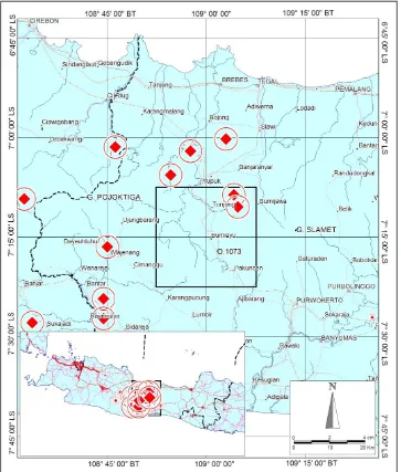
The researched area encompasses four respective regencies of Banyumas, Purwokerto, Brebes, and Tegal, Central Java, in which the Subdistrict of Bumiayu is located more or less in the middle part of the area (Figure 1). In this area indications of recent tectonic activity occur, which are exhibited by frequent shallow earthquakes, followed by deformations, such as joints, which cause damage of roads, houses and other structures. Besides, landslides and other types of rock mass movements frequently happen.
In this area, Tertiary marine sedimentary rocks are divided into more than eight litho-stratigraphic units, but Halang and Kumbang Formations representing the sedimentary rock
strata are studied together with the unconformably overlying Quaternary volcanic deposits of Slamet volcano.
The objective of this study is to examine whether morphological development of river basin on Quaternary volcanic deposits is governed by the pattern and density of recent deformation. If so, it would be the evidence of active tectonism. If the tectonic movement is active, both the Quaternary volcanic breccia unconformably overlying the Tertiary sediments and the sediments themselves should be deformed and may serve as the recent surface deformation, governing all the morphological developments of river basins, including those occurring on the youngest rock unit. The morphometry of the rivers on this Quaternary rock unit would resemble that on the Tertiary rock unit due to the neotectonic activity or neotectonism. This hypothesis should be verified using morphometry and deformation data.
Outline of Geology
The stratigraphy, structural geology, and geomorphology portraying the geological condition of the researched area are as follows. Two geochronostratigraphic units, known as systems, occurring in the study area are Tertiary marine sedimentary rocks and the unconformably overlying Quaternary volcanic deposits. In addition, the Tertiary chronostratigraphic system encompassing Pemali, Rambatan, Halang, Kumbang, Tapak, Kalibiuk, and Kaliglagah Formations are distributed in the southwestern side, whereas the Quaternary system consisting of volcanic breccia, tuff, and lava is in the northeastern side of the study area.
Majalengka Regency to eastern side of Banyumas Regency. In the upper part, this formation interfingers with sandstone and sedimentary breccia of Kumbang Formation, which is mainly distributed in the northern side of Subdistrict of Bantarkawung.
Sandstone beds of the Halang Formation are characterized by well developed stratification, and fine to medium grainsize, limy sandstone, sedimentary structures of graded bedding and parallel lamination are observed in several exposures. Claystone beds of the Halang Formation are characterized by well developed stratification, and grayish color. Limy and shaly claystones are commonly found in the field. Sedimentary structure especially parallel lamination is observed. In many other areas, outside the study area sandstone and claystone exposures of the Halang Formation indicate complete sedimentary structures of a, b, c, d, and e intervals belonging to the turbidite facies model (Bouma, 1976 in Simandjuntak, 1980).
The Kumbang Formation predominantly consists of sedimentary breccia and coarse sandstone beds intercalation. Sedimentary breccia of this formation is characterized by massive to poorly stratified beds, polymictic breccia, hard, dark brown color as a result of intensive oxidation, carbonaceous fine grain matrix, matrix supported (open fabric), poorly sorted clasts. The clasts consist of sandstone, claystone and andesitic fragments, and are predominantly subangular to angular shaped and gravel to boulder in size.
The volcanic deposits of Quaternary system consists of breccia, lava, and tuff. Breccia is characterized by massive or non-stratified to poorly stratified bed, black brownish color, monomictic breccia, clasts supported and poorly sorted. The clasts are of igneous rock fragments, subrounded to angular shape and sand to boulder size. Matrix is tuffaceous and sandy. This deposits are the product of the Slamet volcano (Djuri, et al. 1996).
Geological structural configuration of the study area is complex enough, which is generated by folding, thrusting, and wrenching tectonic
movement, followed by normal faulting. Anticline and syncline axes run from northwest to southeast in this area and they are parallel to reverse faults. Wrench faults run almost from south to north. In this area the tectonism is active, which is characterized by frequent earthquakes followed by damage of infrastructure. In the rainy season landslides frequently happen.
The geomorphology of the study area represented by the drainage pattern shows the tectonic effect on the development of river segment azimuths both in Tertiary and Quaternary chronostratigraphic systems, which are parallel to the lineaments. This phenomenon is tested in this research to verify whether the neotectonism occurs.
METHODS
Morphometric Analysis
Geological structures, such as folds, faults, and joints appear to control the drainage networks or drainage patterns. Morphometry concerns the measurement of drainage network or the form characteristics of rivers, lakes, etc. and their basins (Splitz and Schumm, 1997). Drainage basins are the entire area drained by a river system, which contains the rivers and all of its tributaries. The morphological features of Pemali drainage basin were developed under the control of tectonism in the study area.
The analysis was done to verify whether the tectonism in the study area is significantly active or not. The verification of the analysis should also be able to explain how far is the effect of tectonic activity on the development of the morphology of the river. For the purpose of the verification, the following data were analyzed using statistical tests, known as the regression – correlation analysis and the tests of differences between two means or t-test and T2 Hotelling tests.
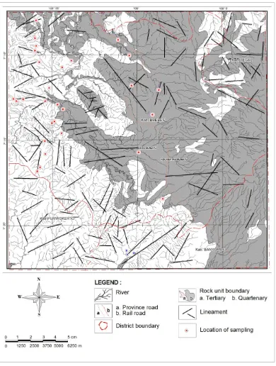
Lineament and River-segment
6
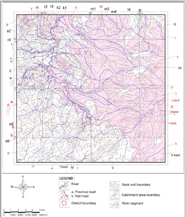
Figure 2. Lineaments being parallel to river segments are drawn to represent their populations both in Tertiary marine sediments and Quaternary volcanic deposits in
taken in Pemali river basin. In southwestern side this main river and its tributaries flow on Tertiary marine sedimentary rock formations, known as Halang and Kumbang Formation. That is why, lineaments and river segments in these formations were taken as samples representing deformation pattern generated in Tertiary sediments. On the other hand in northeastern side the river and its tributaries flow on the Quaternary volcanic deposits, in which the samples of those existing variables were also taken (Figure 2).
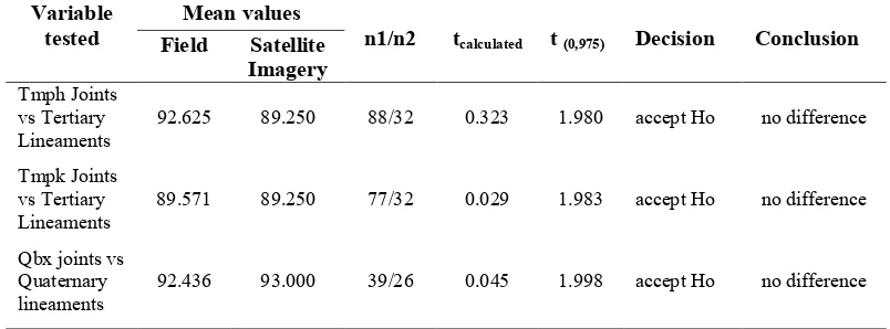
Both respective pair samples from Tertiary- and Quaternary systems were only able to be obtained from Satellite Imagery interpretation, because both the very long river segments and the lineaments can not be observed in the field. But, samples of joints representing the deformation pattern were obtained from the field and they are used to check if the samples of lineaments are valid and reliable by using t-tests. For testing this validity and reliability, the result of tests in Table 1 are not significant difference, which suggest that the samples of lineaments are
able to be used for the next verification purposes in this research.
The result of tests in Table 1 also shows that means of samples of joints obtained from Halang and Kumbang Formations are not significant difference, suggesting that they represent the same deformation pattern in the Tertiary marine sedimentary rocks in the researched area.
RESULT AND DISCUSSION
Relationship of River-segment and
Lineament
The result of regression-correlation analysis indicates a significant relationship between the two above-mentioned variables. The result of the regression-correlation analysis verifies how close is the relation between river-segment pattern and lineament pattern for the tributaries of Pemali River on the Quaternary volcanic deposits. The linier regression formula constructed from the
Tabel 1. Result of tests of difference between two means of obtained joints
a) Joint samples from field vs lineament samples from satellite imagery interpretation on Tertiary sediments and Quaternary volcanic deposits (Qbx)
Variable tested
Mean values
n1/n2
tcalculated t (0,975) Decision Conclusion Field Satellite
b) Joint samples from Halang Formation (Tmph) vs Kumbang Formation (Tmpk)
Tmpk joints vs Tmph joints
8
Figure 3. Scattered diagram exhibiting significant relationship between river segments (Y) and lineaments (X) in Quaternary volcanic deposits
analysis is Y = -1.227 + 0.988 X, and the large coefficient of correlation r is 0.999 (Figure 3). This analysis suggests that river segment development on Quaternary deposits is governed by deformation pattern of the rock unit due to recent active tectonism.
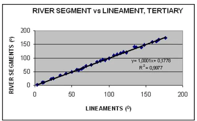
The result of analysis for the tributaries of Pemali River on Tertiary sediments also indicates the same phenomenon. The constructed linier formula is Y = 0,178 + 1.000 X, and the large coefficient of correlation r is 0.998 (Figure 4, also Table 2). The diagrams in Figure 3 and 4 show that the straight lines indicate the constants of proportion of nearly 1. The lines clearly explain that every plotted point on the diagrams represents the almost same value of the lineament and the river-segment azimuths on X-axis and Y-X-axis respectively.
The result of t-tests in Table 3 shows that means of river segments and lineaments in Quaternary volcanic deposits is different, on the contrary in Tertiary sediments the means of these variables is not different. It suggests that
river segments in the Quaternary deposits has been developing into different flow direction compared with the azimuths of existing lineament, meaning that the erodibility of the deposits is so high. This phenomenon is shown
Table 2. Result of regression-correlation analyses between river segment and lineament azimuths both in Quaternary volcanic deposits and Tertiary marine sediments.
Rocks n r R2 Tcalculated t(0.01) Decision Conclusion
Quaternary 26 0,999 0,998 115,3921 2,7969 reject Ho strong relation
Tertiary 32 0,998 0,997 109,8253 2,7500 reject Ho strong relation
Table 3. Result of tests of difference between two means of azimuths of river segment and lineaments in both Quaternary deposit and Tertiary sediments.
Formation tested
Mean values
n1/n2 tcalculated t (0,975)
Decision Conclusion River
segment
Lineament
Quaternary deposits
91,808 93.000 26/26 -2,551 2,064 reject Ho different
Tertiary sediments
89,437 89,250 32/32 0,442 2,042 accept Ho no difference
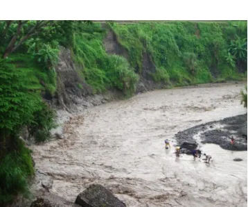
Figure 5. Keruh River in Bumiayu showing flow of concentrated mud waterfrom highly erodibility of volcanic deposits in upstream area due to deformation by neotectonic
10
by muddy rivers rich in concentrated suspended networks prepared from topographic map obtained from Digital Elevation Model Map. The numbers of the samples from the respective sub-basins on the Tertiary sediments and Quaternary volcanic deposits are 25 and 16 (Figure 6).
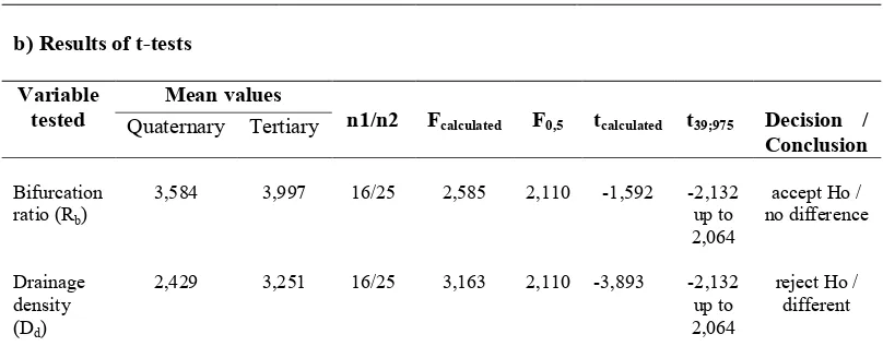
Drainage density Dd is ratio of the total length of all rivers within a drainage basin L to the area of that basin A and Dd = L/A. Bifurcation ratio confirm the morphological development of sub-basins on the Quaternary deposits as a result of active tectonism. The result of this simultaneous difference test between the mean values of Rb and Dd representing sub-basins on Tertiary sediments on one side and those variables means from the sub-basins on Quaternary deposits on the other side is significant. This test needs further information about which variable mean is different (Table 4b).
The last result of the test suggests that the morphometry of the subbasins, developing on the Quaternary volcanic deposits, is the same with that on Tertiary sediments which is affected by the recent active tectonism shown by no significant difference of Rb means. But, the conclusion about the active tectonism generating the different density between recent deformation patterns of Quaternary and Tertiary rock units is verified by the test that is presented by the different Dd means (Table 4b).
Table 4. Test of difference between vector means of Rb and Dd in Quaternary deposits and Tertiary sediments
a) Result of T2-Hoteling test
Population T2-Hoteling T2(0.05,2,39) Decision / Conclusion
Quaternary deposits vs Tertiary sediments
13,8675 6,642 reject Ho / different
12
CONCLUSION AND
RECOMMENDATION
The results of this research suggests that the Quaternary tectonism is active. This neotectonic activity is manifested by frequent shallow earthquakes, enables the present author to measure its effect through the similarity of tectonic morphometry development of river basins on Quaternary to Tertiary deposits. This phenomenon is the continuation of the former post Tertiary tectonic period generating deformation pattern in Quaternary volcanic deposits which is similar to the Tertiary marine sediments deformation. Therefore, this phenomenon is considered as a measure of recent tectonic activity or neotectonism. The neotectonism controls the development Pemali river basins morphometry in the area of Quaternary volcanic product distribution of Slamet volcano. The tectonic geomorphology being characterized by the morphometry of the river basin development in this area is significantly responding the neotectonism. Existing geological hazards in this area due to the active tectonism should be taken into University, Head and Secretary of Research Institute, and also to Research Consideration Committee (KPP), for funds and supports that enable him and his team to undertake and finish the research in Bumiayu, from which this paper is possibly written. The author is also very grateful to editor in chief of Journal of Research, Geology, and Mining, Research Center for Geotechnology (Majalah Riset, Geologi & Pertambangan, Puslit Geoteknologi, Lembaga Ilmu Pengetahuan Indonesia) Dr. Robert M. Delinom, and also Mr. Sudaryanto, Ir. M.Si, for publishing this paper.
REFERENCES
Bates, L.B. & Jackson, J.A., 1984. Dictionary of Geological Terms. The American Geological Institute, Anchor Book Doubleday, New York, 571 p.
Budiadi, 2008. Role of tectonism in the development of Kulon Progo mountainous region, Yogyakarta,.PhD Thesis, Padjadjaran University, unpublished. *)
Djuri, M., Samodra, H., Min, T.C., & Gafoer, S, 1996. Geological Map of Purwokerto and Tegal Sheet, Java, scale 1:100.000. Geological Research and Development Centre. *)
Doornkamp, J.E., 1986, Geomorphological approach to the study of neotectonics. Jour. Geol. Soc. London 143: 335-342.
Hirnawan, F., 1987. The effect of reverse fault on patterns of strike and dip of bedding planes and joints in Halang Formation, Bantarujeg, Regency of Kuningan, West Java. Jurnal Riset Geologi & Pertambangan, Puslit Geoteknologi, pp. 31-40.*)
Hirnawan, F., 1997. Morphometry
characteristics of drainage system in the region of active tectonic effects – Case study of Cijolang and Cimuntur Drainage System).
Analisis Sistem, BPPT (Technology Evaluation and Application Board), Kedeputian Bidang Analisis Sistem, No. 9, IV: 67-77.*)
Hirnawan, F., Sudarsono, U., & Soehaimi, A, 1998. Tracing landslide hazards zonation of slope stability dynamic system and the stabilization by optimizing the integrated role of vegetation and slope-geometry, State Ministry Office of Research & Technology, National Research Council, Research Report of Riset Unggulan Terpadu Program (Integrated Research Program), Field of Environment Protection-Technology, 141 p.*)
Hirnawan, F., Agus Nur, A., Sophian, I., 2007.
Response of Quaternary morphometry to active tectonism as area constraint for spatial and infrastructure development program, Bumiayu, Central Java, Research Institute, Padjadjaran University.*)
Kastowo & Suwarna, 1996. Geological Map of
Majenang Sheet, Java, scale 1:100.000,
Geological Research and Development Centre Keller, E.A., & Pinter, N., 1999. Active
tectonism. New York: Prentice Hall Inc., 337p. McNeil, L., 1999, Illustrated Dictionary of Earth Science, the American Geological Institute, Tasa Graphic Arts, Inc.
Nakata, T., Odaka, J., Goto, H., Asahi, K., Chida, N., Suzuki, Y., Watanabe, K., & Nakamura, T. 1996. A trench study on the surface fault
rupture in Awaji Island associated with the
1995 Hyokogen-nambu earthquake, Jour.
Active Fault Res. 14: 23-27.
Simandjuntak, T.O., 1980. Sediment gravity flow deposits in Pangandaran Region, Southwest Java and their bearing on the tectonic development of Southwestern Indonesia, Bull. Res. and Dev. Center 2: 21-54.
Splitz, W.J., & Schumm, S.A., 1997. Tectonic geomorphology of Mississippi Valley between
Osceola, Arkansas and Friars Point,
Mississippi. Eng. Geology 46: 259-280. Stewart, I.S., & Hancock, P.L., 1994.
Neotectonics, in: P.L. Hancock (Editor). Continental Deformation. Pergamon Press, 370-404.