Short communication UDC 550.834
Importance of data and process management
in Eurocode 7 – based design
Leo Mate{i}1, Predrag Kvasni~ka2and Snje`ana Mihali}2
1Faculty of Civil Engineering University of Rijeka and Geokon-Zagreb d.d., Croatia
2Faculty of Mining, Geology and Petroleum Engineering University of Zagreb, Zagreb, Croatia Received 1 March 2011, in final form 17 April 2011
This paper describes how a geotechnical database may be generated from the information system (IS) of a geotechnical consulting company established in compliance with the ISO 9001, ISO 17025 QMS standards and Eurocode 7. The application of these principles is illustrated using a geotechnical consulting company Geokon of Zagreb, Croatia as an example. An overview of Geokon’s geotechnical data management system is presented by describing the proce-dures for data input, maintenance, use, expansion and upgrade. Included in this paper are relevant flow charts and a hierarchy of both geotechnical data-bases and other datadata-bases.
Keywords: data management, document flow, geotechnical database, ISO 9001, ISO 17025, Eurocode 7
1. Introduction
Geotechnical engineering (geotechnics) is in many ways a special branch of civil engineering because geotechnical design processes and technical solu-tions depend mostly on local soil condisolu-tions. It should be recognized that the understanding of soil conditions depends on the extent and quality of the geotechnical investigations. Such understanding and the control of workman-ship are usually more significant in fulfilling fundamental design require-ments than is precision in the calculation of models and the implementation of partial safety factors. In addition to calculations, geotechnical design is often based on the so-called “comparable experience”. The comparable experience is also recognized by Eurocode 7 (EC7), where it is defined as documented or other clearly established information related to the consideration of the ground in design, which involves the same types of soil and rock as well as other simi-lar structures for which simisimi-lar geotechnical behavior is expected. However, EC7 does not explain the true meaning of “documented and clearly estab-lished information”.
When geotechnical design is based on engineering calculations, some of the most important design considerations are geotechnical parameters. How does EC7 address them? When establishing the values of geotechnical parame-ters, the following should be considered: published and well-recognized infor-mation relevant to the use of each type of test in the appropriate ground condi-tions. What is well-recognized information? EC7 states that the evaluation of geotechnical information should include (if appropriate) a review of the field and laboratory work. Any limitation in the data shall be pointed out and com-mented upon. Sampling and sample transportation and storage procedures shall be considered when interpreting the results. Any particularly adverse test results shall be considered carefully to determine if they are misleading or represent a real phenomenon that should be accounted for in the design. The evaluation of geotechnical data should include the tabulation and graphical presentation of the results of field and laboratory work. The provisions of EC7 are based on the assumptions that the data required for design be collected, recorded and interpreted by appropriately qualified personnel and that ade-quate continuity and communication exist between the personnel involved in data collection, design and construction. Adequate supervision and quality control are provided in factories, in plants and on site. Execution occurs ac-cording to the relevant standards and specifications by personnel with the ap-propriate skills and experience. Construction material and products are used as specified by this standard or by relevant product specifications.
EC7 also states that geotechnical information should always be carefully collected, recorded and interpreted. This information shall include the geol-ogy, geomorpholgeol-ogy, seismicity, hydrology and history of a site. The scope of geotechnical investigations shall be continuously reviewed as new information is obtained during the execution of a given project. The characteristics and ba-sic constituents of the soil or rock involved shall be identified before the re-sults of other tests are interpreted. Soils should be classified and soil layers should be described according to an established geotechnical soil classification system. In addition to visual observation, several tests for the classification of soil and the evaluation of material parameters of soils and rocks may be used. Routine field investigations and laboratory testing shall be conducted and re-ported in accordance with internationally recognized standards and recom-mendations. It is imperative that all types of data are collected continuously and that during this process, internationally recognized standards are fol-lowed.
Finally, EC7 states that the results of a geotechnical investigation shall be compiled in a Ground Investigation Report, which shall form a part of the Geotechnical Design Report. This report should normally consist of a presen-tation of all available geotechnical information, including geological features and relevant data, and a geotechnical evaluation of the information that states the assumptions made in the interpretation of the results. In the evaluation of geotechnical information, any test result that does not meet the specifications
should be carefully reviewed to determine whether the results are misleading or represent a site condition that should be considered in the design.
Geotechnical data can be grouped into three types: structure and ground data, structure-ground interaction data and ground data generated during monitoring. Data can be managed and interpreted more easily if they are stored in electronic form and organized as a database. For such a database, the defined procedures of data input, maintenance, and use are required. One of the proposals used to set up the geographical information system for boring geotechnical logs of the Zagreb area has already been presented by Kvasni~ka et al. (1997), Kvasni~ka and Mate{i} (2001) and Mate{i} and Kvasni~ka (2007). In these papers, a special emphasis is placed on the collection, organization, critical evaluation, input and subsequent digitalization of the boring log data.
Ground data are obtained during field and laboratory investigations that are conducted by specialized sub-contractors who are selected during a com-petitive bidding process. A sub-contractor’s performance depends largely on the manner in which the work is organized and managed. In that respect, the application of the ISO 9001 standard that sets the basic requirements for the quality management systems (QMSs) can prove extremely helpful. In addi-tion, EC7 requires that previous relevant experience and knowledge of ground and structures be used in a design process in such a manner that the next step can begin only after the evaluation of the information collected in the previous step has been completed (e.g., when determining geotechnical parameters – Section 3: Geotechnical data). The requirements of EC7 mentioned above can only be satisfied through a well-designed management process supported by well-organized databases. This paper describes how a geotechnical database can be generated from the information system (IS) of a geotechnical organiza-tion in compliance with the ISO 9001, ISO 17025 QMS standards and EC7. The application of these principles is illustrated through the example of the consulting firm Geokon from Zagreb, Croatia.
2. Process analysis
For geotechnical firms that are not organized based on the standards men-tioned above, the introduction and application of these standards is a costly and years-long process whose success is directly dependent on the continuing commitment of all employees to achieve this objective. The organization of such a workforce in compliance with the above ISO standards, fundamental business activities and processes should be analyzed, and the code-mandated procedures for quality control/quality assurance should be established.
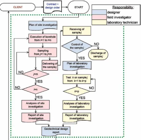
The process of completing a ground investigation report is outlined in Fig-ure 1. The process includes a series of interconnected activities that are per-formed by several people. According to ISO 9001, the process should be docu-mented by completing appropriate forms; such forms may contain ground data
(e.g., borehole location, sampling depth, etc.) entered only by the person re-sponsible for such data. The basic principle of designing a geotechnical data-base is that the data are entered at the moment of their generation, at their place of origin and by the person who generates the data. Such a process can be called “taking water from the well” (or “the acquisition of data at source”), which is beneficial because any delayed data collection is subjected to a possible “contamination” due to recollection. Furthermore, the data entered immedi-ately after the generation are readily available and can be used in the calcula-tion and evaluacalcula-tion of other data that are required in the next step of the pro-cess (e.g., sampling depths enables the calculation ofin situstress). With the consistent application of such a basic principle, a ground investigation report itself becomes a set of ground data that are collected concurrently with geo-technical investigations and laboratory tests.
The documentation of a process serves as a data quality assurance log. Thus, if an error occurs (e.g., incorrect borehole location or sampling depth) in a
documented process, such an error is readily identified and corrected. In addi-tion, such a process should be used to detect the source of the error to reduce or completely eliminate the possibility of its recurrence. The source of the error can be detected by “rewinding” the process. The necessary condition required to reconstruct the process is that it is documented and recorded by a chain-of-cus-tody procedure, such as when the person responsible for the field work delivers a specimen to a laboratory and the person responsible for the laboratory testing signs and dates a form that acknowledges that he/she received a sample.
Recording is illustrated using Geokon, a geotechnical consulting company that is located in Zagreb, Croatia, as an example. Their IS is structured and au-tomated so that documented orders are started, maintained and closed ( docu-ment flow) according to the matrix of responsibilities and authorities. Docu-ments that show the time schedules, working lists, etc. are defined by the person who is responsible for them, and the data entered into the documents are processed by a computer immediately upon their entry. For a geotechnical database, by using an IS, the geotechnical product data (i.e., documents such as geotechnical reports, designs and monitoring reports) are also generated. These documents contain data on soil (results of site investigations and laboratory testing) and structures (designs and monitoring). Moreover, these data are space-related, and the storing of their coordinates in a database allows them to be displayed using maps (using GIS tools). Due to the basic business activities that include site investigations, laboratory testing, design, supervision, and monitoring in geotechnics, the organization described above is used as a repre-sentative example of providers and users of geotechnical data who operate within the same organization.
The majority of geotechnical data are the result of site investigations and laboratory tests. For this reason, the preparation of site investigation pro-grams has been fully developed by including the specification of the locations and labels of boreholes and samples as well as the preparation of the labora-tory testing plan for the samples included in the program. The value of the data in the geotechnical database also depends on the testing quality, which is well documented. Thus, the method, sample, researcher and equipment data for every test are entered in the Geokon database, satisfying the ISO 17025 re-quirements. This enables subsequent analyses to indicate, if necessary, the source and size of an error, which is important in measuring uncertainty.
3. Schematic representation of the IS and database
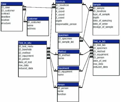
The schematic representation of a database referring to ground data is il-lustrated in Figure 2. For a simplified more clear presentation of the structure of a database, the schematic representation does not include all of the tables and data stored in particular tables but only includes those that show the links between tests and customers. Such links allow all of the persons who are
in-volved in the process of completing a ground investigation report – from the managing director to the designer to the laboratory technician – to manage their activities and tasks that result from such activities. The IS is called »Dabar-Explorer» and is programmed to accomplish the following goals:
– to enable the performer to allocate tasks during an activity to several persons,
– to enable the supervision of the tasks being performed and
– to allow the performer, prior to closing the task form, to receive all sub-orders and enter all of the required data (including ground data among other items).
For geotechnical ground data, the status of the crucial elements of the da-tabase is monitored. These elements include the following: “CASE”, “bore-hole”, “sampling”, and “testing”. The defined statuses are open (planned) and closed (completed and cancelled). The possibility of opening and closing partic-ular elements of the database is defined by their interrelationship, i.e., hierar-chy. Thus, the work involved in creating a ground investigation report (first step: setting up a program of field and laboratory investigation) can begin only after the “case” has been opened. When setting up the field and laboratory
vestigation program, the “borehole” must first be opened, and “sampling” and “testing” can only be defined after that opening. Additionally, the IS is de-signed/developed so that the investigation work cannot be started before the method, manpower, and equipment data are retrieved from the database. In this way, is the following are ensured:
– suitable methods, which can also be defined by standards, are employed, – the particular laboratory technician who is trained and certified to con-duct the tests using the selected method, is assigned and
– the tests are performed on serviceable and calibrated equipment. The “boreholes” can be closed only after all open “sampling” and “testing” have been closed, whereas the “case” can be closed only after all “boreholes” have been closed.
4. Unique mark
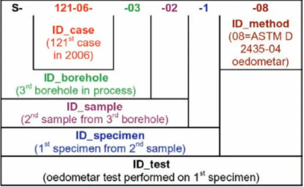
In developing an IS, the establishment of a code system to determine unique marks (ID) for the separate elements of the database is crucial. Figure 3 presents an example of the way in which the unique mark of laboratory test-ing is generated. The mark is formed generically and logically, which enables the following:
– a simple algorithm for its programming, – easy memorization and
– the simple input of queries into both the database and the archives in which hardcopy documents are stored.
For example, when a field investigator is charged with a task, he/she re-ceives labels with pre-printed sample marks to label the samples as soon as they are obtained from a borehole.
Such a code system makes the database transparent, open and user-friend-ly, which are the required characteristics for its integration into other data-bases.
5. Legal conditions regarding the use of geotechnical data
The principles outlined in this paper are intended to enable geotechnical companies to acquire, process and present geotechnical data in an economical, yet highly professional manner. Adherence to these principles further allows for the dissemination of geotechnical data to the scientific, administrative and commercial communities.
Once published in scientific papers and included in databases, the data be-come available to global scientific and engineering communities and are gener-ally free of charge.
EC7 promotes “comparable experience” in design. It is therefore expected that countries that intend to accept Eurocodes as national standards should regulate at the state level to ensure that the data from geotechnical reports be treated as “public property”, such as meteorological, environmental pollution and public health data. The same standards should apply for previous geo-technical data and other similar (geological, hydrogeological, etc.) data.
Temporarily, the problem may be solved by regulating the status of data in contracts with contractors and the execution of various public works.
6. Conclusions and recommendations
The provisions of EC7 are based on the assumptions that the data re-quired for design are collected, recorded and interpreted by appropriately qualified personnel and that adequate continuity and communication exist be-tween the personnel involved in data collection, design and construction. A geotechnical database can be generated from the information system (IS) of a geotechnical organization in compliance with the ISO 9001, ISO 17025 QMS standards and EC7.
In this paper, attention is drawn to the following important results: – the introduction, maintenance and upgrade of an IS must take place without interruptions in production; the implemented IS should be accepted by employees as a useful tool,
– geotechnical data should be immediately entered into the database at their place of origin and
– the transparency of an IS enables communication with an external IS. It would be beneficial for the entire geotechnical community to organize other parties (providers and users) who are interested in geotechnical data-bases and to establish direct communication among them.
Additionally, it is necessary to initiate legal regulation of the status of geotechnical data as public property.
References
British standard: Eurocode 7: Geotechnical design – Part 1: General rules, BS EN 1997-1:2004. ISO 9001: 2000 Quality management systems – Requirements.
ISO/IEC 17025: 2005 General requirements for the competence of testing and calibration labora-tories.
Kvasni~ka, P., Mate{i}, L. and Skra~i}, S. (1998): Geotehni~ka podloga Grada Zagreba, Gra|e-vinar,50, 119–127. (in Croatian)
Kvasnicka, P. and Matesic, L. (2001): Geotechnical data base for the City of Zagreb and its appli-cation in site response analysis,Fourth International Conference on Recent Advances in Geo-technical Earthquake Engineering and Soil Dynamics, San Diego, CA, Paper No. 11.15, 1–8. Mate{i}, L. and Kvasni~ka, P. (2007): Geotechnical data management according to ISO 9001, in
Proceedings of the 14thEuropean Conference on Soil Mechanics and Geotechnical Engineering,
Madrid, Spain,3, 1715–1719.
SA@ETAK
Va`nost podataka i upravljanja procesima u projektiranju temeljenom na Eurokodu 7
Leo Mate{i}, Predrag Kvasni~ka i Snje`ana Mihali}
U radu se opisuje na koji na~in se geotehni~ka baza podataka mo`e stvarati kroz informacijski sustav (IS) geotehni~ke organizacije u skladu sa zahtjevima upravljanja kvalitetom standarda ISO 9001, ISO 17025 i propisa Eurocode 7. Primjena tih na~ela prikazana je na primjeru tvrtke Geokon-Zagreb d.d. Pregled upravljanja geotehni~kim podacima dan je kroz opis unosa podataka, te njihove obrade, kori{tenja, dodavanja i nadogradnje. Uz ostalo dani su grafi~ki prikazi dijagrama toka i me|uodnosa geo-tehni~ke baze podataka i drugih baza podataka.
Klju~ne rije~i:upravljanje bazama podataka, tok dokumenta, geotehni~ka baza
poda-taka, ISO 9001, ISO 17025, Eurokod 7