REGISTRATION OF OPTICAL AND SAR SATELLITE IMAGES BASED ON
GEOMETRIC FEATURE TEMPLATES
N. Merkle∗, R. M¨uller, P. Reinartz
German Aerospace Center (DLR), Remote Sensing Technology Institute, Oberpfaffenhofen, 82234 Weßling, Germany - (nina.merkle, rupert.mueller, peter.reinartz)@dlr.de
Commission I, WG I/4
KEY WORDS:Registration, Multisensor, SAR, Optical, Matching, Multispectral, Image
ABSTRACT:
Image registration is required for different remote sensing applications, like change detection or image fusion. Since research studies have shown the outstanding absolute geometric accuracy of high resolution radar satellites images like TerraSAR-X, the importance of SAR images as source for geolocation enhancement has increased. Due to this fact, multi-sensor image to image registration of optical and SAR images can be used for the improvement of the absolute geometric processing and accuracy of optical images with TerraSAR-X as reference. In comparison to the common optical and SAR image registration methods the proposed method is a combination of intensity-based and feature-based approaches. The proposed method avoids the direct and often difficult detection of features from the SAR images. SAR-like templates are generated from features detected from the optical image. These templates are used for an intensity-based matching with the SAR image. The results of the matching process are ground control points, which are used for the estimation of translation parameters followed by a subpixel translation of the optical image. The proposed image registration method is tested for two pairs of TerraSAR-X and QuickBird images and one pair of TerraSAR-X and WorldView-2images of a suburban area. The results show that with the proposed method the geometric accuracy of optical images can be enhanced.
1. INTRODUCTION
Image registration is an on-going research topic and required for different applications in remote sensing, like change detection or image fusion. Since research studies have shown the outstanding absolute geometric accuracy of high resolution radar satellite im-ages like TerraSAR-X (Ager and Bresnahan, 2009), the impact of SAR images as source for geolocation enhancement, especially for image registration, has increased. Multisensor image to im-age registration is still a challenging task especially in the case of optical and SAR images. Core differences in the sensor geome-try and radiomegeome-try of the optical and SAR sensors are challenging for the registration of the images acquired by such sensors.
An important application of optical and SAR image registration is presented in the work of Reinartz et al. (2011) and Perko et al. (2011). In these papers, the absolute geometric processing and accuracy of optical images are improved by using ground control points (GCPs) selected from high resolution TerraSAR-X reference images. These papers show how the precision of high resolution SAR images can be used to improve the geometric accuracy of optical satellite data.
A variety of different image registration approaches were de-veloped over the last years. The most common registration ap-proaches can be classified in two categories. The first category are intensity-based registration approaches. For instance, mu-tual information is a widely used intensity-based registration ap-proach and investigated in different papers like Chen et al. (2003) and Suri and Reinartz (2010). Further intensity-based registration methods are using the cross-cumulative residual entropy (Hasan et al., 2012) or the normalized cross-correlation coefficient (Shi et al., 2012). The second category are feature-based registra-tion approaches, which are commonly based on the detecregistra-tion and
∗Corresponding author. Email: [email protected].
matching of features like points (Fan et al., 2013), lines (Pan et al. (2008), Huang et al. (2010), Haigang et al. (2015)) or regions (Dare and Dowman, 2001) within the image.
The above described methods for optical and SAR image regis-tration have several drawbacks. Intensity-based regisregis-tration ap-proaches like mutual information often fail because of the differ-ent radiometric and geometric properties of the SAR and optical images. The paper of Zhao et al. (2014) shows that reliable re-sults are only achieved for image pairs with small misalignment. A problem of feature-based approaches is the feature detection from the SAR image due to speckle noise and geometric radar ef-fects. Therefore, the quality of the detected features shows strong influence on the results of these registration methods. Neverthe-less, over the last years feature-based approaches are proven to be more suitable for the problem of multisensor image registration than intensity-based methods.
2. METHOD
The proposed method for the registration of optical and SAR im-ages consists of four steps: (1) feature detection and extraction, (2) feature matching, (3) transformation model estimation and (4) image resampling and transformation (Zitov´a and Flusser, 2003). The whole image registration chain is illustrated in Figure 1 and detailed in the remainder of Section 2.
Figure 1: Overview of the proposed method.
2.1 Feature Detection and Extraction
In the first step of the image registration chain, spatial features (roundabouts) are detected and extracted from the image. Since the direct detection of features from the SAR images is often diffi-cult, the features are only detected and extracted from the optical image. OpenStreetMap data is used to find the rough location of roundabouts in the optical image.
The edge detection plays a crucial role in the further process. Therefore, it is important to highlight the differences between the street and the vegetation around the street or inside the central island of the roundabout. Therefore, the normalized difference vegetation index (NDVI) image is generated and used for edge detection. The edge image in an area around each roundabout is computed with a zero crossing edge detection method (Linde-berg, 1998). In the end, a circle fitting method is used to detect the boundary and the center of the central island of each round-about. Figure 2 shows the NDVI image of a roundabout and the corresponding edge image, where the detected boundary of the central island is highlighted in red.
2.2 Feature Matching
In the second step, the extracted roundabout geometry from the optical image is used for a template based matching with the SAR image. Therefore, the extracted roundabout information, i.e. cen-ter position and radius of the central island, are used to generate SAR templates for all roundabouts. Figure 3 illustrates the com-parison between the extracted roundabout from the optical image
(a) (b)
Figure 2: The NDVI image of a roundabout from the optical im-age (a) and the detected circle superimposed on the detected edge image (b).
(a), the generated template (b) and the roundabout appearance in the SAR image (c).
(a) (b) (c)
Figure 3: A roundabout in the optical image (a), the generated roundabout template (b) and the same roundabout in the SAR image (c).
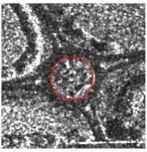
The generated roundabout templates are then used for an intensity-based matching with the SAR image. From this procedure the center positions of the roundabouts from the SAR image are ob-tained. Figure 4 shows an example of a roundabout in the SAR image, where the derived center position is marked in red.
For a more detailed insight into the used circle fitting method, the template generation and the intensity-based matching see our previous work (Merkle et al., 2015) and the work of Wu et al. (2008).
Figure 4: The roundabout in the SAR image and the extracted circle (red) and center position (red+) after the matching process.
2.3 Transformation Model Estimation
For estimating the translation parameters, the distance between the GCPs detected from the SAR image and the roundabout cen-ters detected from the optical image inx- andy-direction is cal-culated (thex-direction corresponds to east and they-direction to north). Afterwards, the mean values of the distances in both directions are calculated and used as translation parameters.
2.4 Image Resampling and Transformation
In the last step of the image registration chain, the estimated translation parameters are used to translate the optical image, and thus, to improve the geometric accuracy of the optical image. Bi-linear interpolation is used to resample the optical image after the subpixel image translation.
3. EXPERIMENTS 3.1 Data Description
The experimental data set consists of TerraSAR-X, WorldView-2and QuickBird imagery acquired over Oberpfaffenhofen, Ger-many (see Table 1). The WorldView-2and the QuickBird images are orthorectified using the Shuttle Radar Topography Mission (SRTM) DEM. The spatial resolution is0.5m for the TerraSAR-X image,2m for the WorldView-2image and2.4m for the Quick-Bird image. To cover all roundabouts in the TerraSAR-X scene one WorldView-2and two QuickBird images are required.
TerraSAR-X QuickBird WorldView-2
Table 1: Details of TerraSAR-X, QuickBird and WorldView-2 images.
A reference dataset is used for the evaluation of the results. The dataset consists of reference points, which have been measured with a Leica GPS1200and an absolute geometric accuracy in the range of30cm. For every roundabout in the scene11to16 refer-ence points have been measured at the boundary of each central island. The coordinates of all roundabout centers are calculated with an ellipse fitting method (Gander et al., 1994) from the ref-erence points, which are located on the boundary of the central island. This points are needed to evaluate the geometric accuracy of the translated images at the center of each roundabout. More-over, 6further reference points (street crossings) are measured to evaluate the geometric accuracy of the translated images apart from the roundabouts.
3.2 Results and Discussion
The image registration chain described in Section 2. is tested on two pairs of QuickBird and TerraSAR-X and one pair of WorldView-2and TerraSAR-X images of a suburban area. The whole scene covered by the images contains five roundabouts with radii between7.3m and24.9m. Three of the roundabouts
are contained in the QuickBird image acquired on 24.09.2011 (denoted by QuickBird image1) and two of the roundabouts are contained in the QuickBird image acquired on 24.10.2011 (de-noted by QuickBird image2).
The center and radius of each roundabout are detected in all opti-cal images by applying the method explained in 2.1. Afterwards, SAR like templates are generated and used for the intensity-based matching with the TerraSAR-X image, as described in 2.2. The result of the matching process are the circle center positions of all roundabouts in the TerraSAR-X image. These circle center positions are the GCPs, which are required for the estimation of the translation parameters.
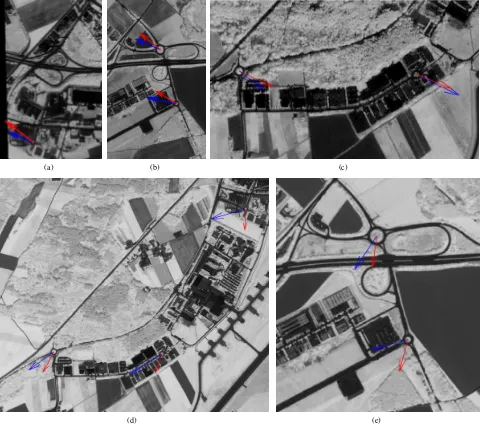
In order to determine the translation parameters, the distance be-tween every GCP and the detected roundabout center from the optical image inx- andy-direction is calculated. Figure 5 shows the image scenes, which contain the roundabouts of the Quick-Bird images and the WorldView-2image. The image scenes in Figure 5(a) and (b) show a subset of the QuickBird image1, the image scene in Figure 5(c) shows a subset of the QuickBird im-age2and the image scenes in Figure 5(d) and (e) show a subset of the WorldView-2image. The blue vectors are pointing from the roundabout center, detected from the optical image, to the corre-sponding GCP. In comparison, the red vectors are pointing from the roundabout center detected from the optical image, to the cor-responding roundabout center from the reference data. For an simplified visualization, all vectors in Figure 5 (a)-(c) are scaled by a factor of25and in Figure 5(d) and (e) by a factor of50.
Each red and blue vector pair in Figure 5 (a)-(c) is pointing ap-proximately in the same direction and has almost the some length. Moreover, the different vector pairs within each QuickBird image have very similar directions and lengths. An improvement of the geometric accuracy of the QuickBird images is assumed if each QuickBird images is shifted towards the average direction of the corresponding blue vectors. In comparison, in Figure 5 (d) and (e) the red and blue vectors differ in their length and direction within each vector pair and within the whole WorldView-2 im-age. By shifting the WorldView-2image in the average direction of the blue vectors, the geometric accuracy is improved for some points but not for the whole image. A possible reason is that the geometric accuracy of the TerraSAR-X image is not signif-icantly higher than the geometric accuracy of the WorldView-2 image. Therefore, further results are only shown for the case of TerraSAR-X and QuickBird image pairs.
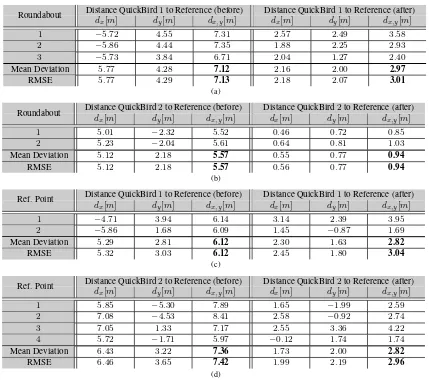
For estimating the translation parameters the mean value of the distances inx- andy-direction between the GCPs and the round-about centers from the optical images are calculated. In particu-lar, the QuickBird image1is translated by6.65m inx- and by −2.16m iny-direction and the QuickBird image2by−4.98m in
x- and by2.88m iny-direction. After translating both QuickBird images, the geometric accuracy improvement can be evaluated. Table 2(a) and (b) show the distance inx- andy-direction and the Euclidean distance between the detected roundabout centers of the QuickBird images and the reference dataset. Furthermore, the mean deviation and the root mean square error (RMSE) is calculated. In contrast, Table 2(c) and (d) shows the distances be-tween reference points detected from the QuickBird images and from the reference dataset, together with the mean deviation and the RMSE.
(a) (b) (c)
(d) (e)
Figure 5: Illustration of the distance between the GCPs and the roundabout centers detected from the optical images (red vectors) and the distance between the detected roundabout center from the optical image to the roundabout center from the reference data (blue vectors). Figure (a), (b) and (c) show a subset of the QuickBird images (NDVI) and the vectors are scaled by a factor of25. Figure (d) and (e) show a subset to the WorldView-2image (NDVI) and the vectors are scaled by a factor of50.
case of the QuickBird image2. Although a simple subpixel trans-lation is applied on both QuickBird images, the improvement of the accuracy is also measured at the reference points apart from the roundabouts. In the QuickBird image1the geometric accu-racy of the two reference points is enhanced from2.55to1.18 pixel and the geometric accuracy of the four reference points in QuickBird image2is enhanced from3.09to1.18pixel.
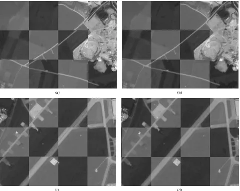
An illustration of the impact on both QuickBird images related to the translation can be seen in Figure 6. The Figure shows chess-board overlays of two overlap areas of the two QuickBird im-ages. Figure 6(a) and (c) are examples of the overlap areas before the image translation and (b) and (d) after the image translation. The darker patches correspond to the QuickBird image1and the brighter patches to the QuickBird image2.
The chessboard overlays in Figure 6 confirm that with the pro-posed image registration chain also the alignment of both Quick-Bird images to each other is improved. In both example scenes a substantial improvement of the alignment of both images can be clearly distinguished.
4. CONCLUSION AND FUTURE WORK In this paper a new approach for image registration of optical and SAR satellite images is presented. By combining classi-cal feature-based and intensity-based approaches the proposed method avoids the drawbacks of them. Due to speckle noise and geometric radar effects, the direct detection of features from SAR images for feature-based approaches is often difficult. Therefore, the proposed method detects features only from the optical image. Intensity-based approaches are suffering from the differences in the sensor geometry and radiometry between the two sensor. Due to this, our method generates SAR-like templates from detected edges, and uses them for an intensity-based matching with the SAR image.
Distance QuickBird1to Reference (before) Distance QuickBird1to Reference (after) Roundabout
dx[m] dy[m] dx,y[m] dx[m] dy[m] dx,y[m]
1 −5.72 4.55 7.31 2.57 2.49 3.58
2 −5.86 4.44 7.35 1.88 2.25 2.93
3 −5.73 3.84 6.71 2.04 1.27 2.40
Mean Deviation 5.77 4.28 7.12 2.16 2.00 2.97
RMSE 5.77 4.29 7.13 2.18 2.07 3.01
(a)
Distance QuickBird2to Reference (before) Distance QuickBird2to Reference (after) Roundabout
dx[m] dy[m] dx,y[m] dx[m] dy[m] dx,y[m]
1 5.01 −2.32 5.52 0.46 0.72 0.85
2 5.23 −2.04 5.61 0.64 0.81 1.03
Mean Deviation 5.12 2.18 5.57 0.55 0.77 0.94
RMSE 5.12 2.18 5.57 0.56 0.77 0.94
(b)
Distance QuickBird1to Reference (before) Distance QuickBird1to Reference (after) Ref. Point
dx[m] dy[m] dx,y[m] dx[m] dy[m] dx,y[m]
1 −4.71 3.94 6.14 3.14 2.39 3.95
2 −5.86 1.68 6.09 1.45 −0.87 1.69
Mean Deviation 5.29 2.81 6.12 2.30 1.63 2.82
RMSE 5.32 3.03 6.12 2.45 1.80 3.04
(c)
Distance QuickBird2to Reference (before) Distance QuickBird2to Reference (after) Ref. Point
dx[m] dy[m] dx,y[m] dx[m] dy[m] dx,y[m]
1 5.85 −5.30 7.89 1.65 −1.99 2.59
2 7.08 −4.53 8.41 2.58 −0.92 2.74
3 7.05 1.33 7.17 2.55 3.36 4.22
4 5.72 −1.71 5.97 −0.12 1.74 1.74
Mean Deviation 6.43 3.22 7.36 1.73 2.00 2.82
RMSE 6.46 3.65 7.42 1.99 2.19 2.96
(d)
Table 2: The distancesdx anddyin x- andy-direction and the Euclidean distancesdx,y between the detected roundabout centers (reference points) from the two QuickBird images and from the reference dataset, the mean deviation, and the root mean square error (RMSE). Thex-direction corresponds to easting and they-direction to northing coordinates.
only with two or three GCPs in one image and a subpixel im-age translation, the geometric accuracy of the optical imim-age is improved. Additionally, the alignment of different optical image scenes with a small overlapping area is achieved with the pro-posed method.
In the future the extracted GCPs will be used for a direct im-provement the sensor model parameters. Furthermore, the optical image will be orthorectified by using the improved sensor model parameters and the digital elevation model (DEM) to cover geo-metric distortions, and not only a translation in image space.
ACKNOWLEDGEMENTS
The authors would like to thank Christian Minet for his valuable support for the GPS field campaign.
References
Ager, T. and Bresnahan, P., 2009. Geometric precision in space radar imaging: results from TerraSAR-X. NGA CCAP Report.
Chen, H., Arora, M. K. and Varshney, P. K., 2003. Mutual infor-mation based image registration for remote sensing data. Int. J. Remote Sens 24, pp. 3701–3706.
Dare, P. and Dowman, I., 2001. An improved model for automatic feature-based registration of SAR and SPOT images. ISPRS Journal of Photogrammetry and Remote Sensing 56(1), pp. 13 – 28.
Fan, B., Huo, C., Pan, C. and Kong, Q., 2013. Registration of Op-tical and SAR Satellite Images by Exploring the Spatial Rela-tionship of the Improved SIFT. IEEE Geoscience and Remote Sensing Letters 10(4), pp. 657–661.
Gander, W., Golub, G. H. and Strebel, R., 1994. Least-squares fit-ting of circles and ellipses. BIT Numerical Mathematics 34(4), pp. 558–578.
Haigang, S., Chuan, X., Junyi, L. and H., F., 2015. Automatic optical-to-SAR image registration by iterative line extraction and Voronoi integrated spectral point matching. Geoscience and Remote Sensing, IEEE Transactions on 53(11), pp. 6058– 6072.
Hasan, M., Pickering, M. and Jia, X., 2012. Robust Automatic Registration of Multimodal Satellite Images Using CCRE With Partial Volume Interpolation. IEEE Transactions on Geo-science and Remote Sensing 50(10), pp. 4050–4061.
(a) (b)
(c) (d)
Figure 6: Chessboard overlays of overlap areas of the two QuickBird images. Figure (a) and (c) before, and (b) and (d) after the image transformation.
Lindeberg, T., 1998. Edge detection and ridge detection with automatic scale selection. International Journal of Computer Vision 30(2), pp. 117–154.
Merkle, N., M¨uller, R., Schwind, P., Palubinskas, G. and Reinartz, P., 2015. A new approach for optical and SAR satellite image registration. ISPRS Annals of Photogramme-try, Remote Sensing and Spatial Information Sciences II-3/W4, pp. 119–126.
M¨uller, R., Krauß, T., Schneider, M. and Reinartz, P., 2012. Au-tomated georeferencing of optical satellite data with integrated sensor model improvement. Photogrammetric Engineering & Remote Sensing 78, pp. 61–74.
Pan, C., Zhang, Z., Yan, H., Wu, G. and Ma, S., 2008. Multi-source data registration based on NURBS description of con-tours. International Journal of Remote Sensing 29(2), pp. 569– 591.
Perko, R., Raggam, H., Gutjahr, K. and Schardt, M., 2011. Us-ing worldwide available TerraSAR-X data to calibrate the geo-location accuracy of optical sensors. In: Geoscience and Remote Sensing Symposium (IGARSS), 2011 IEEE Interna-tional, pp. 2551–2554.
Reinartz, P., M¨uller, R., Schwind, P., Suri, S. and Bamler, R., 2011. Orthorectification of VHR optical satellite data exploit-ing the geometric accuracy of TerraSAR-X data. ISPRS Jour-nal of Photogrammetry and Remote Sensing 66, pp. 124–132.
Shi, W., Su, F., Wang, R. and Fan, J., 2012. A visual circle based image registration algorithm for optical and SAR imagery. In: Geoscience and Remote Sensing Symposium (IGARSS), 2012 IEEE International, pp. 2109–2112.
Suri, S. and Reinartz, P., 2010. Mutual-information-based regis-tration of TerraSAR-X and IKONOS imagery in urban areas. IEEE Transactions on Geoscience and Remote Sensing 48(2), pp. 939–949.
Wu, J., Li, J., Xiao, C., Tan, F. and Caidong, G., 2008. Real-time robust algorithm for circle object detection. In: Young Computer Scientists, 2008. The 9th International Conference for, pp. 1722–1727.
Zhao, J., Gao, S., Sui, H., Li, Y. and Li, L., 2014. Automatic registration of SAR and optical image based on line and graph spectral theory. ISPRS - International Archives of the Pho-togrammetry, Remote Sensing and Spatial Information Sci-ences XL-4, pp. 377–382.