MONITORING OF THE UNDERMINED TERRITORIES OF KARAGANDA COAL
BASIN ON THE BASIS OF SATELLITE RADAR INTERFEROMETRY
S.B. Ozhigina, D. V. Mozer, D.S. Ozhigin, S.G. Ozhigin, O.G. Bessimbayeva, E. N. Khmyrova, Karaganda State Technological University, boulevard Mira 56, Karaganda, Kazakhstan
e-mail: [email protected]
Special Sessions, SpS 8
KEY WORDS: Monitoring, satellite radar interferometry, interferogram, geotechnical computations, leveling, basin su bsidence
ABSTRACT:
In the Karaganda coal basin, mines are located in close proximity to each other and to the city of Karaganda and ongoing mining operations are accompanied by a dangerous process of settling the earth's surface and monitoring are essential for the region 's econ-omy. Underground mining leads to the formation of voids in the rock mass, which cause displacement of the earth surface. This paper demonstrates an innovative use of the integrated approach for monitoring on the example of Karaganda coal basin, which includes estimation of the rock mass displacement using leveling profile lines and satellite radar interferometry. It is proved that satellite radar interferometry provides reliable results of surface subsidence measurements in mining areas and can be used for con-sidered sort of monitoring.
INTRODUCTION
The foundations of the satellite radar interferometry were de-veloped at Italian Applied Sciences School in Milano at the beginning of 2000 under supervision of Dr. A. Ferreti (Ferretti, A., Perissin, D., Prati C., Rocca, F., 2004) and Dr. R.F.Hanssen of Delft University of Technology (Hanssen, R., 2001). Many European Universities and research organizations are working on satellite interferometry monitoring problems. Among them are Clausthal University of Technology represented by Dr.W.Bush (Hebel, H., Busch, W., Schäfer, M., Walter, D., 2008) and Dr.S.Knospe (Knospe, S., Busch, W., 2009), Braun-schweig University of Technology represented by research of Dr.W.Niemeier and Dr.B.Riedel (Niemeier, W., Lehmann, M., Riedel, B., 2013), Leibniz University of Hanover - Michaelsen E., Sörgel U.(Schunert, A., Michaelsen, E., Sörgel, U., 2011), Mediterranean Technology Park in Barcelona represented by works of Drs M. Crosetto and G. Luzi and multiple efforts also performed in China (Wang, Y., Wang, J., Huang, Y., Tian, F., Chen, G., 2013). In Russian Federation Y.A. Kashnikov from Perm national research polytechnical university, Y. Kantemirov from Sovzond company, A.L. Okhotin from Irkutsk state tech-nical university, A.V. Evtyushkin from I. Kant Baltic federal university (Kaliningrad) are engaged in satellite radar interfer-ometry. Our research is devoted to the rock mass movement measurements.
Underground mining leads to the formation of voids in the rock mass, which cause displacement of the earth surface. Share voids to prevent collapse caused by displacement of the rock mass, for economic reasons in Kazakhstan are rarely used (Ozhigin S., Nizametdinov F., Ozhigina S., Ozhigin D., 2014).
In the Karaganda coal basin, mines are located in close proximi-ty to each other and to the ciproximi-ty of Karaganda and ongoing min-ing operations are accompanied by a dangerous process of settling the earth's surface and monitoring are essential for the region's economy (Ozhigina S., Urdubayev R., Ozhigin D., Ozhigin S., 2015).
To control these processes in the Karaganda State Technologi-cal University in collaboration with Michigan TechnologiTechnologi-cal
University we are working on a comprehensive approach in-cluding calculating the displacement of the earth's surface, leveling profile lines over the undermined mountain range and technology of satellite radar interferometry.
In real-time monitoring of large areas of mine workings which undermined the earth's surface, it is necessary to define a meth-od which allows implementing it in real time with high accuracy and clarity. Described in this paper is a comparison of calcula-tion results of displacement of the earth surface, leveling profile lines and received by satellite radar interferometry. Sedimenta-tion showed good reproducibility in the measurement of the earth's surface subsidence underworked mine workings.
DEFINITION OF UNDERMINED EARTH'S SURFACE DISPLACEMENT NEAR KUZEMBAEVA MINE BY
METHOD OF GEOMETRICAL LEVELLING
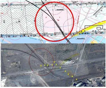
The boundaries of the danger zone were applied to mining plans T. Kuzembaev mine and presented as a circle in Figure 1. They were obtained by superimposing the mining plans of the mine on the image taken from Google maps. In the center of this area is the intersection of the railway track and the A17 freeway (MozerD., FofanovO., YavorskiyV., 2014 ).
Figure 1. Determination of the undermined territory and overlapping on the territory plan in Google Maps ISPRS Annals of the Photogrammetry, Remote Sensing and Spatial Information Sciences, Volume III-6, 2016
XXIII ISPRS Congress, 12–19 July 2016, Prague, Czech Republic
This contribution has been peer-reviewed. The double-blind peer-review was conducted on the basis of the full paper.
For implementation of monitoring and determination of charac-ter and sizes of displacements and deformations of a charac-terrestrial surface in the area of T. Kuzembayev mine two observational stations were installed in May, 2014. Systematic instrumental monitoring using Leica NA 730 optical level is carried out (Figure 2).
Figure 2. Carrying out of a ground monitoring
According to (Monserrat, O., Crosetto, M., Luzi, G., 2014), the time interval between the re-leveling set, based on the expected velocity of recent vertical crustal movements. Detailed infor-mation about the process of displacement, in addition to the initial and final observations, carried out at least 5 sets of obser-vations over the interval:
c H t
6
= 36, days, (1)
where H – is the depth of development at the lower boundary working in meters;
c - speed of displacement slaughter, meters per day.
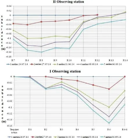
Integrated results of 5 series of leveling are shown in the graphs in Figure 3.
Figure 3. Graphical representation of the earth surface subsidence profile lines as a result of levelling
Work within the limits of the dangerous section was conducted from April to September, which is about 6 months. During this period, coal was mined in the area. Comparing our results with the results of theoretical calculations, it can be noted that the magnitude of subsidence, measured over a period of 6 months differs by 20%. The maximum value of subsidence during this period amounted to 0.16m (leveling) and 0.2 m on theoretical calculations.
DEFINITION OF UNDERMINED EARTH'S SURFACE DISPLACEMENT NEAR KUZEMBAEVA MINE BY
METHOD OF THE SATELLITE RADAR INTERFEROMETRY
Currently there are 2 archival chains of radar space pictures from the ENVISAT and ALOS satellite for the territory of Karaganda city. Processed space pictures from ENVISAT satel-lite showed not absolutely good results. It is connected with lack of a full-fledged chain of pictures of one and the same track of the big temporary and basic line. It is possible to distin-guish COSMO_SkyMed, Italy and TerraSAR-X, Germany from the existing satellite systems. Basing on the territory of interest and shooting time the Italian satellite was chosen for implemen-tation of the project.
Figure 4 depicts some quicklooks of the satellite scenes de-ployed in the described research (Moser, D., Tuyakbay, A., Gey, N., Nagibin A., Satbergenova A.,2014).
OSMO_SkyMed TerraSAR-X ENVISAT ASAR
Figure 4. Selected satellite imagery quicklooks deployed for the research project
Research was based on fifteen images from satellite COSMO-SkyMed (Italy) which were made in April – October, 2014 in the high-resolution mode “Stripmap”. Processing of satellite images was carried out by means of ENVI SarScape module (Hebel, H.-P., Busch, W., Schäfer, M., Walter, D., 2008).
Pairs of space pictures for further processing were chosen in the "Connection Graph tool" of ENVI program in the automated mode. As a result two graphs, which display pairs of space pictures as connections in the network connecting each image with another, were created (figure 5).
ISPRS Annals of the Photogrammetry, Remote Sensing and Spatial Information Sciences, Volume III-6, 2016 XXIII ISPRS Congress, 12–19 July 2016, Prague, Czech Republic
This contribution has been peer-reviewed. The double-blind peer-review was conducted on the basis of the full paper.
Figure 5. Definition base lines of pictures
According to the results of image processing, it was determined that the best pairs of images, with normal baseline to 1000 meters and a small time base to 10 days, and for each of them interferograms (Figure 5) were built (Mansurov, V., Satov, M., Jantuev, R., Kantemirov ,Y., 2012).
Results of processing of radar pictures showed that from April to November there was an intensive formation of subsidence area around a railway crossing and the A17 road. These subsid-ence troughs are located in areas of coal mining of T. Kuzem-bayev mine (Figure 6).
Figure 6. Samples of differential interferogram of the area of T.Kuzembaev mine based on different image pairs
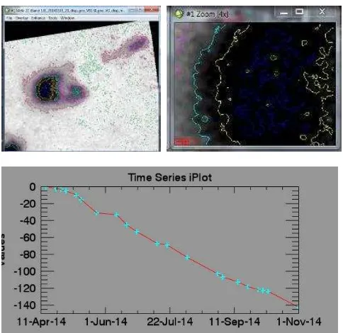
As a result of space pictures processing subsidence isolines and earth surface subsidence graph for the specific point with the maximum subsidence were made. From the schedule it is nota-ble that the maximum subsidence during supervision period made more than 145mm (Figure 7).
Figure 7. Isolines and subsidence graph based on 22 space pictures of the territory of T. Kuzembayev mine
From the graphs in Figure 7 it shows that the maximum subsid-ence during the observation period was 0.145 m. The graph shows that at the point of maximum surface subsidence for the period from April to October, 2014 there is a good correlation between the results of ground measurements and satellite radar monitoring.
According to monitoring results , the coal department of Mittal Steel Temirtau. The recommend to add additional sections to the base construction of electric transmission lines, which are on the territory of undermined. In the spring of 2015 electric transmission lines have been reconstructed, thus avoiding break-ing high-voltage wires and to prevent disturbance situations. (Figure 8)
Figure 8. The reconstructed electric transmission lines, which are on the undermined territory of Kuzembaev mine.
This allows make a conclusion about the possibility of using satellite radar interferometry in practical problems of displace-ment monitoring the earth's surface on undermined areas.
CONCLUSIONS
Values of the ground surface subsidence, obtained by different methods showed good correlation. In this case, the satellite radar interferometry for displacement monitoring of undermined earth surface area has a number of advantages over trad itional methods subsidence surveying and calculation. It should also be ISPRS Annals of the Photogrammetry, Remote Sensing and Spatial Information Sciences, Volume III-6, 2016
XXIII ISPRS Congress, 12–19 July 2016, Prague, Czech Republic
This contribution has been peer-reviewed. The double-blind peer-review was conducted on the basis of the full paper.
noted that it allows us to observe large territory and get visible results and timing of observations depending on the demands. This allows us to recommend satellite radar interferometry as a reliable method for monitoring of subsidence and deformations of the rock mass.
ACKNOWLEDGEMENTS
Authors would like to express their gratitude to German Aca-demic Exchange Service DAAD for the grant supporting of this research under the leadership of professor V. Bush at technical university of Сlausthal.
We would also like to extend our appreciation to the Scientific Committee of the Ministry of Education and Science of the Republic of Kazakhstan for the allocating grant # 1596 of Sep-tember 21, 2012. Our sincere appreciation is extended to the colleagues in the Department of Mine Surveying and Geodesy for ongoing technical assistance and discussion in the course of this work and to the center of Commercialization of technolo-gies of the Ministry of Education and Science of the Republic of Kazakhstan within which the conducted research is implement-ed.
REFERENCES CITED
Ferretti, A., Perissin, D., Prati C., Rocca, F., 2004. ERS -ENVISAT Permanent Scatterers, Geoscience a nd Remote Sens-ing Symposium, 2004. IGARSS '04. ProceedSens-ings. 2004 IEEE Internationa l (Volume:2 ), pp. 985 - 988.
Hanssen, R. F., 2001. Ra da r Interferometry: Data Interpreta -tion a nd Error Ana lysis, Kluwer Academic Publish., Dordrecht, 328 p.
Hebel, H.-P., Busch, W., Schäfer, M., Walter, D., 2008. Subsid-ence monitoring over a collapsed mine in Berezn iki, Russia. Proceedings of the 3rd Terra SAR-X Science Tea m Meeting, 25-26 November 2008, DLR, Oberpfaffenhofen, Germany.
Knospe, S., Busch, W., 2009. Monitoring a tunneling in an urbanized area with Terrasar-X interferometry - Surface defor-mation measurements and atmospheric error treatment. Geosci-ence a nd Remote Sensing Symposium,2009 IEEE Internationa l, IGARSS 2009(Volume:2), pp. II-25 - II-28.
Mansurov, V., Satov, M., Jantuev, R., Kantemirov ,Y., 2012. Space Radar Monitoring of Earth surface and structures on the Zhezkazgan copper deposit, Journa l of geoinformatics a nd remote sensing of the ea rth, 2012(1):77-83.
Monserrat, O., Crosetto, M., Luzi, G., 2014. A review of ground-based SAR interferometry for deformation measure-ment, ISPRS Journa l of Photogra mmetry and Remote Sensing, 93:40–48.
Moser, D., Tuyakbay, A., Gey, N., Nagibin A., Satbergenova A.,2014. Monitoring of the undermined Karaganda coal basin using satellite radar interferometry, Procs. of Intergeo-Siberia , Novosibirsk, Russia, April 2014.
Niemeier, W., Lehmann, M., Riedel, B., 2013. Qualitätssich e-rung bei der terrestrischen Radar-interferometrie. In
Schriften-reihe des DVW: Qualitätssicherung geodätischer Mess- und Auswerteverfa hr en, Augsburg, Band 71.
Schunert, A., Michaelsen, E., Sörgel, U., 2011. Perceptual grouping for persistent scatterers in urban high-resolution SAR images. In: Proceedings of IEEE Internationa l Geoscience a nd Remote Sensing Symposium (IGARSS), Va ncouver, 2011, pp. 2708-2711.
Wang Yunjia, Wang Jian, Huang Yi, Tian Feng, Chen Guoli-ang., 2013. Technologies and applications for multi-source monitoring of surface disasters in mining area, Internationa l Society for Mine Surveying XV Internationa l ISM Congress 2013, Deutscher Ma rkscheider -Verein e.V. – DMV, 16–20 September, Aachen, Germany, pp. 1034-1048.
Ozhigina S., Urdubayev R., Ozhigin D., Ozhigin S. Monitoring stability boards of deep open pit jsc «SSGPO». Interexpo Geo-Siberia -2015. XIth Internationa l scientific congress: Internationa l Scientific Conference «Geodesy , geoinforma tics , ca rtogra phy , mine survey». Novosibirsk, SSUGT, 2015. Volume 1, part 2, pp. 210-215.
Ozhigin S., Nizametdinov F., Ozhigina S., Ozhigin D. Innovative methods of monitoring of the condition of stability of rocks andterrestrial surface. Interexpo Geo-Siberia -2014. Xth Internationa l scientific congress: Internationa l Scientific
Conference «Geodesy , geoinformatics , cartography , mine survey». Novosibirsk, SSAG, 2014. Volume 1, part 1, pp. 135-140.
MozerD., FofanovO., YavorskiyV., 2014. Space Monitor-ing of Man-Made Hazards in Central Kazakhstan, Mecha nica l Engineering, Automa tion a nd Control Systems (MEACS), 2014 Internationa l Confer ence. ISBN: 978-1-4799-6220-4 Tomsk pp 1-4.
ISPRS Annals of the Photogrammetry, Remote Sensing and Spatial Information Sciences, Volume III-6, 2016 XXIII ISPRS Congress, 12–19 July 2016, Prague, Czech Republic
This contribution has been peer-reviewed. The double-blind peer-review was conducted on the basis of the full paper.