PRELIMINARY RESULTS OF THE COMPARISON OF SATELLITE IMAGERS USING
TUZ GÖLÜ AS A REFERENCE STANDARD
Hilal Özen1*, Nigel Fox2, S. Z. Gürbüz1,3, A. Deadman2, I. Behnert2, P. Harris2, L. Yua4, D. Griffith5, M. Kaewmanee6, A. Prakobya6, C. Musana6, F. Ponzoni7, D. Lee8, Y. Lee8, Y. Boucher9, F. Viallefont9, P. Rolland9, D. Helder10, L. Leigh10, K. Thome11,
S. Sterckx12, E. Knaeps12, D. Raeymaekers12 and P. Henry13
1 TUBITAK UZAY, METU Campus, 06531 Ankara, Turkey – (hilal.ozen, sevgi.gurbuz)@uzay.tubitak.gov.tr
2 NPL, TW11 0LW Teddington Middlesex, UK – (nigel.fox, andrew.deadman)@npl.co.uk
3 TOBB ETÜ, Dept. of Electrical and Electronics Eng., Söğütözü/Ankara, Turkey – [email protected] 4CMA, No.46, Zhongguancun Nandajie, Haidian District, Beijing, China – [email protected]
5CSIR, Moreletta St, Silverton 0184, South Africa – [email protected]
6
GISTDA, Chaeng Wattana Road, Lak Si, Bangkok 10210, Thailand – (Mkaewmanee, amornprk, chaichat)@eoc.gistda.or.th
7INPE, 12630-000 Cachoeira Paulista, Sao Paulo, Brazil – [email protected]
8
KARI, 115 Gwahanno Yuseong Daejeon, Korea – (dglee, [email protected]) 9ONERA, BP74025, 2 Avenue Edouard Belin, FR-31055 Toulouse, France –
(yannick.boucher, francoise.viallefont, philippe.rolland)@onera.fr 10
SDSU, Electrical Engineering, Brookings, SD 57007, USA – (dennis.helder, larry.leigh)@sdstate.edu 11NASA, Goddard Space Flight Center, Greenbelt, Maryland 20771, USA – [email protected]
12 VITO, Boeretang 200 BE-2400 MOL, Belgium – (sindy.sterckx, els.knaeps, dries.raymaekers)@vito.be
13CNES, 18 Avenue Edouard Belin, 31401 Toulouse, France – [email protected]
Commission I, WG I/4
KEY WORDS: Remote Sensing, Satellite, Sensor, Calibration, Comparison
ABSTRACT:
Earth surfaces, such as deserts, salt lakes, and playas, have been widely used in the vicarious radiometric calibration of optical earth observation satellites. In 2009, the Infrared and Visible Optical Sensors (IVOS) sub-group of the Committee of Earth Observation Satellites (CEOS) Working Group on Calibration and Validation (WGCV) designated eight LANDNET reference sites to focus international efforts, facilitate traceability and enable the establishment of measurement “best practices.” With support from the European Space Agency (ESA), one of the LANDNET sites, the Tuz Gölü salt lake located in central Turkey, was selected to host a cross-comparison of measurement instrumentation and methodologies conducted by 11 different ground teams across the globe. This paper provides an overview of the preliminary results of the cross-comparison of the ground-based spectral measurements made during the CEOS Land Comparison 13-27 August, 2010with the simultaneous satellite image data acquisitions of the same site.
1. INTRODUCTION
Earth surfaces, such as deserts, salt lakes, and playas, have been widely used in the vicarious radiometric calibration of optical earth observation satellites. In 2009, the Infrared and Visible Optical Sensors (IVOS) sub-group of the Committee of Earth Observation Satellites (CEOS) Working Group on Calibration and Validation (WGCV) designated eight LANDET reference sites to focus international efforts, facilitate traceability and enable the establishment of measurement “best practices.” With support from the European Space Agency (ESA), one of the LANDNET sites, the Tuz Gölü salt lake located in central Turkey, was selected to host a cross-comparison of measurement instrumentation and methodologies conducted by 11 different ground teams across the globe, including:
• Scientific and Technological Research Council of Turkey (TUBITAK) Space Technologies Research Institute - UZAY (Turkey),
• National Physical Laboratory – NPL (UK), • French Aerospace Laboratory – ONERA (France),
• Flemish Institute for Technological Res. – VITO (Belgium),
• National Aeronautics and Space Administration. – NASA (USA),
• Geo-Informatics and Space Technology Development Agency – GISTDA (Thailand),
• Korean Aerospace Research Institute – KARI (S. Korea), • South Africa Council for Scientific and Industrial Research
– CSIR (South Africa),
• Chinese National Satellite Metrological Centre – NSMC/CMA (China),
• Brazilian National Institute for Space Research – INPE (Brazil), and
• South Dakota State University – SDSU (USA).
This paper compares the ground-based spectral measurements made during the CEOS Land Comparison 13-27 August, 2010 with simultaneous satellite image data acquisitions of ENVISAT MERIS, ALOS AVNIR-2, EO-1 ALI, LANDSAT 5 TM, LANDSAT 7 ETM, and THEOS over the same site, Tuz Gölü, Turkey (Özen, et. al, 2011a) (Fig. 1).
International Archives of the Photogrammetry, Remote Sensing and Spatial Information Sciences, Volume XXXIX-B1, 2012 XXII ISPRS Congress, 25 August – 01 September 2012, Melbourne, Australia
The objective of the study was to cross-compare the satellite measured radiometric data with each other, corrected for spatial, spectral and view angle and with ground measured data averaged from the results of the ten independent ground teams.
Figure 1 Location of Tuz Gölü LANDNET site
The cross-comparison was performed by comparing Top-of-the-Atmosphere (TOA) reflectances from satellite imagery with that propagated to TOA reflectances through the radiative transfer code 6S (Behnert, et. al, 2011 and Özen, et. al, 2011b). The analysis was carried out by a community agreed method and identifies a number of biases in the sensor measured values.
2. METHODOLOGY
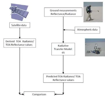
During the CEOS Land Comparison 2010, images from different optical sensors were acquired over the Tuz Gölü salt lake. These images were compared with the ground measurements taken during the CEOS Land Comparison 2010. The comparison methodology used is presented in the flowchart in Figure 2. Satellite images were acquired over the measurement site at Tuz Gölü test site at the same time the ground measurements were conducted (Fig. 3a). The TOA reflectances were derived from these images. The measurement site consisted of eight areas of the size of 100 m x 300 m and an area of the size of 1 km x 1km (Fig. 3b). These areas were measured by 11 different teams alternately (Özen, et. al, 2011a). For this study a mean value of the ground measurements was obtained over six areas of the size of 100 m x 300 m representing the measurement site as enclosed in red in Figure 3. Afterwards, TOA reflectances were simulated from ground measurement reflectance data together with the atmospheric data by running a radiative transfer code. In this analysis, the 6S (Second Simulation of a Satellite Signal in the Solar Spectrum) radiative transfer code was used (Vermote et. al., 1997). Finally, the percent differences of the TOA reflectances were calculated for comparison.
Figure 2. Flowchart of the comparison methodology used
3. RESULTS
When comparing images from different sensors, there are three advantages to using TOA reflectance instead of at-sensor spectral radiance (Haque et. al., 2010). First, it removes the cosine effect of different solar zenith angles due to the time difference between data acquisitions. Second, TOA reflectance compensates for different values of the exo-atmospheric solar irradiance arising from spectral band differences. Third, the TOA reflectance corrects for the variation in the Earth-Sun distance between different data acquisition dates. These variations can be significant geographically and temporally. Different sensors with different overpass times and different spatial and spectral characteristics acquired images of the Tuz Gölü site on different days during the CEOS Land Comparison 2010. Therefore, in this study TOA reflectances were compared instead of TOA radiances. The ground measurements were used to predict the TOA reflectance values and compare them with the TOA reflectances derived from satellite data.
(a) International Archives of the Photogrammetry, Remote Sensing and Spatial Information Sciences, Volume XXXIX-B1, 2012
XXII ISPRS Congress, 25 August – 01 September 2012, Melbourne, Australia
(b)
Figure 3. Representative measurement area of the site enclosed in red: a) on THEOS image acquired on August 19th, 2010; b) on map sketch with eight areas of the size of 100 m x 300 m, an area of the size of 1 km x 1km and two 50 m x 50 m tarpaulins
The TOA reflectance percent differences calculated for ENVISAT MERIS, ALOS AVNIR-2, EO-1 ALI, LANDSAT 5 TM, LANDSAT 7 ETM, and THEOS satellite images are summarized in Figure 4. The TOA reflectance average percent difference between most of the satellite images agreed within 10% for acquisitions over Tuz Gölü site in the blue, green and NIR range of the spectrum.
Figure 4. Comparison of TOA reflectance percent differences of satellite images of the CEOS Land Comparison 2010 over Tuz Gölü
To compare the daily averages of the satellite data derived and 6S radiative transfer code predicted TOA reflectances of the CEOS Land Comparison 2010 over Tuz Gölü Figure 5 was graphed. On 18.08.2010, the only satellite image available was the LANDSAT 5 TM image. Unfortunately, the blue band was saturated. Therefore, in Fig. 5 there was no value for the blue band on the 18th of August. The ground measurements at CEOS Land Comparison 2010 were conducted on 17-25 August 2010. There were no satellite acquisitions on 24.08.2010. The more satellite acquisition on a specific day the more the derived and predicted values were close in value.
Figure 5. Daily averages of the satellite data derived and predicted TOA reflectances of the CEOS Land Comparison 2010 over Tuz Gölü
4. CONCLUSION
The CEOS Land Comparison 2010 was conducted on 13-27 August, 2010 with the international participation of 11 different scientific ground measurement teams at the Tuz Gölü test site. Concurrently, satellite images were acquired over the measurement site. These satellite images were collected from different sensors with different overpass times and different spatial and spectral characteristics on different days over the Tuz Gölü site. This paper summarizes the preliminary results of the cross-comparison of the ground measurements that were used to predict the TOA reflectance values and the TOA reflectances derived from satellite data.
5. ACKNOWLEDGEMENT
We would like to acknowledge the willingness and professional commitment of the scientific teams that joined the field campaign during CEOS Land Comparison 2010. Authors also thank the agencies that have contributed with satellite data for the cross-comparison study. Finally, we would like to thank ESA for financing this work through the CONTROLS project.
6. REFERENCES
Behnert, I., A. Deadman, N. Fox, P. Harris, H. Özen, L. Yuan, D. Griffith, M. Kaewmanee, A. Prakobya, C. Musana, F. Ponzoni, D. Lee, Y. Lee, Y. Boucher, F. Viallefont, P. Rolland, D. Helder, L. Leigh, S. Sterckx, E. Knaeps and D. Raeymaekers, 2011. CEOS Key comparison of techniques and instruments used for the vicarious calibration of Land surface imaging through a ground reference standard test site 2010. Quality Assurance Framework for Earth Observation (QA4EO) documentation, National Physical Laboratory, UK.
Gürol, S., H. Özen, U.M. Leloğlu and E. Tunalı. Tuz Gölü: new absolute radiometric calibration test site. ISPRS, Beijing, China, 3-11 Jul 2008.
International Archives of the Photogrammetry, Remote Sensing and Spatial Information Sciences, Volume XXXIX-B1, 2012 XXII ISPRS Congress, 25 August – 01 September 2012, Melbourne, Australia
Gürol, S., Behnert, I., Özen, H., et. al., 2010. Tuz Gölü: new CEOS reference standard test site for infrared visible optical sensors. Canadian J. Rem. Sens., Vol. 36, No. 5, pp. 553-565.
Gyanesh, C. Catalog of Worldwide Test Sites for Sensor Characterization Catalog Characterization. ASPRS, USA, 9-13 Mar 2009.
Haque, O., A., Sampath and G., Chander, Radiometric & Geometric Assessment of the Data from RapidEye Constellation of Satellites. JACIE Meeting, March 16-18, 2010. Sioux Falls, USA.
Özen, H., N. Fox, U. M. Leloğlu, I. Behnert and A. Deadman, 2011a. The Tuz Gölü Field Campaign - an overview. IGARSS 2011, IEEE International Geoscience and Remote Sensing Symposium on 24-29 July 2011, Vancouver, Canada.
Özen, H., N. Fox and A. Deadman, 2011b. CEOS Comparison of Satellite Imagers Using Tuz Gölü as a Reference Standard 2010. Quality Assurance Framework for Earth Observation (QA4EO) documentation, National Physical Laboratory, UK. (draft)
Vermote, E. F., D. Tanré, J. L. Deuzé, M., Herman, and J. J. Morcette, (1997), Second simulation of the satellite signal in the solar spectrum, 6S: An overview. IEEE Transactions on Geoscience and Remote Sensing 35(3), 675-686.
International Archives of the Photogrammetry, Remote Sensing and Spatial Information Sciences, Volume XXXIX-B1, 2012 XXII ISPRS Congress, 25 August – 01 September 2012, Melbourne, Australia