ENHANCING THE REUSE OF DIGITAL RESOURCES FOR INTEGRATED SYSTEMS
TO REPRESENT, UNDERSTAND AND DYNAMIZE COMPLEX INTERACTIONS IN
ARCHITECTURAL CULTURAL HERITAGE ENVIRONMENTS
Francisco J. Delgado, Ruben Martinez, Jaime Finat, Jose Martinez, Julio C. Puche and F. Javier Finat∗
MoBiVAP Research Group Computational Vision Group Scientific Park at University of Valladolid
Valladolid, Spain
[email protected], [email protected]
KEY WORDS:3D GIS, Interaction, Augmented Reality, Serious games
ABSTRACT:
In this work we develop a multiply interconnected system which involves objects, agents and interactions between them from the use of ICT applied to open repositories, users communities and web services. Our approach is applied to Architectural Cultural Heritage Environments (ACHE). It includes components relative to digital accessibility (to augmented ACHE repositories), contents management (ontologies for the semantic web), semiautomatic recognition (to ease the reuse of materials) and serious videogames (for interaction in urban environments). Their combination provides a support for local real/remote virtual tourism (including some tools for low-level RT display of rendering in portable devices), mobile-based smart interactions (with a special regard to monitored environments) and CH related games (as extended web services). Main contributions to AR models on usual GIS applied to architectural environments, concern to an interactive support performed directly on digital files which allows to access to CH contents which are referred to GIS of urban districts (involving facades, historical or preindustrial buildings) and/or CH repositories in a ludic and transversal way to acquire cognitive, medial and social abilities in collaborative environments.
1 INTRODUCTION
Progressive deterioration or even disappearance of CH resources, economic crisis (emigration and unemployment, as undesirable effects) and the lack of economic return (arising from institutions and private entities) have generated a serious problem for knowl-edge and mise-in-value of Cultural Heritage resources as cultural, social and economic actives. It is necessary to dynamize and ar-ticulate available resources which can provide an educational, so-cial and economic return in terms of a soso-cial cohesion and more sustainable Cultural Tourism, specially in less-developed regions with very meaningful CH resources. To ease the reuse of mul-timedia contents available at Internet and users interaction, it is convenient to start from Web 2.0 framework and migrate towards Web 3.0 by extending usual approaches. We have developed this extension by using RDF schemata for ruins of churches in rural zones and small villages of Valladolid (Spain). This strategy en-ables end user creation of web content, and thereby encourages social networking which are crucial to improve communication of CH contents. His approach allows to recover a memory of un-fortunately destroyed past and to understand the current reality. However, it does not generate a meaningful return to dynamize cultural zones which are depressed from the economic viewpoint and with a scarcely articulated social tissue due to the lack of resources.
Our proposal for cultural dynamization uses mobile devices for in-situ AR-based interaction as support. It is based on the devel-opment of multiple articulations between production, extraction and management of architectural heritage digital contents. The design and implementation of multiple articulations are focused to enhance and reinforce the economic, educational and cultural value of digital actives. Usual integration is holding at horizon-tal level, i.e in terms of access and reuse of a distributed network of digital repositories with CH contents belonging to different
∗Corresponding author
regions or countries; reuse is performed in terms of a shared lex-icon. Instead, our approach is more focused towards the integra-tion at vertical level i.e. towards an interacintegra-tion between docu-mentation, information and management systems (DIMaS). This scheme involves to digital objects, processing and analysis tools (for image- and range-based information) and services (includ-ing assess(includ-ing rehabilitation tasks) to be applied to CH goods in the framework of the Semantic web. The fixation of an appro-priate Ontology makes possible queries in depth (from the lex-icon), discovery of relations between resources/tools (from the-sauri) and the application/development of systems of rules (from propositional or descriptive logics). To achieve this goal in an effective way, we have developed an Ontology which is transver-sal to the three levels along vertical direction. This CH Ontology has been applied in architectural Cultural Heritage including doc-umentation (photogrammetric surveying and monitoring referred to updatable 3D models), information (by following typical GIS strategies) and management modules (for assisting decision mak-ing in accessibility issues, e.g.)
cre-tographic representation) where all places of interest are geo-referenced; in our case, we have identified more than one hun-dred CH sites in the city of Valladolid (Spain). Very nice global reconstructions of well-documented sites have been performed for large cities of the Roman empire in Europe, having into ac-count historical research and archaeological excavations (Guidi et al., 2005) and including very illustrative advanced immersive projections (Giannakidis, 2011).
Our presentation tries of answering to several basic issues con-cerning to communication of CH contents by using Augmented Reality resources. Next section proposes an answer to what com-municate in terms of an Augmented Reality (AR) model which can support additional layers linked to Advanced Visualization Tools; in particular, knowledge management can be performed by semantic layer which to solve interoperability issues. Next issue concerns to where and how to communicate; for an efficient Real Time (RT) interaction in outdoor environments we need to sim-plify environment representations and to display visualization of reduced meaningful contents. How and with whom interact poses the problem of fusion of information arising from embedded sen-sors in mobile devices (smart phones and tablets) for SLAM and image processing (transformation between polygonals) support-ing the deployment of AR solutions. Last issue concerns to a justification of creation of simplified contents which is presented in section five. Our approach poses more advanced challenges for interactive visualization of disappeared urban environments with CH interest. Our solutions are described in terms of the ongoing work involving AR and Advanced Visualization Tools.
2 WHAT TO COMMUNICATE?
Most initiatives are organized following a quantitative approach, with a focus towards linking repositories in a distributed CH net-work following a ”flexible, scalable, secure and reliable infras-tructure; a typical recent example is provided by Europeana net-work. Following this approach, from a collection of ”linked data enabled” cultural heritage information repositories will emanate a better knowledge and mise-in-value of Cultural goods and re-sources. Currently, there is a very large amount of information in CH repositories, which can be reused if interoperability issues are adequately solved. Interoperability is a semantic issue which requires complex solutions in the Web Semantic framework. To fix ideas, we restrict ourselves to the lowest level involving a lex-icon, i.e a previously specified list of key words. Very often, an-notation is very incomplete and involves only to a very limited number of elements which are considered as meaningful by the expert in charge of annotation. It would be necessary to develop a more systematic approach which could include the viewpoint of other experts in the framework of collaborative environments, and to try of developing expert systems in charge of reinterpreting available multimedia contents.
From linguistic and computational viewpoint, real-time semiau-tomatic recognition of architectural primitives is a far-reaching
(in terms of a collection of key words) from images. This task re-quires iconological studies in regard to CH contents and software tools for knowledge representation and management in symbolic terms. This ambitious goal can be achieved in some cases; for example, some visible structural architectural elements (walls, columns or vaults, e.g.) can be easily recognized in terms of volumetric characteristics. However, the very large diversity of decorative elements makes still very difficult to provide a general solution for this problem. Hence, for remote access to CH repos-itories we restrict ourselves to annotated contents according to an explicit lexicon. Currently, there are different lexicons and the-sauri which must be automatically aligned in the framework of the Semantic Web to ease the interoperability between different repositories. Unfortunately, there is no still an agreement about commonly accepted methodologies which can be applied to CH domains. The limitations of current methodologies and alignment techniques applied to Geospatial ontologies are discussed in (Del-gado et al., 2013). The SKOS (Simple Knowledge Organization System) has developed a Primer (Miles et al., 2005) with specific recommendations and software tools in the W3C Working Group which can be applied to CH repositories. However, most reposi-tories have not still organized following semantic criteria, and the lexicon is not adequately specified.
To improve the current state, it is necessary to combine educa-tional and social contents supported by a visualization of CH con-tents. This combination requires standardization in contents as a common support for advanced ICT, and the development of new narrative styles for an appropriate contents transmission. We are adopting a scheme inspired by (Jacobson et al., 2009) in a very bounded architectural environment.
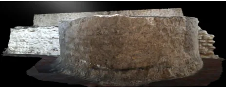
The application of typical architectural surveying techniques (im-age and range based) by means of calibrated cameras and laser devices are very useful for a professional presentation of the cur-rent state of archaeological sites. In particular, their combina-tion has allowed to construct a three-dimensional model of some zones which are not accessible for most citizens. The figure 1 displays the remapping of original textures on a volumetric mesh corresponding to some underground vestiges.
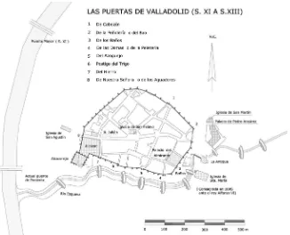
Figure 2: Wall doors of Valladolid in the 11th century
• Efficiency oriented methodswhere the performance or
qual-ity of a System is evaluated w.r.t. some predefined techni-cal and functional specifications. This evaluation provides a link between Documentation and Information Systems rela-tive to repositories: Its evaluation is obtained from dialogues with users, persistence of interactive navigation and sugges-tions performed through forums, blogs, and related social networks (including users and developers communities).
• Understanding-oriented approacheswhich is focused towards
a deeper understanding of value generation by systems and their association with the organizational context. This cate-gory concerns mainly to the knowledge linked to Informa-tion Systems linked to repositories and can be measured by the interactive contributions of users to digital contents (in-cluding generation of new digital contents)
• Effectiveness oriented methods which is oriented to try of
evaluating the induced dynamics in terms of the economic activity generated in Management Systems, the development of intermediate structures (Living Labs to give academic support to contents producers or mash-ups as communities of advanced final users).
However, the above images provide only a static representation which is not understandable for most people. It is convenient to generate a 3D model, superimpose it to the current represen-tation and link it with additional digital information contained in accessible repositories. Advanced Visualization Tools sup-port these functionalities and furthermore they are transversal to the DIMaS hierarchy. Indeed, they allow not only an interac-tive navigation around surveyed objects (documentation), but an access to different kinds of information sources linked to the dig-ital objects. In precedent papers, management issues were fo-cused towards conservation and intervention strategies involving CH resources management by the Regional Administration. In this work, a videogame-based interaction replaces the above ap-proach for management, and opens the door for enjoying cultural goods through technological resources.
2.1 An AR-based approach for historical contents
Our proposal is to provide a support to the ”Back to the Past” to have a better understanding of the current reality throughout successive transformations of the urban space as a representation of social and historic phenomena. In particular, our approach is based on a previously specified repository concerning to the Spanish city of Valladolid which is semantically annotated. We have identified more than one hundred places with cultural, his-toric and/or artistic interest in the old villa, which are adequately georeferenced. Near to each selected place, it will be possible to
Figure 3: The Alcazar surroundings in the 12th century
activate the application and navigate around old representations in an interactive way.
In this way, a walk in the current city will provide different repre-sentations which can be composed to obtain a global understand-ing of the evolvunderstand-ing historic environment. Our approach is under-stood as a simplified videogame, where it is necessary to discover meaningful elements which are interconnected with other places; so, we intend to contribute to generate a local representation of medieval buildings which is superimposed to the current urban trace.
To improve the understanding of past, we have developed a multi-platform solution which is based in Augmented Reality on mo-bile devices (Smart Phones and PC tablets). We illustrate the per-formed approach with a historic environment relative to a very limited quarter of Valladolid which concerns to the Alcazarejo (a contraction of ”Alcazar Viejo”) which is the primitive fortress in a vertex of the medieval city. There are archaeological vestiges which are not accessible for most public between 4 and 6 meters under the current level. Some simulations have been performed at a near square (Plaza Poniente) which are useful to provide an-other views of the environment. A schematic representation of our approach concerns to several key frames which are displayed in a consecutive way:
1. Right localization(position and orientation) of the citizen in regard to the environment which is performed by means of a mobile device able of processing georeferenced data (managed in terms of UTM coordinates in our case)
2. Understanding the current environmentwhich is performed in terms of zoom-in from aerial views and superposition of the the contour of medieval villa on the current zone (see Figure 2 for a historic recreation).
3. Replacement by an old pseudo-volumetric representationbased on a selected zone of the annotated representation provided by the plan of Bentura Seco (1738). Identification of per-formed transformations.
to some archaeological vestiges in the underground, there are no visible vestiges of the above described buildings. The building was constructed not only as a defense against Spanish arabs liv-ing in the South, but also as a defense of royal power against the population inside the walls. From 1390 the palace complex composed by the Alcazar Real and Alcazarejo were transformed along four centuries in one of the largest monasteries of the Bene-dictine order in West Europe. Thus, these buildings can only vi-sualized by using AR techniques for their representation.
The already performed basic version displays the above contents in a consecutive way, with a small interval between consecutive frames with simple zoom-in effects to focus the attention towards the most meaningful historical facts. If the mobile device has a tactile sensor, each one of the above steps can be navigated in an interactive way. In next versions a low-level dialogue will be de-veloped for each frame including progressively complex contents involving historical facts involving construction techniques, dif-ferent uses of castle-residence along almost three centuries, local government by the ten lineages, rebellions of population, and/or daily life in a medieval villa around the royal residence.
3 WHERE AND HOW TO COMMUNICATE?
In a broad sense both issues (where and how communicate) con-cern to some of the oldest problems in advertising. The most im-mediate answers are Internet and interactive playing as support. But at a more deep level, both issues concern to language to be used and the transparency of technologies to be used. Neverthe-less its simplicity and generalized banality of contents, simplified representations (including popular cartoons) display some of the most efficient ways of communicating. Hence, no support or no language can be previously excluded to improve the communica-tion of CH contents.
Recent developments of smart phones or tablets as support, cloud computing for web services everywhere and Augmented Reality for real-time interaction. Their fusion provides a general tech-nological framework to answer to the initial two issues (where and how). Following (Arth and Schmalstieg, 2011) there are two hard problems for mobile AR: registration and precision. Small errors in localization can generate unacceptable results in the ap-plication. Thus, it is necessary a robust estimation of localization parameters and accurate visualization of navigable models in the mobile smart phone screen, by minimizing the computation and memory usage. In (Guardia et al., 2012) one can see a general introduction which is related to our approach.
Some of the bottlenecks to be solved are the following ones: (a) Environmental conditions (including illumination), (b) energy consumption (AR), (c) availability of information in the network (simultaneous access, complexity of 2D/3D information), and (d) performance of interaction and visualization (in terms of different interaction types).
Figure 4: a) A virtual 3D reconstruction of the castle of Villarejo over a real image taken from camera; b) The same model on a mobile device using augmented reality
3.1 Some technological contributions
Ourcurrent contributionsare focused towards the two following issues:
• Availability of information: Our application supports
tex-tured models with more than five thousand control points. Low zooming, Refreshing, remeshing and/or remapping of textures under different illumination conditions can be cur-rently performed. High resolution models are not accessi-ble, still.
• Performance of interaction and visualization: Contrarily to
smart phones, tablets require usually both hands for interact. We have developed a software application which allows to interact with gaze control, by means the identification of 16 zones of the screen where attention is fixed.
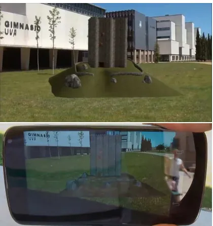
Figure 4 shows screenshots of a proof of concept of the AR ap-plication running in a mobile device and performed in the envi-ronment of M. Delibes Campus of the University of Valladolid.
4 HOW AND WITH WHOM TO INTERACT?
The interaction is focused towards different ways of interconnect-ing providers and consumers of CH resources, which are clas-sically designed. A typical server-client approach provides the support for this classical (and passive) approach. From the late nineties, serious games for mobile applications are an emerging technological field going from the lowest level web-based solu-tions for individual players to more advanced mash-up applica-tions for communities of users in more open collaborative en-vironments. A recent survey can be seen in (Anderson et al., December 2010). Luckily, we have at our disposal a pseudo-volumetric representation at urban scale which has been performed at 1738 by Bentura Seco (1738).
This representation provides a deformed model of the whole ur-ban trace at the first half of the 18th century: It is remarkable that Valladolid has back down along 17th and 18th centuries because the capital of Spain has been definitely moved to Madrid (1606). Nevertheless the Bentura’s false perspectives, this representation provides a faithful visualization of the development at the 16th century (and not only for 1738) which corresponds to the largest expansions of the medieval villa. The existence of this documen-tation justifies our choice for simple videogames; our approach is focused towards an individual player who is immersed in 2.5D representation. The video-game approach based in third person camera is more expensive and demands more computational re-sources; furthermore, its incorporation to mobile devices displays some hard technological problems which are not still solved.
If we look at the first issue (how interact), a first answer arising from image-based modeling concerns to the adaptation of SLAM (Simultaneous Localization and Mapping) strategies to mobile devices. Nowadays, it is not possible to deploy on smartphones complex solutions which require memory intensive algorithms; most solutions have been originally designed for desktop comput-ers. However, the increasing performance of miniaturized com-ponents allows to combine hardware devices (compass for ori-entation) and GPS (Global Positioning System) as a robust input which bounds the search range for queries involving meaning-ful buildings which has been applied to the already implemented solution.
Relative to CH contents, we have performed the documentation of a large zone of the historical center of Valladolid (Spain) in-cluding around two hundred sites of interest which are adequately georeferenced.
For some of these places (around La Antigua church and Monas-terio de San Benito), we have taken a collection of images which play the role of reference elements. These elements are com-pared with the images captured by a user to generate a dialogue. We have discarded other solutions (based in Google Street View, e.g.) to reinforce pedagogical aspects which very often are absent of commercial applications. In other words, the visitor must ex-plore the CH environment according to the approximate location of archaeological vestiges.
The methodology includes several steps which involve to image-based interaction. It is performed in terms of
1. Localization (position and orientation) of user in terms of GPS and compass of mobile device.
2. Comparison (in terms of homographies) between polygo-nals involving to the sky-line of buildings.
3. Automatic selection of zones of facades which are relevant from the CH viewpoint according to the information avail-able at the CH database.
4. Optional deployment of virtual worlds for interactive expe-riences, as well as mixed reality games.
5. Combination of real and virtual interactions in CH environ-ments.
Technologies involve to an appropriate combination of Computer Vision, Computer Graphics, VR/AR and videogames. Their inte-grations and application to CH environments displays some com-plexity. The general goal is the provision of real-time 3D vi-sualization and simulation from user interaction. To fix ideas, we illustrate our approach with some examples arising from the Monasterio of San Benito (Valladolid) which was rebuilt since 1400 till 1750 on the demolished Alcazarejo and the old Real Al-cazar, the palace-fortresses of kings of Castilla in Valladolid till the end of 14th century.
The Alcazarejo was a small castle of quadrangular plant consist-ing of a big tower with cylindrical elements at corners and at the middle of each wall; it contains a small indoor patio which dis-tributes spaces and uses, following roman and Muslim tradition. It was constructed at the first half of the 13th century, more than a royal residence rather by their defensive characteristics. Nowa-days, there are some archaeological vestiges in the underground, including basis of cylindrical towers and some parts of walls. Un-fortunately, most of these vestiges are at 5 or 6 meters under the ground level and they are not accessible for most people. In fact most of population ignores these archaeological vestiges, this part of the medieval history and the role of the city in the Castilla kingdom till 16th century. To construct a virtual model of the Al-cazarejo, we have adapted materials arising from another similar castles which were constructed in the first half of 13th century, by following the tradition of Muslim kingdoms of taifas.
5 WHY CREATE NEW CULTURAL HERITAGE
CONTENTS?
Currently, there is a very large amount of disappeared CH con-tents or which is hidden under current buildings. Their visual-ization heps to understand the past, and consequently the present. Furthermore, related physical and human resources which could explain are underemployed. ICT and multimedia production have a very large potential to help to understand the reality at different depth levels by following discovery strategies. Re-creation of CH contents is the first part, but more advanced developments can be incorporated, also.
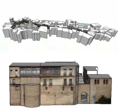
A drastic reduction of volumetric information arising from laser scan or rectified photogrammetry provides a collection of cuboids which simulate the current state of the city. This approach has been applied to the French city of Toul (Chevrier et al., 2010). We have applied a similar strategy to an urban district of the World Heritage Spanish city of Segovia (Spain), but the economic and computational cost are very high. To ease the interaction we need to develop cheaper solutions. In other words, to be more effective some technical aspects must be simplified;
Figure 5: a) The volumetric representation of the Real Street of Segovia using cuboids; b) A textured building model of the street
creation of new digital contents in connection with multimedia in-dustry. Seemingly, the proposed simplification is opposite to Pho-togrammetric Surveying, but it must be understood from a com-plementary viewpoint. Dissemination for large public is under-stood as a path for asking about more detailed information con-cerning to humanistic (historical, artistic, societal) aspects and professional solutions (photogrammetric surveying, historical ur-ban GIS, 3D modeling, augmented reality). This strategy pro-poses a common framework to integrate all of them in a seem-ingly funny way for user, but with a view to understand and val-orize the environment from the CH viewpoint.
6 CONCLUSIONS AND FUTURE WORK
Digitization of physical resources contained in large public repos-itories (museums, archives, Foundations) is the first step for val-orisation of CH goods. Their reuse can be performed through distributed networks which are organized by means of specific Ontologies. The lowest level supporting this organization con-cerns to metadata. Multiple articulations can be developed from specific CH metadata towards EU multimedia data to provide an Internet support to create new digital contents and constructing an European citizenship aware of CH richness as a reference for di-versity, tolerance and common values sharing. However, neither of these technological solutions contributes to make more sus-tainable the CH tourism if there are no visitors. In this work, we provide answers to several basic issues concerning to the commu-nication of CH contents by following an interactive strategy based in games with CH contents in historic urban environments. To achieve this goal, we have designed and implemented a software application which includes Web services, Augmented Reality and Serious Games to enhance cultural experiences through immer-sive interactions performed at mobile devices. This application is illustrated with some examples corresponding to a disappeared zone of Valladolid (Spain) relative to one of the four royal resi-dences in the Medieval Age (currently there is once, which has been converted in the enclosed Monastery of Las Huelgas). So, we intend to contribute to improve and valorize the knowledge of old times and their projection towards the future.
Next steps concern to the extension of this initial work to more complex buildings (Real Alcazar) or CH environments (around the Antigua church including already disappeared roman and me-dieval baths, and some parts of the wall of 11th century). In the
Results concerning to Segovia were obtained with a financial support of the Strategic Singular Project Patrac (Patrimonio Ac-cesible) with reference PSE-380000-2009-2. This project has been partly funded by the ”Ministerio de Ciencia e Innovacion” (MICINN) of Spain and has allowed the generation of the 2D map including the localization of old CH buldings in Segovia which are relevant from historical and societal viewpoints.
REFERENCES
Anderson, E., McLoughlin, L., Liarokapis, F., Peters, C., Petridis, P. and de Freitas, S., December 2010. Developing serious games for cultural heritage: a state-of-the-art review. Virtual Real 14(4), pp. 255–275.
Arth, C. and Schmalstieg, D., 2011. Challenges of large-scale augmented reality on smartphone. ISMAR 2011 Workshop: En-abling Large-Scale Outdoor Mixed Reality and Augmented Re-ality.
Chevrier, C., Jacquot, K. and Perrin, J., 2010. 3d modelling of a town scale model. 3rd EuroMed Conference, 8-13 Nov 2010, Limassol, Cyprus pp. 99–107.
Delgado, F., Martinez-Gonzlez, M. and Finat, J., 2013. An eval-uation of ontology matching techniques on geospatial ontologies. International Journal of Geographical Information Science.
Farbey, B., Land, F. and Targett, C., 2009. A taxonomy of in-formation systems applications: the benefits evaluation ladder. European J. of Information Systems 4, pp. 41–50.
Giannakidis, A., 2011. Towards a gaming platform for cultural heritage games – prototype design for the erechtheion temple of the athens acropolis. Blender Conference, Amsterdam.
Guardia, D. L., Arrigo, M. and Giuseppe, O. D., 2012. A location-based serious game to learn about the culture. The 2nd International Conference of the Future of the Education.
Guidi, G., Frischer, B., Simone, M. D., Cioci, A., Spinetti, A., L.Carosso, Micoli, L. L., Russo, M. and Grasso, T., 2005. Vir-tualizing Ancient Rome: 3D Acquisition And Modeling Of A Large Plaster-Of-Paris Model Of Imperial Rome. SPIE Video-metrics VIII.
Jacobson, J., Handron, K. and Holden, L., 2009. Narrative and content combine in a learning game for virtual heritage. Com-puter Application to Archaeology, Williamsburg, Virginia, USA.
Miles, A., Matthews, B., Wilson, M. and Brickley, D., 2005. Skos core: simple knowledge organisation for the web. International Conference on Dublin Core and Metadata Applications pp. pp–3.