Open Geospatial Consortium
Publication Date: 2015-11-19
Approval Date: 2015-09-17
Posted Date: 2015-08-26
Reference number of this document: OGC 15-075r1
Reference URL for this document:http://www.opengeospatial.net/doc/DP/indoorgml-mls-nav-vi
Category: Discussion Paper
Editors: Ki-Joune Li, Hyung-Gyu Ryu, Taehoon Kim, and Hack-Cheol Kim
A Use-Case for Mobile Location Services with IndoorGML
- Indoor Navigation for Visually Impaired People
.
Copyright © 2015 Open Geospatial Consortium.
To obtain additional rights of use, visit http://www.opengeospatial.org/legal/.
Warning
This document is not an OGC Standard. This document is an OGC Discussion Paper and is therefore not an official position of the OGC membership. It is distributed for review and comment. It is subject to change without notice and may not be referred to as an OGC Standard. Further, an OGC Discussion Paper should not be referenced as required or mandatory technology in procurements.
Document type: OGC® Discussion Paper Document subtype: NA
License Agreement
Permission is hereby granted by the Open Geospatial Consortium, ("Licensor"), free of charge and subject to the terms set forth below, to any person obtaining a copy of this Intellectual Property and any associated documentation, to deal in the Intellectual Property without restriction (except as set forth below), including without limitation the rights to implement, use, copy, modify, merge, publish, distribute, and/or sublicense copies of the Intellectual Property, and to permit persons to whom the Intellectual Property is furnished to do so, provided that all copyright notices on the intellectual property are retained intact and that each person to whom the Intellectual Property is furnished agrees to the terms of this Agreement.
If you modify the Intellectual Property, all copies of the modified Intellectual Property must include, in addition to the above copyright notice, a notice that the Intellectual Property includes modifications that have not been approved or adopted by LICENSOR. THIS LICENSE IS A COPYRIGHT LICENSE ONLY, AND DOES NOT CONVEY ANY RIGHTS UNDER ANY PATENTS THAT MAY BE IN FORCE ANYWHERE IN THE WORLD.
THE INTELLECTUAL PROPERTY IS PROVIDED "AS IS", WITHOUT WARRANTY OF ANY KIND, EXPRESS OR IMPLIED, INCLUDING BUT NOT LIMITED TO THE WARRANTIES OF MERCHANTABILITY, FITNESS FOR A PARTICULAR PURPOSE, AND NONINFRINGEMENT OF THIRD PARTY RIGHTS. THE COPYRIGHT HOLDER OR HOLDERS INCLUDED IN THIS NOTICE DO NOT WARRANT THAT THE FUNCTIONS CONTAINED IN THE INTELLECTUAL PROPERTY WILL MEET YOUR REQUIREMENTS OR THAT THE OPERATION OF THE INTELLECTUAL PROPERTY WILL BE
UNINTERRUPTED OR ERROR FREE. ANY USE OF THE INTELLECTUAL PROPERTY SHALL BE MADE ENTIRELY AT THE USER’S OWN RISK. IN NO EVENT SHALL THE COPYRIGHT HOLDER OR ANY CONTRIBUTOR OF
INTELLECTUAL PROPERTY RIGHTS TO THE INTELLECTUAL PROPERTY BE LIABLE FOR ANY CLAIM, OR ANY DIRECT, SPECIAL, INDIRECT OR CONSEQUENTIAL DAMAGES, OR ANY DAMAGES WHATSOEVER RESULTING FROM ANY ALLEGED INFRINGEMENT OR ANY LOSS OF USE, DATA OR PROFITS, WHETHER IN AN ACTION OF CONTRACT, NEGLIGENCE OR UNDER ANY OTHER LEGAL THEORY, ARISING OUT OF OR IN CONNECTION WITH THE IMPLEMENTATION, USE, COMMERCIALIZATION OR PERFORMANCE OF THIS INTELLECTUAL PROPERTY. This license is effective until terminated. You may terminate it at any time by destroying the Intellectual Property together with all copies in any form. The license will also terminate if you fail to comply with any term or condition of this Agreement. Except as provided in the following sentence, no such termination of this license shall require the termination of any third party end-user sublicense to the Intellectual Property which is in force as of the date of notice of such termination. In addition, should the Intellectual Property, or the operation of the Intellectual Property, infringe, or in LICENSOR’s sole opinion be likely to infringe, any patent, copyright, trademark or other right of a third party, you agree that LICENSOR, in its sole discretion, may terminate this license without any compensation or liability to you, your licensees or any other party. You agree upon termination of any kind to destroy or cause to be destroyed the Intellectual Property together with all copies in any form, whether held by you or by any third party. Except as contained in this notice, the name of LICENSOR or of any other holder of a copyright in all or part of the Intellectual Property shall not be used in advertising or otherwise to promote the sale, use or other dealings in this Intellectual Property without prior written authorization of LICENSOR or such copyright holder. LICENSOR is and shall at all times be the sole entity that may authorize you or any third party to use certification marks, trademarks or other special designations to indicate compliance with any LICENSOR standards or specifications.
This Agreement is governed by the laws of the Commonwealth of Massachusetts. The application to this Agreement of the United Nations Convention on Contracts for the International Sale of Goods is hereby expressly excluded. In the event any provision of this Agreement shall be deemed unenforceable, void or invalid, such provision shall be modified so as to make it valid and enforceable, and as so modified the entire Agreement shall remain in full force and effect. No decision, action or inaction by LICENSOR shall be construed to be a waiver of any rights or remedies available to it.
OGC 15-075r1
Contents
Page1 Introduction ... 2
1.1 Scope ... 2
1.2 Document contributor contact points ... 2
1.3 Future work ... 2
1.4 Forward ... 3
2 References ... 3
3 Conventions ... 3
3.1 Abbreviated terms ... 3
3.2 UML notation ... 4
3.3 Used parts of other documents ... 4
4 Voice-based Indoor Navigation Maps ... 4
5 Requirements of Voice-based Indoor Navigation Map ... 5
6 Key Design Concepts for VIM ... 5
6.1 Braille Block Network ... 5
6.2 Three Guiding Instructions – Walk, Stop, and Turn ... 6
6.3 Landmark Information ... 7
6.4 Landmark Information ... 8
7 VIM Data Model ... 8
8 Implementation ... 9
9 Conclusion ... 11
Figures
PageFigure 1 – Braille Blocks: Stop (left) and Walk (right) ... 6
Figure 2 – Braille Block Network ... 6
Figure 3 – Turning and Walking ... 7
Figure 4 – Four Directional Topologies of Landmark ... 8
Figure 5 – Extension of IndoorGML Core Module for VIM ... 9
Figure 6 – Splitting Nodes and Edges ... 9
Figure 7 – Example of Navigation Map in a Subway Station in Seoul ... 10
Figure 8 – User-Interface to Select Source and Destination (in text) ... 11
OGC® Discussion Paper OGC 15-075r1
Abstract
This OGC Discussion Paper provides a navigation use-case for the use of IndoorGML for mobile location services (MLS). In particular, the Discussion Paper explains how the OGC IndoorGML standard can be applied to a MLS application for visually impaired people in indoor space. Finally, a prototype development of the application on Android smart phone is described in this report.
Keywords
A Use-Case for Mobile Location Services with IndoorGML
– Indoor Navigation for Visually Impaired People
1 Introduction
1.1 Scope
This OGC® Discussion Paper describes a use-case of MLS (Mobile Location Services) to study how the OGC® IndoorGML standard can be applied to practical applications. In particular, the Paper focuses on an application of smart phones for guiding visually impaired people in indoor spaces with a voice-based navigation map implemented using IndoorGML. A prototype, called VIM (Voice-based Indoor navigation Map) is presented in this document. The prototype was developed on the Android OS for smart phones with the TalkBack1 function. Among mobile location services, it falls into the following
classifications;
Transportation mode: pedestrian Place type: indoor space (e.g. subway) Type of services: navigation
Constraints: visually impaired
1.2 Document contributor contact points
This engineering report is written by a collaboration between Pusan National University and Realtime Tech company funded by Geo-Content and 3D DBMS.
Name Organization
Ki-Joune Li Pusan National University
Hyung-Gyu Ryu Pusan National University
Taehoon Kim Pusan National University
Hack-Cheol Kim Realtime Tech. Company
1.3 Future work
Since this Discussion Paper is based on a prototype development, which will be improved with real site tests, subsequent versions of this report will contain more practical issues
OGC 15-075r1
about voice-based indoor navigation maps for visually impaired people. In particular, we expect that the following considerations are to be taken for robust services;
Inter-level navigation: In this report, we did not consider the movement between levels in a building, such as via lifts or stairs. For more convenient and seamless service, features for inter-level navigations are required.
Integration of accurate indoor positioning technologies: Current indoor positioning methods do not support accuracy to the level that indoor pedestrians require for indoor navigation. This is the reason that the braille block networks have been used for an alternative for the prototype. However, we expect that sufficient accuracy can be provided in the near future and therefore we will be able to rely on the indoor positioning method. At that time a certain component of the data model of VIM (Voice-based Indoor navigation Map) should be modified accordingly.
Improved user-interface: VIM is the first version of prototype. Improvements to the user-interface with repeated field tests based on the feedbacks from real users are required.
1.4 Forward
Attention is drawn to the possibility that some of the elements of this document may be the subject of patent rights. The Open Geospatial Consortium shall not be held responsible for identifying any or all such patent rights.
Recipients of this document are requested to submit, with their comments, notification of any relevant patent claims or other intellectual property rights of which they may be aware that might be infringed by any implementation of the standard set forth in this document, and to provide supporting documentation.
2 References
The following document is referenced in this document. OGC 14-005r3, OGC® IndoorGML
3 Conventions
3.1 Abbreviated terms
The following abbreviated terms are used in this engineering report; IndoorGML Indoor Geographic Markup Language
UML Unified Modeling Language
VIM Voice-based Indoor navigation Maps
3.2 UML notation
Most diagrams that appear in this standard are presented using the Unified Modeling Language (UML) static structure diagram.
3.3 Used parts of other documents
This document uses significant parts of the paper published in [3]. To reduce the need to refer to that document, this document copies some of those parts with small
modifications.
4 Voice-based Indoor Navigation Maps
Recent progress in mobile device and geospatial information technologies provides a platform for diverse navigation information services. In particular, car navigation and pedestrian navigation have become very popular as a smart phone application. These navigation and map services using smart phones are very useful for people with reduced mobility, including visually impaired people [4]. For example the BlindSquare service [1] provides pedestrian navigation services with smart phones for visually impaired people based on OpenStreetMap [9] data and iOS VoiceOver [10], which is a voice-based user-interface.
However, these services are mostly limited to outdoor space whereas most of our daily life is spent in indoor space. For this reason, we present a prototype of indoor route map service developed using TalkBack [8], which is voice-based user-interface in the Android OS. This prototype service, called VIM (Voice-based Indoor Map) assumes a braille block network of the indoor space, which is common in public indoor spaces in metropolitan cities such as subway stations.
This Discussion Paper is organized as follows:
Clause 5: Briefly discuss the requirements of voice navigation indoor maps for visually impaired people.
Clause 6: The basic design concepts are described.
Clause 7: The data model used for the prototype is presented.
Clause 8: The prototype implementation is described.
OGC 15-075r1
5 Requirements of Voice-based Indoor Navigation Map
Unlike ordinary indoor navigation and map services, indoor map services for visually impaired people have specific requirements [7]. We considered these requirements as the starting point of design and implementation of our prototype.
Requirement 1 - providing environmental information: It is very important to provide environmental information to visually impaired users of the prototype so that they quickly recognize the environmental situations around them. While non-visually impaired people easily figure out the environment by a quick look around them, visually impaired people need explicit verbal information about the environment. Even though the environment may be irrelevant to the navigation, the user may have better understanding about the environment and feel more comfortable and safe with the environmental information.
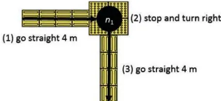
Requirement 2 - separation of turning from walking: While non-visually impaired people do not separate turning and walking during movement, we need to provide turning and walking guide instructions in separate ways.
Requirement 3 - using smart phones: One of our goals is to provide indoor navigation maps without any additional equipment except smart phones. Therefore, the prototype should exploit the functions offered by smart phones. Requirement 4 - braille block: Our prototype does not use any indoor positioning
method due to accuracy problem. In order to replace indoor positioning methods, braille blocks are used as an alternative. In most metropolitan cities, braille block networks are provided in public places such as subway stations and they may serve as excellent guiding paths.
Requirement 5 - international standards: In order to provide VIM service, we need additional data sets such as indoor navigation networks and Points of Interests (POI). However, collecting such data sets covering an entire city would be very expensive and sharing these data set and interoperability between services become a critical issue. For this reason, we employ IndoorGML. IndoorGML defines a fundamental data model for indoor navigation network and easily be extended to meet the requirements of VIM service.
6 Key Design Concepts for VIM
In this section, we investigate how the requirements given in the previous section were considered in designing the prototype for the user-interface and data model.
6.1 Braille Block Network
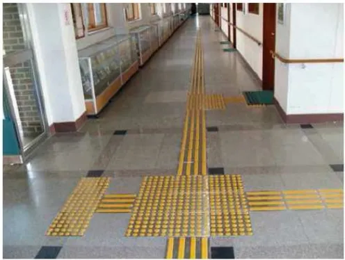
Figure 1 — Braille Blocks: Stop (left) and Walk (right)
Figure 2 — Braille Block Network
Stop blocks and walk blocks are considered as nodes and edges of navigation network, respectively. Consequently a navigation network in indoor space is composed of nodes and edges defined by two types of braille blocks, where nodes and edges may contain additional attributes necessary for indoor maps of visually impaired people. Note that the navigational network is a directed graph since direction is an important property in navigation.
6.2 Three Guiding Instructions – Walk, Stop, and Turn
OGC 15-075r1
Figure 3 — Turning and Walking
6.3 Landmark Information
In order to inform the user of his/her environmental information as discussed in Section 5, Requirement 1, landmark information is also given in addition to navigation instructions. Landmarks includes POIs, obstacles, and other important features. When providing landmark information, we consider two aspects. First, the landmark information must be given early enough before arriving at the relevant position. Second the directional topology information from the current walking edge is also given to user. In figure 4, we assume that the user is walking through the edge e12 from node n1 to node n2, and object A, B, and C are landmarks. Then the landmark information of object A is given as “Object
A is at the right side on the path”, ”Object B is at the left side on the path”, and “Object C
is at the left side over the path”. The directional topology of landmark from the current edge is classified into the following categories;
case 1: left side on the path,
case 2: right side on the path,
case 3: left side over the path, and
Figure 4 – Four Directional Topologies of Landmark
6.4 Landmark Information
We used IndoorGML to provide a framework for the indoor navigation network, which is a fundamental requirement of our prototype. IndoorGML properly supports the braille network and extensions required by VIM service. From this data model, we defined an extension to represent the guiding instructions and landmarks.
7 VIM Data Model
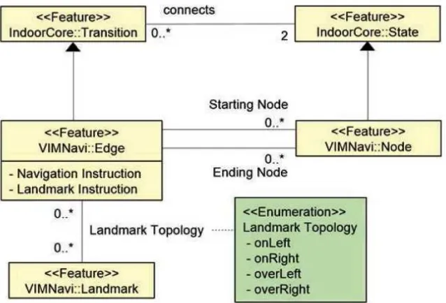
In this section the data model for VIM is presented. The data model is defined as an extension of the IndoorGML Core module reflecting the design concepts that we investigated in Section 6. The UML diagram of the extension is shown in figure 5.
K Edge-based Instruction: Navigation instructions may be associated with either nodes or edges in a navigation network. Since the movements of users are more properly reflected by edges than nodes, we assign the information about navigation instruction to edges. Each edge of the network contains information for voice instruction(s) for navigation and landmarks. Therefore, if a routing path between two positions in indoor space is found, we are given a sequence of edges (e1, e2, ..., ek), where each edge in the sequence contains proper voice navigation
instructions and landmarks.
K Directed Graph: Since voice navigation instructions should be given depending on the walking direction, the navigation network is defined as a directed graph. A single edge in braille block network is therefore split as shown in Figure 6. When making a navigation network, we need to pay attention on each intersection and turning node. For example in figure 6 we see that two turning actions happen at node n1, left turn from e2 to e1, and right turn from the opposite direction. As
previously discussed, any navigation instruction on action should be associated with an edge and node n1 must be split into n11 and n12 and two edges e31 and e32
OGC 15-075r1
Figure 5 — Extension of IndoorGML Core Module for VIM
Figure 6 — Splitting Nodes and Edges
8 Implementation
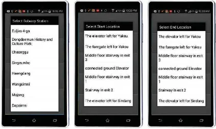
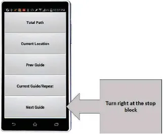
VIM starts with specifying the site name, starting and destination points as shown in Figure 8. Then VIM provides a sequence of navigation guiding instructions for the routing path and user can listen to the instruction of each edge of the network as shown in Figure 9. It also allows users to repeat the instructions.
OGC 15-075r1
Figure 8 – User-Interface to Select Source and Destination (in text)
Figure 9 – A Sample of Voice Route Instruction
9 Conclusion
In this paper, we presented a prototype and design concepts for a voice-based indoor navigation map service. In considering the requirements for indoor navigation for visually impaired people, a prototype called VIM (Voice-based Indoor Map) was developed. The main features of the prototypes are as follows;
K indoor navigation using braille block networks
K voice-based instruction by TalkBack of Android OS, and
K data model extended from IndoorGML Core Module.
Bibliography
[1] BlindSquare, http://blindsquare.com/.
[2] OGC, IndoorGML, http://www.opengeospatial.org/standards/indoorgml
[3] H. G. Ryu, T. H. Kim, and K.J. Li, Indoor Navigation Map for Visually Impaired People, In the Sixth ACM SIGSpatial Workshop on Indoor Spatial Awareness (ISA 2014), pages 32-35, 2014
[4] M. Bousbia-Salah and M. Fezari. A navigation tool for blind people. In Innovations and Advanced Techniques in Computer and Information Sciences and Engineering, pages 333– 337. Springer, 2007.
[5] J. M. Loomis, R. G. Golledge, and R. L. Klatzky. Navigation system for the blind: auditory display modes and guidance. Presence: Teleoperators and Virtual
Environments, 7(2):193– 203, 1998.
[6] F. Mata, A. Jaramillo, and C. Claramunt. A mobile navigation and orientation system for blind users in a metrobus environment. In Web and Wireless Geographical Information Systems, pages 94– 108. Springer, 2011.
[7] S. Watanabe, K. Kaji, and N. Kawaguchi. A proposal of landmark-concious voice navigation. In The Sixth International Conference on Mobile Computing and Ubiquitous Networking (ICMU 2012), pages 56– 61, 2012.
[8] Android TalkBack,
http://developer.android.com/guide/topics/ui/accessibility/apps.html
[9] OpenStreetMap, http://www.openstreetmap.org
OGC 15-075r1
Revision history
Date Release Editor Primary clauses
modified
Description
Aug. 20, 2014 Hyung-Gyu Ryu, Taehoon Kim
Version published in [8]
Aug. 24 2015 1.0 Ki-Joune Li, Hack-Cheol Kim
Modification for OGC ER
