PROFESSIONAL
Android™ Sensor Programming
INTRODUCTION . . . .xxvii
⊲ PART I
LOCATION SERVICES
CHAPTER 1 Introducing the Android Location Service . . . 3CHAPTER 2 Determining a Device’s Current Location . . . 11
CHAPTER 3 Tracking Device Movement . . . 27
CHAPTER 4 Proximity Alerts . . . 45
⊲ PART II
INFERRING INFORMATION FROM PHYSICAL SENSORS
CHAPTER 5 Overview of Physical Sensors . . . 65CHAPTER 6 Errors and Sensor Signal Processing . . . 103
CHAPTER 7 Determining Device Orientation . . . 121
CHAPTER 8 Detecting Movement . . . .147
CHAPTER 9 Sensing the Environment . . . 161
CHAPTER 10 Android Open Accessory . . . 189
⊲ PART III SENSING THE AUGMENTED, PATTERN-RICH EXTERNAL
WORLD
CHAPTER 11 Near Field Communication (NFC) . . . 219CHAPTER 12 Using the Camera . . . 255
CHAPTER 13 Image-Processing Techniques . . . 281
CHAPTER 14 Using the Microphone . . . 303
⊲ PART IV SPEAKING TO ANDROID
CHAPTER 15 Designing a Speech-Enabled App . . . 333CHAPTER 16 Using Speech Recognition and Text-To-Speech APIs . . . 349
CHAPTER 17 Matching What Was Said . . . 407
CHAPTER 18 Executing Voice Actions . . . 441
CHAPTER 19 Implementing Speech Activation . . . .471
PROFESSIONAL
PROFESSIONAL
Android™ Sensor Programming
Indianapolis, IN 46256
www.wiley.com
Copyright © 2012 by John Wiley & Sons, Inc., Indianapolis, Indiana
Published simultaneously in Canada
ISBN: 978-1-118-18348-9 ISBN: 978-1-118-22745-9 (ebk) ISBN: 978-1-118-24045-8 (ebk) ISBN: 978-1-118-26505-5 (ebk)
Manufactured in the United States of America
10 9 8 7 6 5 4 3 2 1
No part of this publication may be reproduced, stored in a retrieval system or transmitted in any form or by any means, electronic, mechanical, photocopying, recording, scanning or otherwise, except as permitted under Sections 107 or 108 of the 1976 United States Copyright Act, without either the prior written permission of the Publisher, or authorization through payment of the appropriate per-copy fee to the Copyright Clearance Center, 222 Rosewood Drive, Danvers, MA 01923, (978) 750-8400, fax (978) 646-8600. Requests to the Publisher for permission should be addressed to the Permissions Department, John Wiley & Sons, Inc., 111 River Street, Hoboken, NJ 07030, (201) 6011, fax (201) 748-6008, or online at http://www.wiley.com/go/permissions.
Limit of Liability/Disclaimer of Warranty: The publisher and the author make no representations or warranties with respect to the accuracy or completeness of the contents of this work and specifi cally disclaim all warranties, including without limitation warranties of fi tness for a particular purpose. No warranty may be created or extended by sales or promotional materials. The advice and strategies contained herein may not be suitable for every situation. This work is sold with the understanding that the publisher is not engaged in rendering legal, accounting, or other professional services. If professional assistance is required, the services of a competent professional person should be sought. Neither the publisher nor the author shall be liable for damages arising herefrom. The fact that an organization or Web site is referred to in this work as a citation and/or a potential source of further information does not mean that the author or the publisher endorses the information the organization or Web site may provide or recommendations it may make. Further, readers should be aware that Internet Web sites listed in this work may have changed or disappeared between when this work was written and when it is read.
For general information on our other products and services please contact our Customer Care Department within the United States at (877) 762-2974, outside the United States at (317) 572-3993 or fax (317) 572-4002.
Wiley publishes in a variety of print and electronic formats and by print-on-demand. Some material included with standard print versions of this book may not be included in e-books or in print-on-demand. If this book refers to media such as a CD or DVD that is not included in the version you purchased, you may download this material at http:// booksupport.wiley.com. For more information about Wiley products, visit www.wiley.com.
Library of Congress Control Number: 2012936847
For Tanya and Madison, my inspiration!!!
—G.M.
To Sabrina, Abigail and Elizabeth...I love you.
ABOUT THE AUTHORS
GREG MILETTE is a professional Android developer and founder of Gradison Technologies, an app development company. He enjoys building practical apps like Digital Recipe Sidekick and contribut-ing to StackOverfl ow.
ADAM STROUD is the lead developer for the Android version of RunKeeper. He is a self-proclaimed “phandroid” and is an active participant in the Android virtual community on StackOverfl ow and Android Google groups.
ABOUT THE CONTRIBUTORS
DAVID N. HUTCHISON (http://davidnhutch.com) was born and raised in New Zealand, and is cur-rently a PhD candidate in physics at Cornell University, where he is developing next-generation inertial sensors. He loves to hack up microcontroller-enabled gadgets in the machine shop, ride his motorcycle, and start companies. David wrote Chapters 5 and 6, and contributed to Chapters 7 and 10.
JON WEBB, the developer of Jon’s Java Imaging Library, has been developing software professionally for over three decades. He enjoys programming image processing on Android as it brings back fond memories of his early days. Jon wrote Chapters 12 and 13.
EXECUTIVE EDITOR
Robert Elliot
PROJECT EDITOR
Brian Herrmann
TECHNICAL EDITOR
Jim Steele
PRODUCTION EDITOR
Christine Mugnolo
COPY EDITOR
Kimberly A. Cofer
EDITORIAL MANAGER
Mary Beth Wakefi eld
FREELANCER EDITORIAL MANAGER
Rosemarie Graham
ASSOCIATE DIRECTOR OF MARKETING
David Mayhew
MARKETING MANAGER
Ashley Zurcher
BUSINESS MANAGER
Amy Knies
PRODUCTION MANAGER
Tim Tate
VICE PRESIDENT AND EXECUTIVE GROUP PUBLISHER
Richard Swadley
VICE PRESIDENT AND EXECUTIVE PUBLISHER
Neil Edde
ASSOCIATE PUBLISHER
Jim Minatel
PROJECT COORDINATOR, COVER
Katie Crocker
PROOFREADER
Josh Chase, Word One New York
INDEXER
Robert Swanson
COVER DESIGNER
Ryan Sneed
COVER IMAGE
ACKNOWLEDGMENTS
WE WOULD LIKE TO THANK David Hutchinson, Pearl Chen, and Jon Webb for providing content and guidance throughout the process of authoring this book. Their expertise in physics, AOA, NFC, and image processing allowed us to describe some exciting ways to use Android in a level of detail we would have otherwise been unable to achieve.
We would like to thank our editors for inspiring us to write the book and their hard work in making us sound more human-like and less like little green robots.
CONTENTS
INTRODUCTION xxvii
PART I: LOCATION SERVICES
CHAPTER 1: INTRODUCING THE ANDROID LOCATION SERVICE 3
Methods Used to Determine Location
3
GPS Provider 4
How It Works 4
GPS Improvements 5
Limitations 6
Controlling GPS 7
Network Provider 8
Using Wireless Network Access Points 8
Using Cell IDs 9
Summary 10
CHAPTER 2: DETERMINING A DEVICE’S CURRENT LOCATION 11
Know Your Tools
12
LocationManager 12 LocationProvider 13 Location 13 Criteria 13 LocationListener 15
Setting up the Android Manifest
15
Determining the Appropriate Location Provider
15
GPS Location Provider 16
Network Location Provider 16
Passive Location Provider 16
Accuracy versus Battery Life 17
Receiving Location Updates
18
Receiving Location Updates with a LocationListener 18 Receiving Location Updates with a Broadcast Intent 18
Implementing the Example App
18
Implementing LocationListener 18
xvi
onProviderDisabled() and onProviderEnabled() 19
onStatusChanged() 20
Obtaining a Handle to LocationManager 20
Requesting Location Updates 23
Cleaning up After Yourself 25
Launching the Location Settings Activity 25
Summary 26
CHAPTER 3: TRACKING DEVICE MOVEMENT 27
Collecting Location Data
28
Receiving Location Updates with a Broadcast Receiver 28
Extending BroadcastReceiver 29
Registering the BroadcastReceiver with Android 30
Requesting Location Updates with a PendingIntent 32
One Intent, Multiple Receivers 33
Why Not Use a Service? 34
Viewing the Tracking Data
35
Google Map Library Components 36
MapView 37 OverlayItem 37 ItemizedOverlay 38 MapActivity 40
Filtering Location Data
40
Continuous Location Tracking and Battery Life
43
Reducing Location Update Frequency 43
Limiting Location Providers 44
Summary 44
CHAPTER 4: PROXIMITY ALERTS 45
App Structure
45
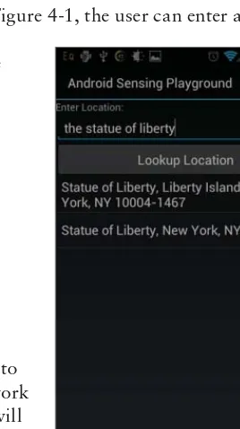
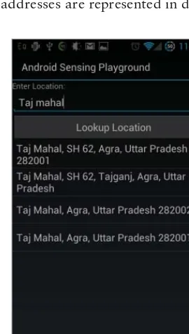
Geocoding 46 android.location.Geocoder 46
Reading the Geocoded Response 48
Setting a Proximity Alert 50
Responding to a Proximity Alert 53
Proximity Alert Limitations
55
Battery Life 55
Permissions 56
CONTENTS
ProximityAlertService 56
Summary 61
PART II: INFERRING INFORMATION FROM PHYSICAL SENSORS
CHAPTER 5: OVERVIEW OF PHYSICAL SENSORS 65
Defi nitions
66
Android Sensor API
68
SensorManager 68 Sensor 68
Sensor Rates 69
Sensor Range and Resolution 70
SensorEventListener 71 SensorEvent 71
Sensor List 72
The Manifest File 72
SensorListActivity 73 SensorSelectorFragment 74 SensorDisplayFragment 76
Sensing the Environment
84
Sensor.TYPE_LIGHT 84 Sensor.TYPE_PROXIMITY 85 Sensor.TYPE_PRESSURE 86
Absolute Altitude 87
Relative Altitude 87
Mean Sea-Level Pressure (MSLP) 87
Where to Find MSLP 88
Sensor Units 88
Sensor Range 88
Common Use Cases 88
Sensor.TYPE_RELATIVE_HUMIDITY 89 Sensor.TYPE_AMBIENT_TEMPERATURE 89 Sensor.TYPE_TEMPERATURE 89
Sensing Device Orientation and Movement
90
Coordinate Systems 90
Global Coordinate System 91
Device Coordinate System 91
Angles 91 Sensor.TYPE_ACCELEROMETER, .TYPE_GRAVITY, and
xviii
Sensor Units and Resolution 93
Sensor.TYPE_GYROSCOPE 94
Sensor Units 94
Sensor Range 94
Sensor.TYPE_MAGNETIC_FIELD 94
Sensor Units, Range, and Resolution 95
Sensor.TYPE_ROTATION_VECTOR 97 SensorManager.getOrientation() 98 SensorManager.getInclination() 101
Sensor Fusion Schemes 101
Summary 102
CHAPTER 6: ERRORS AND SENSOR SIGNAL PROCESSING 103
Defi nitions
104
Accuracy and Precision 104
Types of Errors 105
Human Error, Systematic Error, and Random Error 105 Noise 105 Drift 105
Zero Off set (or “Off set,” or “Bias”) 105
Time Delays and Dropped Data 105
Integration Error 106
Techniques to Address Error 107
Re-zeroing 107 Filters 107
Sensor Fusion 107
Filters 107
Low-Pass 107Weighted Smoothing 108
Simple Moving Average (SMA) 108
Choosing the Smoothing Parameter 111
Averaging: Smoothness vs. Response Time 111
Simple Moving Median (SMM) 111
High-Pass 111
Inverse Low-Pass Filter 112
Bandpass 113
Introducing Kalman Filters 114
A Better Determination of Orientation
by Using Sensor Fusion
115
CONTENTS
Proprietary Sensor Fusion 116
Simple Sensor Fusion: The Balance Filter 117
Summary 119
CHAPTER 7: DETERMINING DEVICE ORIENTATION 121
Previewing the Example App
121
Determining Device Orientation
122
Gravity Sensor 123
Accelerometer and Magnetometer 123
Gravity Sensor and Magnetometer 124
Rotation Vector 124
Implementation Details 125
Processing Gravity Sensor Data 130
Processing Accelerometer and Magnetic Field Data 130
Processing Rotation Vector Data 132
Notifying the User of Orientation Changes 135
NorthFinder 143
Summary 146
CHAPTER 8: DETECTING MOVEMENT 147
Acceleration Data
148
Accelerometer Data 148
Linear Acceleration Sensor Data 150
Data While Device Is in Motion 150
Total Acceleration 153
Implementation 153
DetermineMovementActivity 153 AccelerationEventListener 156Summary 159
CHAPTER 9: SENSING THE ENVIRONMENT 161
Barometer vs. GPS for Altitude Data
162
Example App Overview
162
Implementation Details 163
GPS-Based Altitude 169
Barometric Pressure–Based Altitude 170
Relative Altitude 177
xx
CHAPTER 10: ANDROID OPEN ACCESSORY 189
A Short History of AOA
189
USB Host Versus USB Accessory 190
Electrical Power Requirements 190
Supported Android Devices 190
The Android Development Kit (ADK)
191
Hardware Components 194
Software Components 195
AOA Sensors versus Native Device Sensors
196
AOA Beyond Sensors
196
AOA Limitations
196
AOA and Sensing Temperature
197
Implementation 198 Requirements 198
Getting Started with the Arduino Software 198
Arduino Sketch 199
Android Code 205
Communication between Arduino and Android 208
Taking an Android Accessory to the Consumer Market
215
Summary 216
PART III: SENSING THE AUGMENTED, PATTERN-RICH EXTERNAL WORLD
CHAPTER 11: NEAR FIELD COMMUNICATION (NFC) 219
What Is RFID?
220
What Is NFC?
222
The NDEF Data Format 223
How and Where to Buy NFC Tags 224
NDEF-compatible NFC Tags 224
Storage Size versus Price versus Security Trade-off 224
Write Protection 226
Form Factor 226
Retailers 227
General Advantages and Disadvantages of NFC 227
Low Power and Proximity Based 228
Small, Short Data Bursts 228
Singular Scanning 229
Security 229
CONTENTS
Android-specifi c Advantage: Intents 229
Required Hardware 230
Building an Inventory Tracking System
230
The Scenario 230
The NFC Inventory Demonstration App 230
Enabling NFC in the Settings 231
Debugging Your Tags with Apps 232
Android APIs
233
In Your AndroidManifest.xml File 233
Permissions and Minimum API Level 233
Intent Filters 233
Custom MIME Type Intent Filters 234
URI-based Intent Filters 235
In Your Main Activity Class 236
NfcManager 237
NfcAdapter 237
Foreground Dispatching 237
Foreground NDEF Push 241
Reacting to an NDEF Tag 241
NdefMessage and NdefRecord 243
Parsing and Reading NDEF Tags 245
Getting Ready to Write to a Tag 246
Writing to the Tag 248
Putting it All Together 250
Future Considerations
251
NFC N-Mark 251
Peer-to-Peer NFC Sharing 251
Peer-to-Peer Android APIs 252
Go Forth and NFC!
253
Summary 254
CHAPTER 12: USING THE CAMERA 255
Using the Camera Activity
255
Controlling the Camera with Your Own Activity 256
Claiming and Releasing a Camera 257
The Preview View 258
Controlling the Camera 261
xxii
Switching Cameras 264
Flash 264
Other Camera Parameters 265
Creating a Simple Barcode Reader
267
Understanding Barcodes 267
Parity and Implied First Digit 269
The Check Digit 270
Right Half of the Barcode 271
Autofocus 272 Using the Camera Preview Image and Detecting the Barcode 273 Debugging Image Processing Programs on Android 275
Detecting the Barcode 276
Summary 279
CHAPTER 13: IMAGE-PROCESSING TECHNIQUES 281
The Structure of Image-Processing Programs
281
The Image-Processing Pipeline 281
Common Image-Processing Operations 282
Image-to-Image Operations 282
Image-to-Object Operations 284
Jon’s Java Imaging Library (JJIL) 284
Image 285 PipelineStage 285 Sequence 288 Ladder 289
JJIL and Detecting the Android Logo 291
Choose the Right Image Size 293
Improving Reliability in Image Processing 296
Detecting Faces
299
Image-Processing Resources
300
Summary 301
CHAPTER 14: USING THE MICROPHONE 303
Introducing the Android Clapper
303
Using MediaRecorder to Analyze Maximum Amplitude
304
Recording Maximum Amplitude 305
Asynchronous Audio Recording 310
Implementing a Clapper
312
CONTENTS
Setting Audio Input Parameters 315
Preparing AudioRecord 316
Recording Audio 317
Using OnRecordPositionUpdateListener 317
Using Loud Noise Detection
323
Using Consistent Frequency Detection
324
Estimating Frequency 325
Implementing the Singing Clapper 327
Summary 329
PART IV: SPEAKING TO ANDROID
CHAPTER 15: DESIGNING A SPEECH-ENABLED APP 333
Know Your Tools
334
User Interface Screen Flow
336
Voice Action Types
337
Voice User Interface (VUI) Design
338
Deciding Appropriate Tasks for Voice Actions 339
Designing What the App and Users Will Say 340
Constrain Speech Input to Increase Accuracy 340
Train Users to Know What They Can Say 340
Prompt the Users so They Know What to Say 341
Confi rm Success and Help Users Recover from Errors 342 Help Users Recover from Accidental Speech Activation 343
Teach Users Proper Speech Hygiene 344
Use Menus Cautiously 344
After the Design 345
Testing Your Design
346
Summary 347
References 347
CHAPTER 16: USING SPEECH RECOGNITION
AND TEXT-TO-SPEECH APIS 349
Text-To-Speech 349
Initialization 350Initialization with Locale 351
Check TTS Data Action 361
Speaking 366
xxiv
Speech Recognition
377
Initializing 377
Using the RecognizerIntent 382
The Speech Recording Process 384
Confi guring and Processing the Result 385
RecognizerIntent Use Cases 386
Implementation 391 Direct Speech Recognition Using SpeechRecognizer 403
Summary
405
CHAPTER 17: MATCHING WHAT WAS SAID 407
Parts of a Voice Command
407
Word Spotting
409
Indexing to Improve Word Spotting 411
Stemming 412
Phonetic Indexing 414
Matching Command Words in Persistent Storage
418
SQLite Full Text Search 418
Using the LIKE Operator 419
Using the FTS MATCH Operator 420
Implementing FTS 421
Word Searching with Lucene 426
Multi-part Commands
431
Ignoring Potential Collisions 432
Considering Ordering 434
Using a Grammar
438
Summary 438
CHAPTER 18: EXECUTING VOICE ACTIONS 441
Food Dialogue VUI Design
442
Defi ning and Executing Voice Actions
443
Executing VoiceActionCommands
448
Implementing an AlertDialog for VoiceActions
451
Implementing Multi-Turn Voice Actions
455
Implementing Multi-Turn AddFood 455
Implementing Multi-Turn RemoveFood 459
Making a Best Guess
461
Relaxing Strictness Between Commands 463
Making an Educated Guess 464
CONTENTS
Determining Not a Command 468
Determining Inaccurate Recognition 469
Not Understanding 469
Summary 469
CHAPTER 19: IMPLEMENTING SPEECH ACTIVATION 471
Implementing Speech Activation
472
Starting Speech Recognition 473
Implementing Speech Activation within an Activity 475 Activating Speech Recognition with Movement Detection 479 Activating Speech Recognition with the Microphone 481 Activating Speech Recognition with
Continuous Speech Recognition 483
Activating Speech Recognition with NFC 487
Implementing Persistent Speech Activation
488
Using a Service for Persistent Speech Activation 489
Summary 494
INTRODUCTION
ANDROIDS ARE ALIVE. THEY CAN LOCATE THEMSELVES, see, listen, and understand speech. They can sense radio signals and detect orientation, movement, and environmental properties. Can your com-puter do all of that?
The availability of sensors is one feature Android devices have that makes them different from other computers. Without sensors, an Android device is just an underpowered, mobile web browser with a screen that is too small and has an awkward input mechanism.
Sensors also allow apps to do amazing things. For example, sensors can help save users from pain-fully slow manual input and manipulation, and sensors can help users do tasks that they could never do before. Because of this, it may be essential for an app to incorporate sensors to be successful.
Sensors will continue to be an important part of the Android platform. As the hardware specifi ca-tions of Android devices improve, so do the number of available sensors and their quality. While this happens, users will continue to expect apps to use any existing and new sensors when possible. Therefore, using Android’s sensors is a crucial skill for any Android programmer to master. This book gives you the knowledge and code you need to develop this skill and make great apps that use sensors.
PROGRAMMING WITH ANDROID SENSORS
Writing apps that use Android’s sensors involves understanding the sensing capabilities of an Android device, selecting which sensors to use in an app, and implementing an app that can acquire sensor data and interpret it.
Android’s Sensing Capabilities
An Android device can have a wide variety of sensors. This book uses a defi nition of sensor that incorporates many of an Android device’s capabilities. In this book a sensor is:
A capability that can capture measurements about the device and its external environment.
xxviii
This book describes how to program apps that process information from the following sensor types:
‰ Location sensors: Determine a device’s location using a variety of sensors including GPS.
‰ Physical sensors: Detect device-specifi c properties such as orientation, acceleration, and rota-tion and environmental properties such as light, magnetic fi eld, and barometric pressure.
‰ NFC scanner: Detects near fi eld communication (NFC) tags and shares data with other NFC-enabled Android devices.
‰ Camera: Collects visual images.
‰ Microphone: Records audio.
‰ Speech recognition: Converts audio to text using a combination of recorded audio from the microphone and recognition algorithms.
‰ External sensors: Any sensor connected using the Android Open Accessory (AOA) mechanism.
Selecting Sensing Tasks
Understanding how the sensors work helps you know which of your app’s tasks can benefi t from sensor-related input. It also helps you interpret the sensors’ performance under various conditions and know their limitations. For example:
‰ Location: Knowing how various location sensors work, as described in Chapter 1, may lead you expect poor accuracy while a device is indoors.
‰ Physical sensors: Knowing information about what the physical sensors measure, as discussed in Chapter 5, can help you understand what inferences an app can reasonably make with the sensor output.
Using API Boilerplate
In any app, acquiring sensor data requires similar code. Each kind of data requires different boil-erplate. In many cases, is not trivial to initialize the API and acquire the data. This book provides code examples and libraries to help make it easier to implement. Some examples of the diffi culties involved in using the APIs include:
‰ Camera: Before an app can analyze an image, it must acquire the image from the camera. However, using a device’s camera requires handling device rotation, hardware constraints, and using the Camera and View objects properly. Chapters 12 and 13 describe abstract classes that handle these details.
‰ NFC: Using NFC involves understanding the various steps needed to read and write NFC tags and what data to put in them. Chapter 11 explains a complete code example that is easy to adapt.
Collecting Sensor Data
INTRODUCTION
‰ Location: Location tracking is a common use of location sensors. Some apps need to per-sistently track location while an app performs other tasks. Chapter 3 describes several approaches for implementing location tracking reliably.
‰ Speech recognition: To acquire speech recognition results an app needs to have other components besides actually running the speech recognizer. An app also needs to allow the user to activate speech and mediate turn taking between when the user can speak and when the app is listening. Part 4 describes all the necessary software components you need to implement complete voice commands.
Interpreting Sensor Data
After an app has collected some sensor data, it then needs to analyze the data to achieve a desired effect. Each sensor requires different analysis algorithms. Some examples include:
‰ Physical sensors: Interpreting data from physical sensors involves calculations to convert raw data into usable values and algorithms to help detect changes and ignore noise. Part 2 describes how.
‰ Camera: Processing images from the camera involves setting up an image-processing pipeline. An app must reduce the large image that the camera collects to a manageable size that would otherwise be too large to fi t in memory or too slow to process. Then the app needs to trans-form the collected image in various ways to detect something within it.
‰ Microphone: Analyzing audio recordings involves signal-processing algorithms. Chapter 14 describes algorithms for volume detection and frequency estimation.
‰ Speech recognition: Executing voice commands involves matching what the user said with command words using text search methods. Chapter 17 describes methods to improve matching success.
Applications in This Book
This book presents applications that utilize sensors for specifi c purposes. The applications provide practical code components that solve common problems.
Some example applications in this book include:
‰ Chapter 3: Using a database and a BroadcastReceiver to implement persistent, reliable location tracking.
‰ Chapter 4: Using a service to implement an effi cient proximity alert that conserves battery life.
‰ Chapter 7: Using various physical sensors to determine if the device is face up or face down.
‰ Chapter 7: Using the rotation vector sensor to implement features needed for an augmented reality app.
‰ Chapter 8: Using the acceleration sensors to detect movement.
xxx
‰ Chapter 10: Using AOA to collect data from an external temperature sensor.
‰ Chapter 11: Using NFC tags with custom data to track inventory.
‰ Chapter 13: Using the camera to detect the Android logo.
‰ Chapter 14: Using the microphone to implement a clapper by detecting loud noises and a singing tone.
‰ Chapters 17 and 18: Using speech recognition and Text-to-Speech to implement voice com-mands that query and manipulate data in a food database.
ADVANCED ANDROID PROGRAMMING
This book is for developers familiar with programming for Android. It assumes you understand basic Android concepts like Activities and Intents but may have not have used the sensor-related APIs. It also assumes you understand some math concepts and fully explains any physics concepts you need to know.
Additionally, this book focuses on programming sensors. This focus allows suffi cient space to fully describe how to process each kind of data and go beyond explaining simple uses of the APIs.
Beyond sensor programming, this book describes techniques that are applicable in any app. For example, the chapters in this book show you how to use BroadcastReceivers, Services,
AsyncTasks, and databases for various tasks.
START SENSING!
Apps can utilize sensors to create amazing features that are unique and save a user’s time. Android’s sensing capabilities will only improve over time and continue to be an important component in many apps. This book arms you with the knowledge and code you need to use these capabilities to create great apps.
ANDROID SENSING PLAYGROUND APP
This book comes with an app called Android Sensing Playground. The app enables you to execute most of the applications and example code from this book and also utilize “playgrounds” which allow you to observe the relevant APIs working under various parameter settings.
Download the app from Google Play here: https://play.google.com/store/apps/ details?id=root.gast.playground.
GREAT ANDROID SENSING TOOLKIT (GAST)
INTRODUCTION
SOURCE CODE
As you work through the examples in this book, you may choose either to type in all the code man-ually, or to use the source code fi les that accompany the book. All the source code used in this book is available for download at www.wrox.com. When at the site, simply locate the book’s title (use the Search box or one of the title lists) and click the Download Code link on the book’s detail page to obtain all the source code for the book. Code that is included on the website is highlighted by the following icon:
Listings include the fi lename in the title. If it is just a code snippet, you’ll fi nd the fi lename in a code note such as this:
code snippet fi lename
Because many books have similar titles, you may fi nd it easiest to search by ISBN; this book’s ISBN is 978-1-118-18348-9
Once you download the code, just decompress it with your favorite compression tool. Alternately, you can go to the main Wrox code download page at www.wrox.com/dynamic/books/download .aspx to see the code available for this book and all other Wrox books.
CONVENTIONS
To help you get the most from the text and keep track of what’s happening, we’ve used a number of conventions throughout the book.
Warnings hold important, not-to-be-forgotten information that is directly rel-evant to the surrounding text.
Notes indicate notes, tips, hints, tricks, and asides to the current discussion.
TRY THIS
xxxii
As for styles in the text:
‰ Wehighlightnew terms and important words when we introduce them.
‰ We show keyboard strokes like this: Ctrl+A.
‰ We show fi le names, URLs, and code within the text like so: persistence.properties.
‰ We present code in two different ways:
We use a monofont type with no highlighting for most code examples.
We use bold to emphasize code that is particularly important in the present context or to show changes from a previous code snippet.
ERRATA
We make every effort to ensure that there are no errors in the text or in the code. However, no one is perfect, and mistakes do occur. If you fi nd an error in one of our books, like a spelling mistake or faulty piece of code, we would be very grateful for your feedback. By sending in errata you may save another reader hours of frustration, and at the same time you will be helping us provide even higher quality information.
To fi nd the errata page for this book, go to www.wrox.com and locate the title using the Search box or one of the title lists. Then, on the Book Search Results page, click on the Errata link. On this page, you can view all errata that has been submitted for this book and posted by Wrox editors.
A complete book list including links to errata is also available at www.wrox.com/ misc-pages/booklist.shtml.
If you don’t spot “your” error on the Errata page, click on the Errata Form link and complete the form to send us the error you have found. We’ll check the information and, if appropriate, post a message to the book’s errata page and fi x the problem in subsequent editions of the book.
P2P.WROX.COM
For author and peer discussion, join the P2P forums at p2p.wrox.com. The forums are a web-based system for you to post messages relating to Wrox books and related technologies and interact with other readers and technology users. The forums offer a subscription feature to e-mail you topics of interest of your choosing when new posts are made to the forums. Wrox authors, editors, other industry experts, and your fellow readers are present on these forums.
At p2p.wrox.com, you will fi nd a number of different forums that will help you, not only as you read this book, but also as you develop your own applications. To join the forums, just follow these steps:
INTRODUCTION
3.
Complete the required information to join, as well as any optional information you wish to provide, and click Submit.4.
You will receive an email with information describing how to verify your account and complete the joining process.You can read messages in the forums without joining P2P, but in order to post your own messages, you must join.
Once you join, you can post new messages and respond to messages other users post. You can read messages at any time on the web. If you would like to have new messages from a particular forum e-mailed to you, click the Subscribe to this Forum icon by the forum name in the forum listing.
PART I
Location Services
⊲
CHAPTER 1:
Introducing the Android Location Service
⊲
CHAPTER 2:
Determining a Device’s Current Location
⊲
CHAPTER 3:
Tracking Device Movement
1
Introducing the Android
Location Service
WHAT’S IN THIS CHAPTER?
‰ Providing overview of how location information is provided in Android
‰ Presenting an overview of GPS
‰ Discussing why A-GPS is used in Android
‰ Providing an overview of the network location provider
Location information is becoming increasingly important in the world of mobile develop-ment. Apps that were once location agnostic now make use of location information to provide a richer user experience. Being able to combine a simple web search engine with up-to-the-minute location information allows Android devices to provide a level of functionality that was previously not possible. The capability to easily retrieve and provide location data to apps is becoming a major feature of today’s mobile platforms. Android provides this functionality with its location service.
Android’s location service provides access to facilities that can be used to determine a device’s current location. This information can be used for a wide variety of functions and can allow a device and the software that runs on it to have a better understanding of its surroundings.
METHODS USED TO DETERMINE LOCATION
The following sections give some high-level explanations as to how the different location acquisition methods work. Although an app has little control over how the providers work, it can decide which location provider to use. Understanding how each provider works goes a long way in understanding its limitations and characteristics.
GPS Provider
The Global Positioning System (GPS) uses a system of satellites orbiting the planet to help a receiver (an Android handset in this case) determine its current location. The term GPS refers to the entire GPS system, which consists of satellites, receivers, and the control stations that monitor and adjust it. The receiver that is located in the phone is useless without the rest of the system.
How It Works
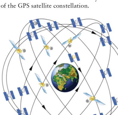
In general, a GPS receiver uses information from the GPS satellites orbiting the earth to calculate its current location. The GPS system contains 27 satellites that continually orbit the earth, transmitting information to would-be receivers. Each satellite follows a defi ned path, ensuring that at least four satellites are “visible” from any point on earth at any given time. Being able to have a “line of sight” to at least four satellites is necessary to determine location using GPS. Figure 1-1 shows a depiction of the GPS satellite constellation.
Source: http://gps.gov/multimedia /images
FIGURE 1-1: GPS satellite constellation
Methods Used to Determine Location
x
5To calculate its location, a GPS receiver must be able to determine its distance from multiple satel-lites. It does this using the ephemeris data. Included in the data that is transmitted from the satellite, along with the position data, is the time at which the transmission started. Each GPS satellite con-tains a highly accurate timekeeping mechanism that allows the satellite to keep its time in sync with the rest of the satellites. To produce an accurate location calculation, the GPS satellites and GPS receivers must have their clocks highly synchronized. Even the slightest difference in time can cause large errors when computing location.
Using the transmission start time, the GPS receiver can calculate the time it took for the transmis-sion to be received (the receiver knows when the transmistransmis-sion ended). This calculation is made with the assumption that the radio waves that transmit the data travel at the speed of light in a vacuum (which is not always the case). Using the start time, end time, and a constant for the speed of light, a GPS receiver can calculate the distance of the satellite from the receiver.
Using the distance from multiple satellites, the GPS receiver can triangulate its current location. Essentially, the point at which all the spheres intersect is the location of the receiver. A minimum of three satellites is needed to determine a two-dimensional location (latitude and longitude). Communications from additional satellites allow a GPS receiver to determine additional positional information such as altitude. A GPS receiver will not limit itself to only four satellites. In general as the number of satellites from which the receiver can receive data increases, so does the accuracy of the location (there is an upper limit, however).
GPS is useful for determining current location, but it does have some drawbacks (especially for mobile platforms), one of which is the time it can take to calculate the current position. Before the location can be calculated, multiple satellites must be found. Many satellites are orbiting the earth, but only a handful can be “seen” at any given time because most will be below the horizon and blocked by the earth (remember, a line of sight is needed). The almanac used by the GPS system can provide assistance in determining which satellites should be used for a given location at a given time. However, if the GPS does not have a relatively current almanac, it will need to have the almanac data transmitted by a GPS satellite. This can be a slow process.
GPS Improvements
Although standard GPS can provide accurate location data, the limitations it imposes make it dif-fi cult for mobile devices to use it. To help circumvent some the limitations of standard GPS, modern mobile devices make use of assisted GPS (A-GPS) and possibly simultaneous GPS (S-GPS).
A-GPS
A-GPS uses the mobile network to transmit the GPS almanac along with other pieces of information to a mobile device. This use of the mobile network allows for faster transmission of the almanac, which may lead to faster determination of the device’s current location. In addition, because the almanac contains information about all of the GPS satellites, the device will know the approximate location of the GPS satellites in its line of sight. This will also improve the time it takes to acquire a GPS location.
LISTING 1-1: An example of a GPS confi guration fi le located in /system/etc/gps.conf
NTP_SERVER=north-america.pool.ntp.org
XTRA_SERVER_1=http://xtra1.gpsonextra.net/xtra.bin XTRA_SERVER_2=http://xtra2.gpsonextra.net/xtra.bin XTRA_SERVER_3=http://xtra3.gpsonextra.net/xtra.bin
Listing 1-1 shows that the GPS confi guration fi le can specify the location of the A-GPS data to download (XTRA_SERVER_1,XTRA_SERVER_2, and XTRA_SERVER_3) as well as a Network Time Protocol (NTP) server that can be used to coordinate time (NTP_SERVER). NTP can be used to force coordination of time. This is important because GPS relies heavily on the clocks of a GPS receiver and the GPS satellites being in sync. Although the use of NTP does not guarantee true time syn-chronization down to the millisecond, it does help to prevent large time differences. Because of the numbers used in calculating times, like the speed of light, a small difference in time can lead to large inaccuracies in location calculations.
Though most users can read /system/etc/gps.conf, increased permissions are required to write to the fi le. Generally, users should not need to edit this fi le.
S-GPS
Devices that use standard GPS may use the same hardware to communicate with GPS satellites and make mobile phone calls. This means that only one of these actions can take place at a time. S-GPS addresses this issue by adding additional hardware that allows the GPS radio and the cellu-lar network radio to be operational simultaneously. The ability to have two radios active can speed up GPS data transmission because it allows the data to be received while the cellular network radio is active.
Limitations
Although GPS can provide the most accurate location data, it does have limitations that may be diffi cult to work around. First is the fact that a GPS receiver needs a clear path to a GPS satellite. This means that GPS receivers are unlikely to work indoors, and may even have prob-lems outside in areas where the sky is not visible (such as dense forests). Additionally, because multiple GPS satellites are needed to produce location information, it may take a substantial amount of time to acquire a location. This is exacerbated by that fact that devices may contain low-powered GPS radios. For these reasons, other sources of location information are
sometimes needed.
Methods Used to Determine Location
x
7Controlling GPS
For most cases, GPS should “just work” as far as app developers are concerned. Typically, there will be no reason to interfere with the source of the A-GPS data, or when the A-GPS data should be purged and reinitialized.
However, Android does provide an API for controlling certain aspects of GPS data. The
LocationManager class (which is introduced in detail in the next chapter) contains a sendExtra-Command() method that can be used to manipulate device GPS state. The LocationManager.send-ExtraCommand() method takes three parameters: a string specifying the location provider, the extra command, and a Bundle that provides additional information for performing the command.
At the time of this writing, the GPS location provider supports only three extra commands:
‰ delete_aiding_data
‰ force_time_injection ‰ force_extra_injection
The delete_aiding_data command is used to remove the A-GPS data that has been previously downloaded. It is the only extra command that makes use of the Bundle parameter, which is used to control what A-GPS data should be removed. The Bundle can contain Boolean values with keys to indicate which data to remove. The keys can be any of the following strings:
‰ ephemeris
‰ almanac ‰ position
‰ time
‰ iono
‰ utc
‰ health ‰ svdir ‰ scsteer
‰ sadata
‰ rti
‰ celldb-info
‰ all
Passing a null for the Bundle causes all the A-GPS data to be removed.
The force_extra_injection command causes the A-GPS data to be downloaded from one of the confi gured servers and used by the GPS location provider.
Network Provider
In Android, network-based location can use different methods for determining the location of a device. As of this writing, the network location provider can provide location information using cell towers, or based on wireless network information.
Using Wireless Network Access Points
Providing location information based on wireless network access points is one of the ways that Android supports location resolution with the network provider. Although it does require that the Wi-Fi radio is active, the Wi-Fi radio often consumes less battery power than the GPS hardware.
How It Works
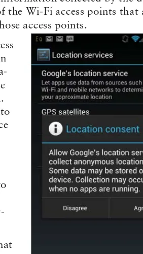
Wi-Fi-based location detection works by having a device track what Wi-Fi access points it can detect and the current signal strength of those access points. The device then makes a query to the Google location service (which is different from the Android location service), which provides location data based on the Wi-Fi information. The Wi-Fi information collected by the device includes the mandatory access control (MAC) addresses of the Wi-Fi access points that are in range and the strength of the signal being received from those access points.
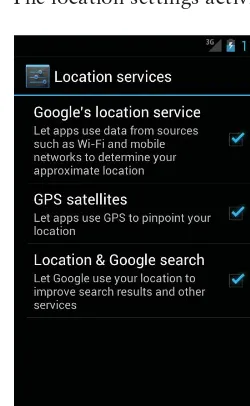
To provide location information based on visible Wi-Fi access points, the Google location service must obtain information about Wi-Fi access points and their locations. This informa-tion is collected by Android devices when a user enables use of Google’s location service in the Location Settings screen. Figure 1-2 shows the confi rmation screen that is presented to a user when enabling the Google location service as a source of location data.
Pressing Agree on this screen allows the device to record Wi-Fi information as well as current location information (possibly provided by GPS) and transmit this information to Google. This essentially allows Google use each and every Android device as a way to update the Wi-Fi location infor-mation and constantly maintain up-to-date data.
One of the main benefi ts of the Wi-Fi location source is that it allows devices to acquire location information in areas where GPS cannot provide location data. As stated in the previous section, GPS is problematic when used indoors or even in an urban environment where tall buildings can cause signal problems. In contrast, an urban environment may increase the accuracy of Wi-Fi-based location because of the abundance of Wi-Fi networks available to determine a device’s current location.
Methods Used to Determine Location
x
9Limitations
As with GPS, using Wi-Fi networks as a source of location information does have its limitations. First, to determine the location, Wi-Fi networks must be in range. Additionally, the networks must have a publicly broadcasted service set identifi er (SSID) that has not been confi gured to be ignored by Android. Access points that have an SSID that ends in _nomap will not have their information sent to the Google location service.
Additionally, changes to the location of Wi-Fi access points can cause inaccuracies in the location data that is produced. For example, many people now have wireless networks in their homes for daily use. Assuming an Android device has been confi gured to use the Google location service, Android would have sent the access point MAC address and location to the Google location service. If the user were to change the location of that access point (take it to a vacation home, for example), the location service might determine the device to be in the wrong location when the Wi-Fi location source is used.
Although the location service does allow for access point location to be updated via Android devices, Google does not allow users to explicitly set the location of an access point. An Android device will push the information to the location service, which may wait until other devices can confi rm the change before the location service is updated.
Using Cell IDs
In addition to using Wi-Fi information to determine device location, Android can also use the cellular network. The cellular network is used in a similar way as Wi-Fi access points to determine device location.
How It Works
To function properly, a cellular device must be in contact with a cell tower. As a device moves, it may connect to a different cell tower as the signal strength of an approaching cell tower becomes stronger. Knowing the unique ID of the tower that a device is currently connected to, and possibly the towers that a device was previously connected to, can provide insight to where the device is located assuming the location of a given cell tower is known.
Android and the Google location service work together to map cell tower IDs to location data in a way that is similar to Wi-Fi data. Once a device has been confi gured to use the network provider, it collects data on the current cell tower ID in addition to the visible wireless networks. For cell tow-ers, this data includes the cell tower the device is currently connected to and the device’s current GPS location. With this information, the Google location service can develop a “map” of cell towers that includes their locations.
By again allowing Android devices to update cell ID information, the Google location service can maintain a constantly updated store of information that increases in accuracy as the number of entries increases.
device’s current location based on the data it has about the cell tower network. If the IDs of multiple cell towers are sent to the Google location service, it can use triangulation to provide increased loca-tion accuracy. The Google localoca-tion service cannot do this if the device submits only a single cell tower ID.
Limitations
The limitations for using cell tower IDs are similar to the limitations that exist when using Wi-Fi networks to determine location. However, because the location of cell towers is less likely to change than the location of wireless access points, some of the complications that may exist when using Wi-Fi access points are removed.
However, just like Wi-Fi access point data, the Google location service must have data on the cell tower IDs that are sent by a device in order to provide location data.
SUMMARY
2
Determining a Device’s Current
Location
WHAT’S IN THIS CHAPTER?
‰ Introduction to the Android Location API components
‰ Introduction to the diff erent sources of location information in Android
‰ Example usage of the Location API to determine a device’s current location
Mobile app developers often have to determine the device’s current location. Knowing a device’s location enables app developers to add increased functionality to a wide range of apps. Location data is a key component to apps like Google Maps and Google Navigator, and is also used in Google search, Twitter, and Facebook to add another dimension to the data they are already collecting.
For developers who have made the decision to include location data, Android provides a fairly robust API to its location service. Although on the surface this API may seem trivial to use, plenty of details — such as battery life and accuracy of location data — need to be considered.
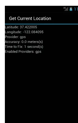
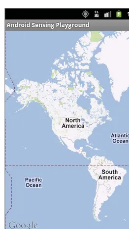
FIGURE 2-1: Current location app
KNOW YOUR TOOLS
This chapter starts the discussion of the location service by fi rst taking a bird’s-eye view of some of the tools that Android has to offer. One of the fi rst things I do when I need to solve a problem is to take a look at what tools I have to work with. For Android, the majority of the classes that you will need when working with location data are located in the android.location package. For the exam-ple app, you will need to use fi ve members of the location package. These just happen to be the fi ve members of that package that you will frequently use when dealing with location data in Android.
Classes:
‰ LocationManager
‰ LocationProvider
‰ Location
‰ Criteria Interfaces:
‰ LocationListener
Figure 2-2 shows a high-level overview of how the location components fi t together. Because these members are so important and used so frequently, the following sections discuss each one in a little more detail.
LocationManager
The main point of entry when using the location service in Android is the LocationManager. The
Know Your Tools
x
13information and when it no longer wants location updates. In addition, the LocationManager pro-vides information about the current state of the location system such as available location providers, enabled location providers, and GPS status information. The LocationManager can also provide the last known (cached) location of the device.
Reads Location Provider requirements
LocationManager Criteria
Notifies with Location Data Enables
LocationListener
Consumes Produces
Location LocationProvider
FIGURE 2-2: Android location components
LocationProvider
LocationProvider is an abstraction for the different sources of location information in Android. Android provides different sources of location data that have drastically different characteristics. Though each provider generates location data differently, they all communicate with an app the same way and provide similar data to an app in the same manner.
Location
The Location class is what encapsulates the actual location data provided to an app from a location provider. It contains the quantifi able data such as latitude, longitude, and altitude. Once an app has received a Location object, it can start the application-specifi c processing on that data.
One important point about the Location class is that, although it has properties for a wide range of location data, not all location providers will populate all the properties. For example, if an app uses a location provider that does not provide altitude, the Location instance will not contain altitude information. The Location class also provides methods that allow an app to check if an instance contains the information (hasAltitude() in this case).
Criteria
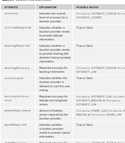
with individual location providers directly. Once instantiated, an app can set/unset attributes on a
Criteria class to refl ect the characteristics of the location providers that it is interested in. Table 2-1 provides the list of the attributes on the Criteria class that can be used to select a location provider.
TABLE 2-1: Location Criteria Attributes
ATTRIBUTE EXPLANATION POSSIBLE VALUES
Determining the Appropriate Location Provider
x
15LocationListener
The LocationListener interface contains a group of callback methods that are called in reaction to changes in a device’s current location or changes in location service state. The LocationManager
enables an app to register/unregister a location listener implementation that can be used to process the changes in state.
There are two ways to receive location updates from the location service: a LocationListener and aPendingIntent. This chapter focuses on using a LocationListener; the use of a PendingIntent
is deferred until the next chapter.
Now that the tools needed to implement the app have been introduced, the following sections dig into the mechanics of requesting and processing the location information.
SETTING UP THE ANDROID MANIFEST
As with many of the services that Android provides, the location service requires an app to declare its intentions to use it in the Android manifest. The Android manifest declaration must defi ne the precision of the location data that will be requested. Like any other Android permission, the end user will be shown the list of requested permissions at install time and will be able to decline instal-lation upon seeing that list. Some users are a little squeamish at the thought of allowing an app to determine their location if it is not clear why the app would need this information. Adding superfl u-ous permissions is a good way to scare users away.
The two permissions that deal with live location data are android.permission.ACCESS_FINE_ LOCATION and android.permission.ACCESS_COARSE_LOCATION. As the names might indicate, the permissions defi ne the level of accuracy that will be provided to an app from the location service. Ultimately, these permissions defi ne which location providers can be used in an app. Because the
android.permission.ACCESS_FINE_LOCATION permission provides more accurate location data, it can be used without explicitly specifying android.permission.ACCESS_COARSE_LOCATION to grant permission for both fi ne-grained and coarse-grained location data. However, android.permission. ACCESS_COARSE_LOCATION only allows for coarse-grained location data to be provided to an app. For the app in this chapter, highly accurate location data is desired. So, the following code snippet is added to AndroidManifest.xml:
<uses-permission android:name="android.permission.ACCESS_FINE_LOCATION" />
Failure to request the correct permissions causes a java.lang.
SecurityException to be thrown at run time when requesting location updates.
DETERMINING THE APPROPRIATE LOCATION PROVIDER
‰ GPS location provider
‰ Network location provider
‰ Passive location provider
An app can declare which location provider to use in one of two ways: by explicitly registering each desired location provider with the LocationManager, or by specifying attributes in a Criteria
object and passing that object to the LocationManager. Using the Criteria object is useful for allowing the user to customize the source of location data at run time. This may be of importance to a user because use of some location providers can cost them money.
GPS Location Provider
The GPS location provider uses orbiting satellites and time to determine the current location of a device, and tends to produce the most accurate location data. However, because it relies on a sepa-rate radio, the GPS provider can also consume more battery power than other location providers. This can be a major issue depending on the length of time an app needs to actively be receiving and processing location data.
In addition to consuming more battery power, the GPS location provider can also take a long time to acquire a fi x (location data). Time to fi rst fi x (TTFF) values of over a minute are common, and can vary drastically from device to device or between different versions of Android. In addition, obtaining a GPS fi x indoors is unlikely because a direct line to the sky is usually required. TTFF is important to pay attention to because it is generally a bad idea to block the user from performing a task while an app is waiting for location data.
Network Location Provider
The network location provider uses two data sources to provide a location fi x: Wi-Fi network loca-tion and cell-tower localoca-tion. The TTFF for the network provider can be substantially less than the TTFF for the GPS provider. However, the network provider produces much less accurate location data. Depending on the needs of an app, it might be worth trading the location accuracy of the GPS provider for the low TTFF values of the network provider. The network provider may also consume less battery power than the GPS provider because it allows the user to leave the GPS radio and (pos-sibly) the Wi-Fi radio off.
Passive Location Provider
The passive location provider allows an app to receive location information without having to explicitly request location update information from the LocationManager. The passive provider provides location updates when another app has explicitly requested location updates with either the GPS or network providers. This allows an app to piggy-back on the location information requested from another app and prevent Android from making a special request for location data.
Determining the Appropriate Location Provider
x
17This implies that an app does not have any control over which other providers are used to receive location updates, or the frequency at which the updates will arrive (the other apps have defi ned this when setting up the LocationManager). Because of this, use of the passive provider mandates the use of the android.permission.ACCESS_FINE_LOCATION permission so that data from both the GPS and network providers can be received. The Location object that is received will contain infor-mation about the source of the location data.
The passive provider is not guaranteed to receive any location updates. If no other apps are receiving location updates, the passive provider will not receive any either. Because of this, the passive provider is generally not appropriate to use when an app is in the foreground and actively interacting with the user. Use the passive location provider to keep application data up to date while running in the background and without explicitly requesting location data.
It is good form for apps to be a “good citizens” on an Android device and remove requests for location updates when they app exit. If an app makes the distinction of closing as opposed to back-grounding (user clicks “back” as opposed to user pressing “home”), then the app should unregister for updates even when using the passive provider.
Accuracy versus Battery Life
The common theme when choosing location providers is deciding between increased accuracy and increased battery consumption. Although most apps that need location data could benefi t from more accurate data, many of them do not truly need the accuracy, especially at the expense of additional battery power.
Table 2-2 provides a summary of the location providers available in Android.
TABLE 2-2: Location Providers
LOCATION PROVIDER REQUIRED PERMISSION BATTERY CONSUMPTION ACCURACY
GPS Provider android.permission.
RECEIVING LOCATION UPDATES
Before getting knee-deep into Java code, one more topic warrants discussion: how an app actually gets notifi ed about location updates. Recall from an earlier discussion that location data can be delivered to an app in two ways: a direct call to a LocationListener, or by a broadcasted Intent. The LocationListener approach is the simpler approach (and the one used for this chapter’s exam-ple app), but the broadcast Intent approach can offer more fl exibility, especially if location update information needs to be provided to more than one application component.
In either case, an app must tell the LocationManager when it is ready to start receiving updates as well as when it no longer wants location updates. How the location updates get sent to an app is defi ned by how an app registers for location updates with the LocationManager.
Receiving Location Updates with a LocationListener
Objects that implement LocationListener are notifi ed of location updates by a call to their
onLocationChanged() method. The specifi c LocationListener instances which will be notifi ed about a location update are registered with LocationManager. When the LocationManager has a new location to offer, it makes a call to onLocationChanged() for each listener. Further discussion of LocationListener usage is deferred to when the Java code for the example app is introduced in the section “Implementing LocationListener.”
Receiving Location Updates with a Broadcast Intent
Having an Intent broadcasted with location updates can offer increased fl exibility in situations where an app needs the update to be received by multiple application components. To make use of the broadcasted Intent, an app needs to implement a BroadcastReceiver and register it to receive location update Intent(s). This can happen either in an Android manifest or at run time. The app created in Chapter 4 includes use of a broadcast Intent.
IMPLEMENTING THE EXAMPLE APP
This section provides the details of how to put all the pieces of the location API together and start getting location data.
The example app has an activity, CurrentLocationActivity, that displays the current location and contains a button that allows the user to enable/disable location providers. Once the app gets a single location, it displays some of the location details on the screen. This will enable the user to see with the location service in action on an actual device and enable the user to start getting a feel for how accurate the various location providers are as well as how their TTFF values differ. It is impor-tant to understand the details of accuracy/TTFF and how they correlate to different providers when making app development decisions.