Open Geospatial Consortium, Inc.
Date: 2008-08-20
Reference number of this document: 06-021r4
Version:0.4.0
Category: Best Practice
Editors: Ingo Simonis
OGC
®Sensor Web Enablement Architecture
Copyright © 2008 Open Geospatial Consortium, Inc. All Rights Reserved. To obtain additional rights of use, visit http://www.opengeospatial.org/legal/.
Warning
Preface
Suggested additions, changes, and comments on this draft report are welcome and en-couraged. Such suggestions may be submitted by email message or by making suggested changes in an edited copy of this document.
The changes made in this document version, relative to the previous version, are tracked by Microsoft Word, and can be viewed if desired. If you choose to submit suggested changes by editing this document, please first accept all the current changes, and then make your suggested changes with change tracking on.
Forward
Attention is drawn to the possibility that some of the elements of this document may be the subject of patent rights. The Open Geospatial Consortium Inc. shall not be held re-sponsible for identifying any or all such patent rights.
Contents
Page1 Introduction ... 1
1.1 Scope ... 1
1.2 Document contributor contact points ... 2
1.3 Revision history ... 3
5.2.2 Technology Viewpoint ... 13
5.2.2.1 Simple Form of a Sensor ... 14
5.2.2.2 Complex form of a Sensor ... 15
5.2.2.3 Sensor System ... 16
5.2.3 Engineering Viewpoint ... 17
5.2.4 Computational Viewpoint ... 18
5.2.5 Information Viewpoint ... 19
6 Sensor Web Enablement ... 20
6.1 Motivation ... 22
6.2 Approach ... 23
6.3 SWE Services and Encodings Interaction ... 24
6.4 Example Scenarios ... 26
7 Implementation components ... 27
7.1 SWE Common ... 27
7.2 Sensor Model Language (SensorML) ... 28
7.3 Observations and Measurements (O&M) [OGC 07-022 & OGC 07-002r2] ... 32
7.4 Transducer Model Language (TML) [OGC 06-010r6] ... 35
7.5 Sensor Observation Service (SOS) [OGC 06-009] ... 36
7.6 Sensor Alert Service (SAS) [OGC 06-028r5] ... 37
7.7 Sensor Planning Service (SPS) [OGC 07-014r3] ... 38
7.8 Web Notification Service (WNS) [OGC 06-095r1] ... 38
7.9 Sensor Web Registry ... 39
8 Typical Work Flows ... 43
8.1 Discovery of SWE Services using a Registry ... 43
8.3 Request of discrete observation data ... 45
8.4 Request of streaming (out of band) observation data ... 46
8.5 Access to Sensor Descriptions ... 47
8.6 Data Processing using SensorML ... 48
8.7 Subscribing and Receiving Sensor Alerts ... 49
8.8 Tasking Sensor Systems ... 51
9 Implementation examples ... 53
9.1 Using SWE services in a “star” network configuration ... 53
10 Future Directions ... 60
Figures
PageFigure 5-1: Sensor Web: Aggregation of Sensor Networks ... 13
Figure 5-2: Sensor and actuator model (derived from (Ricker/Havens, 2005)) ... 14
Figure 5-3: Model of a simple form of a Sensor ... 15
Figure 5-4: Model of a complex form of a Sensor ... 16
Figure 5-5: Model of a Sensor System ... 17
Figure 5-6: Sensors connected to a Communication Network (here: Internet node) ... 18
Figure 5-9: Sensor Models, white box ... 19
Figure 6-1: SWE Framework ... 21
Figure 6-2: SWE Operation Cycle ... 22
Figure 6-3: SWE Services and Encodings Interactions, part 1 ... 24
Figure 6-4: SWE Services and Encodings interactions, part 2 ... 25
Figure 6-5: SWE Services and Encodings interactions, part 3 ... 25
Figure 7-1. ProcessChain aggregates process models, other process chains, or data sources ... 31
Figure 7-2. SensorML System aggregates processes, components, or data sources and describes their position and connnection ... 31
Figure 7-3: Binding of observation results to properties of the sampled feature ... 33
Tables
PageFigure 5-1: Sensor Web: Aggregation of Sensor Networks ... 13
Figure 5-2: Sensor and actuator model (derived from (Ricker/Havens, 2005)) ... 14
Figure 5-3: Model of a simple form of a Sensor ... 15
Figure 5-4: Model of a complex form of a Sensor ... 16
Figure 5-5: Model of a Sensor System ... 17
Figure 5-6: Sensors connected to a Communication Network (here: Internet node) ... 18
Figure 5-9: Sensor Models, white box ... 19
Figure 6-1: SWE Framework ... 21
Figure 6-2: SWE Operation Cycle ... 22
Figure 6-3: SWE Services and Encodings Interactions, part 1 ... 24
Figure 6-4: SWE Services and Encodings interactions, part 2 ... 25
Figure 6-5: SWE Services and Encodings interactions, part 3 ... 25
Figure 7-1. ProcessChain aggregates process models, other process chains, or data sources ... 31
Figure 7-2. SensorML System aggregates processes, components, or data sources and describes their position and connnection ... 31
Figure 7-3: Binding of observation results to properties of the sampled feature ... 33
OGC
®Sensor Web Enablement Architecture
1 Introduction
1.1 Scope
This document describes the architecture implemented by Open Geospatial Consortium’s (OGC) Sensor Web Enablement Initiative (SWE). In contrast to other OGC SWE stand-ards, this document is not an implementation standard.
In much the same way that HTML and HTTP standards enabled the exchange of any type of information on the Web, the SWE initiative is focused on developing standards to ena-ble the discovery of sensors and corresponding observations, exchange, and processing of sensor observations, as well as the tasking of sensors and sensor systems. The function-ality that OCG has targeted within the Sensor Web includes:
Discovery of sensor systems, observations, and observation processes that meet our immediate needs
Determination of a sensor’s capabilities and quality of measurements
Access to sensor parameters that automatically allow software to process and geo-locate observations
Retrieval of real-time or time-series observations and coverages in standard en-codings
Tasking of sensors to acquire observations of interest
Subscription to and publishing of alerts to be issued by sensors or sensor services based upon certain criteria
Within the SWE initiative, the enablement of such a Sensor Web is being pursued through the establishment of several encodings for describing sensors and sensor obser-vations, and through several standard interface definitions for web services. Sensor Web Enablement standards that have been built and prototyped by members of the OGC in-clude the following OpenGIS Specifications:
2. Observations & Measurements (O&M) - The general models and XML encod-ings for observations and measurements made using sensors. [OGC 07-002r2 & OGC 07-022]
3. Transducer Model Language (TML) – Conceptual approach and XML encod-ing for supportencod-ing real-time streamencod-ing observations and taskencod-ing commands from and to sensor systems. [OGC 06-010r6]
4. Sensor Observation Service (SOS) – An open interface for a service by which a client can obtain observations and sensor and platform descriptions from one or more sensors. [OGC 06-009r6]
5. Sensor Planning Service (SPS) – An open interface for a service by which a cli-ent can 1) determine the feasibility of collecting data from one or more sensors or models and 2) submit collection requests to these sensors and configurable pro-cesses. [OGC 07-014r3]
6. Sensor Alert Service (SAS) – An open interface for a web service for publishing of and subscribing to deliverable alerts from sensor or simulation systems. [OGC 06-028r5]
7. Web Notification Service (WNS) – An open interface for a service by which a client may conduct asynchronous dialogues (message interchanges) with one or more other services. [OGC 06-095r1]
The sensor web standards infrastructure defined by these specifications constitutes a rev-olution in the discovery, assessment and control of live data sources and archived sensor data. The goal of this document is to discuss design and operational concepts for the SWE Architecture.
Attention is drawn to the possibility that some of the elements of this document may be the subject of patent rights. The OGC shall not be held responsible for identifying any or all such patent rights.
1.2 Document contributor contact points
All questions regarding this document should be directed to the editor or the contributors:
Contact Company Address Phone Email
Ingo
Simon Cox CSIRO Exploration
Fraunhofer IITB Fraunhoferstr. 1 76131 Karlsruhe,
Date Release Editor Primary
clauses modified
Description
2006-01-20 0.0 Botts/Simonis throughout Initial version 2006-02-13 R1 Botts/Robin throughout Completed draft
2008-03-31 R2 Simonis throughout Reflects all changes/updates until March 2008 2008-07-01 R3 Carl Reed Various Preparation for publication as OGC BP
1.4 Future work
This document reflects the current situation of SWE. When SWE specifications will evolve, it is desirable that this document will be updated accordingly.
2 References
The following documents are referenced in this document. For dated references, subse-quent amendments to, or revisions of, any of these publications do not apply. For undated references, the latest edition of the normative document referred to applies.
OGC 06-121r3, OpenGIS® Web Services Common Specification
NOTE This OWS Common Specification contains a list of normative references that are also applica-ble to this Implementation Specification.
OGC 07-000, OpenGIS® Sensor Model Language (SensorML) Implementation Specifica-tion
OGC 07-022, OpenGIS® Observation & Measurement – Part 1 – Observation Schema
OGC 07-002r2, OpenGIS® Observation & Measurement – Part 2 – Sampling Features
OGC 06-010r6, OpenGIS® Transducer Model Language (TML) Implementation Specifi-cation
OGC 06-009r6, OpenGIS® Sensor Observation Service Implementation Specification
OGC 07-014r3, OpenGIS® Sensor Planning Service Implementation Specification
OGC 06-028r5, OpenGIS® Sensor Alert Service Implementation Specification
OGC 06-095r1, OpenGIS® Web Notification Service Implementation Specification
SANY (2007): Specification of the Sensor Service Architecture
3 Terms and definitions
For the purposes of this report, the definitions specified in Clause 4 of the OWS Common Implementation Specification [OGC 06-121r3] shall apply. In addition, the following terms and definitions apply.
Access control
Ability to enforce a policy that identifies permissible actions on a particular resource by a particular subject.
Accounting (OGC 07-097; [5])
Process of gathering information about the usage of resources by subjects. Ad hoc Sensor Network
Sensor network in which communication links and/or nodes are not continually available or change dynamically. An ad hoc sensor network is often, but not necessarily, based on wireless communication between nodes with limited resources (energy supply, pro-cessing power). An ad hoc sensor network may include mobile sensors which belong to the network for a limited time or intermittently.
Alert ([7])
Entity of observation regarding an event (or sequence of related events) to be reported (directly or indirectly) to an appropriate set of actors.
Note: Used as a synonym for notification.
Application Domain (OGC 07-097; [5])
Integrated set of problems, terms, information and tasks of a specific thematic domain that an application (e.g. an information system or a set of information systems) has to cope with.
Note: One example of an application domain is environmental risk management. Application Schema (ISO 19109:2005)
Conceptual schema for data required by one or more applications. Application Architecture (derived from OGC 07-097; [5])
Instantiation of a generic and open architecture (e.g. the ORCHESTRA Architecture) by inclusion of those thematic aspects that fulfil the purpose and objectives of a given
application. The concepts for such an application stem from a particular application domain (e.g. a risk management application).
Architecture (of a system) (ISO/IEC 10746-2:1996)
Set of rules to define the structure of a system and the interrelationships between its parts. Architecture Service (derived from OGC 07-097; [5])
Service that provides a generic, platform-neutral and application-domain independent functionality.
Authentication ([6])
Concerns the identity of the participants in an exchange. Authentication refers to the means by which one participant can be assured of the identity of other participants.
Authorisation ([6])
Concerns the legitimacy of the interaction. Authorization refers to the means by which an owner of a resource may be assured that the information and actions that are exchanged are either explicitly or implicitly approved.
Catalogue (derived from http://www.opengeospatial.org/resources/?page=glossary) Collection of entries, each of which describes and points to a collection of resources. Cat-alogues include indexed listings of resource collections, their contents, their coverages, and of meta-information. A catalogue registers the existence, location, and description of resource collections held by an Information Community. Catalogues provide the capabil-ity to add, modify and delete entries. A minimum Catalogue will include the name for the resource collection and the locational handle that specifies where these data may be found. Each catalogue is unique to its Information Community.
Component (OGC 07-097; [5])
Conceptual schema (ISO 19109:2005(E); ISO 19101) Formal description of a conceptual model.
Confidentiality ([6])
Concerns the protection of privacy of participants in their interactions. Confidentiality refers to the assurance that unauthorized entities are not able to read messages or parts of messages that are transmitted.
Discovery (derived from W3C: http://www.w3.org/TR/2004/NOTE-ws-gloss-20040211/#discovery)
Act of locating a machine-processable description of a resource that may have been pre-viously unknown and that meets certain functional criteria. It involves matching a set of functional and other criteria with a set of resource descriptions.
End user (OGC 07-097; [5])
Members of agencies (e.g. civil or environmental protection agencies) or private compa-nies that are involved in an application domain (e.g. risk management) and that use the
applications built by the system users. Event ([8])
Any happening of interest that can be observed from within a computer. Environment (Oxford Dictionary)
1: (noun) the surroundings or conditions in which a person, animal, or plant lives or oper-ates.
2: (the environment) the natural world, especially as affected by human activity. 3: (computing) Overall structure within which a user, computer, or program operates. Feature (OGC 07-097; [5]; derived from ISO 19101)
Abstraction of a real world phenomenon (ISO 19101) perceived in the context of an
application.
Note: As in (RM-OA, 2007), the SANY understanding of a “real world” explicitly comprises hypothetical worlds. Features may but need not contain geospatial properties. In this general sense, a feature corresponds to an “object” in analysis and design models. Framework (http://www.opengeospatial.org/resources/?page=glossary)
An information architecture that comprises, in terms of software design, a reusable soft-ware template, or skeleton, from which key enabling and supporting services can be se-lected, configured and integrated with application code.
Independent on the organisation structure and application domain, etc. For example, a
service is generic, if it is independent of the application domain. A service infrastructure is generic, if it is independent of the application domain and if it can adapt to different organisational structures at different sites, without programming (ideally).
Geospatial (http://www.opengeospatial.org/resources/?page=glossary)
Referring to a location relative to the Earth's surface. “Geospatial” is more precise in many geographic information system contexts than "geographic," because geospatial in-formation is often used in ways that do not involve a graphic representation, or map, of the information.
Implementation (http://www.opengeospatial.org/resources/?page=glossary)
Software package that conforms to a standard or specification. A specific instance of a more generally defined system.
Integrity ([6])
Concerns the protection of information that is exchanged – either from unauthorized writ-ing or inadvertent corruption. Integrity refers to the assurance that information that has been exchanged has not been altered.
Interface (ISO 19119:2005)
Named set of operations that characterize the behaviour of an entity.
The aggregation of operations in an interface, and the definition of interface, shall be for the purpose of software reusability. The specification of an interface shall include a static portion that includes definition of the operations. The specification of an interface shall include a dynamic portion that includes any restrictions on the order of invoking the
operations.
Interoperability (ISO 19119:2005 or OGC;
http://www.opengeospatial.org/resources/?page= glossary)
Capability to communicate, execute programs, or transfer data among various functional units in a manner that require the user to have little or no knowledge of the unique char-acteristics of those units (ISO 2382-1).
Loose coupling (W3C; http://www.w3.org/TR/2004/NOTE-ws-gloss-20040211/ #loosecoupling)
Meta-information (OGC 07-097; [5])
Descriptive informationabout resources in the universe of discourse. Its structure is given by a meta-information model depending on a particular purpose.
Note: A resource by itself does not necessarily need meta-information. The need for meta-information arises from additional tasks or a particular purpose (like catalogue or-ganisation), where many different resources (services and data objects) must be handled by common methods and therefore have to have/get common attributes and descriptions (like a location or the classification of a book in a library).
Meta-information model (OGC 07-097; [5])
Implementation of a conceptual model for meta-information. Non-repudiation ([6])
Concerns the accountability of participants. To foster trust in the performance of a system used to conduct shared activities it is important that the participants are not able to later deny their actions: to repudiate them. Non-repudiation refers to the means by which a participant may not, at a later time, successfully deny having participated in the interac-tion or having performed the acinterac-tions as reported by other participants.
Notification ([8])
Reifies an event as a datum, i.e. it contains data describing the event . Note: Used as synonym for alert.
Observed Property (derived from OGC 07-022r1)
Identifier or description of the phenomenon for which the observation result provides an estimate of its value.
Observation (OGC 07-022)
Act of observing a property or phenomenon, with the goal of producing an estimate of the value of the property.
Open Architecture (OGC 07-097; [5])
Architecture whose specifications are published and made freely available to interested vendors and users with a view of widespread adoption of the architecture. An open archi-tecture makes use of existing standards where appropriate and possible and otherwise contributes to the evolution of relevant new standards.
Operation (ISO 19119:2005; http://www.OpenGIS.org/docs/02-112.pdf)
Specification of a transformation or query that an object may be called to execute. An operation has a name and a list of parameters.
Phenomenon (OGC 07-022)
Policy (derived from SOA-RM, 2006)
Representation of a constraint or condition on the use, deployment, or description of a
resource.
Reference Model (ISO Archiving Standards; http://ssdoo.gsfc.nasa.gov/ nost/isoas/us04/defn.html)
Framework for understanding significant relationships among the entities of some envi-ronment, and for the development of consistent standards or specifications supporting that environment. A reference model is based on a small number of unifying concepts and may be used as a basis for education and explaining standards to a non-specialist. Representation ([9])
Comprises any useful information about the current state of a resource. Resource ([9])
Anything that’s important enough to be referenced as a thing itself.
Note: Applied to geospatial service-oriented architectures (derived from OGC 07-097; [5]): Functions (possibly provided through services) or data objects (possibly modelled as
features). Sensor
Entity that provides information about an observed property at its output. A sensor uses a combination of physical, chemical or biological means in order to estimate the underlying
observed property. At the end of the measuring chain electronic devices produce signals to be processed.
Note: A more detailed discussion about simple and complex forms of a sensor as well as sensor systems, also in the context of environmental models, is given in section Error! Reference source not found.. Here a sensor model is presented according to several
viewpoints. Sensor Network
A collection of sensors and processing nodes, in which information on properties ob-served by the sensors may be transferred and processed.
Note: A particular type of a sensor network is an ad hoc sensor network. Sensor System
System whose components are sensors. A sensor system as a whole may itself be referred to as a sensor with an own management and sensor output interface. In addition, the components of a sensor system are individually addressable.
Service (ISO 19119:2005)
Service Instance (derived from OGC 07-097; [5])
Executing manifestation of a software component that provides an external interface of a
service according to an implementation specification for a given platform. Service Network (derived from OGC 07-097; [5])
Set of networked hardware components and service instances that interact in order to serve the objectives of applications. The basic unit within a service network for the provi-sion of functions are the service instances.
Signal
Any internal representation (i.e. internal to the sensor) of the observed property.
Software Component (derived from component definition of http://www.opengeospatial.org/resources/?page=glossary)
Program unit that performs one or more functions and that communicates and interoper-ates with other components through common interfaces.
Spatial Context
Specification of a spatial location of an observed property determined by a combination of a point, a line, an area, a volume and/or a vector field.
Note: As an example for the combination of an area and a point, consider a sensor that is capable of recording an image of an area. It may deliver both a spatial context for the area (e.g. the polygon of the area) and/or for several points within that area (e.g. a grid laid upon the area).
Subject (OGC 07-097; [5])
Abstract representation of a user or a software component in an application. System (ISO/IEC 10746-2:1996)
Something of interest as a whole or as comprised of parts. Therefore a system may be referred to as an entity. A component of a system may itself be a system, in which case it may be called a subsystem.
Note: For modelling purposes, the concept of system is understood in its general, system-theoretic sense. The term "system" can refer to an information processing system but can also be applied more generally.
System User (OGC 07-097; [5])
Provider of services that are used for an application domain as well as IT architects, sys-tem developers, integrators and administrators that conceive, develop, deploy and run
Specification of the temporal reference of an observed property based on the absolute time. It can be a single point in time, a time sequence, a time period or a combination of these. In a sampling system for example several time periods and time points are needed to describe the time behaviour. However, a time point is already an abstraction which does not really exist. It means a very small time interval.
User (OGC 07-097; [5])
Human acting in the role of a system user or end user. Viewpoint (RM-ODP)
Subdivision of the specification of a complete system, established to bring together those particular pieces of information relevant to some particular area of concern during the design of the system.
Universe of discourse (ISO 19101)
View of the real or hypothetical world that includes everything of interest. Web Service
Self-contained, self-describing, modular service that can be published, located, and in-voked across the Web. A Web service performs functions, which can be anything from simple requests to complicated business processes. Once a Web service is deployed, other
applications (and other Web services) can discover and invoke the deployed service. W3C Web Service (W3C, http://www.w3.org/TR/2004/NOTE-ws-gloss-20040211/#webservice)
Software system designed to support interoperable machine-to-machine interaction over a network. It has an interface described in a machine-processable format (specifically WSDL). Other systems interact with the Web service in a manner prescribed by its de-scription using SOAP-messages, typically conveyed using HTTP with an XML serializa-tion in conjuncserializa-tion with other Web-related standards.
4 Conventions
4.1 Abbreviated terms
API Application Program Interface COTS Commercial Off The Shelf
DCE Distributed Computing Environment O&M Observation and Measurement SAS Sensor Alert Service
SWE Sensor Web Enablement TML Transducer Model Language WNS Web Notification Service
4.2 UML notation
Some diagrams that appear in this standard are presented using the Unified Modeling Language (UML) static structure diagram, as described in Subclause 5.2 of [OGC 06-121r3].
5 Sensor Web Overview
5.1 Sensor Web
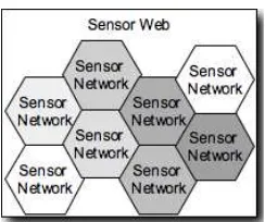
The Sensor Web is a revolutionary concept towards achieving a collaborative, coherent, consistent, and consolidated sensor data collection, fusion and distribution system. It can be viewed as a new breed of Internet for monitoring spatio-temporal phenomena appear-ing in the physical environment in real time. Any kind of sensor, from a thermometer located at a fixed position to a complex hyper-spectral sensor on board of an earth-orbiting satellite, will be made available on a global level in the near future. Sensors main at fixed locations (e.g. as part of weather stations) or move autonomously or re-motely controlled in physical space (e.g. on board of vehicles, airplanes or satellites). Once deployed, each sensor associates the phenomenon it senses with the location it cur-rently populates. This information is either stored on the sensor for later access or directly sent to aggregation systems. The retrieval and processing of sensor data, but also the management of sensor devices (i.e. tasking), will soon be carried out by means of distrib-uted software entities that interoperate via the Internet. At its stage of completions, mil-lions of sensors will be connected to a large network and produce georeferenced observa-tion data. Every single sensor provides a small mosaic stone that helps us to generate a consolidated view of the world, to get a better understanding of the past, present, and future situation of our planet as well as active processes and correlations.
Figure 5-1: Sensor Web: Aggregation of Sensor Networks
Once connected to the Sensor Web, data sets may get used multiple times in applications never intended by the original system setup. Traffic sensors that have been deployed ini-tially to avoid jams by dynamic traffic control might get used to calculate the carbon di-oxide ratios of highway sections in another application. Satellites with different sensors on board might get used in a variety of application domains that were not primarily tar-geted, simply due to interoperable interfaces that allow users to task the satellite based on distinct requirements [4].
5.2 Sensor Model
5.2.1 Overview
The OGC Sensor Model is best described using a number of different views [1]. We will use the five viewpoints defined in the ISO RM-ODP approach to shed light on the vari-ous aspects of sensors. The following discussion starts with the Technology Viewpoint, illustrating the view of a hardware manufacturer, and then reflects a “Sensor” from the Engineering, Service and Informational Viewpoint. The Enterprise Viewpoint is not con-sidered in this discussion.
Note: In this discussion, the thing observed by sensors is called “observed property” in line with the OGC Observations and Measurements model (OGC 07-022). An ob-served property identifies or describes the phenomenon for which the observation re-sult provides an estimate of its value. Based on this definition, we define a sensor to be an entity that provides information about an observed property at its output. A sensor uses a combination of physical, chemical or biological means in order to es-timate the underlying observed property.Note that, basically, these means could be applied by electronic devices or by humans. At the end of the measuring chain elec-tronic devices produce signals to be processed.
5.2.2 Technology Viewpoint
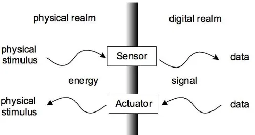
Figure 5-2: Sensor and actuator model (derived from (Ricker/Havens, 2005))
The following sections provide a more detailed discussion on sensors and distinguish between simple and complex forms of sensors and sensor systems.
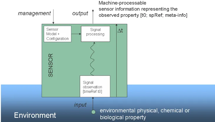
5.2.2.1 Simple Form of a Sensor
The sensor observes an environmental property which may be a biological, chemical or physical property in the environment of a sensor, at a specific point in time (t0) at a spe-cific location (spRef), i.e. within a temporal and spatial context. The location of the sen-sor might be different from the location of the observed property. This is the case for all remote-observing sensors, e.g. cameras, radar, etc. For an in-situ observing sensor, loca-tions of sensor and observed property are identical, i.e. the sensor observers a property in its direct vicinity. The simple form of a sensor provides information on single observed property. Figure 5-3 shows the model of this situation.
The observed property is usually converted to a different internal representation, usually electrical or mechanical, by the sensor. Any internal representation of the observed prop-erty is called a signal. Within the sensor any kind of signal processing may take place. Signal processing typically includes linearization, calculations based on calibration coef-ficients, conversions to different representations and any calculations to prepare the sen-sor data for output. The signal may also be transferred over longer distances.
Note: This transfer is not restricted to a signal transmission over a communication network but could also be a human carrying a chemical probe (e.g. a water probe from a river) to a laboratory.
Figure 5-3: Model of a simple form of a Sensor
Finally, the observed property is accessible at the output of the sensor in a machine pro-cessable representation. The output provides information about the time (t0) and spatial context (spRef) during observation, though those parameters are usually provided in the form of meta-information and not as part of the observation result. Due to the delay t produced by the sensor during the observation, the information at the output of the sensor cannot be accessed before t0+ t. This t can take any range from nanoseconds to several weeks or months.
Different sensors may provide different representations of the same observed property. They may differ in the units, the quality of the representation, the observation method, or the internal signal processing that was used. The estimate of the value that represents the observed property may be a single value, a range of values, a choice between worst and best value, a sequence of values or a multi-dimensional array of values representing, for example, a picture. It may contain values for each point in spatial/temporal context or it may be a statistical representation in space or time. The description of the representation as well as all other observation related information has to be provided as sensor meta-information at the sensor output to be used by an application. A sensor may internally store representations of an older temporal context (history) or spatial context.
In addition to its output, a sensor may provide an interface to perform the management of the sensor itself. For instance, this interface may be used to tag the sensor with a name, to configure the internal signal processing or to monitor the behavior of a device.
5.2.2.2 Complex form of a Sensor
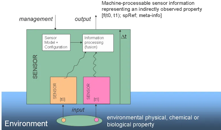
Figure 5-4: Model of a complex form of a Sensor
The information about the observed properties of the individual components of the com-plex form may be processed by any method of information processing (e.g. in fusion blocks). The output of the complex form of a sensor represents an observed property as defined by the sensor operator. This means that the linkage of the output of the complex form of a sensor to the output to the simple forms of a sensor is transparent. Still, even the complex form has to provide some information about the temporal and spatial context of its output data.
Note: Those contexts might be of different scales: A complex form of a sensor might provide forecast information for the next multi-week period in a large area, whereas the simple form provides observations at single points in time and space only.
Thus, the resulting temporal context of complex forms of sensors is a function of the temporal contexts of the individual observed properties, represented in Figure 5 5 as f(t0, t1). The same may be true for the spatial context, in Figure 5 5 represented as spRef = f(spRef1, spRef2). The function should be provided as part of the meta-information, in-cluding information about all processing steps at the output interface as well as on the management interface.
Depending on the application context, this complex form of a sensor may itself be aggre-gated into another complex form. In this case, the internal structure is a black box to the application.
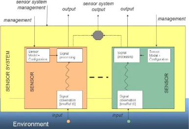
5.2.2.3 Sensor System
individual sensor separately. This is done through the management interface of the sensor system.
Figure 5-5: Model of a Sensor System
The key characteristic of a sensor system is its singular output and management inter-faces that reflect its organizational unit. The organizational unit varies in type and na-ture. Having a sensor system doesn’t necessarily mean that the individual parts of the system do not provide individual interfaces. In addition, each part of a sensor system might be unraveled into sub-systems or individual sensors with individual interfaces as well. The key characteristic of the system remains its single output- and manage-ment interface, independently of any kind of interface provided in addition. Exam-ples of sensor systems are satellites (whereas the physical structure of the satellite is a platform, not a sensor) with a number of remote-observing devices, weather stations with sensors for wind speed, temperature, and humidity, ground water observation systems used for surveillance of the environment around a chemical plant or a system of surface water observation points ordered on the surface and in the depth of a water body.
5.2.3 Engineering Viewpoint
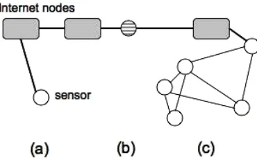
sensor network is a collection of sensors and processing nodes, in which information on properties observed by the sensors may be transferred and processed.
Internet nodes might be either connecting a single sensor (a) or a whole sensor network (c) to the communication network. Further on, a sensor system might even integrate all necessary components to act as one single network node, i.e. the sensor system is ad-dressable and accessible within the communication network (b).
Figure 5-6: Sensors connected to a Communication Network (here: Internet node)
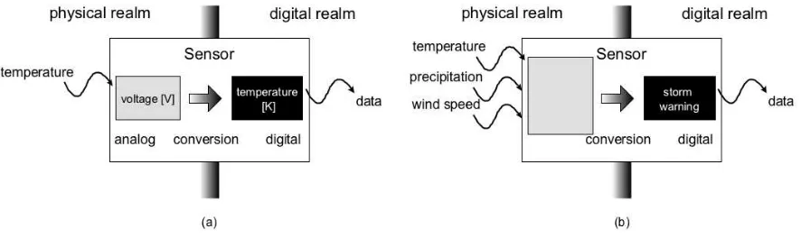
5.2.4 Computational Viewpoint1
The computational viewpoint is concerned with the functional decomposition of the sys-tem into a set of services that interact at interfaces. The transfer of this software modeling perspective into a more functional perspective of the sensor model leads to an even more complex. There are two perspectives for the computational viewpoint: an internal per-spective and an external perper-spective.
The internal perspective ignores the communication part for a moment and has a closer look at the physical device called a sensor by converting the black box sensor into a white box, (see Figure 5-7).
The sensor responds to the physical stimulus “temperature” with the generation of a cer-tain voltage observed in Volts. Afterwards, the temperature gets converted into a digital representation of degrees Kelvin.
Figure 5-7: Sensor Models, white box
The external perspective represents the view of a software developer or a designer that aims at integrating a sensor into a network of services. From this perspective, a sensor may be seen as a component in a service network with two major logical interfaces:
Information: an interface to access the data that represents the properties observed by the sensor, and
Management: an interface that enables the configuration and monitoring of the in-ternal behavior of the sensor (see the inin-ternal perspective) as well as the discovery of the sensor resources that are made accessible through the observation access in-terface.
Both interfaces have been illustrated before in Figure 5-3, Figure 5-4, and Figure 5-5. An example of a sensor data access interface is the OGC Sensor Observation Service as de-scribed in section 7.5. An example of a management interface to a sensor is the OGC Sensor Planning Service as described in section 7.7.
From the service viewpoint, it often makes sense to consider a simulation model as a sen-sor, because a model can provide data for times in the past or future analogous to a sensor device. This view is, for example, found in [3]. The main reason for this very broad usage of the term “sensor” results from research and standardization efforts within the domain of service-oriented architectures. Here, web services providing access to sensor data are often called 'Sensor Services'. As long as sufficient meta-information comes along with the data (e.g. how the data were produced, quality etc.), it does not make any difference for the client if physical devices or simulation models produced the data. This approach has the advantage that generic sensor applications may be built that retrieve their data from physical sensors (usually past observation results) in the same way as from simula-tion models (i.e. calculated future observasimula-tion results in case of predicsimula-tion models).
5.2.5 Information Viewpoint
We speak of a sensor as a source that produces a value within a well-defined value space of an observed property, which may represent a physical, biological or chemical envi-ronmental phenomenon. Sensors and sensor systems as well as simulation models fulfill this definition. If the semantics did not differentiate between produced data based on a physical stimulus or any other data, the limit between model and sensor disappears. In the information viewpoint, we abstract from the source of observation data and con-centrate on the data that are provided in the form of observation results. Those observa-tion results have to follow the sensor data informaobserva-tion model, i.e. the results have to re-flect all aspects of the underlying viewpoints. In addition to the observation result, infor-mation about the observation procedure, spatial-temporal context, and organizational characteristics have to be provided. Such information is considered to be
meta-information for the purpose of interpretation and further processing of the observation results.
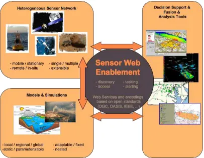
6 Sensor Web Enablement
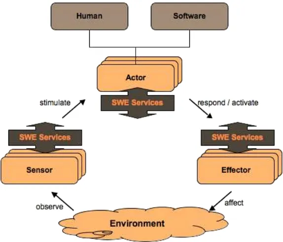
Figure 6-1: SWE Framework
Figure 6-2: SWE Operation Cycle
Humans might be part of this cycle, which otherwise operates fully automatically. SWE services and encodings support the observation of the environment, decision-making, and influencing the environment.
6.1 Motivation
It has long been recognized that the current state of sensor networks is that they are de-veloped around different communities of sensor types and user types, with each commu-nity typically relying on its own stovepipe system for discovery, accessing observations, receiving alerts, and tasking sensor systems and models. Even within fairly coherent communities, each type of sensor tends to be accompanied by its on metadata semantics, its own data formats, and its own software.
Within such stovepipe systems, the ability to discover and utilize a new sensor asset is typically hindered by incompatible encodings and services. Additionally, readily availa-ble information regarding the sensor system, the observation encodings, processing, and supporting services is typically lacking, scattered, or incomplete. Within these systems, adding support for a new sensor asset to an existing decision support tool or processing operation takes at best several days, and at worst many months or years, accompanied by high expense.
As described in the Introduction, the Sensor Web Enablement (SWE) framework has been designed to enable solutions that meet the following desires:
particularly important, for example, during rescue or mitigation operations fol-lowing an unexpected disaster or attack
Determination of a sensor’s capabilities and an observation’s reliability – we wish to provide the ability to readily assess the capabilities of a sensor or simula-tion system, as well as provide sufficient lineage of an observasimula-tion to determine its reliability for decision support
Access to parameters and processes that allow on-demand processing of ob-servations – we wish to provide the means to sufficiently be able to support on-demand geolocation and processing of sensor observations by generic software, without the need for a priori knowledge of the sensor system
Retrieval of real-time or time-series observations in standard encodings – we wish to be able to access and immediately utilize observations from newly dis-covered sensors within decision support tools, models, and simulations without needing to develop sensor-specific readers
Tasking of sensors and simulators to acquire observations of interest – we wish to be able to task a sensor or simulation system, and to provide my collection requirements, using a common interface; this interface needs to be able to support tasking as simple as controlling a web cam, as well as something as sophisticated as a military surveillance operation
Subscription to and publishing of alerts based on sensor or simulation obser-vations - we wish to provide a means by which a sensor system or simulation can publish possible alerts to be issued by sensors or sensor services based upon cer-tain criteria, and allow one to subscribe to and receive these alerts when criteria are met; such criteria could be a simple as a measured value exceeding a certain threshold or as complex as pattern recognition within a single or multiple observa-tions
6.2 Approach
Within the SWE initiative, the enablement of such sensor webs is being pursued through the establishment of three encodings for describing sensors and sensor observations, and through four standard interface definitions for web services:
Sensor Model Language (SensorML) – standard models and XML Schema for de-scribing sensors systems and processes; provides information needed for discov-ery of sensors, location of sensor observations, processing of low-level sensor ob-servations, and listing taskable properties
Observations and Measurements Schema (O&M) – standard models and XML Schema for encoding observations and measurements from a sensor, both ar-chived and real-time
Sensor Observations Service (SOS) – standard web service interface for requesting, filtering, and retrieving observations and sensor system information
Sensor Planning Service (SPS) – standard web service interface for requesting user-driven acquisitions and observations, to (re-)calibrate a sensor or to task a sensor network
Sensor Alert Service (SAS) – standard web service interface for publishing and sub-scribing to alerts from sensors
Web Notification Services (WNS) – standard web service interface for asynchro-nous delivery of messages or alerts from any other web service
6.3 SWE Services and Encodings Interaction
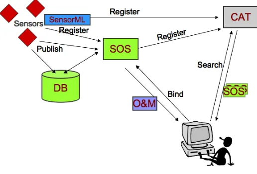
The SWE Services and Encodings interactions are illustrated in the following figures. In the upper right corner, Figure 6-3 shows sensors that are registered at a SOS and publish observation results to the services itself (then we speak of a Transactional-SOS) or into a database which will be accessed by the SOS service instance. To be discoverable, sen-sors, using SensorML, and SOS register at a catalog service. The user in the lower left corner requires observation data and sends therefore a search request to the catalog. The catalog responses with a list of SOS service instances that fulfill the requirements. Even-tually, the user binds the SOS and retrieves the observation data, encoded in O&M.
Figure 6-3: SWE Services and Encodings Interactions, part 1
is opaque for the user. If we imagine a satellite that has to reorient its infrared cameras and has to reach its target position in space, the tasking might take a while. Once observ-ing the requested scene, the sensor dumps its data into a database that is linked to a SOS. The SPS informs the user about data availability using a Web Notification Service. This has the advantage that the SPS can respond to the tasking request right away and has a mechanism to reach the user at a later stage, e.g. if the data is available or if the tasking is delayed or cancelled. The notification message contains all necessary information to ac-cess the data from a SOS.
Figure 6-4: SWE Services and Encodings interactions, part 2
Often, we are faced with the situation that a client is not interested in all observation re-sults of a sensor, but wants to get notified immediately if a specific situation is observed. Figure 6-5 illustrates this scenario.
Once again, the client receives information about appropriate SAS from a catalog and subscribes to the SAS. Sensors publish observation results continuously to the SAS. The SAS handles all the filtering and alerts the client if the subscription condition is matched. The SAS either sends the alert directly to the client, or makes use of the WNS in order to deliver the alert message.
6.4 Example Scenarios
As an example of a use-case scenario in which a SWE-enabled sensor web capabilities might support, consider the need for remedial action following a massive explosion and the subsequent widespread burning of toxic materials. A small sampling of the interac-tions with web-enabled sensor components could include:
1. an emergency management team (e.g. FEMA) uses sensor registry to discover that NASA has an airborne sensor capable of providing thermal imaging through smoke and clouds (note: there was an actual need to discover such a sensor fol-lowing the WTC attacks, but the capabilities of and access to the sensor were not discovered until many days after the real need passed) … team places a request for acquisition through SPS and within the hour receives notification through WNS that task is approved and scheduled
2. wind profilers in surrounding area are discovered through sensor registries… measurements obtained (through SOS), geolocated (using SensorML), and ap-plied to simulations of aerosol plume transport … results predict the downwind dispersion location of toxic cloud over the next 6-12 hours
3. biochemical “sniffers” are discovered that are available through secure connec-tions as part of the homeland security initiative .... sensor capabilities are queried and it is determined (using SensorML) that these sensors are capable of detecting the chemical species in question and have high enough sensitivities to detect probable concentrations … team subscribes to alerts when concentrations above a specific value are detected (notice to be sent by email/SMS (Short Message Ser-vice) to FEMA personnel and by URL to plume simulation service for automatic updating and refinement of its model runs)
4. through a sensor registry, mobile sensors for monitoring toxic aerosols are dis-covered to be available through a regional commercial emergency response team … monitor deployment requested and authorized through SPS … FEMA sub-scribes to alerts from these sensors when certain concentration thresholds are ex-ceeded … alerts sent automatically (by SAS) from field sensors via wireless net-work along with locations and measurements … containment and medical teams sent to appropriate areas to tend to the local situation
6. sensors onboard emergence response vehicles monitor not only the location of these vehicles at all times, but some also provide mobile measurement of airborne toxin concentrations; real-time video streams (TML) from sensors onboard UAVs and other airborne platforms are provided through SOS services along with Sen-sorML processes for geolocation of video, allowing real-time hazard assessment and rescue monitoring
7. all of these data and services are available to one or more SWE-enabled decision support tools that are capable of processing and fusing this information without a priori knowledge of any of the sensor systems involved
This is, of course, only a single possible scenario of the application of SWE supported assets. Additional scenarios have been created for autonomous sensor webs where sensor systems are capable of subscribing to alerts from other sensors and modifying their own sensing behavior based on these alerts.
7 Implementation components
The SWE components serve different purposes with one aspect being common to all components: The usage of fundamental types for data and metadata modeling and encod-ing. Those aspects common to all SWE standards are defined in a separate namespace called SWE Common. We will briefly describe SWE Common before an overview of the SWE components listed in Section 6.2 is given. Detailed information is provided within separate documents, one for each encoding or service.
7.1 SWE Common
There are several common core definitions used throughout the SWE framework that have been pulled from other SWE specifications, such as O&M and SensorML, and have been placed within the SWE Common namespace. These are currently not defined within a separate document, but rather are defined within SensorML (mostly) or O&M specifi-cation documents. Future releases will separate SWE Common definitions into a separate document. Discussion in this direction just have started (end of 2007).
SWE Common knows a number of fundamental types that derive from the Abstract-DataComponent (which is derived from gml:AbstractGMLType, i.e. it implements ab-stract-types of the Geography Markup Language, GML). The scalar data component types use Range elements to define minimum and maximum.
Count represents a ‘countable’ property that can be quantified using an integer value. A CountRange provides minimum and maximum values as an integer pair in that order.
Quantity represents a numerical that can be quantified using a decimal value. A
Boolean is a simple data component that represents a property that can be true or false
Text is a simple data component that represents a property that takes a string as its value
Category represents textual data that is a member of some larger grouping of val-ues
Time is supported and treated as a special type of numerical scalar. A TimeRange
provides minimum and maximum values as a time value pair in that order. These basic data types can be grouped within any of several aggregate objects. Those aggregate objects are described in detail in the SensorML specification. SWE Common provides a number of different encoding options also.
7.2 Sensor Model Language (SensorML)
The measurement of phenomena that results in an observation consists of a series of pro-cesses, beginning with the processes of sampling and detecting and followed perhaps by processes of data manipulation. The division between measurement and
“post-processing” has become blurred with the introduction of more complex and intelligent sensors, as well as the application of more on-board processing of observations. The typi-cal Global Positioning System (GPS) sensor is a prime example of a device that consists of basic detectors complemented by a series of complex processes that result in the ob-servations of position, heading, and velocity.
SensorML defines models and XML Schema for describing any process, including meas-urement by a sensor system, as well as post-measmeas-urement processing. SensorML supports a variety of needs within the sensor community, including:
Discovery of sensor, sensor systems, and processes - SensorML is a means by which sensor systems or processes can make themselves known and discoverable. SensorML provides a rich collection of metadata that can be mined and used for dis-covery of sensor systems and observation processes.
On-demand processing of Observations - Process chains for geolocation or higher-level processing of observations can be described in SensorML, discovered and dis-tributed over the web, and executed on-demand without a priori knowledge of the sen-sor or processen-sor characteristics.
Observation Services (SOS), Sensor Planning Services (SPS), and Sensor Alert Ser-vices (SAS). SensorML defines and builds on common data definitions that are used throughout the OGC Sensor Web Enablement (SWE) framework.
Plug-N-Play, auto-configuring, and autonomous sensor networks - SensorML en-ables the development of plug-n-play sensors, simulations, and processes, which seamlessly be added to Decision Support systems. The self-describing characteristic of SensorML-enabled sensors and processes also supports the development of auto-configuring sensor networks, as well as the development of autonomous sensor net-works in which sensors can publish alerts and tasks to which other sensors can sub-scribe and react.
Archiving of Sensor Parameters - Finally, SensorML provides a mechanism for ar-chiving fundamental parameters and assumptions regarding sensors and processes, so that observations from these systems can still be reprocessed and improved long after the origin mission has ended. This is proving to be critical for long-range applications such as global change monitoring and modeling.
Figure 2. SensorML process types
Figure 7-1. ProcessChain aggregates process models, other process chains, or data sources
System is a physical equivalent of a ProcessChain. It allows one to relate one or more processes to the “real world” by allowing one to specify relative locations and data inter-faces. A System may include several physical and non-physical processes. In addition to the individual process of a process chain and its relationship to each other in terms of out-input behavior, a System defines the position of each component, i.e. it allows describing one physical asset in relation to another one.
A public forum for SensorML is actively available at
http://mail.opengeospatial.org/mailman/listinfo/sensorml.
7.3 Observations and Measurements (O&M) [OGC 07-022 & OGC 07-002r2]
The general application of a sensor is to observe one or many properties in its environ-ment. Each property belongs to a specific feature that represents an identifiable object. Applying the more general sensor model as described in clause 5.2, sensors observe properties of features and produce values for those properties. The observation itself is modeled as feature as well.
To reflect the general difference between the observation itself, i.e. the act of producing a value for a property of a feature, and the sampled feature itself, Observations and Meas-urements consists of two parts: Part one, Observation schema (OGC 07-022), describes a conceptual model and encoding for observations and measurements. This is formalized as an Application Schema, but is applicable across a wide variety of application domains. Part two, Sampling Features (OGC07-002r2), describes a conceptual model and encoding for the feature that has been observed. According to O&M, every observed property be-longs to a feature of interest. Though often treated as identical and mostly of little interest to the consumer of the observation data, there is a conceptual difference between the
Sampled Feature and the Feature of Interest of an observation. The difference is de-scribed best using some examples:
In remote sensing campaigns, the sampled feature is a scene or a swath, whereas the feature of interest often defined as a parcel, a region, or any other form of ge-ographically bounded area
In-situ observation campaigns may obtain the geology of a region at outcrops (sampled features), whereas the feature of interest is the region itself
Meteorological parameters might get sampled at a station, whereas the feature of interest is - strictly spoken - the world in the vicinity of that station
As said before, those differences are often of interest to members of the sampling cam-paign only. From a data consumer’s point of view, who is not analyzing the data for po-tential errors in the sampling itself, sampling feature and feature may be identical. The term Measurements in Observation & Measurements reflects the fact that most sen-sors produce estimates for physical quantities, i.e. for measures. Thus, a measurement is a specialized observation. This is somewhat is contrast to the conventional measurement theory, but inline with discussions in recent publications.
Figure 7-3: Binding of observation results to properties of the sampled feature
An observation uses a procedure to determine the value of the result, which may involve a sensor or observer, analytical procedure, simulation or other numerical process. This procedure would typically be described as a process within SensorML. The observation pattern and feature is primarily useful for capturing metadata associated with the estima-tion of feature properties, which is important particularly when error in this estimate is of interest.
Figure 4. Simplified structure of the O&M Observation describing the fea-tureOfInterest, the applied process, the observedProperty (which is a charac-teristic of the featureOfInterest), the result and the quality of the result value, the samplingTime (time the sample was taken) and resultTime (time the result was produced, which might be the same as samplingTime), additional metada-ta, and parameters describing the observation event that are not tightly bound to the process or featureOfInterest.
communities may define their own result models and use them within their community. From a universal point of view, this flexibility may prevent non-members of those com-munities to make any sense out of the result data. It is still an area of current research to define styles that adequately and efficiently support both simple and complex results, as well as perhaps legacy formats and out-of-band data. These observation models typical differ only in the encoding of the resultDefinition and result properties. All other proper-ties of the Observation model remain common for all derived observation types. There-fore the O&M specification allows for extension of the Observation object to support various styles of providing observation result values and defines a number of Observation specializations that cover the most frequently used observation-types.
Experiences have shown that users usually use those specializations and may amend them with community-specific extensions, rather than defining result models directly derived from Observation. This strategy simplifies the identification of certain key elements of the result set and allows some processing of the result data, e.g. for visualization purpos-es, without understanding the full result model. Parsers simply skip the extensions. O&M defines the following specializations of the generic observation (in a separate namespace named “omx” to avoid clashing of XML Schema imports):
For single-value properties, the observation feature is modeled as
CountObservation, if the result is an integer representing the count of the ob-served property
CategoryObservation, if the result is a textual value from a controlled vocabulary
TruthObservation, if the result is a boolean value representing the truth value (usually existence) of the observed property
GeometryObservation, if the result is a geometry
TemporalObservation, if the result is a temporal object
ComplexObservation, if the result is a record representing a multi-component phenomenon
Measurement, if the result is a Measure, i.e. the result is a value described using a numeric amount with a scale or using a scalar reference system
If the values of the property vary over time and/or space, then the observation-type is modeled as discrete coverages of type:
PointCoverageObservation, if the result is a point coverage which samples prop-erties at points in the feature of interest,
TimeSeriesObservation, if the result is a time-instant coverage which samples a property of the feature of interest at different times
ElementCoverageObservation, if the result is a coverage whose domain elements contain references to objects encoded elsewhere, which provide the sampling ge-ometry of the feature of interest
Through the O&M specification, the SWE framework provides a standard XML-based package for returning observation results. Using a standard package in which to down-load observations from an SOS alleviates the need to support a wide range of sensor-specific and community-sensor-specific data formats. To achieve an even higher level of in-teroperability, SWE Common shall be used to fill in the result slot of an observation.
7.4 Transducer Model Language (TML) [OGC 06-010r6]
Transducer Markup Language (TML) is a method and message format for describing information about transducers and transducer systems and capturing, exchanging, and archiving live, historical and future data received and produced by them. A transducer is a superset of sensors and actuators. TML provides a mechanism to efficiently and effec-tively capture, transport and archive transducer data, in a common form, regardless of the original source. Having a common data language for transducers enables a TML process and control system to exchange command (control data) and status (sensor data) infor-mation with a transducer system incorporating TML technology. TML utilizes XML for the capture and exchange of data.
TML was designed with the express goal of facilitating the development of a “Common” Transducer Processing/Control machine while also facilitating interoperable machine-to-machine communications. For the purposes of data fusion and post analysis, it is para-mount to preserve raw transducer data in as close a manner to the original form as possi-ble. Although data would be ideally preserved in its raw format, it is impossible in some cases to do so. TML provides facilities to capture data at any stage, from raw production, to partially processed, to final data forms. Greater benefits of TML are realized the clos-er to the source raw data one gets.
Transducer Markup Language (TML) defines:
a set of models describing the hardware response characteristics of a transducer. an efficient method for transporting sensor data and preparing it for fusion through spatial and temporal associations
Sensor data is often an artifact of the sensor’s internal processing rather than a true record of phenomena state. The effects of this processing on sensed phenomena are hardware-based and can be characterized as functions.
noise figure, spatial and temporal geometries, frequency response, steady-state response and impulse response.
Traditional XML wraps each data element in a semantically meaningful tag. The rich semantic capability of XML is in general better suited to data exchange rather than live delivery where variable bandwidth is a factor. TML addresses the live scenario. The TML cluster is a terse XML envelope designed for efficient transport of live multiplex sensor data. It also provides a mechanism for temporal correlation to other transducer data.
In November 2005, the TML specification document OGC 05-085 was approved as a Public Discussion Paper. In February 2006, TML document OGC 06-010 was submitted as a Pending Document to the Huntsville Technical Committee (March 2006) to begin the RFC process as an OGC Technical Specification. Eventually, version OGC 06-010r6 was released as OGC Standard. Further information on TML can be found at
http://www.transducerml.org.
7.5 Sensor Observation Service (SOS) [OGC 06-009]
The goal of SOS is to provide access to observations from sensors and sensor systems in a standard way that is consistent for all sensor systems including remote, in-situ, fixed and mobile sensors. This is a challenging task because the users of sensor data have his-torically been divided into those who primarily deal with in-situ sensors and those who primarily deal with remote sensors. The terminology, perspective, and expectations of these two broad groups are different. SOS leverages the Observation and Measurements (O&M) specification for modeling sensor observations and the SensorML specification for modeling sensors and sensor systems.
An SOS organizes collections of related sensor system observations into Observation Offerings. The concept of an Observation Offering is equivalent to that of a sensor con-stellation discussed earlier in this document. An Observation Offering is also analogous to a “layer” in Web Map Service because each offering is intended to be a
non-overlapping group of related observations. Each Observation Offering is constrained by a number of parameters including the following:
Specific sensor systems that report the observations,
Time period(s) for which observations may be requested (supports historical da-ta),
Phenomena that are being sensed,
Geographical region that contains the sensors, and
The approach that has been taken in the development of SOS, and the SWE specifications on which it depends, is to carefully model sensors, sensor systems, and observations in such a way that the model covers all varieties of sensors and supports the requirements of all users of sensor data. This is in contrast to the approach that was taken with the Web Feature Service (WFS). WFS provides a generic definition of a geographic feature that is flexible enough to encompass any real-world entity. The WFS uses GML application schemas to define the specific properties of each type of feature. With this approach, in-teroperability requires organizations to agree on domain-specific GML application sche-mas. Clients that access a WFS in a particular domain must have a-priori knowledge of the application schemas used in that domain. The SOS approach defines a common mod-el for all sensors, sensor systems and their observations. This modmod-el is not domain-specific and can be used without a-priori knowledge of domain-domain-specific application schemas.
In November 2005, the SOS specification document OGC 05-088r1 was approved as a Public Discussion Paper. In February 2006, SOS document OGC 06-009 was submitted as a Pending Document to the Huntsville Technical Committee (March 2006) to begin the RFC process. Eventually, OGC document 06-009r6 was approved as an OGC Stand-ard.
7.6 Sensor Alert Service (SAS) [OGC 06-028r5]
The Sensor Alert Service (SAS) can be compared with an event stream processor in com-bination with an event notification system. An SAS processes incoming sensor data con-tinuously. Pattern-matching algorithms identify satisfied alert conditions and start the alert distribution process.
An SAS might therefore provide a wide variety of alerts related to sensors and sensor observations including, as examples, measured values above a threshold, detected motion or the presence of a recognizable feature, or perhaps sensor status (e.g. low battery, shut-down or startup). SAS is a transactional service in two counts: First sensors can dynami-cally connect to the service and publish metadata and observation data (using SensorML and O&M). Sensors don’t have any knowledge about current subscriptions, as SAS doesn’t provide such information. Second, event consumers may define their own event conditions. For every new event type definition, the SAS is opening a new distribution channel and incorporates the alert type in its capabilities documentation, i.e. every new alert type, defined by an alert consumer, is available to other users as well.