Seamless Synthetic Aperture Radar Archive for Interferometry Analysis
S. Baker a, C. Baru d, G. Bryson b, B. Buechler b *, C. Crosby a, E. Fielding c, C. Meertens a, J. Nicoll b, C. Youn d a
UNAVCO, Boulder, CO – (baker, crosby, meertens)@unavco.org b
Alaska Satellite Facility, Geophysical Institute, University of Alaska Fairbanks, Fairbanks, AK – (gbryson, btbuechler, jbnicoll)@alaska.edu
c
Jet Propulsion Laboratory, California Institute of Technology, Pasadena, CA - [email protected] d
San Diego Supercomputer Center, University of California San Diego, La Jolla, CA – (baru, cyoun)@sdsc.edu
KEY WORDS: Radar, SAR, DEM, Data Mining, Processing, Archiving, Change Detection
ABSTRACT:
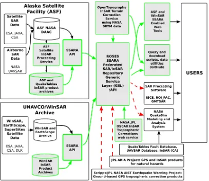
The NASA Advancing Collaborative Connections for Earth System Science (ACCESS) seamless synthetic aperture radar (SAR) archive (SSARA) project is a collaboration betweenUNAVCO, the Alaska Satellite Facility (ASF), the Jet Propulsion Laboratory (JPL), and OpenTopography at the San Diego Supercomputer Center (SDSC) to design and implement a seamless distributed access system for SAR data and derived interferometric SAR (InSAR) data products. A unified application programming interface (API) has been created to search the SAR archives at ASF and UNAVCO, 30 and 90-m SRTM DEM data available through OpenTopography, and tropospheric data from the NASA OSCAR project at JPL. The federated query service provides users a single access point to search for SAR granules, InSAR pairs, and corresponding DEM and tropospheric data products from the four archives, as well as the ability to search and download pre-processed InSAR products from ASF and UNAVCO.
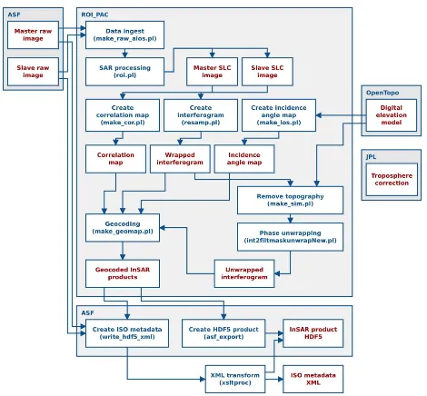
Figure 1. Diagram of SSARA workflow. Grey highlighted boxes show component development as part of the project, green outlines represent tasks already implemented and red outlines represent future implementation.
1. INTRODUCTION
1.1 Overview
Differential interferometric synthetic aperture radar (InSAR) is used to measure displacements on Earth’s surface to a precision of a few centimeters or less. InSAR data are largely used to study deformation caused by earthquakes, volcanic eruptions, glacier movements, landslides, and subsidence. They may also be used to examine the distribution of water vapor in the atmosphere, among other applications.
An interferogram is formed from two or more SAR granules acquired at different times that cover the same area of ground and have the same acquisition geometry. These granules are referred to as a master image and slave image(s). Interferometry from a single pair of SAR images contains direct topographic and atmospheric effects that must be removed in order to create a quality InSAR product.
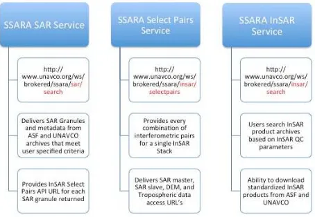
The SSARA application programming interface (API) enables users to search and download InSAR master and slave granules from the SAR archives at ASF and UNAVCO (http://www.unavco.org/ws/brokered/ssara/sar/search); corresponding DEMs from Open Topography and tropospheric
data from JPL
(http://www.unavco.org/ws/brokered/ssara/insar/selectpairs); and sample standardized InSAR data products from ASF and UNAVCO
(http://www.unavco.org/ws/brokered/ssara/insar/search).
Figure 2. SSARA API Services and corresponding uniform resource locators (URL).
1.2 Objectives
The SSARA collaboration set the following objectives:
• Develop and implement a single access point for metadata query and data product download capabilities from distributed airborne and spaceborne SAR archives at ASF and UNAVCO
• Define and implement new quality control (QC) parameters and products to enhance the usability of data from existing NASA-funded data collections
• Develop standard formats for image products such as interferograms, tropospheric measurements, and terrain corrections
• Implement a web services enabled terrain correction service using NASA SRTM data
• Enhance ASF SAR interferometric processing service to access distributed SSARA data collections, utilize terrain correction service, and generate enhanced QC products
• Establish processed InSAR data products and QC product archives at ASF and UNAVCO
2. DATA ARCHIVES
2.1 SAR Data Archive at ASF
The ASF of the Geophysical Institute (GI) at the University of Alaska Fairbanks, downlinks, archives, and distributes satellite-based data to scientific users around the world. ASF's NASA-sponsored Distributed Active Archive Center (DAAC) specializes in SAR data collection, processing, archiving, and distribution. These data are processed on-demand through URSA (https://ursa.asfdaac.alaska.edu/) or can be downloaded as a standardized Level 0, Level 1 Complex, or Level 1 Detected products from the ASF Data Pool via Vertex (https://vertex.daac.asf.alaska.edu/) or the ASF API (http://api.daac.asf.alaska.edu/services/search/param).
The ASF Data Pool contains over 500 TB of online readily-downloadable data. Those datasets useful for interferometry can be searched publicly, including browse products for selected datasets, and Keyhole Markup Language (KML) files of locations for all datasets, but require user authentication to access the data themselves. This authorization is through on-line initiated proposal submission services, coordinated by ASF, with access granted through NASA.
2.2 SAR Data Archive at UNAVCO
UNAVCO is a non-profit university-governed consortium that operates the National Earth Science Geodesy Advancing Geosciences and EarthScope (GAGE) Facility.
UNAVCO is home to the Western North America InSAR Consortium (WInSAR) archive (http://winsar.unavco.org) that was originally constructed to handle a limited ERS-1 and ERS-2 satellite data collection. In recent years, the WInSAR archive has expanded to include Envisat data brining the total archive holdings to approximately 32,000 SAR scenes from ESA. More recently, the archive has been expanded to manage TerraSAR-X data for WInSAR PIs with approved DLR proposals to facilitate easier access and data sharing with individual co-investors (Co-Is) on the projects. There are over 1200 scenes from 15 PI proposals. UNAVCO also operates the EarthScope SAR archive, which holds over 105,000 frames of ERS-1, ERS-2, Envisat, and Radarsat-1 data. UNAVCO and WInSAR worked with the European Space Agency (ESA) to promote and develop the Group of Earth Observation (GEO) Geohazard Supersites and Natural Laboratories (GSNL) (http://supersites.earthobservations.org) data sharing concept and to prototype infrastructure for SAR data. UNAVCO ordered data from the ESA and access to the data are provided through the Virtual Archive 4 after self-registration. (http://eo-virtual-archive4.esa.int/). UNAVCO also archives COSMO-SkyMed and Radarsat-2 data on behalf of the GSNL for select locations.
users must be affiliated with a full or adjunct I consortium member institution and sign the data use agreements from the space agencies. For the TerraSAR-X and GSNL data holdings at UNAVCO, users must contact the PI on the proposal and be added as a Co-I in order to gain access to the data. WInSAR also offers a mechanism for Consortium members to request ordering of archived scenes over North America for ERS and Envisat data that are not yet in WInSAR holdings.
2.3 DEM Data Archive at OpenTopography
The NSF-funded OpenTopography facility (OT, http://www.opentopography.org) provides community access to high-resolution (e.g., lidar) and other (e.g., SRTM) Earth science-oriented, topography data, and related tools and resources (Crosby et al., 2011). OT has developed a cyberinfrastructure platform built on a service oriented architecture (SOA) to enable efficient online access to these datasets along with web based processing tools to generate derived products including digital elevation models (DEMs) (Krishnan et al., 2011). All data access functions and processing algorithms are packaged as web services deployed across multiple OpenTopography commodity clusters,
leveraging the open source OPAL toolkit
(http://sourceforge.net/projects/opaltoolkit/). OPAL is an open-source toolkit developed by the National Biomedical Computation Resource (NBCR) and the San Diego Supercomputer Center (SDSC) that enables users to wrap scientific applications running on cluster and Grid resources as Web services. Since the service-oriented architecture of OT supports a distributed environment and service interoperability with its loose coupling and published APIs using standards based communication protocols, it is beneficial for other communities to be easily integrated with the topography datasets’ processing capabilities for the derivation of higher-level analysis products.
Current OpenTopography LiDAR point cloud data holdings alone exceed 18 terabytes (in compressed binary format) covering approximately 170,476 km2 of important geologic features such as the San Andreas Fault, Yellowstone, Tetons, Yosemite National Parks, etc. Global datasets such as the SRTM 30 and 90 meter datasets are also available. Typically, users interact with the portal interface to perform sub-selections of the datasets and run processing algorithms on their area of interest to produce derivative products like DEMs, hillshade, visualizations, and morphometric products such as slope (Youn et al., 2014).
2.4 Tropospheric Data Archive at JPL
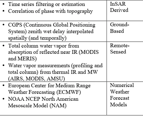
SSARA builds upon the web services provided by the JPL Online Services for Correcting Atmosphere in Radar (OSCAR) project (Allmen et al., 2011). OSCAR locates, retrieves, and merges multiple data sets to derive an optimal, best estimate of tropospheric delay (Table 3). The service produces maps of the precipitable water vapor for a single date. However, in order to deliver proper results, data must be acquired during the daytime under cloud-free conditions. When combined with SAR imagery OSCAR provides estimates of radar propagation delay for each SAR scene
One of the largest sources of errors in InSAR measurements are variations in radar wave propagation through the atmosphere. In the troposphere, the propagation of radio waves is affected by the total mass of atmosphere along the path (often called the
“dry” delay) and the integrated amount of water vapor along the path (usually called the “wet” delay). The total mass of the atmosphere is easily calculated from the surface pressure. The atmospheric water vapor content can be measured by satellite instruments, such as the MODIS instruments on Terra and Aqua (Li et al., 2005) or estimated from weather models. GPS ground station data processing for precise locations includes estimation of the tropospheric path delay due to both the dry and wet components, which is exactly the same delay that affects InSAR measurements (Li et al., 2006). The Scripps/JPL GPS AIST project is routinely producing these tropospheric delay products for the continuous GPS stations that they process.
• Time series filtering or estimation • Correlation of phase with topography
InSAR Derived
• CGPS (Continuous Global Positioning System) zenith wet delay interpolated spatially (and temporally)
Ground-Based
• Total column water vapor from absorption of reflected near IR (MODIS and MERIS)
• Water vapor measurements (profiling and total column) from thermal IR and MW (AIRS, MODIS, AMSU)
Remote-Sensed
• European Center for Medium Range Weather Forecasting (ECMWF) • NOAA NCEP North American
Mesoscale Model (NAM)
Numerical Weather Forecast Models
Table 3. Datasets utilized by OSCAR to derive tropospheric water vapor corrections for InSAR.
3. INSAR ARCHIVE quality InSAR product.
Currently, the bulk of InSAR processing is done by individual scientists, often using the Repeat Orbit Interferometry Package (ROI_PAC), the InSAR Scientific Computing Environment (ISCE), or the Generic Mapping Tool SAR software (GMTSAR). ROI_PAC and ISCE are NASA-funded software packages developed by JPL/Caltech and distributed at no charge for non-commercial use. UNAVCO distributes the ISCE
software for WInSAR member institutions
on an image pair.
The SSARA project reduces these obstacles by providing users with the means to search and download SAR pairs, and corresponding DEM and tropospheric data using a single API (http://www.unavco.org/ws/brokered/ssara/insar/selectpairs). In addition, SSARA created an archive of approximately 700 downloadable sample InSAR products at the ASF and an archive of Principal Investigator contributed interferograms at UNAVCO. Products from the InSAR archives are available to users from the unified SSARA API access point (http://www.unavco.org/ws/brokered/ssara/insar/search).
Figure 4. HDF5 Data and Metadata Structure as displayed in HDFView.
3.1 Product Contents and Format
Prototyped standardized InSAR products are distributed in HDF5 format and structured to follow the NetCDF Climate and Forecast (CF) Metadata Convention. The sample HDF5 InSAR products contains a data section with imagery and a metadata section with detailed information that corresponds to each data set (Figure 4).
There are five sets of data included with the sample InSAR products: correlation map, wrapped interferogram, unwrapped interferogram, digital elevation model, incidence angle map, and corresponding metadata. The correlation maps vary in value range between 0, complete loss of correlation, to 1, perfect correlation between master and slave image (Figure 5). The wrapped interferogram contains phase information with fringes that limit the values within a range of -π and +π. Phase unwrapping produces continuous phase values that can be directly linked to terrain height with the baseline information. A DEM is used to remove topographic effects from the InSAR
product and an incidence angle map derived from the DEM is added for advanced analysis purposes. The metadata section contains the metadata for the correlation map, wrapped and unwrapped interferogram, DEM, and incidence angle map, as well as metadata for the original SAR master and slave data used to generate the sample InSAR product.
Figure 5. Correlation Map.
In addition to the HDF5 sample InSAR product, ASF provides a browse image of the unwrapped interferogram in JPEG format and four KML overlay files in compressed KMZ format: amplitude, wrapped and unwrapped interferogram, and correlation.
Figure 6. Browse of unwrapped interferogram.
Figure 7. KML overlay of terrain corrected SAR amplitude image.
displayed in Table 8. The sample InSAR products are currently distributed with XML and ISO 19115 compliant metadata (Figure 9)
HDF5 Product: ALPSR_06713_08055_0770.h5 Browse Image: ALPSR_06713_08055_0770.jpg XML Metadata: ALPSR_06713_08055_0770.xml
KML Overlay: ALPSR_06713_08055_0770.amp.kmz
ALPSR_06713_08055_0770.cor.kmz ALPSR_06713_08055_0770.int.kmz ALPSR_06713_08055_0770.unw.kmz
Log File: ALPSR_06713_08055_0770.log.txt
Table 8. Example files included in the sample standardized InSAR products.
Figure 9. Example of XML metadata file used to generate ISO compliant metadata.
3.2 Calculating Baselines
In principle, SAR data from all satellites in the ASF and UNAVCO archives should be suitable for InSAR, as long as the image pair adheres to some basic rules: the data needs to be acquired by the same satellite, in the same beam mode, and with the same look direction. There are a few exceptions to this rule. The tandem mode of the ERS-1 and ERS-2 satellites provides data very suitable for InSAR applications because both satellites meet the criteria above and have a favorable
temporal baseline (data acquired one day apart). All the data in the ASF archive, except RAMP data, are right looking. This means that RAMP data cannot be combined with any other Radarsat-1 data, even if those had been acquired with the same beam mode. ScanSAR data, available for R1 or ALOS PALSAR, are another special case, as they are formed by combining several beam modes in one data set.
An InSAR stack is composed of all granules that cover the same geographic region, are from the same platform, and were acquired with the same beam mode. Theoretically, any two granules in an InSAR stack may be used to create an interferogram, as long as the baseline is not beyond a certain critical length.
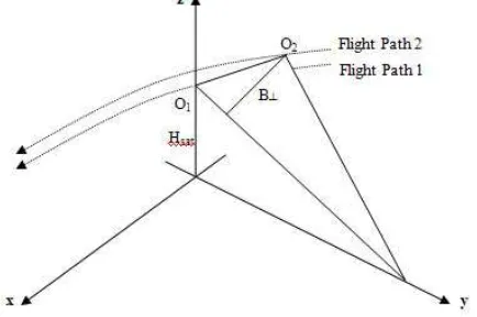
Figure 10. Baseline length is the temporal and spatial distance between two satellite observations
Perpendicular Baseline (�!) is the spatial distance between the first and second observations measured perpendicular to the look direction. It gives an indication of the sensitivity to topographic height, the amount of decorrelation due to phase gradients, and the effectiveness of the phase unwrapping. The longer �!, the weaker the coherency and the lower the sensitivity to height changes (Hanssen, R.). Temporal Baseline is the time difference between the first and second acquisition. To minimize decorrelation, the temporal baseline should be as short as possible. However, this may not be the case for studies of continuous deformation such as earthquake or volcano monitoring.
Critical baseline is the maximum horizontal separation between two satellite orbits at which the interferometric correlation becomes zero. It is a function of wavelength (λ), incidence angle (�!"#), topographic slope (ζ), range bandwidth (�
!), and range (R):
�!!"#$!%&=� �! � �!tan�!"#−� (1)
Standard interferometric processing techniques can only be applied when the baseline of the interferometric pair is well below the critical baseline. Advanced interferometric processing techniques, such as persistent scatterer analysis, are capable to overcome this limitation.
3.3 Best InSAR Pair Selection Algorithm
Interferometric pairs are selected to minimize both perpendicular baseline and time span. Similar to the work by
select interferometric pairs in the perpendicular-temporal baseline space to create an interconnected network of interferograms. The temporal baseline values are scaled by the ratio of perpendicular baseline to temporal baseline to generate an even space for the Delaunay triangulation. Further refinement of the network is done by eliminating pairs that exceed a perpendicular baseline threshold (typically 600 m for ERS-1/2, Envisat, and Radarsat; 2500 m for ALOS).
4. SSARA API (http://www.unavco.org/ws/brokered/ssara/), the resource (sar/search, insar/search, or insar/selectpairs), and a list of query parameters. The API returns the search result in the open, text-based data exchange format JSON that includes metadata for scenes as well as URLs for direct data downloading. The SSARA services can be accessed programmatically using a number of languages (Python, Perl, Java, etc.), common command line utilities such as wget or curl, or any web browser. A list of the query fields is provided in Table 12 as well as on the GitHub wiki page (https://github.com/bakerunavco/SSARA/wiki/SSARA-API). 4.1 SAR Service
Using the simple calling convention, the SAR service search URLs are constructed as follows:
http://www.unavco.org/we/brokered/ssara/sar/search?<QUERY FIELD>=value&…
The response returned in JSON format includes status, count, message, request parameters, and a results array with the SAR scenes. The JSON for each SAR scene has a common set of fields relevant to SSARA as well as archive specific fields necessary for backwards compatibility.
Query URL:
http://www.unavco.org/ws/brokered/ssara/sar/search?platform= ENVISAT&relativeOrbit=200&maxResults=1
Query Result:
{"status": "SUCCESS", "count": 1, "message": "", "resultList": [{"beamMode": "IM", "flightDirection": "D", "sceneSize": "frame", "sarSceneId": 227711, "finalFrame": 3195, "sceneDate": 1076963004862, "configurationName": "Standard Beam 2", "frequency": 5.331, "thumbnailUrl": "http://facility.unavco.org/data/sar/lts2/lt/thumbnails/ENVISAT
-1/10274/200/3195/20040216T202318120-20040216T202333210_D_T-XI0B.jpg", "insarGrouping": 19, "firstFrame": 3195, "collectionName": "WInSAR ESA", "insarStackSize": 6, "platform": "ENVISAT", "absoluteOrbit": 10274, "polarization": "VV", "start": 1076963004862, "formatName": "ENVISAT", "stopTime": "2004-02-16 20:23:39", "missionName": "ENV1", "sensor": "ASAR", "baselinePerp": null, "status": "archived", "catSceneId": null, "doppler": -119.118162, "faradayRotation": null, "track": 200, "stop": 1076963019942, "stringFootprint": "POLYGON ((-154.892461 20.393759, -155.092135 19.499568, -156.116017 19.709568, -155.919237 20.603759, -154.892461 20.393759))", "sceneId": 227711, "satelliteName": "ENVISAT", "startTime": "2004-02-16 20:23:24", "insarPairs":
"http://www.unavco.org/ws/brokered/ssara/insar/selectpairs?pla tform=ENVISAT&relativeOrbit=200&frame=3195&beamSwat h=S2", "lookAngle": 20.138, "sceneDateString": "2004-02-16", "incidenceAngle": 22.95, "orbit": 10274, "processingLevel":
"L0", "downloadUrl":
"https://facility.unavco.org/data/sar/lts1/winsar/ENV2/200/3195 /ASA_IM__0CNPDK20040216_202324_000000152024_0020 0_10274_2388.N1", "processingTypeName": "L0", "beamSwath": "S2", "lookDirection": "R", "relativeOrbit": 200}], "requestParameters": {"platform": "ENVISAT", "relativeOrbit": "200", "maxResults": "1"}}
4.2 Select Pairs Service
The select pairs service uses the same simple calling conventions as the SAR service. Search URLs are constructed as follows:
http://www.unavco.org/we/brokered/ssara/insar/selectpairs?<Q UERYFIELD>=value&…
The response returned in JSON format includes status, interferogram count, sar scene count, stack count, message, request parameters, and a results array with the InSAR pairs. The JSON for each InSAR pair includes URLs for master and slave scenes, zenith path delay difference, and DEM for each interferogram. The service currently returns every combination of interferometric pairs for a single InSAR stack, and further development of the service will provide parameters for limiting results based on temporal and perpendicular baselines for interferograms.
{"status": "SUCCESS", "requestParameters": {"platform": "ENVISAT", "frame": "3195", "relativeOrbit": "200", "beamSwath": "S2"}, "ifgramCount": 807, "sarCount": 51, "stackTotal": 1, "message": "", "insarPairs": [{"slave":
"https://eo-virtual-archive4.esa.int/supersites/ASA_IM__0CNPDE20070205_2023 03_000000692055_00200_25805_0136.N1", "platform": "ENVISAT", "master": "http://eo-virtual-archive2.esa.int/Hawaii/ASA_IM__0CNPDE20070205_202303 _000000692055_00200_25805_0136.N1", "dem": "http://ot-data1.sdsc.edu:9090/otr/getdem?demtype=SRTM90&north=22. 19T20:23:12", "relativeOrbit": 200, "firstFrame": 3177},...} 4.3 InSAR Service
Figure 11. InSAR Processing Flow Diagram (https://www.asf.alaska.edu/sar-data/insar/product-guide/).
Sample standardized InSAR data products may be searched and downloaded from ASF and UNAVCO SAR archives using URLs in the form:
http://www.unavco.org/ws/brokered/ssara/insar/search?<QUER YFIELD>=value&…
The response returned in JSON format includes status, count, request parameters, and a results array with the interferograms.
Query URL:
http://www.unavco.org/ws/brokered/ssara/insar/search?platfor m=ALOS&relativeOrbit=291&frame=370&beamSwath=7
Query Result:
{"status": "SUCCESS", "message": "", "ifgrams": [{"beamMode": "FBD", "granuleType": "ALOS_PALSAR_INSAR", "frameNumber": "370", "flightDirection": "ASCENDING", "sceneSize": null, "sarSceneId": null, "finalFrame": "370", "sceneDate": "2010-06-28 08:58:54", "nearStartLat": 18.989, "configurationName": "ALOS PALSAR sensor: High Resolution Observation Mode (dual polarization)", "frequency": null, "farEndLon": -155.089, "centerLat": 19.2973, "processingDescription": "Terrain Correct HDF5 InSAR Product", "sceneDateString": null, "percentTroposphere": "0", "farStartLat": 19.1, "insarGrouping": "1496947", "firstFrame": "370", "thumbnailUrl": "none", "nearEndLon": -155.705, "processingType": "L1", "absoluteOrbit": "NA", "masterGranule": "ALPSRP229060370", "nearStartLon": -155.602, "varianceTroposphere": null, "polarization": "HH+HV", "platform": "ALOS", "formatName": null, "stopTime": "2010-06-28 08:58:54", "missionName": "ASF-A3-FBD", "farStartLon": -154.988, "nearEndLat": 19.494, "offNadirAngle": "34.3", "sensor": "SAR", "baselinePerp": "-113.306257362648679492", "slaveGranule": "ALPSRP235770370", "status": null, "catSceneId": null, "doppler": "NA", "fileName": "ALPSR_22906_23577_0370.h5", "beamModeType": "FBD", "faradayRotation": "NA", "track": null, "processingTypeDisplay": "(BETA) HDF5 InSAR Product", "collectionName": "ASF-A3-FBD", "flightLine": "291",
"stringFootprint": "POLYGON ((-155.602 18.989, -154.988 19.1, -155.089 19.605, -155.705 19.494, -155.602 18.989))", "sceneId": "ALPSR_22906_23577_0370", "percentCoherence": "74.971", "granuleName": "ALPSR_22906_23577_0370", "startTime": "2010-05-13 08:59:13", "productName": "ALPSR_22906_23577_0370", "percentUnwrapped": "74.788", "lookAngle": "34.3", "farEndLat": 19.605, "incidenceAngle": null, "insarStackSize": "0", "centerLon": -155.3461, "product_file_id":
"ALPSR_22906_23577_0370_INTERFEROMETRY", "processingLevel": "INTERFEROMETRY", "thumbnail":
"none", "downloadUrl":
"http://archive.daac.asf.alaska.edu:80/INTERFEROMETRY/A3 /ALPSR_22906_23577_0370.h5", "browse": "http://archive.daac.asf.alaska.edu:80/BROWSE/A3/ALPSR_22 906_23577_0370.jpg", "processingTypeName": "L1", "processingDate": "2014-03-19 22:48:35", "beamSwath": "7", "lookDirection": "R", "relativeOrbit": "291"},…"ifgramCount": 3, "requestParameters": {"platform": "ALOS", "frame": "370", "relativeOrbit": "291", "beamSwath": "7"}}
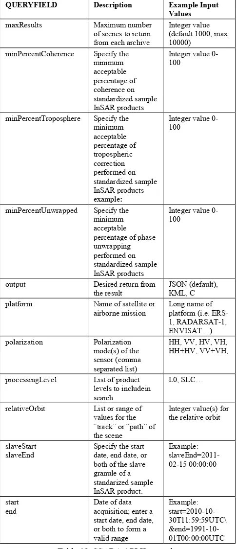
4.4 API Keywords
QUERYFIELD Description Example Input
Values absoluteOrbit List or range of
values for the orbit number earliest scene in a stack
Integer value for baseline
beamMode Operating mode(s) of the sensor (comma separated list)
Fine, Standard, Wide Swath
beamSwath Swath name(s) of the sensor (comma separated list)
ST1, ST2,…FN1, FN2, …
collectionName List of collections to include in search
WInSAR, faraday rotation of a scene
Float value for the faraday rotation
flightDirection Specifies the direction the platform is traveling
A or D
frame List or range of values for the frame number of the scene
Integer value(s) for
intersectsWith Geographic area of interest for the
QUERYFIELD Description Example Input Values maxResults Maximum number
of scenes to return from each archive
Integer value (default 1000, max 10000)
minPercentCoherence Specify the minimum
minPercentTroposphere Specify the minimum
minPercentUnwrapped Specify the minimum
output Desired return from the result
JSON (default), KML, C platform Name of satellite or
airborne mission
processingLevel List of product levels to includein search
L0, SLC…
relativeOrbit List or range of values for the start date, end date, or both to form a Table 12. SSARA API Keywords.
4.5 Resources
1. SSARA SAR Service:
http://www.unavco.org/ws/brokered/ssara/sar/search 2. SSARA InSAR Pair Service:
http://www.unavco.org/ws/brokered/ssara/insar/selectpairs 3. SSARA InSAR Product Service:
http://www.unavco.org/ws/brokered/ssara/insar/search 4. DEM Service: http://ot-data1.sdsc.edu:9090/otr/getdem 5. Tropospheric Service: http://oscar.jpl.nasa.gov
6. SSARA GitHub Page:
https://github.com/bakerunavco/SSARA 7. SSARA GitHub Wiki:
https://github.com/bakerunavco/SSARA/wiki 5. REFERENCES
ACKNOWLEDGEMENTS
This work was made possible by the 2011 NASA ROSES ACCESS Program (NASA Proposal Number 11-ACCESS11-0035).
InSAR Product, SSARA software, testing, and documentation contributions provided by Rudi Gensb, Tim Sternb, Kirk Hogensonb, and Greg Moorec.
REFERENCES
Crosby, C., Arrowsmith, J., Nandigam, V., Baru, C., 2011. A Geoinformatics Approach To Online Access And Processing Of LIDAR Topography Data. In: Geoinformatics, R. Keller and C. Baru, eds., Cambridge University Press, London.
Hanssen, R., 2001. Radar Interferometry: Data Interpretation and Error Analysis. Kluwer Academic Publishers.
Krishnan, S., Crosby, C., Nandigam, V., Phan, P., Cowart, C., Baru, C., and Arrowsmith, J., 2011. OpenTopography: a services oriented architecture for community access to LIDAR topography. In: Proceedings of the 2nd International Conference on Computing for Geospatial Research &
Applications (COM.Geo '11), AMC, pp. 8.
DOI=10.1145/1999320.1999327
Pepe, A. and Lanari, R., 2006. On the extension of the minimum cost flow algorithm for phase unwrapping of multitemporal differential SAR interferograms, IEEE Trans.
Geosci. Remote Sens., 44, 9, pp. 2374-2383.
Youn, C.,,Nandigam, V., Phan, M., Tarboton, D., Wilkins-Diehr, N., Baru, C., Crosby, C., Padmanabhan, A., and Wang, S., 2014. Leveraging XSEDE HPC resources to address computational challenges with high-resolution topography data. In Proceedings of the 2014 Annual Conference on Extreme Science and Engineering Discovery Environment (XSEDE ‘14). ACM, New York, NY, USA, , Article 59 , pp 2. DOI=10.1145/2616498.2616564
Li, Z., Fielding, E. J., Cross, P., and Muller, J.-P., 2006, InSAR atmospheric correction GPS Topography- dependent Turbulence Model (GTTM): Journal of Geophysical Research, v. 111, pp. B02404. DOI:02410.01029/02005JB003711. Li, Z., Muller, J., Cross, P., and Fielding, E., 2005, InSAR atmospheric correction: GPS, MODIS and InSAR integration: Journal of Geophysical Research, v. 110, p. B03410. DOI:03410.01029/02004JB003446.
von Allmen, P., Fielding, E., Fishbein, E., Li, Z., Xing, Z., Pan, L., 2011. OSCAR: Online Services for Correcting Atmosphere
in Radar.