Volume 3 Nomor 2, Agustus 2015, 131-150 http://dx.doi.org/10.14710/jwl.3.2.131-150 Journal Homepage: http://ejournal2.undip.ac.id/index.php/jwl
The Community
–
Based Flood Disaster Risk
Reduction (CBDRR) in Beringin Watershed in
Semarang City
Tiara Sartika Worowirasmi
1Kementerian Pekerjaan Umum dan Perumahan Rakyat Jakarta, Indonesia
Miun Edi Waluyo
Badan Penanggulangan Bencana Daerah (BPBD) Provinsi Jawa Tengah Indonesia
Yuliana Rachmawati
LSM Bintari Semarang, Indonesia
Itsna Yuni Hidayati
Initiative for Regional Development and Environmental Management Semarang, Indonesia
Artikel Masuk : 22 Juni 2015 Artikel Diterima : 19 Agustus 2015 Publikasi Online : 31 Agustus 2015
Abstract: Population growth in Semarang city is certainly increasing land demand for settlement. Limited land and weak regulation enforcement of land control trigger the land use change including the watershed area. Semarang City Spatial Plan 2011-2031 has determined Beringin as a buffer area with limited physical development allocation but the citizens utilized the watershed area for settlement. Settlement developments in the area reduce the watershed ability to catch water and river capacity due to increased sedimentation. These two reasons are the main cause of the flash flood disaster (regularly in rainy season) in seven villages of Beringin watershed. The condition is exacerbated by the tidal flood occurred in two village lies in coastal. In 2012, Semarang City government developed Flood Forecasting and Warning System as one of Climate Change Adaptation Measures known as Flood Early Warning System (FEWS). One of important output of FEWS is community-based disaster risk reduction. Community participation process in the FEWS has made it possible for the community to identify disaster risk characteristics, to propose solution for reducing flood risk which is suitable to the local wisdom, to increase the community capacity and to organize one of themselves in a disaster preparedness group which run quite independently.
Keywords: Community-Based Disaster Risk Reduction, Flood, Community Disaster Preparedness Group
Introduction
This article raised the experience of the community-based disaster risk reduction CBDRR (Pengurangan Risiko Bencana Berbasis Komunitas) in Beringin watershed. The disaster risk reduction approach cannot be solved by a group or organization (Twigg, 2009). The disaster risk reduction is a complex problem which requires a joint effort from the various stakeholders, including a community effort.
The CBDRR activity is a direct form of disaster risk reduction effort, which are primarily designed by people in at-risk localities and are based on their urgent needs and capacities (Victoria, 2002). The CBDRR approach focuses on the local community participation. They are the first team to perform emergency responses at the household and community scale. The local communities who suffer and withstand the most of disaster impact, which become a reason. The speed and effectiveness of the disaster response relies heavily on the role of the local community (Willison 2006; Satterthwaite, 2011). The aim of CBDRR is to reduce vulnerability and increase the capacity of vulnerable people, to be able to overcome or prevent or minimize the loss and damage, property and the environment, and to minimize the human suffering and boosting the recovery (Victoria, 2002; Mercy Corps, 2010).
The CBDRR approach tries to correct deficiencies of the top-down approach of disaster management. The top down approach fails to accommodate the local needs, ignoring the potential of local resources and capacity, and perhaps the top-down approach can increase the vulnerability of the community (Victoria, 2002). Nevertheless, the combination of the top-down and bottom-up approaches are better for the urban disaster risk management (Tingsanchali, 2012).
On November 9, 2010, the flash floods devastated settlements along the Beringin watershed with the height of flood as high as 1.5 - 2.5 meters. It caused six causalties and more than 100 houses in five villages were flooded and other material losses (Suara Merdeka, 2014). The conversion of the green open spaces or forests in the western part of Semarang City, particularly in the Ngaliyan and Mijen Districts, into housing areas was a significant cause of the flooding. Poor management of the drainage system also contribute to increase flood risks. Furthermore, climate change has significanly increased in precipitation, although it is only in shorter duration.
The Semarang city government has done some structural mitigation such as river normalization and built a river dike in order to reduce the flood risk in Beringin watershed. Apart from the structural effort, the non-structural mitigation is done through a land use policy implementation. While those efforts are being carried out, in 2012 the Government of Semarang implements FEWS program as the non-structural mitigation in a framework of disaster preparedness.
FEWS is the multi-year program (2012-2014) derived from the Rockefeller Foundation grant. Semarang City selected as the location of program implementation based on the membership of Asian Cities of Climate Change Resilience Network (ACCCRN). The partnership of Semarang City Government, Diponegoro University, Mercy Corps Indonesia and BINTARI Foundation (a non-governmental organization) implemented the program.
specific at every stage of CBDRR, we tries to convey the important lessons from program implementation.
The Information Collection Methods
We observed seven sub districts in Beringin watershed during 2012-2014. The information was obtained while we involved in CBDRR activities such as participatory mapping process, socialization of disaster awareness cultural understanding, focus group discussions, formation of the KSB and community groups, capacity building process of the KSB, table top exercise, emergency response simulation and evacuation simulation. In addition to this process, additional information is obtained from the informal interaction through some interviews and conversations which were needed in field notes.
The Basic Concepts
A disaster is a serious disruption of the functioning of a community or society which resulted in losses and the widespread impact of human, material, economic and environmental. The loss and impact of such disasters exceed the capabilities of community/society to overcome using their own resources (ADRRN, 2009). The definition
of a disaster in accordance with the Law 24, 2007 on Disaster Management is “an event or
series of the events that threaten and disrupt the lives and livelihoods caused by both natural and or non-natural factors or human factors that resulted in human fatalities, environmental damages, the loss of properties, and psychological impacts".
Disasters can be caused by natural hazards and man-made (Khan et al, 2008). The natural hazards are caused by natural phenomena such as rain storms, hurricanes, drought, tsunami, landslides, earthquakes, volcanic eruptions, etc. The other hazards can be caused by human negligence, for example: a nuclear reactor leakage, disposal of hazardous materials, pollution, dam leakage, deforestation, war, social conflict, etc. The disaster hazards from the combination of natural factors and man-made such as: landslides, floods, droughts and fires (e.g. floods are caused by heavy rainfall which is combined by deforestation/the land use changes).
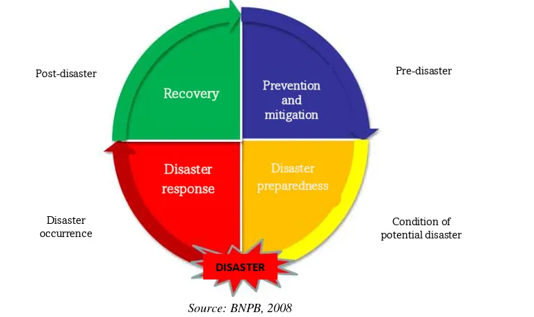
The disaster management consists of four stages, they are prevention and mitigation, disaster preparedness, disaster response and recovery (see figure 1). Each explanation of the stages (Peraturan Kepala BNPB No.4, 2008) as follows:
a. Prevention and mitigation stage
The activity is aimed to prevent disaster and reduce disaster risks. The mitigation action is classified into passive and active. The examples of passive mitigation are creating disaster management plans, policies, and studies. Meanwhile the examples of active mitigation are increasing the disaster preparedness of the community and infrastructure development to reduce disaster risk.
b. Disaster preparedness stage
This stage purpose is anticipating the disaster possibility which can cause the loss of life, property and changes in people's lives. The preparedness efforts are carried out when initial disaster sign appear. The example activities such as activation of disaster emergency response center, creating a disaster response planning, preparation of information and communication systems to support disaster task, etc.
c. Disaster response stage
disaster victims, determinate disaster emergency status, immediate recovery of vital facilities and infrastructure, etc.
d. Recovery stage
This stage consists of rehabilitation and reconstruction activities. Rehabilitation purpose is restoring post-disaster condition to a better condition, so the lives and livelihood of the community return to normal. The examples of recovery are environmental recovery in disaster area, public facilities and infrastructure recovery, health care provisions, etc.
Source: BNPB, 2008
Figure 1. The Disaster Management
The reconstruction strategies is rebuilding the damaged infrastructure into better condition and suitable for living. This stage should be done by an expert assessment through better planning and related sectors in advance. The examples of reconstruction stage are the reconstruction of social, the improvement of public services, the implementation for a better design and resistance to disaster.
Disaster risks defined as the potential loss caused by disasters in an area and period of time. The disaster risks are casualties, injury, illnesses, soul threatened, the loss of secureness, evacuation of, damage or the loss of property, and the disruption of the community activities (UU RI No. 24, 2007). The disaster risk management is the overall actions which can be taken up before, during and post- disaster in order to avoid or reduce its impact or recover from its losses (Khan et al, 2008). The implementation of CBDRR is an active mitigation of disaster risk reduction.
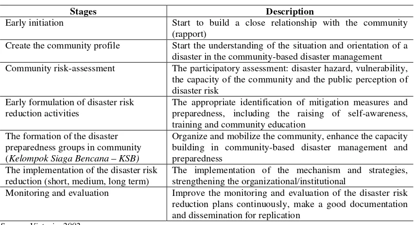
The CBDRRhelps the community in transforming from living with the disaster risk to a community who “accustomed” and "intelligent" in facing the disaster. The stages of transformation vary from one society to the other. However the CBDRR stages can be generalized as shown in table 1.
Prevention and mitigation
Pre-disaster
Condition of potential disaster Disaster
occurrence Post-disaster
Recovery
Disaster response
DISASTER
Table 1. The Stages of the CBDRR Forming
Stages Description
Early initiation Start to build a close relationship with the community
(rapport)
Create the community profile Start the understanding of the situation and orientation of a disaster in the community-based disaster management Community risk-assessment The participatory assessment: disaster hazard, vulnerability,
the capacity of the community and the public perception of disaster risk
Early formulation of disaster risk reduction activities
The appropriate identification of mitigation measures and preparedness, including the raising of self-awareness, training and community education
The formation of the disaster preparedness groups in community (Kelompok Siaga Bencana – KSB)
Organize and mobilize the community, enhance the capacity building in community-based disaster management and preparedness
The implementation of the disaster risk reduction (short, medium, long term)
The implementation of the mechanism and strategies, strengthening the organizational/institutional
Monitoring and evaluation Improve the monitoring and evaluation of the disaster risk reduction plans continuously, make a good documentation and dissemination for replication
Source: Victoria, 2002
The Results and Discussion
Flood Characteristics in Beringin Watershed
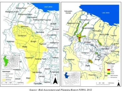
Beringin watershed is about 26.46 km2 wide and mostly the topography is hilly. In the downstream part of the topography is relatively flat, the height about 0.75 – 12.5 meters above sea level. In the upper part, the height about 12.5 – 250 meters above sea level (Hakim & Al-Mukaffa, 2005; Susilo & Sudarmanto, 2012). The west part of the Beringin watershed is continuous to the Plumbon watershed, meanwhile on the east part of Silandak watershed.
The Beringin river comes from a set of small river which is located in Mijen District. It flows through several areas of the sub-districts and ends into the Java Sea (see Figure 2 Location Beringin watershed). In its stream, several creeks both natural and artificial join because of the establishment of settlements or other form of designation.
According to the elder people of the Wates and Wonosari sub-district in Ngaliyan district, they said despite the heavy rain, their village never flooding even in the peak of the rainy season until the end of the 1980s. Along with the establishment of a large residential area on Beringin watershed, in the mid of 1990s the flood flash began to occur during the rainy season. The peak of Beringin watershed flood occurred in November 9, 2010. The flood caused Pantura traffic disruption which serves as a national road. It happened at the Wonosari bridge, Mangkang. Semarang-Jakarta railway lines also submerged and cannot be passed by the train until several days.
Source: Risk Assessment and Planning Report FEWS, 2012
Figure 2. Beringin Watershed Location and Flood Area
In order to reduce the flood risk in Bering Watershed, the Semarang city government has done some structural management through river dredging (Suara Merdeka, 2004), normalization efforts (Safuan, 2014) and improve the dikes in the Beringin River (Suara Merdeka, 2014). The implementation of the land use control policy is a non-structural effort measure. While such efforts are made, in 2012 the FEWS program was implemented in order to improve the community preparedness against the floods and build a flood early warning system in Beringin watershed.
The Stages of the Beringin Watershed CBDRR
Figure 3. The Process of CBDRR Implementation on FEWS Program
Early Initiation
The early initiation is aimed to build a trust with the local communities. If the local community has trusted "outsiders", they will open to share the issues, problems, concerns and solutions to solve their problems (Abarquez & Murshed, 2004). This stage was implemented from June to October 2012, proceded by a series of focus group discussions and participatory mapping. This activity resulted in the identification of the flood hazard monitoring method, the information process of the dissemination flash floods and tidal warning (especially tidal in Mangunharjo – Mangkang Wetan sub-district), as well as the evacuation process.
The introduction and involvement of the community figures, which are active in the disaster response activities is a process that must be done in the early of the initiation stage. The community leader is the primary source of the local wisdom information. The local wisdom introduction is very useful, because it can be transferred and adapted to the other communities, increase the participation and community empowerment, and increase the adaptation interventions in the local context, sometimes beyond the formal knowledge about the natural hazard (Mavhura et al, 2013).
The FEWS program implementers and communities identify the local wisdom of the community in facing of their previous flood disaster (Waskitaningsih, 2012) as shown in table 2. The flood had occurred in a very long time in their area, so that the community has to adapt and pass the local wisdom and experience from generation to generation.
Table 2. The Local Wisdom of Beringin Watershed Community
Main Activity The Local Wisdom The flood and tidal
hazard monitoring
The community estimates the flood hazard through the intensity and duration of the rain
Main Activity The Local Wisdom
group and Wonosari Disaster Concern Group (Kelompok Peduli Bencana Wonosari).
Tidal is estimated by the Javanese calendar system. It usually occurs in the early month with varied at the heights. It reached the peak in the ninth month (Javanese calendar) or in May (Gregorian Calendar) The communication
methods in informing flood and tidal
1. Community to community
The river water level information is delivered through short message services, phone calls, mosque loudspeakers, hit the electric pole/Javanese wooden sirens/mosque bedug and also people yells about flood hazard.
2. Community to government
The community sends the flood information to the authorized institution such as social services, districts office and police stations based on the personal close relationship and related institution of the disaster through short messages and phone calls
The evacuation process There is no a structured evacuation system.
The temporary shelter/meeting point is placed in higher ground and safe from the flood.
The temporary shelter/meeting point uses private homes and public facility such as sub district office hall, schools and mosques.
The public kitchen use home, which is near the temporary shelter /meeting point
The evacuation track uses the sub district road or main road which is free from the flood
The rope and life boat are used as a tool to make the evacuation process much easier
Source: Excerpted from Waskitaningsih, 2012
The disaster response system in Beringin watershed does not have a clear mechanism (refers to table 2). According to the community, the disaster response actions are not effective to reduce the flood risk. In fact, the people rely on a sense of mutual cooperation as part of the culture and local wisdom (Fatoni, 2010). The mutual cooperation in a disaster response enhances the positive values such as the social harmony and mutual relationships in the disaster prone areas. The mutual cooperation provides a motivation to withstand towards the suffering caused by the disasters and all involves in the disaster itself (Mardiasmo & Barnes, 2013).
Individualistic values emerged, so that the orientation of idea and action during the emergency response is only for themselves or their families, but not the community. This condition is not optimal to overcome the common problems in disaster risk reduction action. It needs more attention to explore the values of the cooperativeness in its place through planning the preparedness action together. This measure expected to reduce the disaster impact.
The monitoring and evaluation team of FEWS program had concluded the initial focus group discussions and participatory mapping results were not optimal. Those are resulted the assignment of the community development team to explore the identification result and make a further assessment of the disaster risks in each sub district. This step was done with depth interviews of local figures in disaster response as well as field observations.
The Formation of the KSB and the Community Groups
disaster preparedness community group increases the resilience of the communities in facing the disasters and has a function to mobilize a larger community, including their own resources (Victoria, 2002).
Prior to the formation of the KSB, the Beringin watershed sub-district has had some local elites and groups of activists who are active in disaster response activities, such as
MUAL’S (Munggah Alas Sak Dhuwure – a group of youth who appreciate environment, enjoy outdoors activity) Mangkang Wetan – Mangunharjo, Kelompok Masyarakat Peduli Bencana (KMPB) Wonosari, the community volunteers which are members of the Red Cross and Semarang Tanggap Bencana (Semargana – Semarang Disaster Response) and Youth Group.
The community development team approaches the local elites and activities groups, provide information about the FEWS program objectives and give the understanding the importance of the KSB as a main subject of the CBDRR. The KSB formation is not top-down approach, which is the urgency of its formation, the assignment of responsibilities and the division in the KSB was handed over to the community decision.
The people in all sub districts have understood the KSB to be very important for them. In the process, the KSB members are proposed or mapped by the community figures. Each of the sub-district has its own agreement to assign the tasks and responsibilities of the KSB. The KSB has the structural organization which has been legalized by the Decree of the District. The KSB serves as the coordinators and implementer of the CBDRR in each sub-district.
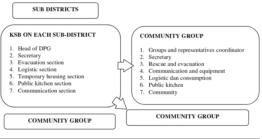
The community development team and the KSB make an evacuation scenario and form a community group. The term of "community group" is the KSB at the community level, which is grouped by the community agreement, an administrative unit (RT or RW) of residential units, based on evacuation path or site or group of social activities (example:
pengajian group or recitation group of Moslems). This community groups are managed by the KSB, it is composed from the KSB members and volunteers to fill the coordination structures (Figure 4). The KSB in the community level is assigned to assist the sub district particularly in disaster response.
Only four sub districts in Beringin watershed have the community groups, they are Wates, Wonosari, and Mangkang Wetan – Mangunharjo (it is rolled into one group because
of its adjacent location). The community group is formed by the person’s willingness, the
number of people who affected by flooding, flood risk and the KSB or society eagerness in follow individuals or group training.
It is very important to map out and understand the internal condition of the community when we divided the community groups. Some examples of the conditions such as:
1. The internal conflicts related to the public administrative division (RT, RW even sub- district border)
2. The selection of temporary shelter based on neighbors or relative’s connection.
Figure 4. The Structure of the KSB Coordination and Community Groups
Some of the patterns are found in the establishment of the management groups: 1. The group coordinator is a respected individual/elderly people or individuals who
active in the disaster response before the FEWS program.
2. The rescue and evacuation division is filled with youth who active in social activities. 3. The public kitchen consists of women who are active in social activities.
The gender representation is considered in the establishment and management of the KSB and the community group. In accordance with Hyogo Framework (ISDR, 2005) the education and training for the disaster risk reduction must guarantee the equal access for women and vulnerable groups. Fothergill (1999) and GOI-UNDP (2009) stated that recently, women have increased their role in the disaster. They want to perform the tasks that are usually performed by the men. The involvement of women's role in the previous flood events of Beringin watershed was in the public kitchen.
After the training process of KSB and evacuation simulation, women make some suggestions for training on the disaster risk reduction through empowerment forums and family welfare (Pemberdayaan dan Kesejahteraan Keluarga – PKK) and pengajian group (recitation group of Moslems). They do not only want to get involve in the public kitchen, logistics or administration, but also to have their own basic ability to evacuate themselves and their families.
The KSB formation in Beringin watershed is combined with the formation of the disaster resilience sub-district, which is programmed from BPBD Semarang. After the FEWS program finished, the KSB Beringin watershed will be under the guidance of BPBD Semarang. Thus, the strengthening of the capacity and the implementation of CBDRR can be carried on.
The Upgrading of KSB and Community Capacity
The community training on the disaster is a form of non-structural disaster. The training aimed to increase the capacity of communities and help them to understand the forms of the disaster risk reduction (Kafle & Murshed, 2006). The KSB training was conducted in five different days of training in 2013. The trainer was from BPBD Semarang,
SUB DISTRICTS
KSB ON EACH SUB-DISTRICT
1. Head of DPG 2. Secretary
3. Evacuation section 4. Logistic section
5. Temporary housing section 6. Public kitchen section 7. Communication section
COMMUNITY GROUP
1. Groups and representatives coordinator 2. Secretary
3. Rescue and evacuation
4. Communication and equipment 5. Logistic dan consumption 6. Public kitchen
7. Community
BPBD Central Java Province, Semarang City Health Office, Semarang Red Cross, Search and Rescue Department and Diponegoro University. The KSB training material includes: 1. Introduction: disaster management, flood preparedness and disaster mitigation.
2. Flood early warning: early warning, utilization and maintenance of early warning instruments, field observation and practice on using and maintaining early warning system instruments.
3. Rescuing, evacuating and logistics.
4. Utilization of equipment of rescue tools, communication tools. 5. Health and assistance and first aid.
6. Recovery process of post-disaster.
The material is delivered by a variety of methods, such as lecture method, discussion, focus group discussion and field practice. Delivery of the material should minimize the lecture methods, the community would prefer to get involved in the discussion and practice.
The trainer builds close relationship with the participants, for example by using easy language in delivering the materials or using of Javanese language. This approach should be done considering the participants came from diverse educational backgrounds and the majority of them is Javanese. The trainer asked the participants about their previous encounter with disaster. They use the information to explain what should be done and should not be done in facing such a situation.
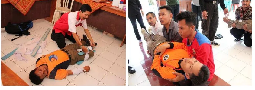
The KSB got field training before the evacuation simulation. The field training is a compulsory material for the KSB and the community level, especially for the communication and rescue division. The field training includes the usage of the Handy Transceiver (HT), the communication procedure, the usage and maintenance of the early warning system equipment and the simulation of rescuing a flood victim (see figure 5).
Figure 5. The KSB Training on 2013
Wonosari is an active sub-district. They are the most attended participant from 7 affected sub districts. In fact, this sub district received the worst and the wider impact of the flood impact. Drabek (1986) in Pearce (2003) states that the disaster impact which hit the community severely will raise the awareness of the community, they will more active in the training in order to increase their ability in facing the disaster.
involvement of women and youth is increasing significantly at the end of the program, especially in the evacuation simulation.
The community organizing in the training is a challenge of CBDRR approach. There are values and rules in society that should be respected by the external party or facilitator (Victoria, 2002). The community development team conducted mapping and using the social activities in each of sub-district (for example: monthly gathering, recitals for Moslems, the PKK, the citizens meeting and the youth organization) as an opportunity to embed the program meeting. It’s also an opportunity between the team and the community to determine the training schedule. The community development team should consider working hours, social activities and holiday or weekend as a family day.
With the limitation of the time and funds, the KSB may not understand the training material optimally. Training evaluation show the community tends to do practical and applied training when the flood disaster take place, such as rescue flood victim and valuable objects, communication equipment, and even they proposed the swimming training.
The flood disaster almost occurs every year in Beringin watershed. The KSB needs to refresh the flood disaster response training before entering the rainy season. The KSB can cooperate with the facilitator such as Red Cross, BPBD and Search and Rescue (SAR) Department to guide them in training.
The Communication and Coordination on the Early Warning System (EWS)
The communication and coordination play an important role in the EWS in Beringin watershed. UN-ISDR (2009) defines the early warning as "The set of capacities needed to generate and disseminate timely and meaningful warning information to enable individuals, communities and organizations threatened by a hazard to prepare and to act appropriately and in sufficient time to reduce the possibility of harm or loss".
UN-ISDR introduced the EWS scheme which should be community oriented, integrates and include four elements. They are the knowledge to face the risk; the warning and monitoring; the dissemination of the important information to those who affected by the disaster risk and response in accordance with the community self-awareness and preparedness (Seng, 2012).
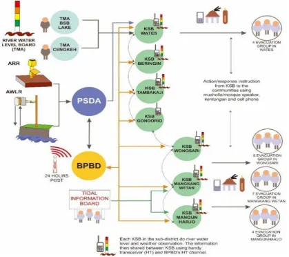
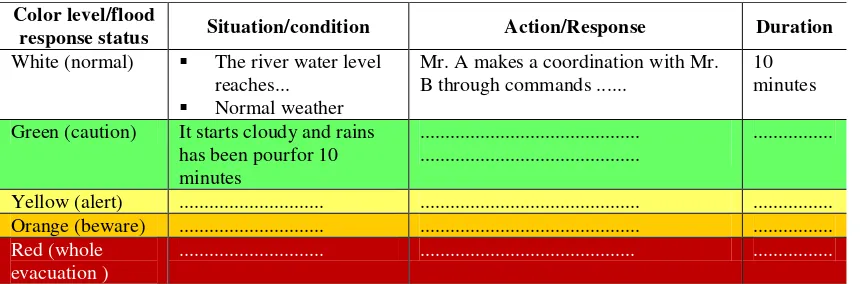
The communication and coordination mechanism of the KSB Beringin watershed is related to EWS and a contingency plan. The EWS in Beringin consists of flash and tidal flood. The EWS of flash flood was resulted from the Beringin watershed flood modeling. The EWS instrument uses the automatic and manual instruments. The automatic and manual EWS of flash flood is assigned to use the color levels and the flood response status (white – normal; green – caution; yellow – alert; orange – beware; red – whole evacuation).
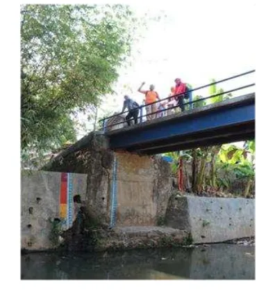
Figure 6. The River Water Level Board TMA at Tikung Bridge Wonosari
The EWS of tidal flood is given in the form of a tidal flood prediction information board only for Mangkang Wetan and Mangunharjo Sub-districts. Figure 7 shows the scheme of the communication and disaster response coordination watershed flood Beringin. The information board contains:
1. Tides prediction map with color level.
2. Tides forecasting table of Semarang City, published by Directorate of Hydro-Oceanography (DISHIDROS) Indonesian Navy.
3. Tides forecasting table result from field observation in Mangkang Wetan and Mangunharjo Sub-districts.
Why they have to use two approaches, automatic and manual? The community at present cannot fully rely on the automatic EWS, there is a possibility the instrument does not correspond to the field conditions and they afraid it may be defected. The KSB requires a visual observation in order to provide the information in the real condition. The automatic EWS become the supporting device, meanwhile the manual EWS act as the backbone of the communication in the KSB.
Figure 7. The Scheme of the Communication and Disaster Response Coordination Watershed Flood Beringin
The Contingency Plan
On flood emergency response condition, the community groups need a contingency plan to minimize the disaster risk. The plan is intended to develop the strategies and procedures for responding to the potential crisis or emergencies that will occur (Vidiarina, 2010). The contingency plans are characterized as follows: a participatory development process, focus on a single hazard, a plan based on a scenario, scenarios and objectives are developed from the general consensus, non-confidential, roles and responsibilities are identified and made to handle the emergency situation.
Wates, Wonosari, Mangkang Wetan, Mangunharjo Sub-districts had established the community-level contingency plan. The community development team made the evacuation map with KSB and the representatives of the community. The main information on the map is the house location (including the family members), evacuation path and temporary shelter (either the community house or public facilities which are often used by people to evacuate).
The contingency planning process was done through the community figures and community meetings. The frequency of the meeting is adjusted to the community schedule. The main information about the plans are:
1. The division of the community groups.
3. The evacuation map and the temporary shelter. coordination with the external institution (BPBD Semarang, PSDA-ESDM Semarang and district/sub-district office).
Table 3. The Example of Scenarios in the Community Contingency Plans Evacuation
Color level/flood
response status Situation/condition Action/Response Duration White (normal) The river water level
reaches... Normal weather
Mr. A makes a coordination with Mr. B through commands ...
10 minutes
Green (caution) It starts cloudy and rains has been pourfor 10
Source: the FEWS Community Contingency Plan Program, 2014
The contingency plan in the four sub districts is for single hazard (flood flash disaster) and applied locally. The availability of this plan ensures quick response better than waiting the aid from the government or other institution. The contingency plan is dominated by the community role. Meanwhile, the government of Semarang City is responsible as the party who gives the information, the function of coordination and provides the aid when the communities are not able to cope with the emergency response with their own resources.
The community contingency plan is a living document that requires an appropriate update in accordance with the dynamics and challenges in the field. The community preparedness action based on the contingency plan depends on the succession of the KSB
new members or the community group’s personnel. This succession is expected to be fostered by the disaster expert from BPBD, the Disaster Risk Reduction Forum Semarang and relevant stakeholders.
Table Top Exercise (TTX), Evacuation Simulation and Contingency Plan Dissemination
The TTX exercise is an activity a group of people to review and discuss the plan for the emergency situation step by step to determine the effectiveness of the individual or
institution’s actual response to an emergency situation (Dekalb County Advanced Practice
Center, 2007). The TTX enables stakeholders to identify the strengths and plan deficiencies, discuss the policy, resources, communication, coordination, data management, and other aspects of the emergency preparedness (Dekalb County Advanced Practice Center, 2007). There are two methods: basic and advanced TTX (Emergency Management Ontario, 2010). The TTX for the KSB FEWS is basic TTX. They do the exercise with a permanent evacuation scenario. The TTX is carried out by main the KSB members and the community level.
response situations. The community acts themselves as if the flood disaster has taken place.
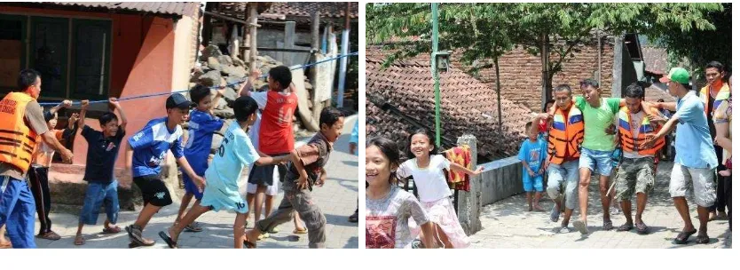
The simulation was performed with great enthusiasm by the community of all ages. They mobilize volunteers, youth groups and women to help the rescue, logistics and public kitchen division. The KSB misconduct can occur when the simulation takes place, as for example the procedures in addressing victim is less than perfect or hastily giving instructions. It becomes a normal part of the simulation process.
During the simulation, the FEWS program management team assisted by disaster experts from the BPBD Central Java Province and the Asian Disaster Preparedness Center (ADPC). They make observations without intervening the simulation process or perform corrective action of KSB and the community. The full-scale simulation is ends with the evaluation in order to provide improvement of the contingency plans.
Figure 8. The Simulation Activities of FEWS Program 2014
This activity should be carried out before the rainy season, so they are prepared for the next possibility of a flood disaster. The community and KSB can do a gathering to discuss the development of contingency plans. In this gathering, KSB ensures the proper equipment or logistics and increases the capacity or skill of KSB members and the
community group’s personnel.
The dissemination of contingency plan is a compulsory step in CBDRR approach. The KSB is considered to have the capacity and ability to present the contingency plans. The dissemination of the contingency plan has been carried out in elementary school and junior high school located in Beringin watersheds area, the recital Moslems group, the PKK
forums and activities which is associated with the community, such as the RT and RW
meeting. The way we deliver the contingency plan should adjust to the audience. As the example, for pupils receive enrichment the importance of flood preparedness through film, posters and interactive activities between teachers and students, so we can gain their interest in the flood response activities.
Conclusion
Gradually, the community is brought to the contingency plan simulation in accordance with the community resource. Some examples of the local wisdom in the contingency plan such as: the usage of a Javanese wooden siren or a mosque loud speaker as a means of the early warning system instrument, the evacuation path using the existing road, the temporary shelter are chosen by the community (using a house they have ever used as an evacuation place).
The FEWS program is meant to be independent, so after the program is completed the local community can maintain and develop their disaster risk reduction measures, the skills that have been mastered and the basic infrastructure were built in FEWS program. At the end, if the community is self-sufficient and not depending entirely on the external institution (for example: government, private sector) we may conclude the CBDRR goal is reached.
Acknowledgements
The result of this article is one of the FEWS Semarang output program funded by the Rockefeller Foundation. We express our gratitude to the entire partners of the FEWS program: Asian Cities Climate Change Resilience Network, Mercy Corps Indonesia, Bappeda Semarang, BPBD Semarang, PSDA-ESDM Semarang, BINTARI, Diponegoro University (Department of Civil Engineering and Department of Urban and Regional Planning Engineering) and all the community in seven sub districts of Beringin watershed who has contributed during the program implementation
References
Abarquez, I. & Murshed, Z. (2004). Community-based disaster risk management-field practicioner’s handbook.
Retrieved from http://www.adpc.net/pdr-sea/publications/12Handbk.pdf.
Asian Disaster Reduction Response Network (ADRRN). (2009). Terminologi pengurangan risiko bencana. Retrieved from http://www.preventionweb.net/files/7817_isdrindonesia.pdf.
Badan Nasional Penanggulangan Bencana (BNPB) Indonesia. (2008). Peraturan Pemerintah (PP) Indonesia Nomor 21 Tahun 2008 Tentang Penyelenggaraan Penanggulangan Bencana. Jakarta: Badan Nasional Penanggulangan Bencana Indonesia.
. (2008). Peraturan Kepala Badan Nasional Penanggulangan Bencana Nomor 4 Tahun 2008 Tentang Pedoman Penyusunan Rencana Penanggulangan Bencana. Jakarta: Badan Nasional Penanggulangan Bencana Indonesia.
. (2011). Panduan perencanaan kontinjensi menghadapi bencana (Edisi Kedua). Jakarta: Badan Nasional Penanggulangan Bencana Indonesia.
Dekalb County Advanced Practice Center. (2007). Master the disaster! facilitator’s guide: How to plan, develop,
conduct and evaluate a tabletop exercise. Retrieved from
http://eprna.org/File%2004%20FacilitatorGuide.pdf.
Dellica-Willison, Z. (2006). Community-based disaster risk management-gaining ground in hazard-prone
communities in Asia. Retrieved from
http://asia- pacific.undp.org/content/dam/rbap/docs/Research%20&%20Publications/CPR/RBAP-CPR-SS-2006-Gaining-Ground-in-Hazard-Prone-Communities.pdf.
Emergency Management Orio. (2010). Guidelines for the development of an exercise program. Retrieved from https://www.emergencymanagementontario.ca/stellent/groups/public/@mcscs/@www/@emo/doc uments/abstract/emo_exerciseguidelines_pdf.pdf.
Fothergill, A. (1999). Women’s role in a disaster. Behavioural Science Review, 7(2),125-143.
GOI-UNDP. (2009). Good practices in community based disaster risk management, gender mainstreaming chapter. Retrieved from http://sdmassam.nic.in/pdf/publication/undp/gd_practices_in_cbdrm.pdf. Hakim, L. & Al-Mukaffa, M. (2005). Pengaruh perubahan tata guna lahan terhadap laju erosi dengan pendekatan
Sistem Informasi Geografis (SIG). Retrieved from
http://pilnas.ristek.go.id/karya/index.php/record/view/88843.
Irianto, G. (2014). Misteri banjir bandang. Tabloid Sinar Tani, 14 April. Retrieved from http://new.litbang.deptan.go.id/artikel/60/pdf/Misteri%20Banjir%20Bandang.pdf.
International Strategy for Disaster Reduction (ISDR). (2005). Hyogo framework for action 2005 – 2015: building
the resilience of nationas and communities to disasters. Retrieved from
http://www.unisdr.org/2005/wcdr/intergover/official-doc/L-docs/Hyogo-framework-for-action-english.pdf.
Kafle, S. K. & Murshed, Z. (2006). Participant’s workbook: Community-based disaster risk management for local authorities. Bangkok: Asian disaster preparedness center through its Partnerships For Disaster Reduction-Southeast Asia Phase 3 (PDRSEA3) Project jointly implemented by ADPC and UNESCAP with funding support from DIPECHO. Retrieved from http://www.adpc.net/pdrsea/pubs/curriculum-cbdrm.pdf.
Khan, H., Vasilescu, L. G., & Khan, A. (2008). Disaster management cycle – A theoretical approach. management & marketing. Craiova, 1, 43-50. Retrieved from http://www.researchgate.net/publication/46524908_Disaster_Management_CYCLE__a_theoretical_a pproach.
Mardiasmo, D. & Barnes, P. H. (2013). Community response to disasters in Indonesia: Gotong royong; A Double Edged-Sword. In Barnes, Paul H. & Goonetilleke, Ashantha (Eds.) Proceedings of the 9thAnnual Inter national Conference of the International Institute for Infrastructure Renewal and Reconstruction: Risk-infor med Disaster Management: Planning for Response, Recovery & Resilience, Queensland University of Technology, Brisbane, QLD. Retrieved from http://eprints.qut.edu.au/61482/.
Mavhura, E., Manyena, S. B., Collins, A. E., & Manatsa, D. (2013). Indigenous knowledge, coping strategies and resilience to floods in Muzarabani, Zimbabwe. International Journal of Disaster Risk Reduction, 5, 38-48. doi:10.1016/j.ijdrr.2013.07.001.
Mercy Corps. (2010). Established Community based early warning system: Practicioner’s handbook. Retrived from http://practicalaction.org/docs/nepal/Establishing-CBEWS-Practitioners-handbook.pdf
Pearce, L. (2003). Disaster management and community planning, and public participation: How to achieve sustainable hazard mitigation. Natural Hazards, 28, 211-228. doi:10.1023/A:1022917721797.
Pemerintah Republik Indonsia. Undang-Undang (UU) Republik Indonesia Nomor 24 tahun 2007 tentang Penanggulangan Bencana.
Safuan, A. (2014). Atasi banjir, pemkot Semarang kucurkan Rp 13,3 miliar. Retrieved from http://microsite.metrotvnews.com/indonesiamemilih/read/2014/01/16/926/208158/Atasi-Banjir-Pemkot-Semarang-Kucurkan-Rp13-3-Miliar.
Satterthwaite, D. (2011). Editorial: Why is community action needed for disaster risk reduction and climate change adaptation? Environment and Urbanization: International Institute for Environment and Development, 23, 339-349. doi: 10.1177/0956247811420009.
Seng, D. C. (2012). Improving the governance context and framework conditions of natural hazard early warning systems. Journal of Integrated Disaster Risk Management, 2, 1-25. doi: 10.5595/idrim.2012.0020.
Suara Merdeka. (2014). Normalisasi Beringin diminta dipercepat. Retrieved from
http://www.suaramerdeka.com/v1/index.php/read/cetak/2014/01/16/249445/Normalisasi-Beringin-Diminta-Dipercepat.
. (2004). Kali Beringin dikeruk selebar 10 meter. Retrieved from http://www.suaramerdeka.com/harian/0411/24/kot07.htm.
unaan_Lahan_Pertanian_dan_Lahan_Hijau_Menjadi_Pemukiman_di_Kota_Semarang_-_EDY_SUSILO,_BAMBANG_SUDARMANTO.pdf.
Tingsanchali, T. (2012). Urban flood disaster management. Procedia Engineering, 32, 25-37. doi:10.1016/j.proeng.2012.01.1233.
UN-ISDR (United Nations Inter-Agency Secretariat of the International Strategy for Disaster Reduction). (2009). UNISDR terminology on disaster risk reduction. Geneva: UN-ISDR. Retrieved from http://www.unisdr.org/files/7817_UNISDRTerminologyEnglish.pdf.
Victoria, L. P. (2002) Community based approaches to disaster mitigation. Proceeding Regional Workshop on Best Practices in Disaster Mitigation. Bali, 24-26 September 2002. Retrieved from http://www.adpc.net/audmp/rllw/PDF/CBDM.pdf.
Vidiarina, H. D. (2010). Perencanaan kontinjensi: Tinjauan tentang beberapa pedoman perencanaan dan rencana kontinjensi. kerjasama indonesia-jerman untuk Sistem Peringatan Dini Tsunami (GITEWS) peningkatan kapasitas masyarakat lokal. Jakarta: GTZ-International Services. Retrieved from http://www.gitews.org/tsunamikit/id/E4/sumber_lainnya/Perencanaan%20Kontinjensi%20%20Tinja uan%20tentang%20Beberapa%20Pedoman%20Perencanaan%20dan%20Rencana%20Kontinjensi.pdf. Waskitaningsih, N. (2012). Kearifan lokal masyarakat sub-sistem drainase Beringin dalam menghadapi banjir.
Jurnal Pembangunan Wilayah dan Kota, 8(4), 383-391.