GROUNDWATER FLOW AND ITS QUALITY
IN SHALLOW AQUIFER AT PRAPAK KULON,
SENDANGMULYO, MINGGIR, SLEMAN
T. Listyani R.A. & Kholilur Rohman Geological Engineering Department, STTNAS Yogyakarta
Sari
Dusun Prapak Kulon berada dalam wilayah DAS Progo, merupakan wilayah paling barat Kabupaten Sleman, dan termasuk dalam fisiografi gunung api Kuarter Merapi. Observasi hidrogeologi di lapangan menghasilkan beberapa data tentang kondisi akifer, muka airtanah serta sifat fisik/kimia airtanah yang diam bildari sumur-sumur penduduk. Hasil penelitian menunjukkan bahwa akifer dangkal yang menyusun daerah penelitian terdiri dari breksi dan batupasir vulkanik Formasi Yogyakarta yang termasuk bagian dari system Cekungan Airtanah Yogyakarta atau yang lebih dikenal sebagai Sistem Akifer Merapi (SAM). Zona akifer dangkal ini memiliki ketebalan 14 m, dengan kedalaman 2–16 m, dengan laju infiltrasi 0,8 – 4,82 cm/dtk. Muka airtanah berada pada kedudukan 118 – 132 m dpl, dengan arah aliran radial, dengan beberapa pola yang menuju kerucut depresi di bagian timur laut dan barat daya. Keasaman airtanah relatif normal hingga agak basa (pH 6,7 – 8,7) dan TDS 40 – 216 ppm, ke sadahan menengah.
Kata kunci: airtanah, akuifer, polaaliran,kualitas.
Abstract
PrapakKulon village which is located in Progo Drainage Area, is the most western region of Sleman District, and included in the physiography of Quaternary Merapi volcano. Hydrogeological observation in the field resulted some data about the condition of the aquifer, groundwater level as well as physical / chemical properties of groundwater taken from dug wells. The results showed that shallow aquifer in the study area consists of volcanic breccia and sandstonelayers of Yogyakarta Formation, which includes part of Yogyakarta Groundwater Basin system, better known as Merapi Aquifer System (MAS). The shallow aquifer zone has a thickness of 14 m and a depth of 2-16 m, with the infiltration rate from 0.8 to 4.82 cm / sec. Groundwater level is at the position of 118-132 m above sea level, with a radial flow direction, whereas some flow patterns go toward the depression cone in the northeast and southwest. Groundwater acidity is relatively normal to slightly alkaline (pH 6.7 to 8.7), while TDS range 40-216 ppm, moderately hardness.
Key word: groundwater, aquifer, flow pattern, quality.
1. Introduction
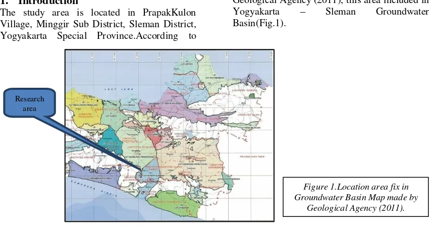
The study area is located in PrapakKulon Village, Minggir Sub District, Sleman District, Yogyakarta Special Province.According to
Geological Agency (2011), this area included in Yogyakarta – Sleman Groundwater Basin(Fig.1).
Research area
Figure 1.Location area fix in Groundwater Basin Map made by
Legend: Recharge area Transition area Discharge area Non aquifer group PrapakKulon Village geographically directly
adjacent to the Progo River, with the topography of the area is flat relatively, gentle sloping to the southwest. This village is located at the western part of Sleman District, as well as of Yogyakarta – Sleman Groundwater Basin.
Groundwater in Yogyakarta – Sleman Basin is usually abundant in quantitative, with relative shallow of dug wells. The groundwater table in this area sometimes varies in several meters, but in next area there can dug wells be found which has deep water. On the other hand, groundwater qualitatively is also variable. It can be found some samples of groundwater which have high enough turbidity. Therefore, groundwater potential in this area, both of quantitative and qualitative needs to be known in order to fulfill water demand. Some physical or chemical properties of groundwater should be measured, such as its value in pH and TDS.
2. Method
This research has been carried out by surface geological as well as hydrogeological mapping in the field. Research materials are topographic map, while tools of research are standards geological equipment (hammer, compass, loupe) and measuring tools of chemical properties such as pH meter and TDS meter in addition to some stationery. A bottle sample has been use to take dug well sample in order to analyze physical/chemical of groundwater.
3. Hydrogeological of Yogyakarta – Sleman Basin
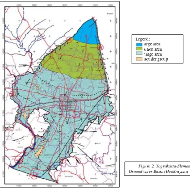
Yogyakarta-SlemanGroundwater Basin is located on the southern slope of Merapi Volcano, bounded by two major rivers, the Opak River in the east and Progo River in the west. In the southern part this groundwater basin is bounded by the Indian Ocean. Horizontal and vertical boundaries of Yogyakarta-Sleman Groundwater Basin in hydrogeology has been determined in accordance with the guidelines ofgroundwater basin determination (Hendrayana, 2013; Fig. 2).
Hydrogeological system formed by Yogyakarta and Sleman Formations in Yogyakarta-SlemanGroundwater Basin called Merapi Aquifer System (MAS). MAS was hydrogeologically formed the aquifer system, and consists of multilayer aquifers having equal hydraulic properties relatively and interconnected between one aquifer to another aquifers (Hendrayana, 1993, 1994, in Hendrayana, 2013). Based on the data and information can be obtained by the fact, that the Yogyakarta-Sleman Groundwater Basin aquifer
system is a free aquifer and semi free types which form a major aquifer system.
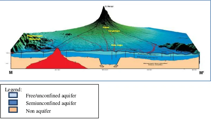
By grouping of hydrostratigraphic units in Yogyakarta-Sleman Groundwater Basin, then the existing aquifers can be divided into several hydrostratigraphic units, namely (a) Upper / Free Aquifer (Aquifer Group 1); (b) Bottom / Semi Free Aquifer (Aquifer Group 2) and (c) Basement of Aquifer / Group of Non Aquifer (Hendrayana, 2013). A sample of hydrostratigraphic cross section which pass the research area is shown inFigure 3.
Figure 3. East-west cross section of Yogyakarta-Sleman Groundwater Basin through the research area (Hendrayana, 2013.)
4. Data and Analysis
4.1. Type of Aquifer
The main rocks which consistYogyakarta-Sleman Groundwater Basin are Yogyakarta Formation at the top and Sleman Formation at
the bottom. Those rock
formationsarevolcanoclastic sediments of Mt.Merapi. Both of these formations serve as areMerapisediments which have very fine material (clay) to very coarse (boulder) grain size.
Soil on surface generally hasgrain size offine sand – clay. This clayey soil tends often causes slow infiltration process. Result of measurement in the field showed infiltration value of less than 1.2 cm / sec.Below the soil,
there are intercalated of volcanic breccia and sandstone.
Volcanic breccia rocks have grain size of gravel
– boulder fragments, and coarse sand – gravel for matrix, with floating textures. These rocks usually show low compacted – compact, with medium permeability. The upper part of stratigraphic of research area, volcanic breccia usually has been weathered which sometimes formed clay materials. The floating features, fragment floated between matrix, show that those sediments was resulted from turbidity current of Merapilaharic transportation. The infiltration rate measured in the field showed value of 1.2 m/sec or below.
cm/sec, even almost 5 cm/sec. With the enough thickness, these kinds of rocks are potential of
aquifers. This sandstone was produced by fluvial processes which intercalated laharic processes. Therefore, sandstone and laharic
sediments which consist stratigraphy of research area usually called by fluvio-volcanic sediments.
The infiltration rates of fluvio-volcanic sediments are usually low- medium. Infiltration process is the entry into the soil of water table made available at the ground surface, together with the associated flow away from the ground surface within the unsaturated zone (Freeze & Cherry, 1979). The low infiltration rate of clayey soil on surface sometimes decreases the rate of water down to subsurface.
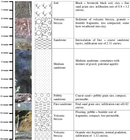
From the lithologic column (Fig. 4) it can be known that there is one aquifer zone which occurs at 2 – 16 m depth. This zone can be called as shallow/free/unconfined aquifer zone, with the thickness at least as thick as 14 m. The thickness of aquifer zone may vary from one place to another because the aquifer zone usually occurs as part of multilayer aquifers of MAS which often form lenses stratigraphy. The thickening/thinning of aquifers can occur locally. Besides that, the aquifer zone may be thinner to the west because the research area is located at the western margin of Yogyakarta-Sleman Groundwater Basin.
Figure 4.Lithologic column of research area taken from east part of Progo cliff.
Soil Black – brownish black soil, clay – fine boulder fragments, less compacted, some have weathered into clay.
Sandstone Intercalation of fine – coarse sandstone layers, infiltration rate of 2.31 cm/sec.
Medium sandstone
Medium sandstone, sometimes with mixture of gravel, potential aquifer.
Pebbly sandstone
Coarse sand – pebble grain size, compact, permeable.
Fine sandstone Find sand grain size, infiltration rate of4.82 cm/sec.
Volcanic breccia
Floating, pebble – boulder size of fragments, compact, less permeable.
Volcanic breccia
4.2. Shallow Groundwater Flow
Groundwater table map has been made based on its measurement in dug wells. Groundwater table in dug wells usually shows shallow depth, which is about at 5 – 12 m depth from the surface. Groundwater flows through this aquifer with variable direction locally (see Fig 5). In the research area there is two depression cones
which is located in the center and southwestern part area. Groundwater flows from higher hydrostatic head indicated by high groundwater table to the lower. Although groundwater flow regionally directs to the south, it shows vary also to the north and east in study area. This groundwater flow direction can change depends on the capacity of abstraction by local people.
Figure 5.Groundwater table map of research area.The arrow curves show groundwater flow direction.
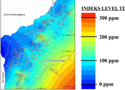
4.3. Quality of Shallow Groundwater
Groundwater quality data has been taken directly in the field from 77 dug wells using measuring devices of pH meter and TDS meter (Figure 6-7). The measurement results show the range of pH (acidity) of 6.7 to 8.4, while the value of TDS (Total Dissolved Solids) measured of groundwater ranges 40-216 ppm.It means that groundwater is relatively normal in
preferredrather than its reciprocal, resistance, because it increases with salt content. The low TDS of groundwater in study area refers fresh
water (<1000 mg/l) according to Carroll (1962, in Todd, 1980).
Figure 6.Acidity (pH) map of shallow groundwater in research area.
Unfortunately, one sample of groundwater which has been tested in chemistry laboratory shows hardness of 120.79 and turbidity of 23 NTU. According to Sawyer and Mc. Carty (1967, in Todd, 1980) this groundwater include in moderately hard class. Based on quality standards issued by The Health Minister (1990, in Wardhana, 1995) this hardness still proper for drinking water, but the turbidity is exceed the
Hydrogeological observation has been done at PrapakKulon, Sendangmulyo, Minggir Sub District, Sleman District. Result of observation show that there is one aquifer zone in research area. The aquifer zone is free/unconfined aquifer, consisted by Yogyakarta Formation which contains some layers of volcanic rocks like volcanic breccia and sandstone, with its thickness is at least 14 m. Some of them should be potential aquifers because of its good petrophysics (less compacted, medium-high permeability, medium infiltration rate). The depth of groundwater table in this aquifers usually shallow (about 5 – 12 m). Groundwater flows in many direction, both to north, south or east. The quality of this groundwater is good enough, with pH ranges 6.7 – 8.4 and TDS value range 40 – 216 mg/l. Based on the quality standard, this groundwater should be fit for clean or drinking water.
Acknowledgement
Our thanks would be appreciatedto the students of KKN STTNAS 2014/2015-2 especially who had worked in PrapakKulon. Thank you for your hard work in data collecting at the field so that this paper can be made properly.
References
Freeze, R.A. and Cherry, J.A., 1979, Groundwater, Prentice-Hall, Inc., Englewood Cliffs, New Jersey.
Hendrayana, H., 2013, CekunganAirtanah Yogyakarta – Sleman, Potensi, PemanfaatandanPengelolaan,
International Graduate Program in Geological Engineering, Faculty of Engineering, GadjahMada University, Yogyakarta.
Todd, D.K., 1980, Groundwater Hydrology, 2nd Ed., John Willey & Sons Inc., New York.
Van Bemmelen, R.W., 1949, The Geology of Indonesia, Vol. 1A, MartinusNijhoff, The Hague, Netherland.
Wardhana, W.A., 1995,