SURVEY, REPRESENTATION AND ANALYSIS OF A WORLD WAR I COMPLEX
SYSTEM OF SURFACE AND UNDERGROUND FORTIFICATIONS
IN THE GRESTA VALLEY - ITALY
I. Salvador*, A. Vitti*
* DICA, Università di Trento, Italy – (isabella.salvador, alfonso.vitti)@ing.unitn.it
KEY WORDS: Laser scanning, GIS, Cultural Heritage, Architecture, Representation.
ABSTRACT:
This work is part of a research on the use of terrestrial laser scanner, integrated with total station and GPS, for the documentation and comprehension of complex architectures in up-land sites. The research is performed in the framework of the project “Ambiente e Paesaggi dei siti di Altura Trentini” - APSAT (Environment and landscape of hill-top sites in Trentino), a multidisciplinary project focused on the evolution of hill-top anthropic system in the Trentino region, Italy. The study area is located in the Gresta Valley and this work concerns on the Nagià Grom site, fortified by the Austria-Hungarian Army during the World War I. The site has been interested by a significant restore operation of a large series of entrenches paths and fortifications in the last decade. The survey herein described has involved an area once interested by military barracks with Officers' Mess, water provision and by one of the biggest field kitchens discovered in the Trentino region. A second survey involved the tunnel connecting the ammunition depot to the artillery stations. The nature of such complex architectures, characterized by an irregular and composite 3D span leads, in general, to necessary simple surveys and representations and somehow to simplified studies too. The 3D point cloud, once filtered by the massive presence of dense vegetation, eventually constitutes a rich data set for further analyses on the spatial, geological, architectural and historical properties of the site. The analysis has been carried out on two different scales. At the architectural-scale, the comparison to historic photos has allowed to understand how the original structure of the barracks was made and to find building characters that now are lost. The on-site observation of the underground stratigraphic splices and their analysis in the 3D point cloud, e.g., spatial extension and slope, have permitted the understanding of the special excavation process guided by the practical advantage of exploiting the natural collapse of the rock along the stratigraphic splices. At the landscape-scale: the 1918's aerial photos, showing the trenches and military barracks during the World War I, have been georeferenced and compared to recent ortho-photos and DTM to evaluate the landscape changes and to assess the complete detection of the entire set of fortified structures. The analysis involved also the evaluation of the landscape visibility from some key points of the fortification and the visibility of the same fortification from the surrounding landscape. That has permitted, for example, to underline the very strategic location of the field kitchen. The availability of the 1x1m ALS DSM suggests a possible processing for the detection of the preserved surface artefacts and trenches so to extend the metric knowledge of the fortification system and to plan further surveys.
1. INTRODUCTION
This work is focused on the description and analysis of the Nagià Grom Austria-Hungarian Army site, a complex World War I system of fortifications and entrenches located in the Gresta Valley in the Trentino region, Italy [45°51'45.5160 . 10°56'55.2850 WGS84 - about 15ha]. The work is a part of the project “Ambiente e Paesaggi dei siti di Altura Trentini” - APSAT (Environment and landscapes of hill-top sites in Trentino). The project APSAT aims to restore and exploit the heterogeneous architectonic heritage of the hill-top sites, such as churches, pasture huts and fortification systems, in the Trentino region. Within the project, a methodology to guide the study and to assess the degree of conservation of the many anthropic elements and artefacts present in the mountainous environment is under development. The main study area is the Gresta Valley. In this context, the sought degree of knowledge is directly proportional to the amount of information that can be collected and inversely proportional to the number of elements that can be studied with a certain detail. As a direct consequence, the tools required to assess such particular knowledge are implicitly given. A multi-level knowledge permits a-priori to settle different informative approaches. At the landscape-scale, all of the ecclesiastic buildings, residential and production architectures, and fortification systems have been listed and georeferenced. At the architectonic-scale, only
those items of higher historical and artistic value have been subjected to direct inspection and surveyed. A critic analysis on the use of modern survey techniques and instruments for the metric documentation of morphologically and typologically different structures and architectonic objects has been conducted. Laser-scanner based surveys are known to be well suited for documenting churches and ecclesiastic-like artefacts. In this regard, survey procedures are well established and widely discussed, (El-Hakim et al., 2004, Grussenmeyer,et al., 2008a, Grussenmeyer et al., 2008b, Ikeuchi and Miyazaki, 2008). Wide and generally open spaces with common simple functional divisions permit the execution of rapid surveys which are especially detailed for the kind of information sought. From the very rich morphometric database acquired during a laser-scanner based survey, floor and front plans are commonly and easily produced and used in the development of restoration projects and in static analyses as well. The integration of laser-scanner, total station and GPS has also been tested and assessed for the survey of entrench and fortification systems. The experimentation has revealed several and non trivial difficulties in particular for the latter items. Rock-dug war artefacts, entrenches systems, tunnels and hypogeum sites cannot be directly represented using simple geometries. The analysis of such architectures is naturally complicated by several of their intrinsic characteristics, such as: a) the widespread and detailed
distribution in the local landscape context; b) the, often prevalent, underground spatial development; c) the presence of very dense vegetation on the surface. The choice of applying modern survey techniques to architectonic artefacts of that kind is an explicit goal of the project APSAT and it is based on the following main consideration: a wide network of military infrastructures, spread over the entire Trentino region, has deeply marked its alpine landscape since the late 1800, (Riccadonna, 2003, Tamburini et al. 2007). The Legge Provinciale 1/2003 (regional law) for the preservation of the World War I historical heritage in the Trentino region regulates those spontaneous initiatives that, since the nineties, acted to discover and exploit such resources. Besides the actions of many voluntary associations the Museo della Guerra di Rovereto has promoted several pilot projects mainly aimed to the restoration of fortification sites (e.g., forte Dossaccio, forte San Biagio, forte di Mezzo, forte Valmorbia) and to the census of the World War I artefacts (e.g., monte Zugna). In the specific context of the Nagià Grom site, more technical aspects have been inspected in order to facilitate the implementation of proper analysis procedures based on the use of modern survey techniques. The result of census and classic topographic surveys, being inevitably too simple for a suitable documentation of such complex sites, motivates the interest in modern techniques and the evaluation of the efficiency of such approach as a basis for further applications of it. The study of the system of the Nagià Grom has been approached from different directions. Hereafter, the historical framework is first given along with a description of the site structure. The specificities of the site have led to the design of a non standard survey and to non standard representation of the 3D data. Several analyses of the metric 3D survey followed. Such analyses are mainly devoted to the understanding of the choices made in the design of the fortification and entrench system, both at the architectonic and the landscape-scale. The construction procedures adopted by the Austria-Hungarian Army has also been investigated. The knowledge resulting from such analyses will form the basis for further studies, e.g., a restoration and preservation project, a web based multi-media publication of the Nagià Grom geometric and historical database.
2. THE NAGIA' GROM SITE
2.1 Historical Framework and Site Structure
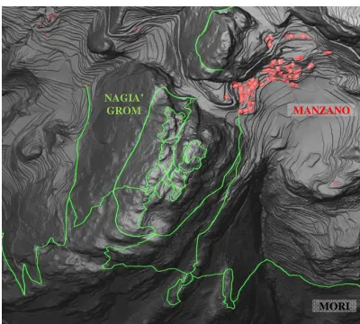
The Gresta Valley is located between the Adige Valley and the Sarca Valley. For this reason the Gresta Valley has always plaid a strategic role in the military strategies for the conquest and control of the surrounding territory. In particular during the World War I, the Gresta Valley was right along the military front from where the Austria-Hungarian Army controlled the crossing over the Loppio Valley, (see Chizzola, 1919; Ceola 1932). For this reason the entire valley was widespread armed with a dense network of entrench paths, tunnels and artillery stations, barracks, depots and cable cars, the most of them was wisely located at the main up-hill sites. The control of the entire area, see Figure 1, was divided between the jurisdiction of the the control of the accesses to the Gresta Valley coming from the Loppio and Vallagarina valleys. The Nangià Grom site, along
with the close monte Faè site, represented the pivot of the defensive line of the monte Biena. The stronghold was designed to be easily defended by encirclements with the higher possible autonomy. A perimetric entrench system was made on the top of the spot to guarantee the defence of the site at 360 degrees, see Figure 2. The summit entrenches, the hypogeum and surface artillery stations and the observation spots was securely connected by a network of trenches to the core services located at the centre of the fortification system, e.g., barracks, depots, water tanks and field kitchen. In the last decade, the most of such artefacts have been discovered and restored by the local association Gruppo Alpini di Mori with the work of several volunteers. Nowadays, the Nagià Grom site is, by their action, a place of memory and meditation and a site exploiting the historical and cultural heritage of that particular landscape.
Figure 1. The study area: Val di Gresta -Italy.
Figure 2. The Nagià Grom site: DTM with entrench paths.
2.2 Survey
Despite the availability of a well established literature on survey and documentation of architectonic artefacts, such as ecclesiastic buildings and more common cultural heritages, entrench and fortification systems are much less commonly object of this kind of studies. Besides that, a considerable effort and an extended on-the-spot investigation have been necessary to design on the field the survey due to the lack of construction plans of the system. The Nagià Grom site is composed by ruins
MANZANO International Archives of the Photogrammetry, Remote Sensing and Spatial Information Sciences, Volume XXXVIII-5/W16, 2011
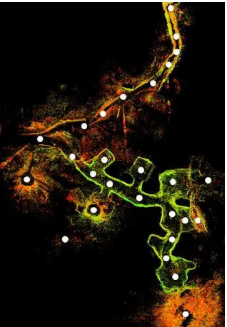
of surface and hypogeum elements, continuous and linked structures beside isolated and independent ones, which together make the survey activity particularly complex and challenging. This motivates the careful selection of those areas and elements demanding greater attention and a better understanding by means of the acquisition of a fine knowledge. In a second step, other minor elements have been integrated with the 3D geometric data, using the GPS survey by the local association Gruppo Alpini di Mori and a new GPS survey of set points for the co-registration of different surveys. The two zones studied in this work are: 1) the kitchen area, including the barrack basement, field stoves and troop shelters; 2) the artillery tunnel and the connected hypogeum depots, workrooms and machine gun positions. The choice to document the Nagià Grom site by means of a terrestrial laser-scanner survey and to use not photogrammetric or image based techniques is due to several aspects: a) the dense vegetation covering the most of the ground surface; b) the complex and articulate structure and organization of the different elements of the site; c) the peculiar geometry of entrenches and tunnels; d) the prohibitive light conditions inside tunnels and hypogeum areas, (Böhler, 2005, Bahmutov et al., 2006). The restoration and exploiting project of the surveyed artefacts is strongly influenced by the choices made when acquiring the geometric data. The survey plan, the locations of the laser-scanner measuring station and the scanning resolution have been set up to facilitate as much as possible the next operations and analyses. A set of 10 scans has been realised to survey the entire kitchen area. The survey of the hypogeum system and of the connected entrench have required a total amount of 27 scans, see Figure 3. All the scans have been performed at the medium resolution of 3x3 cm, probe 5m, given the coarse nature of the surface of the military artefacts and to avoid an unnecessary dense 3D dataset. The kitchen area and the hypogeum system are two distinct and detached objects.
Figure 3. Scheme of laser-scanner scan points set up for the survey of the hypogeum area.
The two independent set of scans have been connected by means of a small local topographic network, see Figure 4. The total station survey has therefore led to an easy and good co-registration of the two scan sets. Eventually, a NRTK-GPS survey has been conducted for georeferencing the co-registered laser-scanner surveys and to permit their integration with the
external airborne laser-scanner DTM, (1x1m res.), published by the Provincia Autonoma di Trento and some next GIS based spatial analysis of the 3D geometric data. In the survey and in the successive analyses of the kitchen area several issues have arisen different from those encountered for entrench and hypogeum systems. The two elements are characterised by different morphologies and the relations between each element and the spatial context are also quite distinct. The kitchen area spreads over more levels and is covered by very dense vegetation hiding the most of the brickwork part of the barracks. Filtering in post-processing the 3D point cloud has been quite demanding for this area, see Figures 5. The survey of the hypogeum system has been made difficult by the presence of rock material on the irregular floor of the tunnel. The most of the rock material found inside the tunnel derives by explosions voluntary operated by the military at the end of the war for the recovering of iron bars and leaving the site unusable. Due the complex and irregular morphology of the interiors of tunnel and entrenches, it has been necessary to set up a large number of close scans to complete the survey of such systems.
Figure 4. Top view of the Nagià Grom site: the scheme of the topographic (blue line) and laser-scanner surveys
(coloured point clouds) on the ALS DTM.
Figure 5. The kitchen area: the original point cloud (top) and the post-processed vegetation free data (bottom).
2.3 Visualisation and Representation of the Fortification System
A classic survey based on the acquisition of a certainly shortage total station measurements, would have lead to a simplified representation of the site where the three-dimensional structure of volumes dug into the rock would not have been described in a proper way. On the contrary, the 3D data acquired with a laser-scanner certainly permit the visualisation of the complex geometry of the particular artefacts of the Nagià Grom site, see Figure 6. Despite the great possibility that laser-scanner borne dataset provide in this respect, the representation of the artefacts of the Nagià Gom site remains challenging and non standard because of the multi-scale complexity of the geometries, see Figures 7-9. Moreover, geometric models permitting a simplified and yet exhaustive representation of such hypogeum artefacts are lacking despite the use of basic geometric shapes, such as triangles in TINs, can be a good starting point. However, once the 3D point cloud has been properly filtered, its visualisation and integration with a DTM have led to inspect the structure and the construction procedure of the site and to better understand the interactions between the landscape, the site and its spatial context.
Figure 6. Simple horizontal and front plans (left) and modern representation based on 3D point cloud visualization
(right) of the same tunnel.
Figure 7. The kitchen area: the post-processed vegetation free data with some CAD drafts, front view (top) and top
view (bottom).
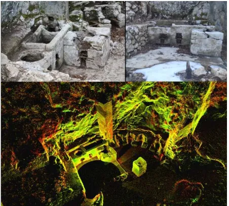
Figure 8. Detail of the field kitchens: present state (top) and visualization of the 3D point cloud (bottom).
3. DATA ANALYSIS
3.1 Landscape-scale
During the World War I, the design and the construction of fortification and entrench systems were tackled with great care and attention by the military. The locations of filed kitchens, observation and artillery points, entrenches and of other artefacts were all chosen in order to respect several requirements. The fortification system, as a whole, was designed as a small village that was easy to defend and, at the same time, ready to support close analogous systems and to control and attack a specific portion of the surrounding territory, see Figure 10.
To better understand the strategic role played by the site during the conflict, the specific design of the Nagià Grom site and its characterisation as a site for the control of the territory, (Leoni et al., 2001), have been analytically investigated using the GIS GRASS (Geographic Resources Analysis System). The georeferenced post-processed 3D point cloud has been integrated with the ALS DTM within the GIS GRASS in order to perform some visibility analysis on some of the most relevant elements of the site, such as the kitchen area and the observation and artillery points, see Figure 11. From the visibility analysis, one can clearly see how the site services, e.g., kitchens, water tanks, current generator, where all located in safe and well protected positions and yet under the direct view and control from the Austria-Hungarian backward stations. On the other hand, the observation and artillery points had a very good visibility of the surrounding territory and were much more exposed to the enemy front and yet well hidden and protected being dug into the rock.
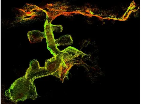
Figure 9. The hypogeum system: visualizations and cross sections of the 3D point cloud.
Figure 10. The location of some strategic elements of the Nagià Grom military site
Figure 11. Visibility map: the portion (in green) of the surrounding territory that can be controlled by one
of the artillery spot (red) of the Nagià Grom site.
3.2 Architectonic-scale
The study conducted at this scale has permitted to understand several aspects of the construction procedure of the Nagià Grom site. From the analysis of technical CAD drawings produced from the filtered 3D point cloud, it has been possible to identify some architectonic features highlighting the typical methodology adopted in the site construction. The building
materials used by the military and their integration were actually innovative for the time. The entrances of tunnel and hypogeum stations were protected by concrete buttress to shield from shrapnel. The architraves, nowadays no longer present, were build with steel beams and were reused by the local population in the post-war reconstruction. The only remain of the barracks is the basement being built of concrete and stones. The military barracks were divided in three rooms, each with a proper function: the water supply area, the Officers' Mess and the kitchens. From on-site inspections and from historical images, a marked modularity of the rooms has been highlighted. The different rooms were built in concrete or in stones and wood, some with and others without roof. The kitchen area, the eight stoves and the big central flue, all built in concrete, are the best preserved artefacts. Until few years ago the area was completely buried and covered by dense vegetation. The kitchens of the Nagià Grom site are the largest found in the Trentino region. The hypogeum system presents a main central way with a rectangular section of about 2.5 by 3 meters and with several adjoining rooms and depots, see Figure 12 (and 13). The floor of the tunnel is tilted and equiped with a small concrete channel for draining rainwater and wastewater. The most of the interior surface of the tunnel was covered by tarred wooden tablets. The places exposed to artillery attacks and to the vibrations caused by the cannon shots, such as the entrance of the tunnel and the inner artillery slots, were instead finished in concrete.
Figure 12. Visualization of the tunnel with the adjoining rooms and entrenches.
3.2.1 Geology and excavation strategy
The analysis of the 3D geometric data of the hypogeum system has shown that the main tunnel has an average slope of about 8 degrees. From on-site inspections and from a careful investigation of the 3D point cloud one can note the clear presence of stratification planes with the same inclination. A first geological analysis, (Tommasello 1972; Avanzini and Caldonazzi, 2006; Avanzini and Zambotto, 2009 ), shows that the Nagià Grom military site is entirely built on a set of limestone layers forming and homogeneous block, see Figure 13. From the geological point of view, the layers are known as “Oolite di Massone limestone” that is a sedimentary rock type with a typical set of (structural) joints that were exploited by the Austria-Hungarian military in the excavation process. The mines were detonated near the joints so the natural collapse of the rock along the stratigraphic splices allowed obtaining roughly planar roof and floor with the observed slight slope, see Figure 14.
Figure 13. Aerial view (top) and scheme of the geological conformation (bottom) of the Gresta Valley.
[Courtesy of M. Avanzini]
Figure 14. Cross sections and pictures of the main tunnel, the structural joints are highlighted in red.
4. CONCLUSIONS AND PERSPECTIVES
A modern and extended survey like the one performed for the documentation of the Nagià Grom site is quite challenging, time and resource demanding, and it cannot be used to define a standard approach for the survey and documentation of any entrench and fortification system in the Trentino region. However, in specific contexts, when sites of high cultural, architectonic and historical values are considered, the integration of GPS, laser-scanner and total station techniques permits an extended and easy way for the acquisition of metric data and the documentation of the sites. Furthermore, the same representation of such sites, by exploiting the dense geometric data acquired, can be very much informative and detailed. The visualisation and analysis of 3D point cloud can then lead to results that can be efficiently archived and made available for public dissemination and further studies. From the TLS survey of the interior of the main tunnel and of the terrain surface above it, a first estimate of the excavation volume and of the rock volume available above the tunnel has been possible. This latter estimate could be useful in a further stability analysis of the hypogeum structures of the Nagià Grom site.
As a future work, the remains of other unknown artefacts could be identified from the analysis of historical images and a new original processing of the raw ALS DSM, (Brovelli et al., 2004; Bretar and Chehata, 2007; Doneus, 2009, Vosselman and Maas, 2010). From the cultural point of view, the development of a restoration project along with a proper public dissemination of the historical heritage of the Nagià Grom site by means of modern web-based virtual reality solutions would also be of great interest, (Guarnieri et al., 2009, Pucci and Marambio, 2009).
5. REFERENCES
Chizzola, O., 1919. La ruina di qua da Trento: Mori nella zona nera. Malfatti, Mori (TN) – Italy.
Ceola, M., 1932. Le difese austriache della zona di Rovereto. Mercurio, Rovereto (TN) – Italy.
Tomasello, M., 1972. Geologia e stratigrafia della zona compresa tra il Monte Brione e la Val di Gresta nel Trentino meridionale. Studi Trentini di Scienze Naturali, 49(1/A):.58-81
Less, A., 1997. Per ricordare S.Barbara 1915-1916. La Grafica, Mori (TN) -Italy.
Fioroni, G., 1988. La Valle di Gresta e la Valle del Cameras nella prima guerra mondiale 1915-1918. Museo Storico della Guerra, Rovereto (TN) – Italy.
Leoni, D., Marchesoni, P., Rastelli, A. (Eds.), 2001. La macchina di sorveglianza: la ricognizione aerofotografica italiana e austriaca sul Trentino: 1915-1918. Museo di Scienze Naturali, Trento & Museo Storico Italiano della Guerra, Rovereto (TN) - Italy.
Riccadonna, D. (Ed.), 2003. Atti del Convegno “Forti Austroungarici nell'Alto Garda: che farne?”, Nago (TN), Italy. Tonelli, Riva del Garda (TN) – Italy.
Brovelli M.A., Cannata M., Longoni U.M., 2004. LIDAR Data Filtering and DTM Interpolation Within GRASS. Transactions in GIS, 8(2): 155-174.
El-Hakim, S.F., Beraldin, J.A., Picard, M., Godin, G., 2004. Detailed 3D Reconstruction of Large-Scale Heritage Sites with Integrated Techniques. ComputerGraphics, 24(3): 21-29.
Less, A., Mederle, O. (Eds), 2004. Ricordi di guerra in Val di Gresta, a Nago e alla Rocchetta: 1915-1918. Biblioteca Comunale di Mori, Mori (TN) – Italy.
Böhler, W., 2005: Comparison of 3D laser scanning and other 3D measurement techniques. In: Recording, Modelling and Visualisation of Cultural Heritage, Taylor&Francis, pp. 89-99.
Avanzini, M., Caldonazzi, M., 2006. Una storia antica: le formazioni rocciose del Trentino, Natura Alpina, 57/1: 3-22.
Bahmutov, G., Popescu, V., Mudure. M., 2006. Efficient Large-Scale Acquisition of Building Interiors. Computer Graphics Forum, 25(3).
Bretar, F., Chehata, N., 2007. Digital Terrain Model on Vegetated Areas: Joint Use of Airborne Lidar Data and Optical Images. International. In: The International Archives of
Photogrammetry, Remote Sensing and Spatial Information Sciences, Munich, Germany, Vol. XXXVI 3/W49A.
Tamburini, A., Tavernini, L., Ischia, M., 2007. La difesa sotterranea: il "Festungabschnitt", settore fortificato di Riva, e le sue opere in caverna nella Grande Guerra. Stella, Rovereto (TN) - Italy.
Avanzini, M.,Zambotto, P., 2008. Geologi in guerra sul fronte trentino. L'Alpe, 19: 29-35.
Grussenmeyer, P., Landes, T., Voegtle, T., Ringle, K., 2008. Comparison Methods of Terrestrial Laser Scanning, Photogrammetry and Tacheometry Data for Recording of Cultural Heritage Buildings. In: The International Archives of Photogrammetry, Remote Sensing and Spatial Information Sciences, Trento, Italy, Vol. XXXVII 5: 213-218.
Grussenmeyer, P., Patias, P., Hanke, K., 2008. Applications in cultural heritage documentation In: Advances in Photogrammetry, Remote Sensing and Spatial Information Sciences. CRC Press, pp. 363–383.
Ikeuchi, K., Miyazaki, D. (Eds), 2008. Digitally Archiving Cultural Objects. Springer.
Doneus, M., Pfennigbauer, M., Studnicka, N., Ullrich, A., 2009. Terrestrial waveform laser scanning for documentation of cultural heritage in woodland. In: Proceedings of the 22nd CIPA-Symposium, Kyoto, Japan.
Guarnieri, A., Pirotti, F., Vettore, A., 2009. An open source application for interactive exploration of cultural heritage 3d models on the web. In: The International Archives of Photogrammetry, Remote Sensing and Spatial Information Sciences, Trento, Italy, Vol. XXXVIII-5/W1.
Pucci, B., Marambio, A., 2009. Olerdola's cave, Catalonia: a virtual reality reconstruction from terrestrial laser scanner and GIS data. In: The International Archives of Photogrammetry, Remote Sensing and Spatial Information Sciences, Trento, Italy, Vol. XXXVIII-5/W1.
Vosselman, G., Maas, H.G. (Eds), 2010. Airborne and Terrestrial Laser Scanning. CRC Press.
6. ACKNOWLEDGEMENT
This work has been carried out in the framework of the project APSAT (Environment and landscapes of Trento district's upland-sites) funded by the Provincia Autonoma di Trento, Italy (Determinazione nr. 22 - 12 giugno 2008).
During the entire curse of the study, the contribution of Dr. Avanzini to the geological analysis has been essential and very much appreciated.