Article
Adaptation to Climate Change through Spatial
Planning in Compact Urban Areas: A Case Study in
the City of Thessaloniki
Athena Yiannakou *,†and Konstantina-Dimitra Salata†
School of Spatial Planning and Development, Aristotle University of Thessaloniki, Thessaloniki 541 24, Greece; [email protected]
* Correspondence: [email protected]; Tel.: +30-231-099-5726 † These authors contributed equally to this work.
Academic Editors: Constantinos Cartalis and Matheos Santamouris
Received: 24 November 2016; Accepted: 7 February 2017; Published: 15 February 2017
Abstract:One of the problems urban areas are facing is the coupled effect of climate change and the Urban Heat Island (UHI) effect. This article attempts to demonstrate the potential of spatial planning to reduce the UHI effect and, hence, to contribute to climate change adaptation in compact urban areas. After a brief review of the relevant literature, the article focuses on one case study within the compact urban area of the city of Thessaloniki. The geographical, socio-economic and urban form data of the study area and its subsequent vulnerability to UHI were initially assessed. Based on these features, a local spatial planning strategy is proposed, and the study proceeds to a detailed amendment of the land use plan, within part of the vulnerable zone. This takes into account the existing urban form, the lack of resources and the availability of the spatial planning tools within the Greek spatial planning system. The main purpose of this article is to highlight the fact that, even in urban areas where the potential for intervention seems to be marginal, because of their existing form, the complexities of the local planning system and resource limitations, improvements to the UHI effect and adaptation to climate change can be achieved by better land use planning and urban design.
Keywords: climate change; urban heat island; spatial planning; green infrastructure; sustainable development; compact urban area; Thessaloniki
1. Introduction
From the end of the 1980s onwards, one of the main issues that has attracted the attention of many researchers from different disciplines is the phenomenon of climate change combined with the Urban Heat Island (UHI) effect [1–3]. This same issue has also attracted the attention of governments, various actors and residents. Despite the existence of many definitions of climate change, an element that all of them have in common is the effect of human intervention on this phenomenon. The interaction between climate change and the urban environment is widely recognized and recorded in various studies [4–13]. Different patterns of settlement, spatial configuration of cities, land use allocation, lifestyle and consumption behaviors, all influence the combined effect of climate change and UHI [2,11,12,14]. All of these factors result in the observed inadvertent climate modification in urban areas [15]. In turn, this combined phenomenon has had significant effects on populations, lifestyle, work, recreation, transport and the built environment [13,16–19]. The complexity, uncertainty and irreversibility demonstrated by this phenomenon are factors that have affected the nature of spatial planning at all levels. This means that climate modification affects what spatial planning does and how it is done [18,20,21]. However, urban areas are considered, concomitantly, to hold the highest potential, both for adaptation to a changing climate and for sustainable development [5,6,22,23].
The immediate need to address the combined effect of climate change and UHI has led to the creation and adoption of mitigation and adaptation policies and actions, which have recently been included on the agenda of policy and planning [24]. Despite the fact that mitigation and adaptation are each considered an integral part of sustainable development, discrepancies between them, particularly in regard to space and time, have been identified [14,25]. Indeed, they may actually conflict [26]. According to Pizarro, 2009 [26], while an urban form may adapt well to climate change in a particular geographical region, the same urban form may also exacerbate climate change. Furthermore, the reverse may be true, meaning that a urban form that is able to mitigate climate change, may not, itself, adapt well to global warming. Thus, even though the compact city is accepted as the most appropriate form for sustainable development and mitigation, this does not mean that it has the resilience to adapt to climate change. In addition, the various spatial planning strategies that are needed for adaptation may not only be inappropriate for mitigation, they may also conflict with each other [12,25]. Hence, it is obvious that there are no “one-size-fits-all” solutions. A more sustainable model of the compact city and an integrated spatial planning approach for adaptation and mitigation are necessary. This would ensure that adaptation policies and measures do not jeopardize mitigation. It would also integrate climate policies into overall sustainable development policies, at all levels of governance [14,27–30].
In this context, spatial planning, and especially land use planning, is emerging as one of the policy areas that can influence adaptation and mitigation to climate change. This, of course, depends on the available resources, tools and types of intervention. It can also provide the strategic framework through which both adaptation and mitigation are placed within the broader perspective of sustainable development [17,20,25,29,31]. This is because spatial planning provides the tools by which climate change policies can be delivered. Through spatial planning, the ways in which cities are designed in order to avoid risks can be revaluated, and the uncertainty and complexity of climate change can be tackled. It is also an essential component of governance and a key determinant of a government’s ability to respond effectively to the impacts of climate change and UHI and to the overall challenge to sustainable development. Thus, spatial planning can contribute both to the design of integrated approaches to adaptation and mitigation and to the integration and coordination of related policies and investments for a more sustainable development. Through this process, seemingly conflicting interests can be mediated. For example, trade-offs between economic, social and environmental objectives can be negotiated, and a long-term perspective on spatial development can be adopted. Moreover, since spatial planning affects the distribution and the spatial dimension of the activities and investments of current and future generations, intra- and inter-generational equity concerns can be considered. The potential of planning to facilitate behavioral change, to act independently of administrative boundaries and the scale of governance, to promote participation and to help to generate and disseminate knowledge and best practices, all contribute to the sustainability and resilience of urban areas [16–18,20,24,29,32,33]. As land values are determined by land uses and climate change is becoming a concern for the insurance industry, this is becoming an additional crucial factor that makes planning essential for mitigation [16]. Finally, the importance of the role of spatial planning in tackling climate change is highlighted by the fact that both vulnerability to climate change and adaptation/mitigation measures exhibit spatial characteristics [2,29,34].
Therefore, the factors determining an urban area’s potential for sustainable development and resilience promotion coincide with the factors influencing its capacity to adapt to climate change [4,35]. However, due to the fact that the role of spatial planning is often undermined, there is a possibility that the economic recession will shift the focus of spatial planning priorities away from social and environmental goals and towards economic development. If this were to transpire, then planning’s sustainability objectives would be considered a luxury rather than a necessity [20]. At the same time, resource constraints imposed by the economic crisis may limit planning activities related to climate change [25].
a multifunctional network of environmental and other assets. These assets are public and private, existing and new and cover all spatial scales. The design and management of this network both contributes to the sustainability of communities and enhances the local character of urban areas [26]. Assets forming that network could be street trees, green roofs and walls, private gardens, pedestrian and cycle routes, road and railway networks, pocket parks, city parks, regional or national parks, churchyards, school grounds, institutional open spaces, play areas, local nature reserves, sports pitches, allotments, vacant and derelict land, brownfield land, agricultural land, ponds/lakes, rivers and floodplains and urban-municipal plazas [3,36,37].
In the light of the above, the main aim of this paper is to demonstrate practically how a compact urban area can adapt to the coupled phenomena of climate change and UHI by better land use planning and urban design. Furthermore, it aims to demonstrate that this can happen even where the potential for intervention seems to be marginal due to its form, the complexities of the planning system and resource limitations. In order to achieve this aim, a case study in the Municipality of Kalamaria, in the compact part of the city of Thessaloniki, was chosen. After an analysis of the study area, which revealed the vulnerability of the municipality to climate change and UHI, a detailed revision of the statutory land use plan was formulated. The outcome proves that improvements to the UHI effect, and adaptation to climate change can be achieved in a compact built-up environment, through better urban planning and design.
2. Data Analysis and Methods for the Definition of the Vulnerability of the Study Area
Vulnerability to the UHI effect is determined by a combination of factors, such as higher temperatures and climatological trends, demographic factors, quality of life and other socio-economic components, as well as by urban design characteristics [2,3,11,38–47]. Therefore, data from the study area were classified according to three sets: climatic conditions/environmental data, including temperature, humidity, wind, rising sea levels, air pollutants; demographic data, including population change, demographic and socio-economic structure; and urban form data, including layout plan, building characteristics, land uses, densities, open spaces/Green Infrastructure.
2.1. Climatic Conditions/Environmental Data and Demographic Data
The Municipality of Kalamaria is situated on the southeast coastal area of the compact part of the city of Thessaloniki. It has an extensive sea front, with a total coastline of about 5.5 km, and an open, flood-protection, trench passage, Eastern Peripheral Trench (PT), in its northern part. The climate in Thessaloniki is Mediterranean, with cold and wet winters and hot and dry summers. Based on available data from the Hellenic National Meteorological Service [48], Thessaloniki also exhibits high humidity levels, which have increased in recent years. Moreover, since 1951, the temperature in the city has been increasing. The average annual temperature increased by more than 1◦C in the period 1958–1999 [48], and this trend is expected to continue. This consequence of climate change, along with the expected increase in extreme climatic events, such as heat waves, is likely to increase UHI intensity [12,13]. Studies have shown that Thessaloniki has become more arid and that, while the annual rainfall levels are significantly lower, rainfall itself has become heavier [49], which means an increased risk of flash floods. The average annual wind speed is relatively weak, reaching 5.5 Kt (knots), and its direction is northwest. Regarding the data on air pollution, the concentration values for nitrogen dioxide (NO2) and Particulate Matter (PM10) in the municipally exceed the baseline. This can
be attributed to the increased traffic and central heating systems in houses. Finally, on Thessaloniki’s coast line, the sea level is rising at a higher level, 4.0 mm/year, than the global average of 1–2 mm/year. These facts indicate that the UHI effect and the rise of the sea level are two of the most crucial problems with which the Municipality of Kalamaria has to deal.
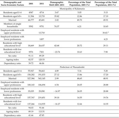
on resources (land, energy and water), a greater need for travel, higher population densities, etc. All of these features could have resulted in the observed intensity of UHI and climate change. Given that the felt effects of climate change depend on gender, age, education and social class [2,11,12,38–41,44–47], the Municipality of Kalamaria has a high degree of so-called “generic vulnerability” (Table1). This is due to the fact that it features an increased percentage of elderly (over the age of 65), higher than the average in the Prefecture of Thessaloniki. More remarkable is the fact that over a 10-year period (2001–2011), the percentage of the elderly increased by 36% and by 27% in the Prefecture of Thessaloniki. This trend has been intensified in the current decade due to out-migration of younger people as a consequence of the economic crisis. The municipality featured a small increase in the population of small children (0–4 years old) in the period 2001–2011. Both of these groups are considered to be particularly exposed and sensitive to the impacts of climate change and find it harder to adapt [2,12,41,43–47,51–53]. The composition of population by sex was not examined as a variable, since the relevant studies report conflicting evidence [40,45,47]. Social isolation is another important factor determining vulnerability [41,44,45]. Even though the percentage of people living alone is low, it had a notable increase in the period of 2001–2011. Households with more than one person are considered to be less affected by heat stress, as they can seek and receive care when needed [41].
Table 1.Demographic and socio-economic factors of generic vulnerability.
Demographic and
Residents aged 0–4 4547 4714 3.67 5.05 5.15 Residents aged 65+ 11,584 15,733 35.82 12.86 17.19 Married 44,777 45,681 2.02 49.70 49.91
educational level 18,669 26,637 42.68 20.72 29.11 Residents with low
educational level 9576 7301 −23.76 10.63 7.98
Sex ratio 91.11 89.29 Ageing index 82.57 120.53 Dependency ratio 39.72 46.06
Prefecture of Thessaloniki
Residents aged 0–4 55,927 58,663 4.89 5.16 5.28 Residents aged 65+ 150,282 191,033 27.12 13.86 17.20 Married 527,384 543,145 2.99 48,65 48.91 Employed residents with
upper professions 100,143 106,694 6.54 24.05 28.88 Employed residents with
lower professions 35,035 29,090 −16.97 24.05 28.88
Residents with high
educational level 157,767 219,451 39.10 14.55 19.76 Residents with low
educational level 137,266 114,935 −16.27 12.66 10.35
Sex ratio 94.03 91.66 Ageing index 89.19 113.51 Dependency ratio 41.66 47.85
1The percentage of residents with upper and lower professions for both the municipality and the prefecture, for 2001
Regarding employment data, 15% of the employed population accounts for upper professions, while unskilled laborers account for just 1.6%. This socio-economic configuration represents a middle-class area, in contrast to the social structure of the Prefecture of Thessaloniki (Table1). The demographic composition indicates that, on the one hand, the residents may have less environmentally-friendly lifestyles (high car ownership and use, high energy consumption, etc.), but, on the other hand, that they are more likely than people with lower incomes to adapt to new and more efficient technologies [16]. The higher educational level of the residents could also lead them to be more able to understand the impacts of climate change and therefore more open to new alternatives. This in turn could result in them being more willing to participate in both collective action and the decision-making process, thereby helping them to adapt more easily and efficiently. It is worth noting that the Municipality of Kalamaria exhibits a higher percentage of residents occupied in upper professions compared to that of the Prefecture of Thessaloniki. However, both the municipality and the prefecture exhibit high unemployment rates, which has increased dramatically after 2009 due to the economic crisis. Unemployment indicates a sensitivity of the population; it can be associated with social isolation, low income and poor living conditions, thus leading to vulnerability [41,44,46].
2.2. Urban Form Data
There are also physical environment factors that determine generic vulnerability, which relate to the urban form and urban fabric. Building obsolescence has been recognized as a vulnerability factor, since it can result in increased heat exposure of the residents. This is due to the fact that old buildings lack insulation and rely on natural ventilation (open windows and doors during hot weather) [41,44,45]. As shown in Table2, only a small percentage of the residences in the municipality can be classified as old (built before 1970), while 27.2% of the residences do not have any form of insulation. Moreover, the building stock of the municipality is in better condition than that of the prefecture. Small living places can also influence vulnerability [41,46,47]. The proportion of residences with only one room and with a living area per person less than 15 m2is low, an indicator that may
reflect the higher socio-economic status of the municipality’s households. However, it is worth noting that, during 2001–2011, the percentage of residences with one room increased remarkably, both in the Municipality of Kalamaria and in the Prefecture of Thessaloniki.
Table 2.Urban form factors of generic vulnerability.
Urban Form Factors 2001 2011 Shift 2001–2011Demographic the Total, 2001Percentage of the Total, 2011Percentage of
Municipality of Kalamaria
Residences built before 1970 5886 13.01 Residences without insulation 45,233 27.19 Residences with only one room 445 2157 348.72 1.16 4.77
Dwelling density
(under 15 m2per inhabitant) 722 1.96
Prefecture of Thessaloniki
Residences built before 1970 130,660 158,947 21.65 36.82 27.04 Residences without insulation 587,927 33.34 Residences with only one room 7628 34,680 354,64 1.55 5.90
Dwelling density
(under 15 m2per inhabitant) 15,530 3.62
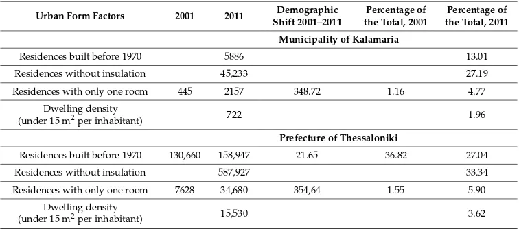
Figure 1. Urban heat island intensity in specific roads within the municipality. ∆Tu-r(max): urban Figure 1.Urban heat island intensity in specific roads within the municipality.∆Tu-r(max): urban heat island intensity.
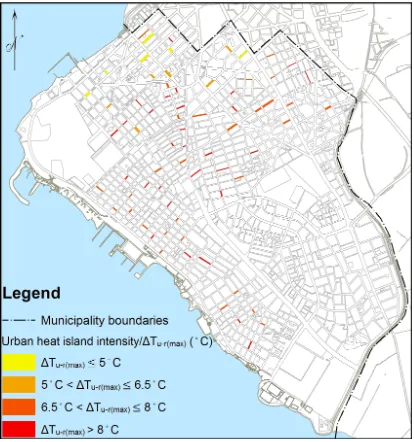
Figure 2. Population density and parallel to the sea routes. Inh: inhabitants. Figure 2.Population density and parallel to the sea routes. Inh: inhabitants.
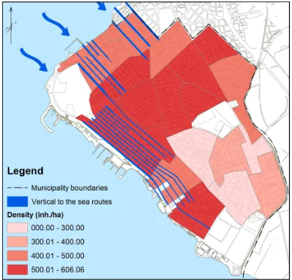
Figure 3. Commercial and recreational land uses in conjunction with traffic volumes. Figure 3.Commercial and recreational land uses in conjunction with traffic volumes.
is the main flood protection and drainage collector of Eastern Thessaloniki. This area functions as a natural ecosystem, on the edge of the compact part of the city, forming a long green corridor, and connecting natural elements (mountain, sea, streams) within the city of Thessaloniki. Furthermore, existing pedestrian routes are not linked to form a complete network, while the entire municipality, also, lacks a network of bicycle lanes and green roofs and/or facades. As a result, an absence of a network of open, green spaces and their interconnection with blue infrastructure can be observed. This absence can cause problems, such as an intensification of the UHI effect and localized flooding from overburdened drains and intensive precipitation.
However, field recordings demonstrated a satisfactory number of private GI assets. The municipality has several private gardens, small private open spaces between the buildings and rather rich greenery, with many trees on the sidewalks and flower beds on the pavement. Interestingly, the various green niches within the network of streets occupy a larger area than those of small parks. This fact emphasizes the importance that should be given to their management, aiming at facilitating natural ventilation and reducing air pollution and urban noise. The uncovered parts of many blocks are airy and/or consolidated and can be accessed from the street. This offers the potential to create green corridors, in combination with unstructured or derelict land and private parks. These private green spaces could contribute to improving the quality of the urban environment, providing shade and cooling, as well as allowing ventilation. In this way, these spaces could enhance the possibility of adapting to climate change. Another important GI asset is the physical configuration of the municipality’s sea front, which could help with ventilation and lessen the impact of rising sea levels.
2.3. Defining the Vulnerability of the Study Area
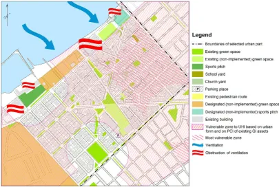
An examination of the combined effects of factors from the three datasets above allows us to identify a zone that is potentially more vulnerable to the coupled effect of climate change and UHI. This was achieved with a Geographic Information System (GIS) overlay analysis. Essentially, by mapping and then overlaying the layout pattern and urban form, we were able to identify a first zone that was prone to the increase of temperature (Zone 1, Figure4). This mapping allowed us to examine the possible cooling effect provided by the wind through the roads parallel to the sea, by the density of urban units, by the commercial and recreational land use and by the traffic volumes.
Figure 4. Vulnerable area in the municipality (modified from Salata and Yiannakou, 2016 [54]). PCI, Figure 4.Vulnerable area in the municipality (modified from Salata and Yiannakou, 2016 [54]). PCI, Park Cool Island; GI, Green Infrastructure.
3. Spatial Planning Adaptation Strategy
It is a common argument that any effective planning regarding a city’s adaptation to climate change should be based on an integrated strategy. This strategy should not only increase the effectiveness of separate, piecemeal actions and their multiplier effects, but it should also increase the city’s resilience. Such a strategy should function as a field for the coordination of different interests and various actors, whose actions affect the forms of development in a specific area. For this reason, before proceeding to redesigning the statutory land use and layout plan, an overall adaptation strategy is proposed.
3.1. An Overall Adaptation Strategy
Sustainable urban management: Any strategy for sustainable urban development, including adaptation to climate change, presupposes the involvement of stakeholders in the decision-making process. It presupposes them being informed and educated about the adaptation policies and measures (through workshops, communication platforms, encouragement of community-based organizations, etc.). Such a strategy could generate new behaviors and new social norms, increasing awareness and facilitating the building of the community’s potential. The promotion of collaboration between the local authority and the citizens, as well as their cooperation with higher tiers of decision-making are essential.
Sustainable urban design: Both the preservation and protection of existing GI assets along with the implementation of the designated ones are of great importance. In conjunction, the prevention of further reconstruction on the sea front and the relocation of some built-up uses away from the sea front to other locations are essential. At the same time, the formation of a GI is a matter of necessity. This would consist of a network of assets that would connect green areas, other open public and private spaces within the building complexes, the coastal front, the large unused barracks, the city’s forest area through the Peripheral Trench and other assets. The formation of these green corridors would help the movement of air masses within the compact urban area, enabling cooling and ventilation. These green corridors would also help in tackling the UHI effect and urban canyons, along with facilitating the reduction of air pollution. Other benefits would be the protection against floods, coastal storms and the expected rise in sea level. This is due to the fact that GI can absorb a great deal of rainwater, leading to a reduction of the burden on the city’s sewage system and to increased biodiversity conservation. GI could also contribute significantly to the reduction of greenhouse gas (GHG) emissions and, so, to climate change mitigation, since GI assets can function as carbon sinks. In order to enhance GI assets, existing green corners that are formed along the roads could be widened, and new ones could be created, while planting of sidewalks should be encouraged. All of these should be implemented with a great deal of caution and proper planning because, as Oke (1989) [10] points out, the solution to one problem may be the cause of another. For example, street trees may hinder air flow and, thus, result in poor air quality.
Sustainable transport: One of the major advantages of a compact city with mixed uses, such as the one in our case study, is the short distances between the various functions and uses. Thus, priority could be given both to public and to alternative and more sustainable means of transport, such as cycling and pedestrian routes, which could be part of the GI. These measures would, in turn, contribute to tackling air pollution. Other measures that could easily be adopted in compact areas, in order to discourage the use of private cars, are speed limits, traffic calming measures and eco-driving.
Sustainable design and construction: Bioclimatic design and construction for each new building should be encouraged, including the planning of its location and orientation, in order to maximize the benefits of local conditions, such as natural ventilation and lighting. According to Greek law (Act 4067/2012), 2/3 of the non-built-up area within a building block should be planted, while enabling its integration into a network of free, public and accessible open spaces, solely for pedestrians. It is proposed that the remaining portion of the non-built-up area in this building block should be covered with “cool” materials. Green roofs and facades can also save energy by aiding heating and cooling, to absorb airborne pollutants and dust and to improve microclimate and ventilation of the urban area. Moreover, their integration into the proposed green corridor could encourage the creation of small ecosystems within the private building blocks.
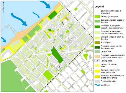
3.2. Redesigning the Land Use and Layout Plan of the Vulnerable Area
above (Figure4). Secondly, within this zone, fieldwork was conducted in order to document all of the GI assets in detail, along with the existence of non-built-up sites and their detailed uses, as well as documenting the characteristics of the road network and traffic conditions. Then, an evaluation of the availability of open green spaces, of the problems with poor ventilation, of traffic problems and of the degree of risk from rising sea levels was performed. Based on this evaluation, an urban area was defined. A second evaluation of the area was made, regarding the opportunities for adapting to climate change and UHI. On this basis, a detailed new design was produced according to the overall adaptation strategy displayed above. This new design essentially revises the existing authorized layout plan. One important consideration was that all changes suggested in the new design should be applicable within the existing provisions of the Greek planning system.
Figures5and6illustrate the selected part of the vulnerable zone, which is located near the coast. One of the main goals of the new design is the creation of a linear, continuous green corridor along the coast line. Within this corridor, natural and green spaces will be protected, and under some circumstances, the existing land uses of sport and tourism-recreation could continue to be accommodated. In this way, it would be possible to protect against the expected rise in sea level due to climate change and to ensure the unimpeded flow of air into the urban area, which would reinforce urban cooling. As a result, the adaptive capacity of the municipality would increase. Therefore, one of the proposals is the creation of a coastal protected zone, in order to prevent any further construction on the coastal front and to reinforce land uses only for green space and sports. The existing green and open spaces should be remodeled and designed according to bioclimatic principles. In the longer run, it is advisable for any vulnerable uses, such as the school buildings, to be transferred to appropriate publicly-owned sites within the residential area. At the same time, the existing site could be turned into a green space. For the time being, other structures designated as “protected” buildings, such as the yacht club and one house building, do not obstruct the air flow, due to their low height. The same applies to the school building. As for the only privately-owned block built on the coastal front, it is proposed that the small vacant buildings should be demolished while preserving the existing uncovered parts between the buildings, so that air corridors could be formed.
In the remaining area of the selected urban part, the preservation of existing GI assets and the creation of new ones is essential. This process should take place alongside the integration of these assets into a coherent network. The bioclimatic design of these spaces should be encouraged. Additionally, certain small buildings could be demolished or relocated within the existing site, to encourage the free flow of air. Special consideration has been given to the uncovered parts of blocks, which have been redesigned as obligatory private green space, to create corridors for easing the air flow (Figure6). Urban design measures, such as the use of heat-absorbent construction materials and structures and the increase of the albedo of buildings and pavements, can contribute to reduce the local temperature [2,43].
Figure 6. Proposed revision of the layout plan of the selected section.
Figure 6.Proposed revision of the layout plan of the selected section.
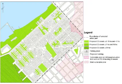
Figure 7. Reduction of the vulnerable zones. Figure 7.Reduction of the vulnerable zones.
Another point worth mentioning is the fact that the implementation of this new design in the selected part may result in an almost 16% reduction of the total vulnerable zone in the municipality (i.e., the vulnerable zone based on the urban form, as well as the PCI of the existing GI assets). It may also result in a 7% reduction of the most vulnerable zone of the municipality. These figures demonstrate that the redesign of even a small part of the urban area can make a significant contribution to the tackling of the combined effect of climate change and UHI. However, it should be stressed that the above-mentioned cooling effects and the figures regarding the reduction of the vulnerable zones are indicative. This is because established standards do not exist, and the PCI of every GI should be determined by separate in situ measurement and fieldwork.
4. Discussion and Conclusions
The relationship between urban form and the combined effect of climate change and UHI is still an open question, in the relevant literature, as well as in spatial planning practice. Compact cities are commonly accepted as a sustainable form of urban development, as this form allows for a wider sustainable development strategy to be applied (less pressure on natural resources, shorter distances and less journeys, easier use of slow and public modes of transport, etc.). However, compact cities face a number of acute problems, such as high levels of traffic, congestion, lack of open spaces and decaying building stock. These are all issues related to climate change and UHI. As we usually encounter this particular urban form in the older parts of larger metropolitan areas, planning and redesigning them is a very difficult task. The present paper attempted to show that, despite the serious problems of a compact city, such as those existing in many Greek cities, and despite the inadequacies in the availability of effective planning tools, there is still room to improve the local urban form and environment. These improvements would enable local authorities to cope with the impacts of a changing climate and, eventually, to improve the local quality of life.
illustrates that at the same time, it offers opportunities for adaptation. First of all, the inadequacy of the fragmented, small-sized urban GI assets, in the tackling of climate change and UHI, is pointed out, along with the necessity of an integrated network of GI assets. Another key finding is that the proposed planning and design strategy does not require major changes or modifications of the existing statutory plan. This means that if the planning system in Greece were to become a little more flexible, the implementation of adaptation policies would be feasible. This rationale supports the view that climate change can reshape spatial planning. Moreover, the proposed adaptation measures do not jeopardize mitigation; on the contrary, they develop synergies between them.
Special emphasis should be given to the participation of residents and other actors in the planning process, as well as to their contribution through volunteer work and funding. This is crucial, given the current economic recession and the limitation of resources. Moreover, the implementation of a strategy, such as the one proposed, would help with city marketing and branding, which in turn would boost the local economy. What is worth mentioning is that GI can both encourage voluntary actions and deliver economic benefits, along with the environmental and social ones [36]. Therefore, based on the above-mentioned findings, we can state that an adaptation strategy based on GI could contribute to both the sustainable development and the resilience of compact urban areas.
Finally, the lack of sufficient data, regarding the relationships between the compact city, climate change and UHI, should be highlighted. Reliable data and verifiable measurements of urban structure, atmospheric pollution and climate-meteorological data, as well as detailed and accurate mapping of existing GI assets (especially private gardens and uncovered parts of blocks) are generally inadequate in Greece. This situation poses a serious challenge for spatial planning, as problems presented by climate change and UHI cannot be identified, and so, appropriate policies cannot be formulated. Our spatial planning system should therefore take up the challenge and structure a comprehensive national framework for addressing climate change. This could be achieved by integrating previous knowledge and good practices that have been acquired, in relation to urban areas, climate change and UHI. Thus, future research in Greece should focus on the acquisition of the relevant data, the quantification of the results of strategies, such as the one proposed, and on the content of beneficial revisions and amendments to existing spatial plans.
Author Contributions:The two authors contributed substantially and equally to the research and writing of the presented paper. Both authors read and approved the final manuscript.
Conflicts of Interest:The authors declare no conflict of interest.
References
1. Davoudi, S. Introduction to Part 1. InPlanning for Climate Change: Strategies for Mitigation and Adaptation for Spatial Planners; Davoudi, S., Crawford, J., Mehmood, A., Eds.; Earthscan: London, UK, 2009; pp. 3–5. 2. Van der Hoeven, F.; Wandl, A. Amsterwarm: Mapping the landuse, health and energy-efficiency implications
of the Amsterdam urban heat island.Build. Serv. Eng. Res. Technol.2015,36, 67–88. [CrossRef]
3. Norton, B.A.; Coutts, A.M.; Livesley, S.J.; Harris, R.J.; Hunter, A.M.; Williams, N.S. Planning for cooler cities: A framework to prioritise green infrastructure to mitigate high temperatures in urban landscapes. Landsc. Urban Plan.2015,134, 127–138. [CrossRef]
4. Bulkeley, H.; Betsill, M.Cities and Climate Change: Urban Sustainability and Global Environmental Governance; Routledge: London, UK, 2003.
5. Organisation for Economic Co-operation and Development (OECD). Competitive Cities and Climate Change. In Proceedings of the OECD International Conference on “Competitive Cities and Climate Change”, Milan, Italy, 9–10 October 2008; Available online: https://www1.oecd.org/gov/regional-policy/50594939.pdf (accessed on 26 December 2014).
7. Kern, K. Climate Governance in the EU Multi-Level System: The Role of Cities. In Paper Presented in Fifth Pan-European Conference on EU Politics, Porto, Portugal, June 2010; Available online: http://www.jhubc. it/ecpr-porto/virtualpaperroom/147.pdf (accessed on 15 January 2012).
8. World Bank. Cities and Climate Change: An Urgent Agenda, 1st ed.; The World Bank: Washington, DC, USA, 2010; Available online: https://openknowledge.worldbank.org/handle/10986/17381 (accessed on 10 August 2011).
9. United Nations Human Settlements Programme (UN-HABITAT).Cities and Climate Change: Global Report on Human Settlements 2011. United Nations Human Settlements Programme; Earthscan: London, UK; Washington, DC, USA, 2011; Available online: http://unhabitat.org/books/cities-and-climate-change-global-report-on-human-settlements-2011/ (accessed on 7 January 2016).
10. Bulkeley, H.Cities and Climate Change; Routledge: London, UK, 2013.
11. Kim, S.; Ryu, Y. Describing the spatial patterns of heat vulnerability from urban design perspectives.Int. J. Sustain. Dev. World Ecol.2015,22, 189–200. [CrossRef]
12. Dugord, P.A.; Lauf, S.; Schuster, C.; Kleinschmit, B. Land use patterns, temperature distribution, and potential heat stress risk-the case study Berlin, Germany.Comput. Environ. Urban Syst.2014,48, 86–98. [CrossRef] 13. Gill, S.E.; Handley, J.F.; Ennos, A.R.; Pauleit, S. Adapting Cities for Climate Change: The Role of the Green
Infrastructure.Built Environ.2007,33, 115–133. [CrossRef]
14. Davoudi, S.; Crawford, J.; Mehmood, A. (Eds.) Planning for Climate Change: Strategies for Mitigation and Adaptation for Spatial Planners; Earthscan: London, UK, 2009.
15. Oke, T.R.Boundary Layer Climates, 2nd ed.; Methuen: London, UK, 1987.
16. Blakely, E.J.Urban Planning for Climate Change; Working Paper; Lincoln Institute of Land Policy, 2007; Available online: http://masgc.org/climate/cop/Documents/UP.pdf (accessed on 9 April 2011).
17. Davoudi, S. Framing the Role of Spatial Planning in Climate Change. 2009. Available online: http://www. ncl.ac.uk/guru/publications/working/documents/EWP43.pdf (accessed on 9 August 2011).
18. Van Buuren, A.; Driessen, P.P.J.; van Rijswick, M.; Rietveld, P.; Salet, W.; Spit, T.; Teisman, G. Towards Adaptive Spatial Planning for Climate Change: Balancing Between Robustness and Flexibility. J. Eur. Environ. Plan. Law2013,10, 29–53. [CrossRef]
19. Santamouris, M. Heat island research in Europe: the state of the art.Adv. Build. Energy Res.2007,1, 123–150. [CrossRef]
20. Davoudi, S.; Crawford, J.; Mehmood, A. Climate Change and Spatial Planning Responses. InPlanning for Climate Change: Strategies for Mitigation and Adaptation for Spatial Planners; Davoudi, S., Crawford, J., Mehmood, A., Eds.; Earthscan: London, UK, 2009; pp. 7–18.
21. Bulkeley, H. Planning and Governance of Climate Change. InPlanning for Climate Change: Strategies for Mitigation and Adaptation for Spatial Planners; Davoudi, S., Crawford, J., Mehmood, A., Eds.; Earthscan: London, UK, 2009; pp. 284–296.
22. Roth, M. Effects of Cities on Local Climates. In Proceedings of the Workshop of IGES/APN Mega-City Project, Kitakyushu, Japan, 23–25 January 2002; Available online: http://pub.iges.or.jp/contents/13/data/ PDF/08-1(Roth).pdf (accessed on 8 July 2014).
23. Bai, X.; McAllister, R.R.J.; Beaty, R.M.; Taylor, B. Urban policy and governance in a global environment: Complex systems, scale mismatches and public participation.Curr. Opin. Environ. Sustain.2010,2, 129–135. [CrossRef]
24. Howard, J. Climate Change Mitigation and Adaptation in Developed Nations: A Critical Perspective on the Adaptation Turn in Urban Climate Planning. InPlanning for Climate Change: Strategies for Mitigation and Adaptation for Spatial Planners; Davoudi, S., Crawford, J., Mehmood, A., Eds.; Earthscan: London, UK, 2009; pp. 19–32.
25. Cashmore, M.; Wejs, A. Constructing Legitimacy for Climate Change Planning: A Study of Local Government in Denmark.Glob. Environ. Chang.2014,24, 209–212. [CrossRef]
26. Pizzaro, R. Urban Form and Climate Change: Towards Appropriate Development Patterns to Mitigate and Adapt to Global Warming. InPlanning for Climate Change: Strategies for Mitigation and Adaptation for Spatial Planners; Davoudi, S., Crawford, J., Mehmood, A., Eds.; Earthscan: London, UK, 2009; pp. 33–45.
28. Grimm, N.B.; Faeth, S.H.; Golubiewski, N.E.; Redman, C.L.; Jianguo, W.; Xuemei, B.; Briggs, J.M. Global Change and the Ecology of Cities.Science2008,319, 756–760. [CrossRef] [PubMed]
29. Biesbroek, G.R.; Swart, R.J.; van der Knaap, W.G.M. The mitigation-adaptation dichotomy and the role of spatial planning.Habitat Int.2009,33, 230–237. [CrossRef]
30. Depietri, Y.; Welle, T.; Renaud, F.G. Social vulnerability assessment of the Cologne urban area (Germany) to heat waves: Links to ecosystem services.Int. J. Disaster Risk Reduct.2013,6, 98–117. [CrossRef]
31. Measham, T.G.; Preston, B.L.; Smith, T.F.; Brook, C.; Gorddard, R.; Withycombe, G.; Morrison, C. Adapting to climate change through local municipal planning: Barriers and challenges.Mitig. Adapt. Strateg. Glob. Chang. 2011,16, 889–909. [CrossRef]
32. Banister, D.; Anable, J. Transport Policies and Climate Change. InPlanning for Climate Change: Strategies for Mitigation and Adaptation for Spatial Planners; Davoudi, S., Crawford, J., Mehmood, A., Eds.; Earthscan: London, UK, 2009; pp. 55–68.
33. Hurlimann, A.C.; March, A.P. The role of spatial planning in adapting to climate change.WIREs Clim. Chang. 2012,3, 477–488. [CrossRef]
34. Davidse, B.J.; Othengrafen, M.; Deppisch, S. Spatial planning practices of adapting to climate change.Eur. J. Spat. Dev.2015,57. Available online: http://www.nordregio.se/Global/EJSD/Refereedarticles/refereed57. pdf (accessed on 28 May 2015).
35. Intergovernmental Panel on Climate Change (IPCC). Climate Change 2007: Working Group II: Impacts, Adaptation and Vulnerability. Available online: http://www.ipcc-wg2.gov/AR4/website/20.pdf (accessed on 28 September 2011).
36. Natural England. Green Infrastructure Guidance (NE176). 2009. Available online: http://publications. naturalengland.org.uk/publication/35033?category=49002 (accessed on 17 July 2014).
37. Landscape Institute. Green Infrastructure: Connected and Multifunctional Landscape-Position Document; Landscape Institute: London, UK, 2009; Available online: http://www.landscapeinstitute.org/PDF/ Contribute/GreenInfrastructurepositionstatement13May09.pdf (accessed on 2 August 2014).
38. Uejio, C.K.; Wilhelmi, O.V.; Golden, J.S.; Mills, D.M.; Gulino, S.P.; Samenow, J.P. Intra-urban societal vulnerability to extreme heat: The role of heat exposure and the built environment, socioeconomics, and neighborhood stability.Health Place2011,17, 498–507. [CrossRef] [PubMed]
39. Aubrecht, C.; Özceylan, D. Identification of heat risk patterns in the US National Capital Region by integrating heat stress and related vulnerability.Environ. Int.2013,56, 65–77. [CrossRef] [PubMed] 40. IPCC. Managing the Risks of Extreme Events and Disasters to Advance Climate Change Adaptation.
InA Special Report of Working Groups I and II of the Intergovernmental Panel on Climate Change; Field, C.B., Barros, V., Stocker, T.F., Qin, D., Dokken, D.J., Ebi, K.L., Mastrandrea, M.D., Mach, K.J., Plattner, G.K., Allen, S.K., et al., Eds.; Cambridge University Press: Cambridge, UK; New York, NY, USA, 2012.
41. Buscail, C.; Upegui, E.; Viel, J.F. Mapping heatwave health risk at the community level for public health action.Int. J. Health Geogr.2012,11, 38. [CrossRef] [PubMed]
42. Keramitsoglou, I.; Kiranoudis, C.T.; Maiheu, B.; De Ridder, K.; Daglis, I.A.; Manunta, P.; Paganini, M. Heat wave hazard classification and risk assessment using artificial intelligence fuzzy logic. Environ. Monit. Assess.2013,185, 8239–8258. [CrossRef] [PubMed]
43. Díaz, J.; Carmona, R.; Mirón, I.J.; Ortiz, C.; León, I.; Linares, C. Geographical variation in relative risks associated with heat: Update of Spain’s heat wave prevention plan.Environ. Int.2015,85, 273–283. [CrossRef] [PubMed]
44. Ho, H.C.; Knudby, A.; Huang, W. A Spatial Framework to Map Heat Health Risks at Multiple Scales.Int. J. Environ. Res. Public Health2015,12, 16110–16123. [CrossRef] [PubMed]
45. Aminipouri, M.; Knudby, A.; Ho, H.C. Using multiple disparate data sources to map heat vulnerability: Vancouver case study.Can. Geogr.2016,60, 356–368. [CrossRef]
46. Zhu, Q.; Liu, T.; Lin, H.; Xiao, J.; Luo, Y.; Zeng, W.; Zeng, S.; Wei, Y.; Chu, C.; Baum, S.; et al. The spatial distribution of health vulnerability to heat waves in Guangdong Province, China.Glob. Health Action2014, 7. Available online: http://www.globalhealthaction.net/index.php/gha/article/view/25051 (accessed on 30 December 2016).
48. Hellenic National Meteorological Service. Available online: http://www.hnms.gr/hnms/greek/ climatology/climatology_region_diagrams_html?dr_city=Thessaloniki_Mikra (accessed on 7 May 2012). 49. YPEHODE.Third National Report of the UN Framework-Convention on Climate Change; YPEHODE: Athens,
Greece, 2002.
50. Hellenic Statistical Authority. Available online: http://www.statistics.gr/en/statistics/pop (accessed on 12 June 2016).
51. Oven, K.J.; Curtis, S.E.; Reaney, S.; Riva, M.; Stewart, M.G.; Ohlemüller, R.; Dunn, C.E.; Nodwell, S.; Dominelli, L.; Holden, R. Climate change and health and social care: Defining future hazard, vulnerability and risk for infrastructure systems supporting older people’s health care in England.Appl. Geogr.2012,33, 16–24. [CrossRef]
52. European Environment Agency (EEA). Urban Adaptation to Climate Change in Europe: Challenges and Opportunities for Cities Together with Supportive National and European Policies; EEA Report No. 2/2012; Office for Official Publications of the European Union: Luxembourg, 2012; Available online: http://www.eea. europa.eu/highlights/publications/urban-adaptation-to-climate-change (accessed on 8 September 2012). 53. Laverdière, É.; Payette, H.; Gaudreau, P.; Morais, J.A.; Shatenstein, B.; Généreux, M. Risk and protective
factors for heat-related events among older adults of Southern Quebec (Canada): The NuAge study.Can. J. Public Health2016,107, e258–e265. [CrossRef] [PubMed]
54. Salata, K.D.; Yiannakou, A. Green Infrastructure and climate change adaptation. TeMA J. Land Use Mobil. Environ.2016,9, 7–24.
![Figure 4. Vulnerable area in the municipality (modified from Salata and Yiannakou, 2016 [54])](https://thumb-ap.123doks.com/thumbv2/123dok/686498.450694/10.595.111.484.86.455/figure-vulnerable-area-municipality-modified-from-salata-yiannakou.webp)