OpenGIS Document #01-019
TITLE:
Discussion Paper: XML for Image and Map Annotations (XIMA) Draft Candidate Interface SpecificationVERSION:
0.4EDITOR:
John D. E vansNASA Digital E arth Office
Goddard Space F light Center, Bldg. 3, Rm. S3 Greenbelt, MD 20771
Phone: + 1 301 286 0803 E mail: jdevans@ alum.mit.edu
DATE:
2001-02-06This paper presents a discussion of technology issues considered in a Special Interest Group of the Open GIS Consortium Technical Committee. The content of this paper is presented to create discussion in the geospatial information industry on this topic; the content of this paper is not to be considered an adopted specification of any k ind. This paper does not represent the official position of the Open GIS Consortium nor of the OGC Technical Committee.
Copyright © 2001 OGC. All Rights Reserved.
Authors
John D. E vans, MIT / GST/ NASA (editor)
Dave Case, MITRE Harry Nietzwiadek, Image Matters Ron Lake, Galdos Systems Carl Reed, Carl Reed Associates
Contents
1. Abstract...2
2. Concept...2
3. Requirements ...3
3.1 Annotations are independent features ...3
3.2 Annotations must annotate something...4
3.3 Annotations often point to a spatial subset of a map or image ...4
3.4 Annotations may link to multiple images or maps...5
3.5 Annotations have different shapes on different images or maps ...5
3.6 Annotations may have rich content...5
3.7 Annotations may have properties ...6
3.8 Requirements summary...7
4. Simple Schema...7
4.1 Summary...7
4.2 Document Type Definition ...8
4.3 XML Schema definition ...9
5. Using a Location Organizer Folder for annotations ...10
5.1 Motivation...10
5.2 Useful LOF elements...11
5.3 Useful modifications to LOF elements...13
1. Abstract
This document defines an X ML vocabulary to encode annotations on imagery, maps, and other geospatial data. This vocabulary draws on the Geography Markup Language (OpenGIS GML Recommendation Paper, Revision 2.0, OGC Document # 01-016) to express the positions of these annotations in geographic (real-world) or image-pixel coordinates, and to associate each annotation with the geospatial resource(s) it describes. E ncoding annotations using such a vocabulary will let Web-GIS users more easily and flexibly
• Interchange annotated maps and images,
• Integrate image interpretations with raw imagery, and • Converse geographically over images and maps.
These activities are of particular interest to the defense and intelligence community, which first articulated the need for such an encoding scheme. However, the X ML encoding presented here is also useful for any activity that requires linking or tagging geospatial data in order to discuss it with others, to make joint decisions, or to communicate spatially. E xamples include
• Tourism (e.g., highlighting sites or tours on a map),
• E ducation (e.g., dialogs between students and teachers about pictures or maps), • City planning (e.g., joint decisions on zoning or development), and
• Participatory government (spatially-referenced comments, e.g., on regulatory proposals). This document presents, first, several encoding requirements for annotations, illustrating each one with simple examples. It then proposes a simple X ML Schema that meets those requirements. Finally, it explains how one might apply or adapt the Location Organizer Folder (LOF), devised within the OpenGIS Geospatial Fusion Services Testbed, to the case of image and map annotations.
2. Concept
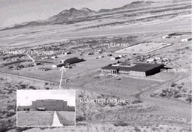
F igure 1. E xample image and annotations
Figure 1 illustrates the variety of content that may comprise an annotation: a text label, a simple graphic, an inset image. (In fact, an inset image is but one example of the rich multimedia content – sound, video, etc. -- that might comprise an annotation.). Figure 1 also illustrates the crucial relationship between annotations and specific locations on a map or image.
3. Requirements
This document specifies an XML vocabulary and document structure (an application schema) that applies GML features and relationships to image and map annotations. The next seven sections use simple examples to explain each requirement of annotations, and to show how one can meet those requirements in XML.
3.1 Annotations are independent features
At first glance, one might choose simply to append annotations to the encoding of maps or images. This has been the practice for image/graphic formats such as the National Imagery Transfer Format (NITF/BIIF). However, effective multi-purpose usage over the Web requires access to each annotation in its own right, so as to (re)use it independently of its source image, and to link it with other maps or images. E ncoding each annotation as an independent entity also allows reuse of GML specifications and technologies such as Web Feature Servers, Location Organizer Clients, etc. We can allow this looser coupling by expressing annotations as distinct, identifiable entities, as in the following example:
<AnnotationList>
<AnnotationID="A234"> … </Annotation> <AnnotationID="C235"> … </Annotation> </AnnotationList>
3.2 Annotations must annotate something
In general, an annotation provides some sort of content and indicates what resource(s) that content applies to. Without a link to at least one map or image, the annotation's content would often become ambiguous or meaningless (e.g., a curved green arrow isn't much use by itself). So we need a reference to a map or image alongside the annotation's content, as shown in the following XML fragment:
<AnnotationID="233A">
<Contenttype="text"> Aerial view of facility XYZ </Content> <Annotatesxlink:href="http://my.server.net/image42.jpg"/> </Annotation>
This example features in-line text content ("Aerial view of facility XYZ "). Later we'll see examples of external content. This example annotates the image located at the URL "http://my.server.net/image42.jpg" using XML’s Xlink syntax. In general, the xlink:href attribute refers to either
• an entire file (as in the above example);
• a fragment of an XML document (this one or another) using the X Path/X Pointer syntax; • an element with an xlink:label attribute in this X ML document; or
• a dynamically created data-stream invoked through a URL GE T query.
This lets us annotate an image, a document, a GML feature or feature collection, even other annotations. In the absence of a GML geometry sub-element (see next), this annotation would apply to the entire resource (or XML fragment) to which it points.
3.3 Annotations often point to a spatial subset of a map or image
Many annotations apply only to a small, spatially defined subset of an image or map. Such annotations must specify which portion of the pointed-to image they actually apply to. In XML, we can encode this using a GML geometry under the Annotates element, as in the following example:
<AnnotationID="234A">
<Contenttype="text"> HQ building </Content>
<Annotatesxlink:href="http://my.server.net/image42.jpg"/>
<gml:Point><gml:coordinates>142,78</gml:coordinates></gml:Point> </Annotates>
</Annotation>
In the above example, the geometry sub-element is a single GML point; but it could consist of any GML geometry (a point, rectangle, line-string, polygon, or multiples of these) or a GML Box. For example:
<AnnotationID="235A">
<Contenttype="text"> HQ building </Content>
<Annotatesxlink:href="http://my.server.net/image42.jpg"/>
<gml:Polygon>
<gml:outerBoundaryIs><gml:LinearRing><gml:coordinates>
142,78 149,85 156,93 149,101 141,122 129,110 135,95
</gml:coordinates></gml:LinearRing></gml:outerBoundaryIs>
</gml:Polygon>
</Annotates> </Annotation>
One important detail is the Spatial Reference System (SRS) in which the geometry is defined.
• If the geometry does have an srsName attribute, rendering it for display may require transforming it into display coordinates. If this SRS matches that of the annotated map or image, this is most likely a simple affine transform, easily specified in an XSLT stylesheet; otherwise a full coordinate transform may be required, specified via X SLT extension functions or performed by some other mechanism.
Another important point: this geometry describes the portion of the map or image that the annotation applies to. This geometry is not a property of the annotation itself, but rather of its relationship to an image or map. This will become more apparent as we annotate several different maps or annotations with a single piece of content, as described next.
3.4 Annotations may link to multiple images or maps
We may often need to link an annotation to more than one image or map, e.g., to highlight the same feature at different scales, or at different times, as in the following example:
<AnnotationID="234A">
<Contenttype="text"> Headquarters building </Content> <Annotatesxlink:href="http://my.server.net/image42.jpg"/> …
</Annotates>
<Annotatesxlink:href="http://your.server.net/photo3205.png"/>
…
</Annotates>
</Annotation>
A given annotation must have a single Content element (containing the text “Headquarters building” in the example above); but the Annotates element may be repeated any number of times to link the content to multiple images or maps.
3.5 Annotations have different shapes on different images or maps
When an annotation is linked to more than one image or map, it will usually refer to a different portion of each image or map. (For example, the quadrilateral annotation labeled "HE LO PAD" in Figure 1 would look very different in an overhead view). As a result, an annotation usually has no intrinsic geometry of its own, apart from its relationship to maps or images. This is why a GML geometry appears on each Annotates sub-element -- rather than on the Content or on the Annotation as a whole.
One occasional exception to this rule is simple symbols -- stars, crosses, arrows perhaps – encoded in GML. The shape of these symbols would remain the same regardless of what they annotate, so they could be considered a property of the Contentelement. However, because these would likely be drawn from some external library, the Contentelement would not normally define the geometry in-line, but rather include it by reference just as it does for images or other external content (see next).
3.6 Annotations may have rich content
• Inset image:
<AnnotationID="234A">
<Content type="image/gif" xlink:href="http://my.server.net/close-up.gif" /> <Annotates>
… </Annotates> </Annotation>
• Graphical annotation (symbols, etc., reused across several annotations): <AnnotationID="234A">
<Contenttype="text/xml" xlink:href="http://my.server.net/symbols.xml#5pt_star" /> <Annotates>
… </Annotates> </Annotation>
E xternal links are useful when (i) the annotation's content is binary (thus not easily encoded in X ML), (ii) it already exists elsewhere and we don't want to duplicate it, or (iii) we wish to reuse the same content many times. In particular, this allows annotations consisting of images and GML or SVG geometry, but also potentially of images, or audio or video clips. As mentioned earlier, the xlink:href attribute contains a URI that may point to a file; a local or remote XML fragment, an element with an xlink:label attribute in the current X ML document; or a dynamically-created data stream.
3.7 Annotations may have properties
Finally, annotations usually need to be qualified as to their origin, their degree of certainty, rationale, etc. These elements may apply to the annotation's content, as in the following example:
<AnnotationID="234A">
<Contenttype="text"> HQ building </Content> <Title> Main Headquarters for the facility</Title> <Author> Mary Franklin </Author>
<DateTime>19990919</DateTime> <Certainty>High</Certainty>
<Rationale>This is the standard layout for these buildings.</Rationale> <Annotates>
… </Annotates> </Annotation>
Or these properties may qualify the annotation’s link(s) to maps or images:
<AnnotationID="234A"> <Content>
…
</Content>
<Annotatesxlink:href="http://my.server.net/image42.jpg"/> <AreaOfInterest> … </AreaOfInterest>
<Title>Smoke plume from chimney</Title>
<Author> Bill Ludlow </Author>
<DateTime> 20000922 </DateTime>
<Certainty> Tentative </Certainty>
<Rationale> Checked against Ikonos; monitored for 2 weeks </Rationale>
3.8 Requirements summary
In summary, image and map annotations are independent entities with one (or more) links to maps or images. They will usually have different shapes on different images or maps; and so the corresponding GML
geometry describes not the annotation itself, but its “footprint” on each image or map. Finally, an annotation may have inline or external content (or both), and properties describing its content and/or its link to each image or map it annotates.
The following section presents a Document Type Definition and XML Schema Definition that meet these requirements. This is followed by some guidelines for using the Location Organizer Folder document schema for image and map annotations. It’s not yet clear which approach will prove more successful (using a simple, new application schema vs. reusing / adapting / reinterpreting an existing, more complex schema); both are included here for discussion.
4. Simple Schema
4.1 Summary
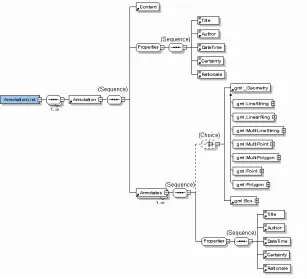
The following document tree would meet the requirements spelled out earlier:
F igure 2. Document tree
As the diagram shows, a top-level AnnotationList has one or more Annotation elements; and each Annotation has one Content element, which may consist of character data OR it may be empty (with remote content referred to by X link attributes). The Annotation element also has a cluster of metadata (Title, Author, DateTime, etc.), and one or more Annotates elements linking it to maps or images.
annotation is presumed to apply to all of the pointed-to image or map. The Annotates element also has a cluster of metadata (Title, Author, DateTime, etc.) describing its link to the map or image.
4.2 Document Type Definition
The following Document Type Definition corresponds to the tree described previously. It refers to the GML 1.0 geometries (and GML Box) to describe the shape of an annotation on an image or map.
<!-- XML Annotations, DTD v0.3. -->
<!-- Incorporate GML 1.0 geometry --> <!ENTITY % gmlgeometry.dtd SYSTEM
"http://www.opengis.org/techno/specs/00-029/gmlgeometry.dtd"> %gmlgeometry.dtd;
<!-- A reusable cluster of metadata to qualify annotations -->
<!ENTITY % Properties "Title , Author , DateTime , Certainty , Rationale">
<!-- Standard XLink attributes other than xlink:href. --> <!ENTITY % xlinkRefAttrs "
xmlns:xlink CDATA #FIXED 'http://www.w3.org/2000/xlink/namespace/' xlink:type (simple|extended|locator|arc) 'simple'
xlink:role CDATA #IMPLIED xlink:title CDATA #IMPLIED
xlink:show (new|embed|replace) 'embed' xlink:actuate (onRequest|onLoad) 'onLoad' ">
<!-- Top-level list of annotations -->
<!ELEMENT AnnotationList (Annotation)+>
<!-- Every annotation has a locally unique ID (to facilitate reuse) --> <!ELEMENT Annotation (Content, %Properties;, Annotates+)> <!ATTLIST Annotation ID ID #REQUIRED >
<!-- Content may be inline text, or remote XML or multimedia linked in via the Xlink attributes. -->
<!ELEMENT Content (#PCDATA)> <!ATTLIST Content
type CDATA #REQUIRED %xlinkRefAttrs;
xlink:href CDATA #IMPLIED >
<!-- Identifies what map or image (and what spatial subset of it) is being annotated. No geometry here means the entire map or image is annotated.-->
<!ELEMENT Annotates ((%GeometryClasses; | Box)?, %Properties;)> <!ATTLIST Annotates
%xlinkRefAttrs;
xlink:href CDATA #REQUIRED >
<!-- Metadata qualifying the annotation or its link to a map or image. Complete list TBD. --> <!ELEMENT Title (#PCDATA)>
<!ELEMENT Author (#PCDATA)> <!ELEMENT DateTime (#PCDATA)> <!ELEMENT Certainty (#PCDATA)> <!ELEMENT Rationale (#PCDATA)>
No doubt practical usage will require additional elements and attributes within this basic structure --
4.3 XML Schema definition
This is an X ML schema corresponding to the previous tree. It uses the October 2000 XML Schema syntax (W3C Candidate Recommendation), and draws on the GML 2.0 geometry schema (OGC Document 01-016, OpenGIS GML Recommendation Paper, Revision 2.0). Of particular interest is the repeatable Annotates element, which has both an XLink attribute and a gml:_Geometry sub-element (this is an abstract type, which instance documents must instantiate with one of gml:Point, gml:Polygon, gml:LineString, etc.).
<?xml version="1.0"?>
<xsd:schema targetNamespace="http://www.opengis.net/xima" xmlns:xlink="http://www.w3.org/1999/xlink"
xmlns:gml="http://www.opengis.net/gml" xmlns="http://www.opengis.net/xima"
xmlns:xsd="http://www.w3.org/2000/10/XMLSchema"
elementFormDefault="unqualified" attributeFormDefault="unqualified">
<xsd:import namespace="http://www.opengis.net/gml"
schemaLocation="http://www.opengis.net/namespaces/gml/core/geometry.xsd"/> <xsd:import namespace="http://www.w3.org/1999/xlink"
schemaLocation="http://www.opengis.net/namespaces/gml/core/xlinks.xsd"/>
<xsd:element name="AnnotationList"> <xsd:complexType>
<xsd:sequence maxOccurs="unbounded"> <xsd:element ref="Annotation"/> </xsd:sequence>
</xsd:complexType> </xsd:element>
<xsd:element name="Annotation"> <xsd:complexType>
<xsd:sequence>
<xsd:element ref="Content"/> <xsd:group ref="Properties"/>
<xsd:element ref="Annotates" maxOccurs="unbounded"/> </xsd:sequence>
<xsd:attribute name="ID" type="xsd:ID"/> </xsd:complexType>
</xsd:element>
<xsd:element name="Content"> <xsd:complexType>
<xsd:attribute name="type" type="xsd:string" use="required"/> <xsd:attributeGroup ref="xlink:simpleLink"/>
<xsd:attribute ref="xlink:href" type="xsd:uriReference"/> </xsd:complexType>
<xsd:element name="Annotates"> <xsd:complexType>
<xsd:sequence>
<xsd:attribute ref="xlink:href" type="xsd:uriReference" use="required"/> </xsd:complexType>
</xsd:element>
<xsd:element name="Title" type="xsd:string"/> <xsd:element name="Author" type="xsd:string"/> <xsd:element name="DateTime" type="xsd:string"/> <xsd:element name="Certainty" type="xsd:string"/> <xsd:element name="Rationale" type="xsd:string"/> <xsd:group name="Properties">
<xsd:sequence>
<xsd:element ref="Title"/> <xsd:element ref="Author"/> <xsd:element ref="DateTime"/> <xsd:element ref="Certainty"/> <xsd:element ref="Rationale"/> </xsd:sequence>
</xsd:group> </xsd:schema>
5. Using a Location Organizer Folder for
annotations
The OpenGIS Geospatial Fusion Services Testbed (and subsequent Pilot Project) have developed the notion of a Location Organizer Folder. This is an XML document structure (schema) that bundles together
multimedia information related to a particular set of events and places. Although this schema was not designed to support image and map annotations; yet it can be applied to collections of annotations by reinterpreting certain elements in new ways, or by deriving a new schema from the LOF schema. The next three sections describe some ways to do this using one particular LOF schema, the one used by the Geospatial Fusion Services Pilot Project on Jan. 25, 2001
< http://www.opengis.net/namespaces/gfspp/lof.xsd> .
5.1 Motivation
Using the existing LOF schema for annotations promises to leverage existing and future LOF software, including feature servers, LOF viewer clients, LOF stylesheets, and the like. This adds value to these
components, while providing a shortcut to implementation for image and map annotations. Furthermore, the LOF structure makes explicit the list of maps or images necessary for a bundle of annotations. This is a practical improvement over the simple schema listed earlier, in which this list remains implicit.
The following sections highlight the parts of the LOF schema that are useful for image annotations; they also point out some LOF elements that could support annotations more effectively with small changes; and how to subclass (derive by restriction) a LOF special case to support image annotations.
5.2 Useful LOF elements
The primary challenge in reusing the LOF schema to support image annotations is identifying an element analogous to the Annotates element listed previously. This element describes the "footprint" of an annotation on a particular image or map; it is a "relationship with a shape". The geometry must be associated not with the annotation itself, but with its link to a map or image; and it must be repeatable so that a given annotation may be linked with multiple maps or images. The first challenge, therefore, is to find a LOF element that can contain such a "relationship with shape." The two most obvious LOF elements won't do:
• In the current LOF schema (v0.81 / 2001-01-25) this requirement rules out the lofMember / lof_feature family. E lements derived from these types (Airport, Building, etc.) may indeed have multiple geometries (as their location, extentOf, centerLineOf, footprint, etc.); they may even have multiple relationships (relationshipProperty, a.k.a. frontsOn). However both the geometry and relationship pertain to the feature itself; they are not associated with each other as required for annotations.
• As for the InformationElement family, each of these elements (GeoTextMessage, Image, etc.) also has a gml.rel:relationshipProperty and optional geometric properties, but these too are associated with the InformationElement rather than with each other. The geometric properties
(gml:AbstractGeometryPropertyType) do have optional X link attributes: these are clearly intended for remote (rather than in-line) geometry; yet this Xlink could be reinterpreted to allow the "relationship with shape" necessary for annotations. But the current LOF schema allows only one geometric property per InformationElement.
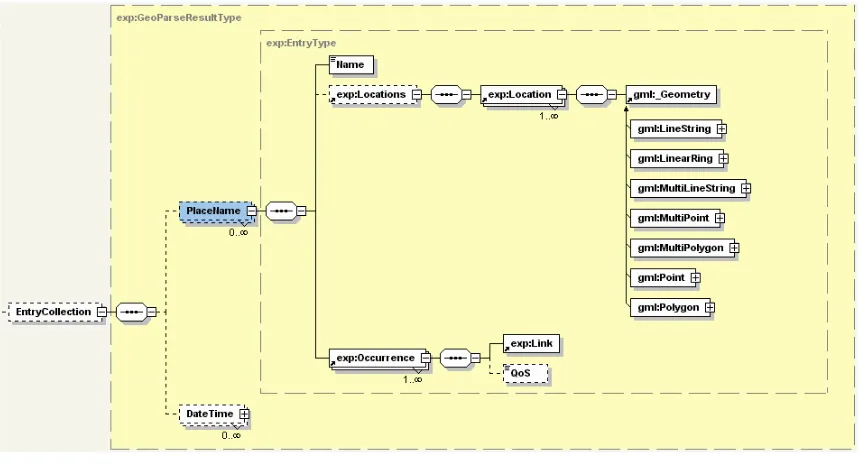
The LOF schema does provide a repeatable "relationship with shape" in the PlaceName element (under InformationElements). PlaceName has two sub-elements: Locations (which contain gml:_Geometry
elements) and Occurrence (which contains a Link element with Xlink attributes). Figure 3 shows this part of the LOF schema:
Figure 3. LOF PlaceName provides a " relationship with shape"
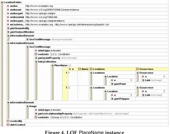
Figure 4. LOF PlaceName instance
Thus, the Locationsand Occurrencesub-elements of Placenamein an InformationElement's EntryCollection would support the "relationship with shape" required for annotations.
The second item of interest for annotations is the LOF BackgroundMap element (under areaOfInterest). This element provides some useful organization to the annotated images or maps: the repeatable
F igure 5. LOF BackgroundMap provides an explicit listing of annotated maps and images
F igure 6. LOF BackgroundMap instance
Appendix A presents the full, validated XML source for these instance fragments.
5.3 Useful modifications to LOF schema
• Make lof_features optional (right now at least one is required). This avoids having to carry a feature around just for validation when everything of interest in the LOF is an InformationElement.
• Derive an annotationProperty from gml:AbstractGeometryPropertyType, with extended X link
attributes. Allow it (optionally but repeatably) in the lof_feature and InformationElement content models.
• Provide ID attributes on the backgroundMaps, to facilitate simple Xlinks (from within the LOF or outside of it).
These would be ways to adapt the LOF schema and make it more flexible.
In addition XML Schema provides powerful facilities for deriving a new, special-purpose schema by
Appendix A. LOF instance for
annotations
The following XML listing expresses several image and map annotations using the LOF schema defined by the Geospatial Fusion Services Pilot Project as of Jan. 25, 2001
<http://www.opengis.net/namespaces/gfspp/lof.xsd>. The use of this LOF might be tourism; it highlights an airphoto of Boston, pointing out interesting historical sites. There are three annotations in all:
• The first is the GeoTextMessage"Boston-area overview"; it annotates all of the map labeled as "map1". • The second is the GeoTextMessage "U.S.S. Constitution"; it annotates a single point on "map1" and a
polygon on "map2".
• The third is an image labeled as "Closeup of U.S. Constitution", and annotates all of "map2".
Further down, two backgroundMap elements provide details on the maps labeled as "map1" and "map2".
The LOF also includes a couple of features (a Buildingand a MarineTerminal) that might be of possible interest.
?xml version="1.0" encoding="UTF-8"?> <!-- edited with XML Spy v3.5 -->
<LocationFolder xmlns="http://www.examples.org"
xmlns:xsi="http://www.w3.org/2000/10/XMLSchema-instance" xmlns:gml="http://www.opengis.net/gml"
xmlns:xlink="http://www.w3.org/1999/xlink"
xmlns:gml.rel="http://www.opengis.net/gml/relations"
xsi:schemaLocation="http://www.examples.org http://www.opengis.net/namespaces/gfspp/lof.xsd"> <gml:boundedBy>
<gml:Box srsName="EPSG:4326"> <gml:Coord>
<Building xlink:type="resource" fid="bldg12"> <gml:boundedBy>
<gml.rel:relationshipProperty type="arc" xlink:to="map1"/> </Building>
<gml:extentOf/> </MarineTerminal>
</gml:featureMember> <informationElement>
<GeoTextMessage xlink:type="extended">
<gml.rel:relationshipProperty xlink:type="arc" xlink:to="map1"/> <contents>Boston area overview<contents/>
</GeoTextMessage> </informationElement> <informationElement>
</gml:Polygon> </GeoTextMessage>
</informationElement> <informationElement>
<Image xlink:type="extended">
<gml.rel:relationshipProperty xlink:type="arc" xlink:from="http://www..." xlink:to="map2"/> <contents>Closeup of U.S.S. Constitution</contents>
</Image>
<backgroundMap xlink:type="resource"
xlink:href="http://ortho.mit.edu/server.cgi?wmtver=1.0&request=..." gml.rel:label="map1" xlink:title="Overview photo">
<backgroundMap xlink:type="resource"
xlink:href="http://coast.mit.edu/wmtserver.cgi?wmtver=0.9&request=..." gml.rel:label="map2" xlink:title="Charlestown Navy Yard">