THE PARTITION OF MULTI-RESOLUTION LOD BASED ON QTM
HOU Miao-le1, Xing Hua-qiao1, ZHAO Xue-sheng2, CHEN Jun3
1. Department of Computer Science, Beijing Institute of Civil Engineering and Architecture, Beijing 100044 China; 2. China University of Mining and Technology in Beijing, Beijing 100083 China;
3. National Geomatics Center of China, Beijing 100044 China
KEY WORD: Spherical Surface QTM, Multi- Resolution LOD, Viewpoint
ABSTRACT:
The partition hierarch of Quaternary Triangular Mesh (QTM) determine the accuracy of spatial analysis and application based on QTM. In order to resolve the problem that the partition hierarch of QTM is limited by the level of the computer hardware, the new method that Multi- Resolution LOD (Level of Details) based on QTM will be discussed in this paper. This method can make the resolution of the cells varying with the viewpoint position by partitioning the cells of QTM, selecting the particular area according to the viewpoint; dealing with the cracks caused by different subdivisions, it satisfies the request of unlimited partition in part.
About the first author: Hou Miaole, Female, 1974, Associate Professor of BUCEA who Get the PHD degree in 2005.7 at CUMTB. Main research topics are Spherical surface digital topology and 3D Rebuilding. Email: [email protected]
1. INTRODUCTION
The Quaternary Triangular Mesh (QTM) is an array of discrete grids. In the partition of QTM, an octahedron is used as a basis. It can simulate the surface of the Earth when it is recursively partitioned to a certain degree. QTM is efficient to deal with the global data because of its advantages of multi-resolution and hierarchy. In recent years, Scholars both at home and abroad made progress in the partition of the QTM. Dutton [1996] brought out a theory that a spherical triangle can be subdivided by the latitudes/longitudes. When a triangle is subdivided, the latitudes/longitudes pairs of any two of its three vertices are averaged to yield edge midpoint locations. Zhao Xuesheng[2001] introduced the recursive refining approach, to determine spatial relation between two spherical objects is approached by recursive refine based on QTM hierarchical partition. Zhang Shengmao[2008] analyzed the triangles which are subdivided based on QTM, the research indicated that along with the increase of the partition hierarchy, the area and change of the triangle become more stable. Sun Wenbin[2009]
improving the level of the computer hardware devices.
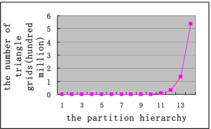
Figure 1 Correspondence between the number of triangle grids and the partition hierarchy
Spatial analysis and application based on QTM are depending on resolving the problem that improving the speed of the real-time rend of the triangle grids, that mean rending the globe fast and accurately by the way of the triangle grids. In the actual application, the range of observation is limited. The viewer may not care all area of the globe, but only interested in the part area. Therefore, building the partition model of multi-resolution LOD based on QTM, and decreasing the rending number of the triangle grids that are not in the interested area, are the effective way of improving the speed of the real-time rend of the triangle grids in the base of improving the accuracy that the triangles are subdivided base on QTM.
2. COMPARE THE EXISTING LOD ALGORITHM
LOD (Level of Details) technology was first introduced in 1976 by Clark, who mentioned that an object is shown by different resolutions or different levels of detail. There are three stages in the development of LOD technology, Discrete LOD; Continuous LOD; Multi-Resolution LOD.
In Discrete LOD, the models of different accuracy are built, and every model has its levels of detail. Coarse model can be used when observed from afar, while high- accuracy model can be used when observed nearly. Since different models lack of
continuity, the sight will be discontinuous in the progress of rending. Continuous LOD is a method showing compact model, which can produce models of infinite different levels of detail by the way of iterative operation, so it makes the models real-time shown. The most important characteristics of Continuous LOD is that everywhere in the same model has the same level of detail, however, the area which is near from viewpoint can be seen more clearly in real life. Therefore, Continuous LOD is only applied to simplifying the single object or small scale terrain. The basic idea of Multi-Resolution LOD is that a 3D scene is shown by different LOD levels. The LOD level of the area depends on the distance between the area and the viewpoint, and it will be updated automatically following the viewpoint. Based on the comparison above, Multi-Resolution LOD is adopted, observers can see the coarse model when they observe afar; and they can see the high- accuracy model when they observe nearly, at the same time, it reduces the pressure of the CPU.
3. THE SUBDIVISION OF MULTI-RESOLUTION
LOD BASED ON QTM
3.1 Partition The QTM Into Several Blocks
the partition hierarchy N=2,
the number of blocks T=2
the partition hierarchy N=3,
the number of blocks T=8
the partition hierarchy N=k,
the number of blocks T=2*4(k-2)
Figure 2 the correspondence between the partition hierarchy and the number of the blocks
3.2 Thinning Area
In the progress of partitioning the QTM, it is not necessary to subdivide the whole model, but only to subdivide the block which is near form the viewpoint. The block which is the nearest form the viewpoint is the thinning area. The partition hierarchy of QTM is supposed as k, according to the block strategy, the number of the block (B) is 2*4 k-2 , and B={B ,
B1…}, every block contain different numbers of triangle grids,
that mean B ={T ,T
distance between the block and the viewpoint, the block B
which is the nearest from the viewpoint is noted as Min B ,
and Min B ={ Center B0 ,Center B
The triangle grids are subdivided in the thinning area on the basis of original partition hierarchy. The area which the observers don’t care will keep the original partition hierarchy, while the thinning area will be subdivided again, shown in Figure 3.
(a) the low level of the (b) the high level of the partition hierarchy partition hierarchy in the
thinning area
Figure 3 the thinning area in the QTM
3.3 Deal With The Cracks
The QTM grids which are different resolutions will be adjoining by the time of the partition of Multi-Resolution LOD. Computer use discrete plane to express the information of hook face, so that the sharing edge or vertex of the QTM grids which are different resolutions will not be in the same plane. If the problem is not processed, the cracks will be produced in the process of visualization. As shown in Figure 4: the resolutions of the QTM grids A and the QTM grids B,C,D are different, the cracks will be produced in the rending if we don’t take steps.
Figure 4 the cracks caused by different subdivisions
The cracks must be eliminated in order to realize seamless and visualization expressing of the model based on QTM. Scholars both at home and abroad made progress in building the seamless model based on QTM, Sun Wenbin provided the vertex extension method of eliminating the cracks in 2008. He eliminated the cracks by the way of stretching the vertex of the higher resolution grids to the edge of the low resolution grids. The cracks caused by different subdivisions are eliminated by the way of the vertex extension in his method, it don’t change the partition method of the grids. At the same time, this method realizes seamless expressing of the model based on QTM on the base of hierarchical nesting. Based on the advantages above, the vertex extension method of eliminating the cracks that caused by different subdivisions is adopted in this article.
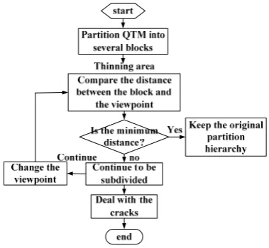
3.4 Algorithm Flow
In this paper, the QTM model is firstly partitioned into sever blocks on the base of the partition hierarchy and the latitudes/longitudes of the triangle grids; the distance between the blocks and the viewpoint are compared. The block which is the nearest from the viewpoint is selected as the thinning area, and the triangle grids in the thinning area will be subdivided. Finally, the cracks caused by different subdivisions will be dealt with. The algorithm flow chart is shown in Figure 5.
Figure 5 the algorithm flow chart
4. EXPERIMENTS
4.1 Experimental Tools
In this article, Visual C#2008 and Direct3D are selected as development tools. Direct3D is a powerful 3D image SDK provided by Microsoft. It can provide powerful rending functi-on in support of video card. The progress that rending the mod-el from 3D space to computer screens is realized by the fixed pipeline of Direct3D.
4.2 Experimental Effect
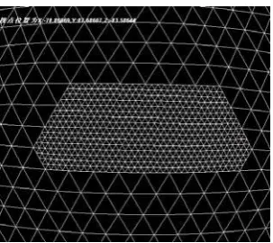
increases the partition hierarchy of the thinning area by this method. The experiment effect is shown as follow.
Figure 6 the partition hierarchy of QTM is six
Figure 7 the effect of zoom in area
Figure 8 the partition of Multi-Resolution LOD based on QTM
5. CONCLUSIONS
Along with the increase of the partition hierarchy, the number of triangle grids that are subdivided base on QTM is increased
four times. Huge amount of data will seriously affect the real-time and verisimilitude of the system. To resolve this problem, we provide the partition of Multi-Resolution LOD based on QTM; this method not only has the advantages of blocks, but also avoids a large number of pretreatment works, and it increases the partition hierarchy of the thinning area on the base of rending smoothly. As a result, this paper sets the stage for building the high revolution image model and terrain model.
REFERENCES
[1] Bartholdi III, Goldsman P. Continuous indexing of hierarchical subdivisions of the globe. International Journal of Geographical Information Science, 2001, 15(6): 489-522.
[2] DUTTON G. Encoding and Handling Geospatial Data with Hierarchical Triangular Meshes [A ].Proceeding of 7th International Symposium on Spatial Data Handling[C ]. Netherlands: Delft University of Techno logy, 1996. 34-43.
[3] Zhao, X. SH., and Chen, J. Hierarchical Spatial Relation Reasoning Based on Spherical O-QTM Partition. Acta Geodaetica et Cartographica Sinica,2001,30(4):355-360(in Chinese).
[4] Zhang, SH. M. Research of Global Remote Sensing Image Browser System Based on Octahedron Discrete Global Grids Model. Ph.D.Dissertation of EAST CHINA NORMAL UNIVERCITY, 2009,132pp(in Chinese)
[5] Sun, W. B., Zhao, X. SH., Gao, Y. L., Wang, H. B., Partition Methods and Character Analysis of Near-Equal Grids on Spherical Facet, Geography and Geo-Information Science, 2009,25(1):53-56(in Chinese).
[6] Bai, J. J., Sun, W. B., Zhao, X. SH., Character Analysis and Hierarchical Partition of WGS-84 Ellipsoidal Facet Based on QTM, Acta Geodaetica et Cartographica Sinica,2011,40(2):243-248(in Chinese).
[8] Du, Y., A Research on Key Technologies for Global Multi-resolution Virtual Terrain Environment. Ph.D.Dissert-ation of The PLA InformPh.D.Dissert-ation Engineering University, 2005,173pp(in Chinese).