INFORMATION MINING OF SPATIO-TEMPORAL EVOLUTION OF LAKES BASED
ON MULTIPLE DYNAMIC MEASUREMENTS
W. Feng, J. Chen*
School of Remote Sensing and Information Engineering ,Wuhan University, Wuhan,Hubei,China- (fengyixin,chen_jp)@whu.edu.cn Commission IV, WG IV/3
KEY WORDS: Lake evolution, Spatio-temporal change, Swap dynamic, Attenuation dynamic, Fragmentation dynamic
ABSTRACT:
Lakes are important water resources and integral parts of the natural ecosystem, and it is of great significance to study the evolution of lakes. The area of each lake increased and decreased at the same time in natural condition, only but the net change of lakes’ area is the result of the bidirectional evolution of lakes. In this paper, considering the effects of net fragmentation, net attenuation, swap change and spatial invariant part in lake evolution, a comprehensive evaluation indexes of lake dynamic evolution were defined,. Such degree contains three levels of measurement: 1) the swap dynamic degree (SDD) reflects the space activity of lakes in the study period. 2) the attenuation dynamic degree (ADD) reflects the net attenuation of lakes into non-lake areas. 3) the fragmentation dynamic degree (FDD) reflects the trend of lakes to be divided and broken into smaller lakes. Three levels of dynamic measurement constitute the three-dimensional "Swap - attenuation - fragmentation" dynamic evolution measurement system of lakes. To show its effectiveness, the dynamic measurement was applied to lakes in Jianghan Plain, the middle Yangtze region of China for a more detailed analysis of lakes from 1984 to 2014. In combination with spatial-temporal location characteristics of lakes, the hidden information in lake evolution in the past 30 years can be revealed.
1. INTRODUCTION
Lakes are important water resources and integral parts of the natural ecosystem. Since ancient times, lakes are closely related with human survival and development and play an irreplaceable role in runoff regulation, agricultural irrigation, transportation, urban and rural water supply, aquaculture, and maintaining ecological balance(Johnson et al., 2001). The lake evolution here is mainly affected by both natural factors (crustal movement, sediment deposition, and climate change)(Shadkam et al., 2016) and human activity (reclaiming farmland from lakes, urban expansion, and construction of large-scale water conservancy projects)(Yao et al., 2006; Wei et al., 2005a). Along with the population growth and the development of productive forces, the effects of human intervention on nature and ecological environment increased, which accelerated the evolution of lakes(Xiao et al., 2012).
A number of studies have been proposed for the evolution of lakes, studies on lake mainly focus on the lake changes at different time scales(Sironić et al., 2016), the landscape pattern evolution(Liu et al., 2014; Wu et al., 2016), the evolving types and causes of lakes(Jambrina-Enríquez et al., 2017; Shadkam et al., 2016), the impact of water pollution(Grochowska et al., 2015; Sevindik et al., 2014; Williamson et al., 2009), the management of water resources(Li et al., 2017; Zębek, 2014), and so on. The core concept of most methods is to calculate the total change of the lakes’ area. However, the area of each lake increased and decreased at the same time in natural condition, only but the net change of lakes’ area is the result of the bidirectional evolution of lakes. Considering the growth and decay of lakes in spatial evolution, the definition and calculation model of the swap dynamic degree (SDD), the attenuation dynamic degree (ADD), and the fragmentation dynamic degree (FDD) were proposed, which can efficiently judge the process of the spatial evolution of lakes. The comprehensive evaluation
restoration of the ecological environment and the sustainable utilization of lake resources.
2. RESEARCH METHODS 2.1 Classified lake transfer matrix
The classified lake transfer matrix reflects the dynamic process of the mutual transformation of the lake area in a certain period of time(Sánchez-Soto et al., 2012). It not only includes the information of all graded lakes at a certain time, but also contains more abundant information about the conversion from lakes since the beginning and the transferred quantity to lakes until the ending(Liu and Zhu, 2010). The general form of classified lake transfer matrix is:
00 01 0n 10 11 1n ij
n0 n0 nn
a a ... a
a a ... a
a
... ... ... ...
a a ... a
=
where a = area of lakes; n is the number of lake grades
i, j(i,i 0,1,2,...,n)= represent the type of lake grade before and after the transfer, respectively, of which 0 value represents non lake areas
ij
a = area of ist lakes that converted into jst lakes during the study period
0 j
a = area of non-lake areas that converted into jst lakes during the study period
i0
a = area of ist lakes that converted into non lake areas during the study period
lakes from the other lakes and non-lake areas at the ending of the study.
2.2 "Swap - attenuation - fragmentation" dynamic evolution measurement system
The traditional dynamic degree evaluation only considers the net change between lakes and other non-lake areas(Ciancio and Verhás, 2009), it tends not to involve much with the spatial interaction of lakes. In the existing dynamic researches(Liu and Zhu, 2010; Wang and Li, 2002), the parts of lakes that did not change in space in the transfer period are often neglected. Under the same net changes of lakes’ area, the smaller the invariant parts of lakes in space, the greater the dynamic degree during this period. On the basis of traditional dynamic degree, this paper presents the formulas for calculating the swap dynamic degree (SDD), the attenuation dynamic degree (ADD), and the fragmentation dynamic degree (FDD). The effects of net change, exchange change and space invariant in the dynamic degree evaluation are considered.
2.2.1 Swap Dynamic Degree ( SDD)
SDD considers the situation that lakes turn into other classes in certain areas, and transfer from other classes in other areas at the same time. The degree is determined by the ratio of the offsets of the shift and the spatial invariant, the value reflects the activity of spatial location shift of lakes in study period. For kst lakes, the function is shown as follows:
' n n n n in the n+1 order matrix, which represents the area of the ist lakes at the beginning of the study
n column in the n+1 order matrix, which represents the area of the jst lakes at the ending of the study
a in the n+1 order matrix, which represents the spatially invariant part of ist lakes during the study period. 2.2.2 Attenuation Dynamic Degree ( ADD)
ADD refers to the absolute dynamic change that lakes transfer into beach or construction land under the influence of nature or
human activities, it is a direct measure of the demise of lakes. For kst lakes, the function is shown as follows:
k0 0k
2.2.3 Fragmentation Dynamic Degree ( FDD)
Behaviors, such as human activities and urban construction, often divide the lakes. The water self-purification ability of the divided lakes weakens, and these lakes will be easily polluted and buried. The evolution dynamic of integrity of lakes is represented by FDD. For kst lakes, the function is shown as
3. SPATIO-TEMPORAL EVOLUTION OF JIANGHAN LAKE GROUP
3.1 Study area
The Jianghan Plain is located in the northern part of the Central Yangtze River drainage basin, Hubei Province, China, and
ranges from 28˚ 08’ to 30˚ 08’ N in latitude andfrom 111˚12’ to 114˚47’ E in longitude, with an altitude of <40 m in most parts. It is the largest plain in south China, encompassing a total area of 45456 km2 and 25 counties/cities(Gao et al., 2011). Geologically, it stems from the lower Yangtze and Hunan-Hubei-Guizhou platform and the old Jianghan basin of the late Paleozoic, and was formed in the past several hundred years by depositions from the Yangzte River and Han River. The climate is subtropical, with an annual precipitation of 1000–1500 mm, and a mean annual temperature of 16.5˚C. The Jianghan Plain contains a large number of lakes, most of which are dammed and fluvial lakes. Prior to impoldering, these lakes played an important role in flood mitigation, as well as providing water for drinking, irrigation, and aquaculture.
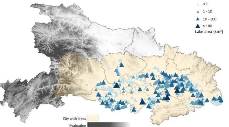
Figure 1. Distribution of the Jianghan Lake Group in 2014 3.2 Experimental data
The surface area measurements of lakes in 1984, 1989, 1995, 2000, 2005, and 2010 were acquired from Landsat TM remote-sensing data and lakes in 2014 were acquired from Landsat-8 images. The geometric correction, mosaic and enhancement of the remote sensing images in study area were carried out by ERDAS. And 7 phases of water information were extracted from remote sensing images by NDWI (Normalized Difference Water Index)(McFEETERS, 1996).
The time of year (e.g. dry or rainy season) significantly affects topographies and remote sensing imagery. Data on the lake were obtained during specific periods: most of the images used in this study were obtained from the wet season (June–September), and a few were obtained from October.
3.3 Analysis of spatial evolution of lakes
To identify an overall trend of the changes in these lakes, we classified the lakes and accounted the corresponding changes in 30 years (see Figure 2). The total area of lakes in the Jianghan Plain exhibited a decreasing trend from 1984 to 2014, and the intensity of decrease varies in different periods of time. Since 1980s, with the process of reform and opening up in China, industrial and agricultural production has exhibited rapid development. Driven by economic interests, the water management in the middle Yangtze reaches experienced a chaotic period. Blindly reclaiming land from lakes led to severe attenuation of lakes in this period. Before the year 2000, the water surface area of the natural lakes significantly declined, and the total area decreased by 272.282 km2 from 2459.807 km2 in 1984 to 2187.524 km2 in 2000. Since 2000, under the strategy of "leveling protective embankment to divert water, retreating the land to lakes", the area decay is relatively gentle. A total area of 96.903 km2 was lost until 2014, indicating that the strong reduction of the lakes in the 1980s was curbed. From 1984 to 2014, the lake area reduced by 369.186 km2.
Figure 2. Changes of the total area of the Jianghan Lake Group from 1984 to 2014
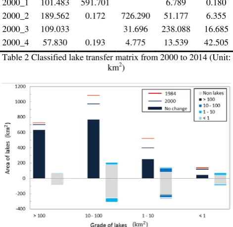
large lakes during the study period, while the distance between the blue line and blue area indicates the amount of swap change in the large lakes. The second column shows the interactive evolution between large lakes and other types. The increase of other types into large lakes during the study period is shown above the horizontal axis, and the reduction of large lakes into other types is overlay displayed below the horizontal axis.
2000_0 2000_1 2000_2 2000_3 2000_4 1984_0 59.653 178.762 81.283 40.053
1984_1 88.249 632.676 0.510 0.226
1984_2 255.329 766.701 53.611 7.544 1984_3 210.437 7.746 27.014 249.353 25.231 1984_4 77.448 0.079 0.568 11.254 45.788 Table 1 Classified lake transfer matrix from 1984 to 2000 (Unit:
km2)
2014_0 2014_1 2014_2 2014_3 2014_4 2000_0 52.948 158.809 100.766 48.324 2000_1 101.483 591.701 6.789 0.180 2000_2 189.562 0.172 726.290 51.177 6.355 2000_3 109.033 31.696 238.088 16.685 2000_4 57.830 0.193 4.775 13.539 42.505 Table 2 Classified lake transfer matrix from 2000 to 2014 (Unit:
km2)
Figure 3. Guide map of lake evolution in 1984-2000
Figure 4. Guide map of lake evolution in 2000-2014 Combined with the transfer matrix, the lake transfer situation in 1984-2000 and in 2000-2014 was analyzed. The related conclusions were as follows:
(1) There is a certain degree of decay in lakes with all grades. The spatial dynamics of lakes are dominated by interactive change, in which the conversion between lakes and non-lake regions is the most significant, showing a high degree of spatial activity. In addition to the net attenuation of lakes, there have been a lot of conversion and recovery in the past thirty years. With the development of urbanization, the interaction between lakes and lands has been more frequent as the swap dynamic degree appeared significant increase.
(2) The interactive evolution in lakes is mainly reflected on conversion between large and medium lakes, mostly for large lakes converted to medium lakes by decomposition or landfill, (53.611 km2) with a certain degree of restoration of medium lakes to large lakes (27.014 km2). The dominant trend was that larger lakes are segmented. As an exception, the Four-lakes Watershed plays an important role in flood control, drainage, and runoff regulation. Considering its high stability, it basically did not be decomposed into smaller lakes.
4. DYNAMIC EVOLUTION ANALYSIS IN JIANGHAN PLAIN
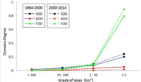
On the basis of two transfer matrixes, the amount of spatial invariant, increase, decrease and multiple variations of lakes at all grades in 1984-2000 and in 2000-2014 can be analyzed. The SDD (Equation (2)), ADD (Equation (3)), FDD (Equation (4)) of lakes were calculated, and the statistical result is shown in Table 5. The visual comparison of SDD, ADD, and FDD in 1984-2000 and in 2000-2014 is essential to further assess the evolution of lakes in Jianghan Plain (see Figure 5).
akk ak0−a0k
n n
ik kj i 1 j 1
a a
= =
−
∑
∑
Dk Ik Ik - Dk1 632.676 28.596 7.089 88.985 67.478 -21.507
2 766.701 76.567 187.355 316.484 206.855 -109.630
3 249.353 129.154 331.157 270.427 146.148 -124.279
4 45.788 37.395 582.812 89.348 73.054 -16.294
akk ak0−a0k
n n
ik kj i 1 j 1
a a
= =
−
∑
∑
Dk Ik Ik - Dk1 591.992 48.535 6.604 108.162 53.312 -54.850
2 726.219 30.753 191.928 247.337 195.280 -52.057
3 237.868 8.267 305.597 157.633 172.271 14.638
4 42.329 9.506 531.054 76.513 71.544 -4.969
Table 4 Information of lake dynamic evolution from 2000 to 2014 (Unit: km2)
Area (km2) 1984 - 2000 2000 - 2014
SDD ADD FDD SDD ADD FDD
> 100 0.013 0.003 0.001 0.013 0.006 0.001 10 - 100 0.034 0.006 0.015 0.038 0.003 0.019 1 - 10 0.073 0.032 0.083 0.095 0.002 0.092 < 1 0.199 0.051 0.796 0.241 0.016 0.896 Table 5 "Swap - attenuation - fragmentation" dynamic evolution
measurements of lakes in Jianghan Plain
Figure 5. Comparison of dynamic degrees of lakes at all grades (1) The Four Great Lakes exhibit an extremely low degree of dynamic levels, which are related to the high degree of emphasis on their functions of flood control and storage. Large lakes and medium-sized lakes are the main force of lake attenuation, their attenuation has been controlled since entering the new century. The overall dynamic degree of large lakes and medium lakes is also low. While the small lakes with an area of less than 1 km2 showed a high degree of dynamic levels, indicating that the spatial distribution of small lakes is extremely unstable.
(2) For the Four Great Lakes and large lakes, the spatial dynamics were mainly composed of interactive changes. The SDD accounted for more than 60% of the total dynamic in 1984-2000 and in 2000-2014. The medium-sized lakes were characterized by SDD and FDD, while the small lakes were dominated by FDD. The spatial dynamics of small lakes were mainly presented as the decomposition and aggregation between the small lakes and the lagers. The attenuation of lakes in Jianghan Plain has been curbed since 2000, and the types of lake transfer also changed along with the development of society and economy.
(3) Through the comparison of two study periods, dynamic evolution trends of lakes with all grades varied between 1984-2000 and 1984-2000-2014. Results show that since 1984-2000, 1) As a result of the increase in area attenuation of the Four Great Lakes, the ADD also increased, while their SDD and FDD were
their ADD has decreased in different degrees since 2000, and the overall dynamics showed a downward trend. The net attenuation process of lakes has slowed down, and the attenuation trend has been cubed. However, both of their SDD and FDD increased to a certain extent. The proportion of interactive changes in space evolution structure is further enhanced, and the evolution flow of lakes is more complicated.
CONCLUSION
Cause the fixedness and uniqueness of lake evolution in space, analysis based on area change can not truly reflect the dynamic evolution of lakes. To truly express the changes in lake variation, it is necessary to build a comprehensive analysis system that considers the net attenuation, net decomposition and interactive changes in lakes and reveal the corresponding implied information. This paper constructs the "Swap - attenuation - fragmentation" dynamic measurement system and analyzes the lake transfer in Jianghan Plain during 1984-2000 and 2000-2014. By comparing the lake transfer before and after 2000, the dynamic characteristics and evolution of lakes at different grades in Jianghan Plain are more clearly identified, and the quantitative statistics of the bidirectional change and variation process in lake evolution is realized.
The overall decay in Jianghan Plain has been eased since entering the new century. Reclaiming farmland from lakes on a large scale was under control, and the attenuation tendency of lake area was alleviated. However, with the acceleration industrialization and urbanization, some new characteristics of lake evolution have been developed in Jianghan Plain. The development of tourism industry and wetland construction led to the rapid changes of large lakes in space. Under the influence of city construction and industrialized farming around the lake, the comprehensive activity of lake evolution increased in general.
This paper constructs the dynamic evolution measurements of lakes, mining and evaluating the hidden process of exchange, implicit conversion and decomposition in lake evolution combined with spatio-temporal location information. The proposed methods provide a new idea for understanding the spatial and temporal dynamics of lake and its driving forces, but also make up for the shortage of traditional dynamic method to judge the evolution of lakes with spatial landscape. The results of this study are of great significance for more accurate evaluation of the systematic process of lakes, the improvement of ecological environment and the sustainable utilization of lake resources.
ACKNOWLEDGEMENTS
REFERENCES
Ciancio, V., Verhás, J., 2009. On the Representation of Dynamic Degrees of Freedom. Journal of Non-Equilibrium Thermodynamics, 18(1), pp.39-50.
Gao, R.T., Jiang, T.T., Bei-Dou, X.I., Qi-Gong, X.U., Zhang, H., Wang, H.J., 2011. Study on Ecoregion Techniques of Lake Nutrients in Hubei District. Research of Environmental Sciences, 24(1), pp.43-49.
Grochowska, J., Brzozowska, R., Łopata, M., Dunalska, J.,
2015. Influence of restoration methods on the longevity of changes in the thermal and oxygen dynamics of a degraded lake. Oceanological and Hydrobiological Studies, 44(1), pp.18-27.
Guo, S.L., Huang, G.X., Wang, Z.F., Wen, K.D., 2015. Lakes in Hubei Province. Hubei Science and Technology Press: Wuhan. Jambrina-Enríquez, M., Recio, C., Vega, J.C., Valero-Garcés, B., 2017. Tracking climate change in oligotrophic mountain lakes: Recent hydrology and productivity synergies in Lago De Sanabria (Nw Iberian Peninsula). Science of the Total Environment,590,pp.579-591.
Johnson, N., Revenga, C., Echeverria, J., 2001. Ecology. Managing water for people and nature. Science, 292, pp.1071-1082.
Li, Y., Jalil, A., Du, W., Gao, X., Wang, J., Luo, L., Li, H., Dai, S., Hashim, S., Yu, Z., Acharya, K., 2017. Wind induced reverse flow and vertical profile characteristics in a semi-enclosed bay of large shallow Lake Taihu, China. Ecological Engineering, 102, pp.224-233.
Liu, G.Y., Wang, P., Xie, H.L., 2014. Analysis of Ecological Landscape Pattern Change in the Poyang Lake Eco-Economic Zone of China. Advanced Materials Research, 864, pp.2639-2644.
Liu, R., Zhu, D.L., 2010. Methods for detecting land use changes based on the land use transition matrix. Resources Science, 32(8), pp.1544-1550.
McFEETERS, S.K., 1996. The use of the Normalized Difference Water Index (NDWI) in the delineation of open water features. International Journal of Remote Sensing, 17(7), pp.1425-1432.
Sánchez-Soto, L.L., Monzón, J.J., Barriuso, A.G., Cariñena, J.F., 2012. The transfer matrix: A geometrical perspective.
Physics Reports, 513(4), pp.191-227.
Sevindik, T., Tunca, H., Önem, B., Tamer, S., 2014. Temporal fluctuations of the phytoplankton community in an isolated floodplain lake (North Mollaköy Lake) of the Sakarya River (Northern Turkey). Oceanological and Hydrobiological Studies, 43(4), pp.381-392.
Shadkam, S., Ludwig, F., Vliet, M.T.H.v., Pastor, A., Kabat, P., 2016. Preserving the world second largest hypersaline Lake under future irrigation and climate change. Science of the Total Environment, 559, pp.317-325.
Sironić, A., Barešić, J., Horvatinčić, N., Brozinčević, A.,
Vurnek, M., Kapelj, S., 2016. Changes in the geochemical parameters of karst lakes over the past three decades – The case of Plitvice Lakes, Croatia. Applied Geochemistry, 78, pp.12-22. Wang, H.Z., Li, R.D., 2002. Bilateral change dynamic degree model for land use and its application to the land use Study of in suburban areas of wuhan. Remote sensing for land&resources, 2, pp.20-22.
Wei, X.H., Du, Y., NAKAYAMA, Y., Xue, H.P., Ren, X.Y., 2005a. Changes of lake surface area in the Four-Lake areaover the past decades. Resources and Environment in the Yangtze Basin, 14(3), pp.293-297.
Wei, X.H., Du, Y., Cai, S.M., Wu, S.J., Xue, H.P., 2005b. On the evolution of lakes in Hubei Province and counter measures.
Journal of Lake Sciences, 19(5), pp.530-536.
Williamson, C.E., Saros, J.E., Vincent, W.F., Smold, J.P., 2009. Lakes and reservoirs as sentinels, integrators, and regulators of climate change. Limnology & Oceanography, 54, pp.2273-2282.
Wu, H., Zeng, G., Liang, J., Chen, J., Xu, J., Dai, J., Sang, L., Li, X., Ye, S., 2016. Responses of landscape pattern of China’s two largest freshwater lakes to early dry season after the impoundment of Three-Gorges Dam. International Journal of Applied Earth Observations and Geoinformation, 56, pp.36-43. Xiao, F., Du, Y., Ling, F., Wu, S.J., Yan, Y., 2012. Analysis of relation between change of lakes and the spatial pattern of soils in the lake district in sihu drainage basin, middle reaches of yangtze river. Wetland Sciences, 10(1), pp.8-14.
Yao, S., Xue, B., Xia, W., 2006. Human impact recorded in the sediment of Honghu Lake, Hubei, China. Journal of Environmental Sciences, 18, pp.402-406.
Zębek, E., 2014. Response of cyanobacteria to the fountain
-based water aeration system in Jeziorak Mały urban lake.