isprsannals II 5 W1 31 2013
Teks penuh
Gambar
Dokumen terkait
Differential attribute profiles are estimated based on the sum of the second-order morphological gradients, whilst area opening performed on each attribute-zone essentially leads to
The proposed algorithm for building extraction in airborne LiDAR data can be divided into three key steps: Filtering, scan line segmentation, object based classification.. 2.1
As can be seen from Table 2 with data acquired by using the auto acquisition time (the one suggested by the acquisition manager software) the following
This approach required a planning of the recording strategies adopted by the different specialists involved in the project and the structuring of the collected data in a way that
After the automatic segmentation of the hand tool impressions, the evaluation of the selected tool marks and their replicas has produced significant conclusions about the Bronze
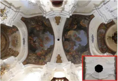
The solution in those cases was to use a flat panel to shield the backlight avoiding the strong light imbalance and the relatively dark foreground (Fig.8). Figure 8
models, oriented on the basis of the original position (horizontation and verticality), and proportioned according to the scale concerning the corresponding portions of the
In this study, Leica Cyclone 7.3 was used to process point cloud data produced by the laser scanner.. Leica Cyclone software is specifically designed for the Leica
