Conference paper
Teks penuh
Gambar
Garis besar
Dokumen terkait
The Normalized Difference Vegetation Index (NDVI) is a simple graphical indicator that can be used to analyze remote sensing measurements, typically but not necessarily from a space
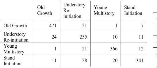
This study investigated the applicability of MODIS 250m satellite images to classify total forest area and compare with as old forest cover data set produced
In this context, this study aims to evaluate the use of ASTER sensor images, along techniques of remote sensing and digital image processing for the mapping
Panoramic images are increasingly used for cultural heritage The International Archives of the Photogrammetry, Remote Sensing and Spatial Information Sciences, Volume XL-5,
IIRS launched pilot project and started EDUSAT satellite based distance learning outreach program on Remote Sensing and Geoinformatics to address the needs of Users who
hilly and plain regions, have been selected for testing and verification of techniques using IRS (Indian Remote Sensing Satellites), LISS-III, LISS-IV satellite data of
Aerosol optical depth retrieval over land surface using remote sensing employs the use of radiative transfer simulations and/or simultaneous measurements of
After pre-processing of satellite images for monitoring temporal changes in land use, classification maps were done using artificial neural network, and thereby the land cover maps of
