isprsarchives XL 4 W4 13 2013
Teks penuh
Gambar
Dokumen terkait
In this study, Remote Sensing (RS) and Geographic Information Systems (GIS) techniques were integrated to map out and assess the changes of Land Use/Land Cover (LULC) maps in
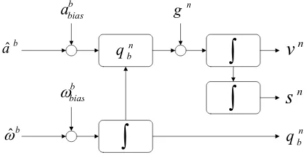
The International Archives of the Photogrammetry, Remote Sensing and Spatial Information Sciences, Volume XL-4/W4, 2013 ISPRS Acquisition and Modelling of Indoor and
Lastly, 3D model allows more semantic annotations to be presented, it The International Archives of the Photogrammetry, Remote Sensing and Spatial Information Sciences,
The Location of Semantic Reference is aggregated by the Semantic Reference Object, which is realized by the Semantic Absolute Location with information of a Semantic
The first method detects the beacon frames send out by mobile devices, laptops and other Wi-Fi enabled devices in range using Libelium Meshlium Xtreme monitors
• Semantics of the different subspaces in INSM is determined for original building data based on subspaces’ definitions in INSM. The main difficulty of automation is
based approach enables flexible extensions for a priori informa- tion. Motivated by the need to perform semantic and geometrical reconstruction of 3D point clouds a method closing
The colours in the RGB scale of the 3D model show the deviation between the points of the Agisoft Photo Scan cloud, then from drone survey, and those of the RISCAN Pro cloud,
