INTEGRATION OF POINT CLOUDS ORIGINATED FROM LASER SCANER AND
PHOTOGRAMMETRIC IMAGES FOR VISUALIZATION OF COMPLEX DETAILS OF
HISTORICAL BUILDINGS
Cihan Altuntas
Selcuk University, Engineering Faculty, Department of Geomatics, Alaeddin Keykubat Kampüsü, 42075 Selcuklu, Turkey - [email protected]
Commission V, WG V/4
KEY WORDS: Dense Point Cloud, Image Based Point Cloud, Laser Scanning, Photogrammetry, Integration, Three-Dimensional Model,
ABSTRACT:
Three-dimensional (3D) models of historical buildings are created for documentation and virtual realization of them. Laser scanning and photogrammetry are extensively used to perform for these aims. The selection of the method that will be used in three-dimensional modelling study depends on the scale and shape of the object, and also applicability of the method. Laser scanners are high cost instruments. However, the cameras are low cost instruments. The off-the-shelf cameras are used for taking the photogrammetric images. The camera is imaging the object details by carrying on hand while the laser scanner makes ground based measurement. Laser scanner collect high density spatial data in a short time from the measurement area. On the other hand, image based 3D (IB3D) measurement uses images to create 3D point cloud data. The image matching and the creation of the point cloud can be done automatically.
Historical buildings include more complex details. Thus, all details cannot be measured by terrestrial laser scanner (TLS) due to the blocking the details with each others. Especially, the artefacts which have complex shapes cannot be measured in full details. They cause occlusion on the point cloud model. However it is possible to record photogrammetric images and creation IB3D point cloud for these areas. Thus the occlusion free 3D model is created by the integration of point clouds originated from the TLS and photogrammetric images.
In this study, usability of laser scanning in conjunction with image based modelling for creation occlusion free three-dimensional point cloud model of historical building was evaluated. The IB3D point cloud was created in the areas that could not been measured by TLS. Then laser scanning and IB3D point clouds were integrated in the common coordinate system. The registration point clouds were performed with the iterative closest point (ICP) and georeferencing methods. Accuracy of the registration was evaluated by convergency and its standard deviations for the ICP and residuals on the control points for the georeferencing method.
1. INTRODUCTION
Documentation of historical buildings are very important for rebuilt and reconstruction of them when they are destroyed. Their reconstruction with the keep their original shapes and size is possible with their three-dimensional (3D) models. The creation of their 3D digital model is effective methods on documentation of cultural heritage. It requires measurement 3D spatial data in a particular space from the whole object surface. Photogrammetry is traditional methods on documentation of historical artefacts (Remondino, 2014; Bosch et al. 2005; Toz and Duran, 2004; Lingua et al., 2003). However the measurement to all details wit particular spaces by the photogrammetry require more time and labour. Thus some characteristic points which represent the shape are measured from the images. On the other hand laser scanning has been extensively used to creating 3D model of cultural heritage for two decades (Altuntas et al., 2014; Akca et al., 2006). Terrestrial laser scanner (TLS) collects high density 3D spatial data from the measurement area in a short time. The historical buildings have complex details. All details cannot be measured by TLS since the TLS makes ground based measurement. On the other hand, 3D virtual modelling and realization needs photogrammetric and laser scanning data (Remondino, 2011;
Grussenmeyer et al., 2011). Texture data of photogrammetric images are matched with the laser point cloud for creation of 3D virtual model. In addition different measurement techniques have been used for creation 3D model of historical buildings (El-Hakim et al., 2007; Kulur and Sahin, 2008; Chiabrando and Rinaudo, 2013; Altuntas and Yildiz, 2013).
Image based 3D (IB3D) modelling have been performed automatically by the interest points detected from the images. 3D spatial positions and structure from motion are estimated from the matched images in a short time (Chiabrando and Spano, 2013; Grussenmeyer et al., 2012; Barazzetti et al., 2010). The dense IB3D point cloud has been created by matching the image pixels. In this study, IB3D point clouds have been created for the areas that could not be measured by the TLS. Then the point clouds originated from laser scanning and images were integrated by ICP and georeferencing.
2. POINT CLOIUD ACQUISITION METHODS 2.1 Terrestrial laser scanning
TLS measures local coordinates and intensity of the laser light reflected from the measured points. In addition color data can
be recorded for the measured points. The laser scanner instruments use direct time-of-flight, indirect time-of-flight and triangulation methods to measure distance from instrument to object point. The triangulation laser scanners have small measurement distance because of the inherent characteristics of the instrument. Their measurement distance is about 8 meters. The measurement distance of laser scanner that uses indirect-time-of-flight technique varies between 100 to 300 meters. Finally the measurement distance of laser scanner that uses direct time-of-flight techniques reaches more than three kilometres. On the reverse of the measurement distances, the accuracy of TLS that uses indirect time-of-flight technique is better than that uses direct time-of-flight technique. The specifications and measurement speed of TLS are getting better by the time. Generally, the measurement accuracies of TLSs are a few millimetres in a 100 meter. And they can collect points more than 500000 in per second.
The registration of laser scanning data has been done by control points (Alba and Scaioni, 2007) or point cloud coordinates and photographs (Dold and Brenner, 2006). The many techniques have been executed to registration of point clouds. The iterative closest point (ICP) is extensively used to registration of point clouds (Zhang, 1994). The registration of point clouds by the ICP have been applied iteratively with the conjugate closest points between them. It has high accuracy result. The accuracy of the ICP is a little affected by the space between the measured scan points (Altuntas, 2014).
The main steps on 3D modelling by TLS are below: -Overlap laser scanning
-Point cloud registration
-Occlusion measurements by other techniques
-Mesh creation
-Texture mapping and 3D virtual model
2.2 Dense image matching
Image based 3D (IB3D) point cloud can be created from the images by dense matching. Hereby high density 3D point positions can be measured with low cost. The procedure needs only camera and software for the processes. Off-the-shelf low cost cameras are used for this aims. Today many, commercial software such as SURE, MicMac, PMVS, Photoscan have been developed for creating IB3D point cloud, dense matching and structure from motion (Remondino et al., 2014). IB3D point cloud generation is attractive method especially for 3D object modelling (Barazzetti et al. 2010, 2011; Remondino et al., 2014) and creation of digital elevation model (Rothermel ve Haala, 2011).
Feature based matching with the interest points has been applied for photogrammetric triangulation of multi-image network. Many interest operators such as Förstner, SUSAN and FAST have been used for matching of images in practices (Jazayeri and Fraser, 2010). In addition, invariant image features (keypoints) have been used to match images. Then many keypoint detection metods such as SURF, ASIFT, BRIEF have been developed after introducing the SIFT. The candidate correspondence for each feature points are find after detecting the feature points from the set of images. The epipolar geometry constraints are used to limit the search area and find good matches (Fathi and Brilakis, 2011). The epipolar geometry is used to detect error matched feature points. It has been applied by RANSAC, least median of squares and maximum posteriori sample consensus (Barazetti et al. 2010). 3D coordinates of the matched features are then calculated. Two
sparse point clouds are created from two consecutive stereo pairs, then, camera motion is estimated by registering point clouds using the quaternion motion estimation (Fathi and Brilakis, 2011). After all, bundle adjustment is applied for the block that contains all images matched. So as to creation IB3D point cloud, each pixel is matched with candidate on the other images by the image match techniques. Then 3D point cloud coordinates which represent the map of the image area is calculated by the photogrammetric evaluation. The scale of the point cloud is performed by ratio of distances or coordinates of control points. More information about dense image matching and creation of IB3D point cloud can be found on Brazetti et al., (2010) and Fathi and Brilakis (2011).
3. MEASUREMENT
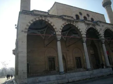
The studies were performed on front facade of the Sultan Selim mosque, Konya, Turkey (Figure 1). Laser scanning was made from 20m away. The space between the measured points is 2 cm on this measurement distance. Because the facade has more complex details, its fully measurement needs laser scanning from many stations. However, all details should be measured to creating the mesh model. The occluded parts were measured by photogrammetric images and point cloud was created from the images. The images were recorded by Nikon P50 camera (pixel array is 2592x1944, pixel size is 2.14 micron). The record of the images was planned as overlap with the point cloud of TLS. The image pixels (3 micron) corresponds about 1 cm on average imaging distance.
Figure 1. Front facade of the Sultan Selim Mosque.
Two study were performed for creating point clouds from dense matched images. The first study was executed on the left of the front facade. This part includes two window and mihrab among them. Sixty images were recorded to creation IB3D point cloud of this area, and 46130 points were created by Agisoft PhotoScan software (url-1) from dense matched images. The point cloud model was scaled by four control points (Figure 2). The PhotoScan is user friendly and high accuracy software.
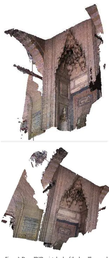
The second study was performed on the door that includes more complex shapes. The IB3D point cloud was created from 57 images and 3D positions of 2 million points were calculated (Figure 3). The scale has been executed by four control points.
Figure 2. Dense IB3D point cloud. The first study.
Figure 3. Dense IB3D point clouds of the door. The second study.
4. DATA INTEGRATION
Laser scanning and IB3D point clouds were integrated by the registration with the ICP method. The registration was implemented by PolyWorks software (url-2). The laser scanning data was selected as a reference and the IB3D point cloud was registered relation to reference system.
Figure 4. The TLS point cloud is reference. The IB3D point cloud of the first study was registered into reference system
with ICP. The scale bar shows low divergences. [m]
Figure 5. The TLS point cloud is reference. The IB3D point cloud of the second study was registered into reference system
with ICP. The scale bar shows low divergences. [m]
IB3D point cloud of the first study was registered using ICP with 0.003mm mean convergence and 6.4mm standard deviation. The differences between the conjugate points are very low after the registration (Figure 4). Similarly, the IB3D point cloud of the second study was registered to the reference system with mean convergence of 0.059mm and standard deviation of 8.7mm (Figure 5).
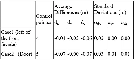
Another method for the integration of laser point cloud and IB3D point cloud is registration of each point cloud data into the georeference coordinate system. TLS point cloud and IB3D point cloud has been registered into the geodetic coordinate system by five and four control points respectively. Similarly, IB3D point cloud of the door has been registered by five control points. Thus the TLS point cloud and IB3D point cloud has been integrated by registering into the geodetic coordinate system. On this stage of the processes, we want to compare integration methods of point clouds by ICP and georeferencing. The TLS point cloud was accepted as a reference and ICP was implemented to the georeferenced IB3D point cloud. The changes on the control points were exploited to evaluate the registration methods (Tablo 1).
Table 1. Differences on the control points after applying ICP to the georeferenced point cloud.
Control
Laser scanner measures 3D spatial data in short time. Nevertheless, all details cannot be measured by TLS. Thus, un-imaged parts of the objects should be measured with the other methods. Dense point cloud creation from the images is the method that can be used as individual or complementary for laser scanning in documentation of cultural heritage. In this study, the surfaces that could not be measured by laser scanner are measured by creating point cloud from dense matched images. Today, many software have been used for dense matching and point cloud creation of the images. PhotoScan is user friendly software. TLS and IB3D point clouds have been integrated by ICP and georeferencing methods. The results of the both methods are satisfactory. According to the results obtained from the comparison, the accuracy of ICP is a little high then the georeferencing. The individual georeferencing of point clouds obtained from TLS and images requires control points that needs more time and labor.
REFERENCES
Akca, D., Remondino, F., Novàk, D., Hanusch, T., Schrotter, G., and Gruen, A., 2006. Recording and modeling of cultural heritage objects with coded structured light projection systems. 2nd International Conference on Remote Sensing in Archaeology, Rome, Italy, December 4-7, pp.375-382.
Alba, M., Scaioni, M., 2007. Comparison of techniques for terrestrial laser scanning data georeferencing applied to 3-D modelling of cultural heritage, in Proc. ISPRS 3D-ARCH 2007: Virtual Reconstruction and Visualization of Complex Architectures, In: The International Archives of the Photogrammetry, Remote Sensing and Spatial Information Sciences, ETH Zurich, Switzerland, Vol. XXXVI-5/W47, p. 8.
Altuntas, C., 2014. The effect of point density on the registration accuracy of a terrestrial laser scanning dataset. Lasers in Engineering, 28(3-4), pp. 213-221.
Altuntas, C., Yildiz, F., Baygul, E., 2014. Documentation of historical structures in the courtyard of Mevlana Museum by terrestrial LIDAR and Photogrammetry. Mediterranean Archaeology and Archaeometry, 14(2), pp. 249-258.
Altuntas, C., Yildiz, F., 2013. The registration of point cloud data from range imaging camera. Geodesy and Cartography, 39(3), pp. 106-112.
Barazzetti, L., Binda, L., Scaioni, M., Taranto, P., 2011. Photogrammetric survey of complex geometries with low-cost software:Application to the G1 temple in Myson, Vietnam. Journal of Cultural Heritage, 12(3), pp. 253-262.
Barazzetti, L., Scaioni, M., Remondino, F., 2010. Orientation and 3D modeling from markerless terrestrial images: combining accuracy with automation. The Photogrammetric Record, 25(132), pp. 356–381.
Bosch, R., Kulur, S., Gulch, E., 2005. Non-metric camera calibration and documentation of historical buildings. CIPA XXth International Symposium, Torino, 25 Sep-1 Oct, p.6.
Chiabrando, F., Rinaudo, F., 2013. TOF Cameras for Architectural Surveys. F. Remondino and D. Stoppa (eds.),
TOF Range-Imaging Cameras, DOI:
10.1007/978-3-642-27523-4_7, Springer-Verlag Berlin Heidelberg. pp.139-164.
Chiabrando, F., Spano, A., 2013. Points clouds generation using TLS and dense matching techniques. A test on approachable accuracies of different tools. ISPRS Annals of the Photogrammetry, Remote Sensing and Spatial Information Sciences, Strasbourg, France, Vol. II-5/W1, pp. 67-72.
Dold, C. and Brenner, C., 2006, Registration of terrestrial laser scanning data using planar patches and image data. In: The International Archives of the Photogrammetry, Remote Sensing and Spatial Information Sciences, Dresden, Germany, Vol. XXXVI Part 5, pp. 78-83.
El-Hakim, S., Gonzo, L. Voltolini, F., Girardi, S., Rizzi, A., Remondino, F., Whiting, E., 2007. Detailed 3D modelling of castles. International Journal of Architectural Computing, 5(2), pp. 199-220.
Fathi, H., Brilakis, I., 2011. Automated sparse 3D point cloud generation of infrastructure using its distinctive visual features, Advanced Engineering Informatics, 25(4), pp. 760-770.
Grussenmeyer, P., Alby, E., Landes, T., Koehl, M., Guillemin, S., Hullo, J.-F., Assali, P., Smigiel, E., 2012. Recording approach of heritage sites based on merging point clouds from high resolution photogrammetry and terrestrial laser scanning.
In: The International Archives of the Photogrammetry, Remote
Sensing and Spatial Information Sciences, Melbourne,
Australia, Vol. XXXIX-B5, pp. 553-558.
Grussenmeyer, P., Alby, E, Assali, P., Poitevin, V., Hullo, J.F., Smiciel, E., 2011. Accurate documentation in cultural heritage by merging TLS and high-resolution photogrammetric data. Proc. SPIE 8085, Videometrics, Range Imaging, and Applications XI, June 21, 808508, doi:10.1117/12.890087, http:/ /dx.doi.org/10.1117/12.890087
Jazayeri, I, Fraser, C.S., 2010. Interest operators for feature-based matching in close-range photogrammetry, The Photogrammetric Record, 25(129), pp. 24-41.
Kulur, S., Sahin, H., 2008. 3D cultural heritage documentation using data from different sources. In: The International Archives of the Photogrammetry, Remote Sensing and Spatial Information Sciences, Beijing, China, Vol. XXXVII-B5, pp. 353-356.
Lingua, A., Piumatti, P., Rinaudo, F. 2003. Digital photogrammetry: A standard approach to cultural heritage survey. In: The International Archives of the Photogrammetry, Remote Sensing and Spatial Information Sciences, Ancona, Italy, Vol. XXXIV-5/W12, pp. 210-215.
Remondino, F., Spera, M. G., Nocerino, E., Menna, F., Nex, F., 2014. State of the art in high density image matching. The Photogrammetric Record, 29(146), pp. 144-166.
Remondino, F., 2014. Photogrammetry - Basic Theory. In "3D Recording and Modelling in Archaeology and Cultural Heritage - Theory and Best Practices", F. Remondino and S. Campana (Eds), Archaeopress BAR Publication Series 2598, ISBN 9781407312309, pp. 63-72.
Remondino F., 2011. Heritage recording and 3D modeling with photogrammetry and 3D scanning. Remote Sensing, 3(6), pp. 1104-1138.
Rothermel, M., Haala, N., 2011. Potential of Dense Matching for the Generation of High Quality Digital Elevation Models, ISPRS Hannover Workshop 2011: High-Resolution Earth Imaging for Geospatial Information, IASPRS, Vol. XXXVIII-4/W19, p.6.
Toz, G., Duran, Z., 2004. Documentation and analysis of cultural heritage by photogrametric methods and GIS: A case study. In: The International Archives of the Photogrammetry, Remote Sensing and Spatial Information Sciences, Istanbul, Vol. XXXV, Part B5, pp. 438-441.
url-1: http://www.agisoft.com/
url-2: http://www.innovmetric.com/
Z. Zhang, 1994. Iterative point matching for registration of free-form curves and surfaces. International Journal of Computer Vision, 13(2), pp. 119–152.