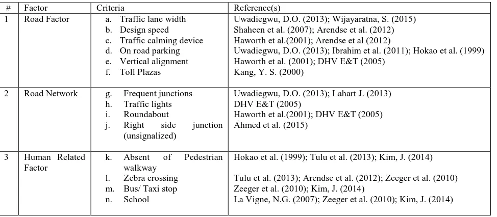
isprs archives XLII 4 W1 103 2016
Teks penuh
Gambar
Garis besar
Dokumen terkait
The primary aim of this study is to document the demographic parameters, the predominant injury mechanisms and severity, geographical positioning data (i.e coordinates of
The aim of this paper is to propose a fuzzy logic model for landslide susceptibility assessment in District Mansehra of Pakistan using the available information and the expert
The reason of doing the adjustment in three separate cases with using different datum points respectively is to follow the past practice of Jupem. At Jupem presently three set
3.2.1 Tidal Yearly Magnitude from 1984 to 2015: The magnitude of sea level rise from tide gauge data at stations along the coast of Peninsular Malaysia was computed from the
Based on the criteria, the new moon is considered visible if the altitude at sunset is at least 2 o and the elongation between the moon and the sun is at least 3 o , or at
The DHE is based on the quad-edge and its extension- the augmented quad-edge (Ledoux and Gold, 2007). These structures allow construction of models and their duals at the same
The following section discusses the methodology of collecting the pedestrian furniture and facilities data on site by using mobile GIS.. CAPTURING GPS LOCATIONS FOR PEDESTRIAN
A model was implemented in a simulation software, with the aid of Geographic Information Systems to produce an accurate representation of the environment, and observed the
